|
DES BARRES J. F. W. 1721 1824 publisher Samuel HOLLAND 1728 1801 and George CALLENDAR fl. around 1769 surveyors
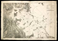
A Chart of the Harbour of Boston Composed from different Surveys; but principally from that taken in 1769 by Mr. George Callendar Late Master of His Majesty's Ship the Romney
London: Published by J.F.W. Des Barres in 'The Atlantic Neptune' 1775. Copper-engraved and etched map with aquatint on two joined sheets. Printed on laid paper with `J Bates' watermark and `JB' countermark in excellent condition. Sheet size: 30 1/4 x 42 5/8 inches. With: The explanatory text leaf titled as above. 1p. folio 25 1/2 x 19 inches. The finest and most celebrated sea chart of Boston Harbor ever produced and a highly important Revolutionary War map depicting details relating to the Siege of Boston: with the very rare explanatory text leaf. This is one the most important maps contained in Des Barres' The Atlantic Neptune and one of the most significant large-scale maps of the Revolutionary War. It provides an invaluable record of Boston at the beginning of the war covering the area from the environs of the city out into the open waters of Massachusetts Bay. A particularly striking feature is the use of boldly etched and subtly aquatinted details to capture the diverse topography of the region including the numerous hills islands and river estuaries. It is important to remember that this was issued as a working sea-chart and as such the cartographer has naturally concentrated on features such as depth soundings indicated by detailed lines and based on surveys by Samuel Holland and George Callendar and the navigable channels between the harbor's numerous shoals which are delicately outlined in stipple-engraving. Holland's original manuscript map is today preserved in the British Hydrographic Library at Taunton Somerset. The present map shows the city of Boston with its streets carefully outlined occupying a pear-shaped peninsula a position that would soon prove precarious to its British defenders in the escalating conflict. This is the second state of five of Des Barres' chart and is identical to the Henry Stevens Collection variant 96D in the National Maritime Museum Greenwich. This state shows a number of notable changes when compared with the original and was evidently altered to take particular account of the Siege of Boston April 19 1775 to March 17 1776. Henry Stevens noted that this state depicted the addition of "Numerous Forts Batteries Redoubts &c. which have been inserted in many places notably on the Charles Town peninsula and on the mainland between 'Willis Creek' and 'Mystic River' also on the east and north side of 'Charles River' below 'Cambridge'.also to the south of 'Boston Neck' and 'Dorchester Neck'.This state is almost as rare as the first state. It is found in some copies of the earliest edition of the Neptune." The accuracy scope and artistic virtue of Des Barres's Chart of the Harbour of Boston was apparent to his contemporaries and it became the main source map of the area for decades to come. Joseph Frederick Wallet Des Barres was born in Switzerland where his Huguenot ancestors had fled following the repeal of the Edict of Nantes. He studied under the great mathematician Daniel Bernoulli at the University of Basel before immigrating to Britain where he trained at the Royal Military College Woolwich. Upon the outbreak of hostilities with France in 1756 he joined the British Royal American Regiment as a military engineer. He came to the attention of General James Wolfe who appointed him to join his personal detail. During this period he also worked with the legendary future explorer James Cook on a monumental chart of the St. Lawrence River. Upon the conclusion of the Seven Years War Britain's empire in North America was greatly expanded and this required the creation of a master atlas featuring new and accurate sea charts for use by the Royal Navy. Des Barres was enlisted to survey the coastlines of Nova Scotia Newfoundland and the Gulf of St. Lawrence. With these extremely accurate surveys in hand Des Barres returned to London in 1774 where the Royal Navy charged him with the Herculean task of producing the atlas. He was gradually forwarded the manuscripts of numerous advanced surveys conducted by British cartographers in the American Colonies Jamaica and Cuba of which the present map is based on the work of Samuel Holland conducted in the 1760s. The result was The Atlantic Neptune which became the most celebrated sea atlas of its era containing the first systematic survey of the east coast of North America. Des Barres's synergy of great empirical accuracy with the peerless artistic virtue of his aquatint views created a work that "has been described as the most splendid collection of charts plates and views ever published" National Maritime Museum Catalogue. The Neptune eventually consisted of four volumes and Des Barres's dedication to the project was so strong that often at his own expense he continually updated and added new charts and views to various editions up until 1784 producing over 250 charts and views many appearing in several variations. All of these charts were immensely detailed featuring both hydrographical and topographical information such that in many cases they remained the most authoritative maps of the regions covered for several decades. Following the completion of The Neptune Des Barres returned to Canada where he remained for a further forty years becoming a senior political figure and a wealthy land owner living to the advanced age of 103. Cf. GuthornBritish Maps of the American Revolution referring to Holland's original manuscript 59/3; Krieger & Cobb p.107 1781 issue; Lingel Atlantic Neptune N91.2; National Maritime Museum Henry Stevens Collection K0713 HNS 96D; National Maritime Museum Catalogue 78-83; Nebenzahl Bibliography 3; Stevens Bibliography of the Atlantic Neptune unpublished pp.211-216; Sellers & Van Ee 945. Published by J.F.W. Des Barres in 'The Atlantic Neptune' unknown
Référence libraire : 17671

|
|
|
DES BARRES J. F. W. 1721 1824 publisher Samuel HOLLAND 1728 1801 and John KNIGHT
A plan of Fort Montgomery and Fort Clinton taken by His Majesty's forces under the command of Maj. Gen.l Sir Henry Clinton K.B: Survey'd by Major Holland Surv.r Gen.l &c. . With large inset titled: Part of Hudsons River shewing the position of Fort Montgomery and Fort Clinton with the Chevaux de Frieze cables chains &c to obstruct the passage of his Majesty's forces up the river. By Lieut. John Knight of the Royal Navy in 1777
London 1779. Engraved and aquatint map period hand colouring. 14 lettered references large inset with title as above. Rare revolutionary chart of the Hudson River showing the American defenses on the eve of the Battle of Fort Montgomery. On October 6 1777 a British force led by Lieutenant General Sir Henry Clinton attacked Forts Montgomery and Clinton from the landward side where the American defenses were only partially completed. Support from cannon fire from British ships on the Hudson River that had passed through the chevaux de frise on the lower river. By the end of the day both forts had fallen to the British who burned the forts and tore down the stonework buildings. However the battle was a pyrrhic victory for the British. The campaign against the forts caused delays in reinforcing General John Burgoyne at Saratoga where Americans forced the British surrender ten days later at the Battle of Saratoga before Clinton's forces could arrive. The present map which depicts the Forts and the River defenses prior to the battle is from The Atlantic Neptune the finest large scale sea atlas of the United States and Canadian Atlantic coastline ever produced. The maps in the atlas were produced over a seven-year period 1775-82 and are well known for their accurate portrayal of various sounds bays bars harbors as well as navigational hazards. This atlas was used extensively by the Royal Navy during the American Revolution. Des Barres studied under the great mathematician Daniel Bernoulli at the University of Basel before continuing on to the Royal Military College at Woolwich. On the outbreak of the Seven Years war in 1756 he joined the British Royal American Regiment as a military engineer. He came to the attention of General James Wolfe who appointed him to be his aide-de-camp. From 1762 Des Barres was enlisted to survey the coastlines of Nova Scotia Newfoundland and the Gulf of St.Lawrence while his colleague Samuel Holland charted the New England coast and further south. In 1774 Des Barres returned to England where he began work on the Neptune. His dedication to the project was so strong that often at his own expense he continually updated and added new charts and views up until 1784. That year he returned to Canada where he remained for a further forty years becoming a senior political figure and a wealthy land owner and living to the advanced age of 103. The Atlantic Neptune was the first British sea atlas of her North American colonies and one of the most important achievements of eighteenth century cartography. With an official commission from the Royal Navy Des Barres published the first volume in London in 1775 which was soon followed by further volumes. Des Barres' monumental endeavor eventually featured over two-hundred charts and aquatint views many being found in several states. All of the charts were immensely detailed featuring both hydrographical and topographical information. The Neptune met with the highest acclaim from the beginning and is today widely regarded as superior to all other atlases produced during its time. Henry Stevens identified only a single state of this chart issued coloured or uncoloured which appeared in some examples volume four part two of the Atlantic Nepture; the map however is not listed in the engraved list of maps for that section and given the rarity was likely not issued in all copies. National Maritime Museum: Henry Stevens Collection: HNS156; Cf. Phillips Atlases 1198; Hornsby Surveyors of Empire: Samuel Holland J.F.W. Des Barres and the Making of the Atlantic Neptune 2011. unknown
Référence libraire : 33200

|
|
|
Des Barres Joseph F. W. Joseph Frederick Wallet
A statement submitted by Lieutenant Colonel DesBarres for consideration : respecting his services from the year 1755 to the present time : in the capacity of an officer and engineer during the war of 1756 : the utility of his surveys and publications of the coasts and harbours of North America intituled The Atlantic neptune : and his proceedings and conduct as lieutenant governor and commander in chief of His Majesty's colony of Cape Breton 1796 Leather Bound
2019. Leather Bound. New. Leather Binding on Spine and Corners with Golden Leaf Printing on round Spine. Reprinted in 2019 with the help of original edition published long back 1796. This book is printed in black & white sewing binding for longer life Printed on high quality Paper re-sized as per Current standards professionally processed without changing its contents. As these are old books we processed each page manually and make them readable but in some cases some pages which are blur or missing or black spots. If it is multi volume set then it is only single volume if you wish to order a specific or all the volumes you may contact us. We expect that you will understand our compulsion in these books. We found this book important for the readers who want to know more about our old treasure so we brought it back to the shelves. Hope you will like it and give your comments and suggestions. Lang: - eng Pages 117. EXTRA 10 DAYS APART FROM THE NORMAL SHIPPING PERIOD WILL BE REQUIRED FOR LEATHER BOUND BOOKS. FOLIO EDITION IS ALSO AVAILABLE. hardcover
Référence libraire : LB1111006131134
|
|
|
Des Barres Joseph F. W. Joseph Frederick Wallet
A statement submitted by Lieutenant Colonel DesBarres for consideration respecting his services from the year 1755 to the present time : in the capacity of an officer and engineer during the war of 1756 : the utility of his surveys and publications of the coasts and harbours of North America intituled The Atlantic neptune : and his proceedings and conduct as lieutenant governor and commander in chief of His Majesty's colony of Cape Breton. 1796
2020. Paperback. New. Lang: - eng Pages 117. Reprinted in 2020 with the help of original edition published long back 1796. This book is Printed in black & white sewing binding for longer life with Matt laminated multi-Colour Soft Cover HARDCOVER EDITION IS ALSO AVAILABLE Printed on high quality Paper re-sized as per Current standards professionally processed without changing its contents. As these are old books we processed each page manually and make them readable but in some cases some pages which are blur or missing or black spots. If it is multi volume set then it is only single volume if you wish to order a specific or all the volumes you may contact us. We expect that you will understand our compulsion in these books. We found this book important for the readers who want to know more about our old treasure so we brought it back to the shelves. Any type of Customisation is possible with extra charges. Hope you will like it and give your comments and suggestions. paperback
Référence libraire : PB1111009674804
|
|
|
Des Barres Joseph F. W. Joseph Frederick Wallet
A statement submitted by Lieutenant Colonel DesBarres for consideration respecting his services from the year 1755 to the present time : in the capacity of an officer and engineer during the war of 1756 : the utility of his surveys and publications of the coasts and harbours of North America intituled The Atlantic neptune : and his proceedings and conduct as lieutenant governor and commander in chief of His Majesty's colony of Cape Breton. 1796 Hardcover
2020. Hardcover. New. Lang: - eng Pages 117. Reprinted in 2020 with the help of original edition published long back 1796. This book is Printed in black & white Hardcover sewing binding for longer life with Matt laminated multi-Colour Dust Cover Printed on high quality Paper re-sized as per Current standards professionally processed without changing its contents. As these are old books we processed each page manually and make them readable but in some cases some pages which are blur or missing or black spots. If it is multi volume set then it is only single volume if you wish to order a specific or all the volumes you may contact us. We expect that you will understand our compulsion in these books. We found this book important for the readers who want to know more about our old treasure so we brought it back to the shelves. Any type of Customisation is possible with extra charges. Hope you will like it and give your comments and suggestions. hardcover
Référence libraire : 1111009674804
|
|
|
Des Barres Joseph F. W. Joseph Frederick Wallet
A statement submitted by Lieutenant Colonel DesBarres for consideration : respecting his services from the year 1755 to the present time : in the capacity of an officer and engineer during the war of 1756 : the utility of his surveys and publications of the coasts and harbours of North America intituled The Atlantic neptune : and his proceedings and conduct as lieutenant governor and commander in chief of His Majesty's colony of Cape Breton 1796 Hardcover
2020. Hardcover. New. Lang: - eng Pages 117. Reprinted in 2020 with the help of original edition published long back 1796. This book is Printed in black & white Hardcover sewing binding for longer life with Matt laminated multi-Colour Dust Cover Printed on high quality Paper re-sized as per Current standards professionally processed without changing its contents. As these are old books we processed each page manually and make them readable but in some cases some pages which are blur or missing or black spots. If it is multi volume set then it is only single volume if you wish to order a specific or all the volumes you may contact us. We expect that you will understand our compulsion in these books. We found this book important for the readers who want to know more about our old treasure so we brought it back to the shelves. Any type of Customisation is possible with extra charges. Hope you will like it and give your comments and suggestions. hardcover
Référence libraire : 1111006131134
|
|
|
Des Barres Joseph F. W. Joseph Frederick Wallet
A statement submitted by Lieutenant Colonel DesBarres for consideration : respecting his services from the year 1755 to the present time : in the capacity of an officer and engineer during the war of 1756 : the utility of his surveys and publications of the coasts and harbours of North America intituled The Atlantic neptune : and his proceedings and conduct as lieutenant governor and commander in chief of His Majesty's colony of Cape Breton 1796
2020. Paperback. New. Lang: - eng Pages 117. Reprinted in 2020 with the help of original edition published long back 1796. This book is Printed in black & white sewing binding for longer life with Matt laminated multi-Colour Soft Cover HARDCOVER EDITION IS ALSO AVAILABLE Printed on high quality Paper re-sized as per Current standards professionally processed without changing its contents. As these are old books we processed each page manually and make them readable but in some cases some pages which are blur or missing or black spots. If it is multi volume set then it is only single volume if you wish to order a specific or all the volumes you may contact us. We expect that you will understand our compulsion in these books. We found this book important for the readers who want to know more about our old treasure so we brought it back to the shelves. Any type of Customisation is possible with extra charges. Hope you will like it and give your comments and suggestions. paperback
Référence libraire : PB1111006131134
|
|
|
DES BARRES Joseph F. Wallet 1721 1824
A View of Quebec from the South East
London: Published by J.F.W. Des Barres in 'The Atlantic Neptune' 1780. Etching with aquatint printed in sepia. On laid paper with 'J Bates' watermark and 'JB' countermark. Expertly repaired 1/2 inch hole to image. A very fine view of Quebec. This image is one of the most important of all the views included in Des Barres masterpiece: 'The Atlantic Neptune'. 'The Atlantic Neptune' was the first great marine atlas and one of the greatest achievements of eighteenth century cartography. Published in England in 1774 it contained over 250 charts and views of the North American and Canadian coasts. The charts were intensely detailed and contained both hydrographical and topographical details. The Neptune was compiled and published for the Royal Navy by Joseph F. W. Des Barres a Swiss cartographer who joined the Royal American Regiment as a surveyor. Des Barres fought in the French and Indian wars and was enlisted to survey the Canadian coastline. While his fellow surveyor Samuel Holland charted the New England coast Des Barres mapped the shoreline of Nova Scotia Newfoundland and the St. Lawrence River regions. In 1774 Des Barres returned to England where he compiled and published his monumental atlas; his dedication to the project was so strong that he published an updated version of the work every year until 1784. Des Barres' work was so superior to any other contemporary atlas that the maps were used as the standard charts of the East coast for over 50 years. The Neptune remains one of the most important atlases ever printed its views and maps chart the history of Canada and the United states and allow us to glimpse a forgotten land long changed by the passage of time. Spendlove writes that the 'large prints from The Atlantic Neptune are among the finest and most beautiful pictures of Canada ever made. Des Barres was an artist of great ability. and his delineation of ships was particularly effective and one could hardly find anything finer' The Face of Early Canada pp. 18-19. The present view is apparently taken from on board a ship on the St. Lawrence River looking north west towards towards the citadel and burgeoning city of Quebec. In the foreground are two finely-observed merchantmen their flags and pennants streaming out in the stiff breeze blowing up the river valley. This is an historically important image of Quebec as it looked twenty years after its capture by Wolfe drawn by an artist of high merit who took part in the 1759 campaign. Second state of 2 National Maritime Museum Greenwich Henry Newton Stevens Collection 125a; Cf. Spendlove The Face of Early Canada Chapter 4: "J.F.W. Des Barres and The Atlantic Neptune"; pp. 18-22; Debard "The Family Origins of Joseph Fredericks Wallet DesBarres: A Riddle Finally Solved" Nova Scotia Historical Review Vol 14 No. 2 1994 p.15; Stevens 125B. Published by J.F.W. Des Barres in 'The Atlantic Neptune' unknown
Référence libraire : 13223

|
|
|
DES BARRES J. F. W. 1721 1824; after William PIERIE
A View of Boston Taken on the Road to Dorchester
London: J. F. W. Des Barres 1776. Engraved view printed on laid paper engraved by James Newton after Pierie. Sheet size: 22 1/2 x 31 1/2 inches. First state. Repaired tears in lower margin. Rare view of Boston from Dorchester Heights published shortly after George Washington's first victory of the American Revolution. Following the Battles of Lexington and Concord American troops laid siege to Boston. Strategically Dorchester Heights offered commanding views of both Boston town and harbour. On March 4 1776 under the cover of darkness and with batteries firing from Roxbury and Cambridge to provide a diversion George Washington moved canon captured at Ticonderoga onto the Heights and fortified the position. Faced with little choice given the overwhelming strategic advantage General Howe retreated from Boston on March 17 giving George Washington and the Americans a decisive early victory in the war. The present view accomplished by British artillery officer William Pierie in 1773 depicts Boston Boston Harbor and Roxbury as it would have been seen by Washington and the American army. The Shirley-Eustis house the home of Governor William Shirley and later Governor William Eustis in Roxbury is visible in the middle ground and in the far distance the beacon is visible atop Beacon Hill. A rare view published in 1776 in the New England section of Des Barres monumental Atlantic Neptune. Joseph Frederick Wallet Des Barres was born in Switzerland where his Huguenot ancestors had fled following the repeal of the Edict of Nantes. He studied under the great mathematician Daniel Bernoulli at the University of Basel before immigrating to Britain where he trained at the Royal Military College Woolwich. Upon the outbreak of hostilities with France in 1756 he joined the British Royal American Regiment as a military engineer. He came to the attention of General James Wolfe who appointed him to join his personal detail. Des Barres returned to London in 1774 where the Royal Navy charged him with the Herculean task of producing an atlas of sea charts of the American coast. The result was The Atlantic Neptune which became the most celebrated sea atlas of its era containing the first systematic survey of the east coast of North America. Des Barres's synergy of great empirical accuracy with the peerless artistic virtue of his aquatint views created a work that "has been described as the most splendid collection of charts plates and views ever published" National Maritime Museum Catalogue. The Neptune eventually consisted of four volumes and Des Barres's dedication to the project was so strong that often at his own expense he continually updated and added new charts and views to various editions up until 1784 producing over 250 charts and views many appearing in several variations. Following the completion of The Neptune Des Barres returned to Canada where he remained for a further forty years becoming a senior political figure and a wealthy land owner living to the advanced age of 103. Henry Stevens Collection HNS97; Deak 132. J. F. W. Des Barres unknown
Référence libraire : 34921

|
|
|
DES BARRES JFW. 1721 1824 J. F.
A View of the Plaister Cliffs on the West Shore of Georges Bay
London: Published by J.F.W Des Barres in 'The Atlantic Neptune' 1781. Etching with aquatint printed in sepia. Printed on laid paper with watermark `J Bates' and countermark `JB'. A large-scale view of the scenery near Lakevale and Antigonish on the North West coast of Nova Scotia from 'The Atlantic Neptune' the first British sea atlas of her North American colonies This is a very fine scene depicting a dramatic point where the highlands of Nova Scotia cascade into the Gulf of St. Lawrence. This is the second state of this view and is identical to the Henry Stevens Collection variant 70B in the National Maritime Museum Greenwich. Des Barres studied under the great mathematician Daniel Bernoulli at the University of Basel before continuing on to the Royal Military College at Woolwich. On the outbreak of the Seven Years war in 1756 he joined the British Royal American Regiment as a military engineer. He came the attention of General James Wolfe who appointed him to be his aide-de-camp. From 1762 Des Barres was enlisted to survey the coastlines of Nova Scotia Newfoundland and the Gulf of St.Lawrence while his colleague Samuel Holland charted the New England coast. In 1774 Des Barres returned to England where he began work on the Neptune. His dedication to the project was so strong that often at his own expense he continually updated and added new charts and views up until 1784. That year he returned to Canada where he remained for a further forty years becoming a senior political figure and a wealthy land owner and living to the advanced age of 103. The Atlantic Neptune was the first British sea atlas of her North American colonies and one of the most important achievements of eighteenth century cartography. With an official commission from the Royal Navy Des Barres published the first volume in London in 1775 which was soon followed by further volumes. Des Barres' monumental endeavor eventually featured over two-hundred charts and aquatint views many being found in several states. All of the charts were immensely detailed featuring both hydrographical and topographical information. Des Barres' plates were used to print further editions up into the first decade of the nineteenth-century. The Neptune met with the highest acclaim from the beginning and is today widely regarded as superior to all other atlases produced during its time. Spendlove The Face of Early Canada Chapter 4: "J.F.W. Des Barres and The Atlantic Neptune"; pp. 18-22; Debard "The Family Origins of Joseph Fredericks Wallet DesBarres: A Riddle Finally Solved" Nova Scotia Historical Review Vol 14 No. 2 1994 p.15; National Maritime Museum: Henry Stevens Collection: K0231 HNS 70B. Published by J.F.W Des Barres in 'The Atlantic Neptune' unknown
Référence libraire : 3608

|
|
|
Des Barres Joseph F. Wallet
ANNAPOLIS ROYAL.ST. MARY'S BAY
London: J.F.W. Des Barres in THE ATLANTIC NEPTUNE 1781. 31 3/4 x 47 inches. Etching with roulette work with added hand color. Printed on two joined sheets. On laid paper with "J Bates" watermark and "JB" countermark. Fine. A print from THE ATLANTIC NEPTUNE which charts the Annapolis Royal with a coastal view of Gulliver's Hole and a descriptive text. THE ATLANTIC NEPTUNE was the first great marine atlas and one of the greatest achievements of 18th-century cartography. Published in England in 1774 it contains over 250 charts and views of the North American and Canadian coasts. The charts are intensely detailed and contain both hydrographical and topographical details. The .NEPTUNE was compiled and published for the Royal Navy by Joseph F.W. Des Barres a Swiss cartographer who joined the Royal American Regiment as a surveyor. Des Barres fought in the French and Indian wars and was enlisted to survey the Canadian coastline. While his fellow surveyor Samuel Holland charted the New England coast Des Barres mapped the shoreline of Nova Scotia Newfoundland and the St. Lawrence River regions. In 1774 Des Barres returned to England where he compiled and published his monumental atlas. His dedication to the project was so strong that he published an updated version of the work every year until 1784. Des Barres' work was so superior to any other contemporary atlas that the maps were used as the standard charts of the East Coast for over fifty years. The .NEPTUNE remains one of the most important atlases ever printed. Its views and maps chart the history of North America and allow us to glimpse a forgotten land long changed by the passage of time. This chart is an excellent 18th-century record of the first settlement in Canada. In 1605 two years before the first permanent British settlement at Jamestown three years before the founding of Quebec and fifteen years before the Pilgrims landed at Plymouth a small party of French explorers led by Sieur de Monts established Port Royal as the first settlement in Canada. The settlement was later renamed Annapolis Royal which is the name assigned to it in Des Barres' chart. Spendlove "J.F.W. Des Barres and The Atlantic Neptune" in THE FACE OF EARLY CANADA pp.18-22. Debard "The Family Origins of Joseph Fredericks Wallet Des Barres: A Riddle Finally Solved" in NOVA SCOTIA HISTORICAL REVIEW Vol. 14 No. 2 1994 p.15. J.F.W. Des Barres, in THE ATLANTIC NEPTUNE unknown
Référence libraire : WRCAM33749

|
|
|
DES BARRES JFW. 1721 1824 J. F.
Annapolis Royal. St. Mary's Bay
London: Published by J.F.W. Des Barres in 'The Atlantic Neptune' 1781. Etching with added hand-colour. On laid paper with 'J Bates' watermark and 'JB' countermark. A fine print from 'The Atlantic Neptune' which charts the Annapolis Royal with a coastal view of Gulliver's Hole and a descriptive text. 'The Atlantic Neptune' was the first great marine atlas and one of the greatest achievements of eighteenth century cartography. Published in England in 1774 it contained over 250 charts and views of the North American and Canadian coasts. The charts were intensely detailed and contained both hydrographical and topographical details. The Neptune was compiled and published for the Royal Navy by Joseph F. W. Des Barres a Swiss cartographer who joined the Royal American Regiment as a surveyor. Des Barres fought in the French and Indian wars and was enlisted to survey the Canadian coastline. While his fellow surveyor Samuel Holland charted the New England coast Des Barres mapped the shoreline of Nova Scotia Newfoundland and the St. Lawrence River regions. In 1774 Des Barres returned to England where he compiled and published his monumental atlas; his dedication to the project was so strong that he published an updated version of the work every year until 1784. Des Barres' work was so superior to any other contemporary atlas that the maps were used as the standard charts of the East coast for over 50 years. The Neptune remains one of the most important atlases ever printed its views and maps chart the history of North America and allow us to glimpse a forgotten land long changed by the passage of time. This chart is an excellent eighteenth century record of the first settlement in Canada. In 1605 two years before the first permanent English settlement at Jamestown three years before the founding of Quebec and fifteen years before the Pilgrims landed at Plymouth a small party of French explorers led by Sieur de Monts established Port Royal as the first settlement in Canada. The settlement was later renamed Annapolis Royal which is the name asigned to it in Des Barres chart. Spendlove The Face of Early Canada Chapter 4: "J.F.W. Des Barres and The Atlantic Neptune"; pp. 18-22; Debard "The Family Origins of Joseph Fredericks Wallet DesBarres: A Riddle Finally Solved" Nova Scotia Historical Review Vol 14 No. 2 1994 p.15. Published by J.F.W. Des Barres in 'The Atlantic Neptune' unknown
Référence libraire : 5598

|
|
|
DES BARRES Joseph Frederick Wallet 1721 1824.
Barrington Bay Nova Scotia.
London: Publish'd according to Act of Parliament by J.F.W. Des Barres Esqr. April 6 1776 DES BARRES Joseph Frederick Wallet 1721-1824. Barrington Bay Nova Scotia. London: Publish'd according to Act of Parliament by J.F.W. Des Barres Esqr. April 6 1776 2 sheets joined 30 4/8 x 42 inches. Fine engraved chart centered in Barrington Bay in Nova Scotia with extensive legend upper right old vertical folds a little toned at the edges. A magnificent chart from Des Barres's superb atlas The Atlantic Neptune published for the use of the Royal Navy of Great Britain. under the Directions of the Right Honble. the Lords Commissioners of the Admiralty. London 1774-1779 which included a comprehensive survey of the coasts of Nova Scotia the coasts and harbors of the Gulf and River of St. Lawrence and the Atlantic coast of North America from New York to Mexico and New England in more than 100 engraved charts views and elevations. Des Barres's service to the British Crown began in about 1752 when he enrolled as a cadet at the Royal Military Academy at Woolwich near London. Founded in 1741 the Academy was established to teach all the branches of mathematics necessary for men who would serve in the Artillery or as Engineers. Des Barres had already received an extensive education in his native Switzerland where he had studied both applied and theoretical mathematics at the University of Basle. Upon the completion of his training he became one of the first officers to be commissioned in the newly formed Royal American Regiment. Thus it was that at the close of the French and Indian War Des Barres was sent to America by the British Admiralty to survey the coasts of the Maritime Provinces. These provinces so recently acquired from France had never been adequately mapped and Des Barres spent the next ten years constructing a series of charts of unparalleled accuracy and beauty. Ultimately the project was expanded to include the entire Atlantic and gulf coasts of North America and his findings were published in the monumental "Atlantic Neptune". Copies of The Atlantic Neptune were compiled as they were ordered principally for naval captains or merchant mariners and therefore no standard collation exists and no two recorded copies will contain the same compliment of charts nor be bound in exactly the same sequence. "Nautical charting took an unprecedented leap toward greater precision and graphic sophistication with the publication of Des Barres's Atlantic Neptune. The Neptune provided the first generally accurate charts of many areas and it was relied upon well into the nineteenth century. Des Barres also standardized many of the symbols such as for navigational hazards that are found on nautical charts to this day. Not only were Des Barres's charts technically superior to earlier works but they were also objects of fine printing and possessed an artistry that transcended their utilitarian purpose. Moreover this was achieved on works that were often breathtakingly large in scale with some charts measuring over ten feet in length. Most of the surveys on which the charts of the Neptune were based were conducted between 1763 and 1773. Des Barres was then commissioned to assemble these surveys which included his own fine work in Nova Scotia prepare their engraving and have them bound into usable format. Surveys of the New York and New England areas were carried out by various officers under the command of Major Samuel Holland one of the most capable of all colonial cartographers. In some but not all cases Des Barres provided the names of the actual surveyors of the charts. When war with the American colonies broke out the need for good charts of American waters became imperative and in the years prior to the war Des Barres project was given high priority. Between 1776 and 1779 Des Barres and his more than twenty assistants had taken over two London townhouses to complete the Neptune" Paul E. Cohen and Robert T. Augustyn Manhattan in Maps 1527-1995 New York 1997 pp.66-69. . London: Publish'd according to Act of Parliament by J.F.W. Des Barres Esqr. April 6, 1776 unknown
Référence libraire : 72map342

|
|
|
DES BARRES JOSEPH FREDERICK WALLET 1721 1824 and SAMUEL HOLLAND
Buzzards Bay and Vineyard Sound.
London: J. F. W. Des Barres for The Atlantic Neptune 1776. Large engraved chart from Des Barres' Atlantic Neptune on two sheets of laid paper joined each bearing "J Bates" watermark. 43x31 inches sheet size nice margins; contemporary hand-color in outline; slightest offsetting a superior copy. State 4 of 7. Fine chart depicting the waters between New Bedford and Martha's Vineyard. Buzzards Bay and the Vineyard Sound including the Elizabeth Islands and the western half of Martha's Vineyard. Showing much more on-shore information than is typical for a Des Barres chart there are details of property boundaries structures even a road from Menemshaw Pond to Tisbury. Native names throughout remain largely unchanged today. Joseph Des Barres was born in Switzerland in 1721 and educated in Basel before emigrating to England and entering the Royal Military College where he learned engineering and the art of surveying. In 1756 Des Barres was commissioned a Lieutenant in the Royal American Regiment and dispatched to North America. He served in America during the Seven Years War under Colonel Bouquet Lord Howe and General Amherst and participated in the Quebec campaign as General Wolfe's engineer. Though Des Barres was responsible for the surveys done of Nova Scotia and the Isle of Sable the surveying of the coastline of what became the United States was undertaken by Major Samuel Holland a Dutchman who joined the British army during the French and Indian War as an engineer and became ultimately Surveyor General for North America. Holland was in charge of a rather large staff that included Charles Blaskowitz and George Gauld. They ultimately provided greatly improved charts for the entire coastline and the Gulf of Mexico. All this work was done prior to the Revolution which necessarily brought the surveys to an end. The publishing supervised by Des Barres continued throughout the war years. Des Barres compiled and edited the atlas maintaining a high standard throughout. His primary motive seems to have been the navigational usefulness of the charts. He clearly envisioned a navigator's needs in approaching a shoreline. The Atlantic Neptune was the first new survey of American coastlines in a century and the need was very great. The charts were plagiarized for the next thirty or forty years. Des Barres also had a flare for making charts aesthetically appealing so that they are invariably handsome as well as unfailingly interesting. Stevens 88D; John Carter Brown Library Charting the East Coast of North America The Atlantic Neptune Providence: 1972; Robert Lingel 'The Atlantic Neptune' in the Bulletin of the New York Public Library July 1936 pp.571-603; Augustus P. Loring 'The Atlantic Neptune' in American Maritime Prints New Bedford: 1985. J. F. W. Des Barres for The Atlantic Neptune unknown
Référence libraire : 33412

|
|
|
Des Barres Joseph Frederick Wallet and Samuel Holland
BUZZARDS BAY AND VINEYARD SOUND
London: J.F.W. Des Barres for THE ATLANTIC NEPTUNE 1776. Large engraved chart from Des Barres' ATLANTIC NEPTUNE on two sheets of laid paper joined each bearing "J Bates" watermark. Sheet size: 43 x 31 inches. Contemporary hand- coloring in outline. Slightest offsetting. A superior copy. A highly important chart depicting Buzzards Bay and the Vineyard Sound including the Elizabeth Islands and the western half of Martha's Vineyard compiled under the direction of Joseph Des Barres. Showing much more on- shore information than is typical for a Des Barres chart there are details of property boundaries structures even a road from Menemshaw Pond to Tisbury. Native names throughout remain largely unchanged today. This is one of the most interesting charts from the vast ATLANTIC NEPTUNE project. THE ATLANTIC NEPTUNE was the first new survey of American coastlines in a century and the need was very great. Joseph Des Barres was born in Switzerland in 1721 and educated in Basel before emigrating to England and entering the Royal Military College where he learned engineering and the art of surveying. In 1756 Des Barres was commissioned a lieutenant in the Royal American Regiment and dispatched to North America. He served in America during the Seven Years' War under Col. Bouquet Lord Howe and Gen. Amherst and participated in the Quebec campaign as Gen. Wolfe's engineer. In the late 1760's the project of surveying the entirely Atlantic coastline of North america began working from north to south under Des Barres' direction. Although Des Barres was directly responsible for the surveys done of Nova Scotia and the Isle of Sable the surveying of much of the coastline of what became the United States was undertaken by Major Samuel Holland a Dutchman who joined the British army during the French and Indian War as an engineer and became ultimately Surveyor General for North America. Holland was in charge of a rather large staff that included Charles Blaskowitz and George Gauld. They ultimately provided greatly improved charts for the entire coastline and the Gulf of Mexico. All this work was done prior to the Revolution which brought the surveys to an end. The publishing supervised by Des Barres continued throughout the war years. Des Barres compiled and edited the atlas maintaining a high standard throughout. His primary motive seems to have been the navigational usefulness of the charts. He clearly envisioned a navigator's needs in approaching a shoreline. The charts were plagiarized for the next thirty or forty years. Des Barres also had a flare for making charts aesthetically appealing so that they are invariably handsome as well as unfailingly interesting. This is the fourth state of seven recorded by Stevens. STEVENS 88D. John Carter Brown Library CHARTING THE EAST COAST OF NORTH AMERICA The Atlantic Neptune Providence 1972. Robert Lingel "THE ATLANTIC NEPTUNE" in BULLETIN OF THE NEW YORK PUBLIC LIBRARY July 1936 pp.571-603. Augustus P. Loring "THE ATLANTIC NEPTUNE" in AMERICAN MARITIME PRINTS New Bedford 1985. J.F.W. Des Barres for THE ATLANTIC NEPTUNE unknown
Référence libraire : WRCAM53005

|
|
|
DES BARRES Joseph Frederick Wallet 1721 1824
Cape Elizabeth to Newburyport in Maine.
London: Publish'd according to Act of Parliament by J.F.W. Des Barres Esqr. April 29 1776 DES BARRES Joseph Frederick Wallet 1721-1824. Cape Elizabeth to Newburyport in Maine. London: Publish'd according to Act of Parliament by J.F.W. Des Barres Esqr. April 29 1776 2 sheets joined 33 x 46 inches. A fine and attractive engraved chart of the area surrounding Piscataqua Harbour in Maine old vertical folds. A magnificent chart from Des Barres's superb atlas The Atlantic Neptune published for the use of the Royal Navy of Great Britain. under the Directions of the Right Honble. the Lords Commissioners of the Admiralty. London 1774-1779 which included a comprehensive survey of the coasts of Nova Scotia the coasts and harbors of the Gulf and River of St. Lawrence and the Atlantic coast of North America from New York to Mexico and New England in more than 100 engraved charts views and elevations. Des Barres's service to the British Crown began in about 1752 when he enrolled as a cadet at the Royal Military Academy at Woolwich near London. Founded in 1741 the Academy was established to teach all the branches of mathematics necessary for men who would serve in the Artillery or as Engineers. Des Barres had already received an extensive education in his native Switzerland where he had studied both applied and theoretical mathematics at the University of Basle. Upon the completion of his training he became one of the first officers to be commissioned in the newly formed Royal American Regiment. Thus it was that at the close of the French and Indian War Des Barres was sent to America by the British Admiralty to survey the coasts of the Maritime Provinces. These provinces so recently acquired from France had never been adequately mapped and Des Barres spent the next ten years constructing a series of charts of unparalleled accuracy and beauty. Ultimately the project was expanded to include the entire Atlantic and gulf coasts of North America and his findings were published in the monumental "Atlantic Neptune". Copies of The Atlantic Neptune were compiled as they were ordered principally for naval captains or merchant mariners and therefore no standard collation exists and no two recorded copies will contain the same compliment of charts nor be bound in exactly the same sequence. "Nautical charting took an unprecedented leap toward greater precision and graphic sophistication with the publication of Des Barres's Atlantic Neptune. The Neptune provided the first generally accurate charts of many areas and it was relied upon well into the nineteenth century. Des Barres also standardized many of the symbols such as for navigational hazards that are found on nautical charts to this day. Not only were Des Barres's charts technically superior to earlier works but they were also objects of fine printing and possessed an artistry that transcended their utilitarian purpose. Moreover this was achieved on works that were often breathtakingly large in scale with some charts measuring over ten feet in length. Most of the surveys on which the charts of the Neptune were based were conducted between 1763 and 1773. Des Barres was then commissioned to assemble these surveys which included his own fine work in Nova Scotia prepare their engraving and have them bound into usable format. Surveys of the New York and New England areas were carried out by various officers under the command of Major Samuel Holland one of the most capable of all colonial cartographers. In some but not all cases Des Barres provided the names of the actual surveyors of the charts. When war with the American colonies broke out the need for good charts of American waters became imperative and in the years prior to the war Des Barres project was given high priority. Between 1776 and 1779 Des Barres and his more than twenty assistants had taken over two London townhouses to complete the Neptune" Paul E. Cohen and Robert T. Augustyn Manhattan in Maps 1527-1995 New York 1997 pp.66-69. . London: Publish'd according to Act of Parliament by J.F.W. Des Barres Esqr. April 29, 1776 unknown
Référence libraire : 72map349

|
|
|
DES BARRES Joseph Frederick Wallet 1721 1824
Cardigan Bay alias Three Rivers Harbour Prince Edward Island
London: Des Barres ca 1776. DES BARRES Joseph Frederick Wallet 1721-1824. Cardigan Bay alias Three Rivers Harbour Prince Edward Island. London: Des Barres ca 1776. 2 sheets joined 42 x 30 inches. Fine chart of the Cardigan Bay area in Prince Edward Island the right-hand sheet of two hence no imprint old vertical folds. A magnificent chart from Des Barres's superb atlas The Atlantic Neptune published for the use of the Royal Navy of Great Britain. under the Directions of the Right Honble. the Lords Commissioners of the Admiralty. London 1774-1779 which included a comprehensive survey of the coasts of Nova Scotia the coasts and harbors of the Gulf and River of St. Lawrence and the Atlantic coast of North America from New York to Mexico and New England in more than 100 engraved charts views and elevations. Des Barres's service to the British Crown began in about 1752 when he enrolled as a cadet at the Royal Military Academy at Woolwich near London. Founded in 1741 the Academy was established to teach all the branches of mathematics necessary for men who would serve in the Artillery or as Engineers. Des Barres had already received an extensive education in his native Switzerland where he had studied both applied and theoretical mathematics at the University of Basle. Upon the completion of his training he became one of the first officers to be commissioned in the newly formed Royal American Regiment. Thus it was that at the close of the French and Indian War Des Barres was sent to America by the British Admiralty to survey the coasts of the Maritime Provinces. These provinces so recently acquired from France had never been adequately mapped and Des Barres spent the next ten years constructing a series of charts of unparalleled accuracy and beauty. Ultimately the project was expanded to include the entire Atlantic and gulf coasts of North America and his findings were published in the monumental "Atlantic Neptune". Copies of The Atlantic Neptune were compiled as they were ordered principally for naval captains or merchant mariners and therefore no standard collation exists and no two recorded copies will contain the same compliment of charts nor be bound in exactly the same sequence. "Nautical charting took an unprecedented leap toward greater precision and graphic sophistication with the publication of Des Barres's Atlantic Neptune. The Neptune provided the first generally accurate charts of many areas and it was relied upon well into the nineteenth century. Des Barres also standardized many of the symbols such as for navigational hazards that are found on nautical charts to this day. Not only were Des Barres's charts technically superior to earlier works but they were also objects of fine printing and possessed an artistry that transcended their utilitarian purpose. Moreover this was achieved on works that were often breathtakingly large in scale with some charts measuring over ten feet in length. Most of the surveys on which the charts of the Neptune were based were conducted between 1763 and 1773. Des Barres was then commissioned to assemble these surveys which included his own fine work in Nova Scotia prepare their engraving and have them bound into usable format. Surveys of the New York and New England areas were carried out by various officers under the command of Major Samuel Holland one of the most capable of all colonial cartographers. In some but not all cases Des Barres provided the names of the actual surveyors of the charts. When war with the American colonies broke out the need for good charts of American waters became imperative and in the years prior to the war Des Barres project was given high priority. Between 1776 and 1779 Des Barres and his more than twenty assistants had taken over two London townhouses to complete the Neptune" Paul E. Cohen and Robert T. Augustyn Manhattan in Maps 1527-1995 New York 1997 pp.66-69. . [London: Des Barres, ca 1776]. unknown
Référence libraire : 72map346

|
|
|
Des Barres Anatholius.
Caroli V. Caesaris Romanorum Imperatoris . Immortalitas / authore D. Anatholio des Barres sequano . 1559
2020. Paperback. New. Lang: - lat Pages 204. Reprinted in 2020 with the help of original edition published long back 1559. This book is Printed in black & white sewing binding for longer life with Matt laminated multi-Colour Soft Cover HARDCOVER EDITION IS ALSO AVAILABLE Printed on high quality Paper re-sized as per Current standards professionally processed without changing its contents. As these are old books we processed each page manually and make them readable but in some cases some pages which are blur or missing or black spots. If it is multi volume set then it is only single volume if you wish to order a specific or all the volumes you may contact us. We expect that you will understand our compulsion in these books. We found this book important for the readers who want to know more about our old treasure so we brought it back to the shelves. Any type of Customisation is possible with extra charges. Hope you will like it and give your comments and suggestions. paperback
Référence libraire : PB1111009800184
|
|
|
Des Barres Anatholius.
Caroli V. Caesaris Romanorum Imperatoris . Immortalitas / authore D. Anatholio des Barres sequano . 1559 Hardcover
2020. Hardcover. New. Lang: - lat Pages 204. Reprinted in 2020 with the help of original edition published long back 1559. This book is Printed in black & white Hardcover sewing binding for longer life with Matt laminated multi-Colour Dust Cover Printed on high quality Paper re-sized as per Current standards professionally processed without changing its contents. As these are old books we processed each page manually and make them readable but in some cases some pages which are blur or missing or black spots. If it is multi volume set then it is only single volume if you wish to order a specific or all the volumes you may contact us. We expect that you will understand our compulsion in these books. We found this book important for the readers who want to know more about our old treasure so we brought it back to the shelves. Any type of Customisation is possible with extra charges. Hope you will like it and give your comments and suggestions. hardcover
Référence libraire : 1111009800184
|
|
|
DES BARRES Joseph Frederick Wallet
Chart of the Harbour of Boston/ Nautical Remarks and Observations for the Chart of the Harbour of Boston.
London 1775. Composed from different Surveys; but principally from that taken in 1769 by George Callendar Late Master of His Majesty's Ship the Romney. 5th August 1775. Large aquatint and etched engraving on two sheets joined unfolded and uncut with the LVG watermark together with pamphlet quarto 280 by 230mm original blue wrappers typographic title pp. 5-12 there are no pages 3-4 which agrees with the John Carter Brown example. The first state of one of the most important Revolutionary War illustrations of Boston and its approaches accompanied by the very rare 12 page pamphlet by George Callender entitled ‘Nautical remarks and observations for the chart of the harbour of Boston’. Callendar was the Master of HMS Romney. Commissioned in 1762 she served extensively in North America arriving in Boston in May 1768 to support the British during the enforcement of the Townshend Acts. Short of men it was the pressing of local men into service which increased tension in the town to a level which culminated in the Boston Massacre of 1770. This chart is part of a very large body of work known as the ‘Atlantic Neptune’ undertaken by Des Barres one of the greatest hydrographic achievements of the eighteenth century. The French and Indian War highlighted the lack of accurate mapping of the vast territories now under British control in North America. Samuel Holland was entrusted with the task of accurately mapping the northern portion of these territories. He proposed using the latest accurate methods which included astronomical readings and triangulation. In 1769 he was still working in Canadian waters but had instructed Callendar to undertake the survey of Boston. In England Des Barres was in charge of undertaking the detailed engraving. He set about providing the British government with more accurate mapping of the entire coastline of America and Canada. They proved to be of just as much use to the American rebel forces. This particular chart is notable for recording Boston as it was at the outbreak of hostilities. It illustrates the British defences before the siege. The second state in particular out of the four later ones would record the progress of the siege works constructed by the Americans around the city. As the title informs us it was surveyed in the year 1769 a troubled time in Boston. Extensive soundings are provided in the harbour. The road structure is accurately recorded as are the local towns. It even shows recorded field boundaries. An alphabetical key upper right identifies fourteen locations in the immediate area of Boston including batteries docks forts wharves and the all-important Charles-town Ferry. The accompanying pamphlet of sailing directions is rare. It was replaced soon after by a single sheet version entitled ‘A Chart of the Harbour of Boston’ which is sometimes found pasted to later states of the map. It is rarely found with the chart as here. Boston Engineering Department List of Maps of Boston pp. 70-71; Cumming British Maps of Colonial America pp.51-56; ESTC N12343 pamphlet; Guthorn ‘British Maps of the American Revolution’ 59/3 Holland's original manuscript; Krieger and Cobb Mapping Boston p. 106 plate 19; Nebenzahl Bibliography of printed battle plans 3; Sabin 10061 pamphlet; Sellers & Van Ee 945; Stevens Bibliography of the Atlantic Neptune unpublished pp. 211-216; Streeter II:706. unknown
Référence libraire : 10833
|
|
|
Des Barres JFW. J. F.
CHART OF THE COAST OF GEORGIA
London 1780. Aquatint and line engraving period hand-coloring. Sheet size: 31 1/4 x 23 7/8 inches. Minor age toning minor chips at sheet edges else very good. The very rare first state of Des Barres' chart of the coast of Georgia from THE ATLANTIC NEPTUNE one of the finest large scale sea atlases of the United States and Canadian Atlantic coastline ever produced. The maps in the atlas were produce over a seven-year period 1775- 82 and are well known for their accurate portrayal of various sounds bays bars harbors as well as navigational hazards. This atlas was used extensively by the Royal Navy during the American Revolution. This is a detailed chart of the Georgia and upper Florida coastlines covering an area between the mouth of the River May to John's Island. The towns of Savannah Beaufort Hardwick and Sunbury are shown and the coastal Parishes in Georgia are names. To the west is noted "Indian Boundary Line." This very rare first state is larger than the subsequent two states without any detail added to the South Carolina coast and without the inset in the lower right corner added in or after 1780. STEVENS 168a. unknown
Référence libraire : WRCAM46818

|
|
|
DES BARRES JFW. 1721 1824 J. F.
Chart of the Coast of Georgia
London 1780. Aquatint and line engraving period hand colouring. Very rare first state of Des Barres's chart of the coast of Georgia. This fine chart is from "The Atlantic Neptune" one of the finest large scale sea atlases of the United States and Canadian Atlantic coastline ever produced. The maps in the atlas were produce over a seven-year period 1775-82 and are well known for their accurate portrayal of various sounds bays bars harbors as well as navigational hazards. This atlas was used extensively by the Royal Navy during the American Revolution. This is a detailed chart of the Georgia and upper Florida coastlines covering an area between the mouth of the River May to John's Island. The towns of Savannah Beaufort Hardwick and Sunbury are shown and the coastal Parishes in Georgia are names. To the west is noted "Indian Boundary Line." This very rare first state is larger than the subsequent two states without any detail added to the South Carolina coast and without the inset in the lower right corner added in or after 1780. Stevens 168a. unknown
Référence libraire : 26675

|
|
|
Des Barres Pamela
Confessions of a Groupie
New York: William Morrow. Very Good in Very Good dust jacket. 1987. First Edition. Hardcover. William Morrow hardcover
Référence libraire : 1984
|
|
|
DES BARRES JFW. 1721 1824 J. F.
Egmont Harbour modern Jeddore Harbour Nova Scotia
London: Published by J.F.W. Des Barres in 'The Atlantic Neptune' 1779. Sea chart etched with roulette-work with original colour with aquatint view. Printed on laid paper with 'J Bates' watermark and 'JB' countermark. A very fine sea chart and view of Egmont now called Jeddore Harbour from 'The Atlantic Neptune' the first British sea atlas of her North American colonies This is a finely presented and highly detailed chart of what is now known as Jeddore Harbour near Halifax. The bay seven miles long and three miles wide is captured in a cartographic composition of great topographical and hydrographical detail and is further embellished by a roundel containing a mariner's view of the area. This chart is the fifth and final state produced and is identical to the Henry Stevens Collection variant 49G in the National Maritime Museum Greenwich. Des Barres studied under the great mathematician Daniel Bernoulli at the University of Basel before continuing on to the Royal Military College at Woolwich. On the outbreak of the Seven Years war in 1756 he joined the British Royal American Regiment as a military engineer. He came to the attention of General James Wolfe who appointed him to be his aide-de-camp. From 1762 Des Barres was enlisted to survey the coastlines of Nova Scotia Newfoundland and the Gulf of St.Lawrence while his colleague Samuel Holland charted the New England coast. In 1774 Des Barres returned to England where he began work on the Neptune. His dedication to the project was so strong that often at his own expense he continually updated and added new charts and views up until 1784. That year he returned to Canada where he remained for a further forty years becoming a senior political figure and a wealthy land owner and living to the advanced age of 103. The Atlantic Neptune was the first British sea atlas of her North American colonies and one of the most important achievements of eighteenth century cartography. With an official commission from the Royal Navy Des Barres published the first volume in London in 1775 which was soon followed by further volumes. Des Barres' monumental endeavor eventually featured over two-hundred charts and aquatint views many being found in several states. All of the charts were immensely detailed featuring both hydrographical and topographical information. Des Barres' plates were used to print further editions up into the first decade of the nineteenth-century. The Neptune met with the highest acclaim from the beginning and is today widely regarded as superior to all other atlases produced during its time. National Maritime Museum: Henry Stevens Collection: K0124 HNS 49G & Catalogue no.38 p.382; Cf. Spendlove The Face of Early Canada Chapter 4: "J.F.W. Des Barres and The Atlantic Neptune"; pp. 18-22; Debard "The Family Origins of Joseph Frederick Wallet Des Barres: A Riddle Finally Solved" Nova Scotia Historical Review Vol 14 No. 2 1994 p.15. Published by J.F.W. Des Barres in 'The Atlantic Neptune' unknown
Référence libraire : 5597

|
|
|
Des Barres Pamela
I'm with the band
Le mot et le reste 2016. Paperback. New. French language. 8.19x5.83x1.26 inches. Le mot et le reste paperback
Référence libraire : 2-2360542265 ISBN : 2360542265 9782360542260
|
|
|
Des Barres Pamela
I'm with the Band
Jove. Mass Market Paperback. 0515097128 pages tan some creasing books carefully packed and shipped promptly . Good. 1988. Jove paperback
Référence libraire : WARE262CXRM6959 ISBN : 0515097128 9780515097122

|
|
|
Des Barres Pamela
I'm with the Band: Confessions of a Groupie SIGNED COPY
Beech Tree Books / Morrow 1987 Hardcover 1st Ed 3rd Printing in unclipped dust jacket SIGNED by Pamela Des Barres to front endpaper with non-personalized inscription "Rock & Roll!" no markings dj a tiny bit rubbed with "Autographed Copy" sticker to front panel bright tight signed early printing of the First Edition of this Rock 'n Roll classic dj in mylar protector; 8vo; 304pp illus. Signed by Author. First Edition. Hard Cover. Near Fine/Fine. Beech Tree Books / Morrow hardcover
Référence libraire : 27551 ISBN : 068806602X 9780688066024

|
|
|
Des Barres Pamela 1987 Hardcover Hardcover Jan 01 1987 Des Baarress Pamela
I'm With the Band: Confessions of a Groupie
Good unknown
Référence libraire : 0927QI7GIKQ
|
|
|
Des Barres Pamela
I'm With The Band Signed
Chicago IL: Chicago Review Press Incorporated 2005. The book is signed by the author with the words Love & Kisses in black sharpie on the first page. The book was signed in person at an event here in Los Angeles. A photo of the signing will be included with the purchase. . Signed by Author. Fifteenth Printing. Paperback. Fine. 12mo - over 6�" - 7�" tall. Chicago Review Press, Incorporated Paperback
Référence libraire : 060938
|
|
|
Des Barres Pamela
I'm With the Band Signed
New York NY U.S.A.: Morrow/Avon 1987. The book has a beautiful signature in black sharpie on the half title page by the famous rock groupie. The book was signed in person at an event here in Los Angeles. A photo of the signing will be included with the purchase. The jacket has some scuff markings over the top and bottom corner edges. . Signed by Author. Second Printing. Hardcover. Fine/Very Good. 8vo - over 7�" - 9�" tall. Morrow/Avon Hardcover
Référence libraire : 060936 ISBN : 068806602X 9780688066024

|
|
|
Des Barres Pamela
I'm with the Band
New York: Beech Tree Books 1987. Second Printing. Hard Cover. Used; Good/Good. DJ has chip at top of spine and other edgewear but is now brodart-protected; inside of DJ and outside of boards exhibit some dark stains. Pamela Des Barres was the ultimate groupie for more than ten years in the sixties as well as a member of Frank Zappa-masterminded girl group GTO's Girls Together Outrageously. This tell-all autobiography is funny and poignant--not to mention outrageous! Beech Tree Books hardcover
Référence libraire : HBBK04364 ISBN : 068806602X 9780688066024

|
|
|
Des Barres Pamela
I'm With the Band: Confessions of a groupie
Jove 1988. Light spine wear. First Edition Thus. Mass Market Paperback. Very Good. Illus. by Photographs. Jove paperback
Référence libraire : 0805415 ISBN : 0515097128 9780515097122
|
|
|
Des Barres Pamela
I'm With the Band: Confessions of a groupie
Jove 1988. Some spine wear. . First Edition Thus. Mass Market Paperback. Good Plus. Illus. by Photographs. Jove paperback
Référence libraire : 0805416 ISBN : 0515097128 9780515097122
|
|
|
Des Barres Pamela
I'm with the Band: Confessions of a Groupie
Jove 1988. Some spine creasing. First Edition Thus. Mass Market Paperback. Very Good. Illus. by Photographs. Jove paperback
Référence libraire : 0505567 ISBN : 0515097128 9780515097122
|
|
|
DES BARRES Pamela.
I'm With the Band: Confessions of a Groupie.
NY:: William Morrow. Very Good in Very Good dust jacket. 1987. Hardcover. 068806602X . Black and white photographs. First printing. Very good in a very good minor edge wear at the spine ends and corners creasing to rear flap dust jacket.; 304 pages . William Morrow, hardcover
Référence libraire : 15717 ISBN : 068806602X 9780688066024
|
|
|
Des Barres Pamela
I'm With the Band
New York: Jove 1988. Reprint. Paperback. 280 pp. Photos. Pages yellowing moderate wear to covers. Uncommon. . Very Good. Jove (1988). paperback
Référence libraire : 001061 ISBN : 0515097128 9780515097122
|
|
|
DES BARRES Joseph Frederick Wallet 1721 1824.
Ipswich Bay Massachusetts.
London: Publish'd according to Act of Parliament Dec.r 1 1781 by J.F.W. Des Barres Esqr DES BARRES Joseph Frederick Wallet 1721-1824. Ipswich Bay Massachusetts. London: Publish'd according to Act of Parliament Dec.r 1 1781 by J.F.W. Des Barres Esqr 2 sheets joined 48 x 32 4/8 inches. A fine and attractive engraved chart of the Ipswich Bay region showing Salem Massachusetts and Portsmouth New Hampshire with original hand colour wash to the mainland edges a bit toned. A magnificent chart from Des Barres's superb atlas The Atlantic Neptune published for the use of the Royal Navy of Great Britain. under the Directions of the Right Honble. the Lords Commissioners of the Admiralty. London 1774-1779 which included a comprehensive survey of the coasts of Nova Scotia the coasts and harbors of the Gulf and River of St. Lawrence and the Atlantic coast of North America from New York to Mexico and New England in more than 100 engraved charts views and elevations. Des Barres's service to the British Crown began in about 1752 when he enrolled as a cadet at the Royal Military Academy at Woolwich near London. Founded in 1741 the Academy was established to teach all the branches of mathematics necessary for men who would serve in the Artillery or as Engineers. Des Barres had already received an extensive education in his native Switzerland where he had studied both applied and theoretical mathematics at the University of Basle. Upon the completion of his training he became one of the first officers to be commissioned in the newly formed Royal American Regiment. Thus it was that at the close of the French and Indian War Des Barres was sent to America by the British Admiralty to survey the coasts of the Maritime Provinces. These provinces so recently acquired from France had never been adequately mapped and Des Barres spent the next ten years constructing a series of charts of unparalleled accuracy and beauty. Ultimately the project was expanded to include the entire Atlantic and gulf coasts of North America and his findings were published in the monumental "Atlantic Neptune". Copies of The Atlantic Neptune were compiled as they were ordered principally for naval captains or merchant mariners and therefore no standard collation exists and no two recorded copies will contain the same compliment of charts nor be bound in exactly the same sequence. "Nautical charting took an unprecedented leap toward greater precision and graphic sophistication with the publication of Des Barres's Atlantic Neptune. The Neptune provided the first generally accurate charts of many areas and it was relied upon well into the nineteenth century. Des Barres also standardized many of the symbols such as for navigational hazards that are found on nautical charts to this day. Not only were Des Barres's charts technically superior to earlier works but they were also objects of fine printing and possessed an artistry that transcended their utilitarian purpose. Moreover this was achieved on works that were often breathtakingly large in scale with some charts measuring over ten feet in length. Most of the surveys on which the charts of the Neptune were based were conducted between 1763 and 1773. Des Barres was then commissioned to assemble these surveys which included his own fine work in Nova Scotia prepare their engraving and have them bound into usable format. Surveys of the New York and New England areas were carried out by various officers under the command of Major Samuel Holland one of the most capable of all colonial cartographers. In some but not all cases Des Barres provided the names of the actual surveyors of the charts. When war with the American colonies broke out the need for good charts of American waters became imperative and in the years prior to the war Des Barres project was given high priority. Between 1776 and 1779 Des Barres and his more than twenty assistants had taken over two London townhouses to complete the Neptune" Paul E. Cohen and Robert T. Augustyn Manhattan in Maps 1527-1995 New York 1997 pp.66-69. . London: Publish'd according to Act of Parliament Dec.r 1 1781 by J.F.W. Des Barres Esqr unknown
Référence libraire : 72map347

|
|
|
Des Barres Pamela
Let It Bleed: How to Write a Rockin' Memoir
J P Tarcher 2017. Paperback. New. 208 pages. 8.50x5.50x1.00 inches. J P Tarcher paperback
Référence libraire : 2-0399174206 ISBN : 0399174206 9780399174209

|
|
|
Des Barres Pamela
Let It Bleed: How to Write a Rockin' Memoir
TarcherPerigee. Used - Like New. Great shape- pages are unmarked and sharp.Has a remainder mark. Paperback Used - Like New Ships fast! 2017 TarcherPerigee paperback
Référence libraire : ND-041899 ISBN : 0399174206 9780399174209
|
|
|
Des Barres Pamela
Let It Bleed: How to Write a Rockin' Memoir
TarcherPerigee. PAPERBACK. 0399174206 Minor shelf wear . Very Good. TarcherPerigee paperback
Référence libraire : Z0399174206Z2 ISBN : 0399174206 9780399174209
|
|
|
Des Barres Pamela
Let It Bleed: How to Write a Rockin' Memoir
TarcherPerigee. PAPERBACK. 0399174206 signs of little wear on the cover. . Very Good. TarcherPerigee paperback
Référence libraire : Z0399174206Z2 ISBN : 0399174206 9780399174209
|
|
|
Des Barres Pamela
Let It Bleed: How to Write a Rockin' Memoir
TarcherPerigee. PAPERBACK. 0399174206 Remainder mark . Fine. TarcherPerigee paperback
Référence libraire : Z0399174206Z1 ISBN : 0399174206 9780399174209
|
|
|
Des Barres Pamela
Let It Bleed: How to Write a Rockin' Memoir
TarcherPerigee. PAPERBACK. 0399174206 . New. TarcherPerigee paperback
Référence libraire : Z0399174206ZN ISBN : 0399174206 9780399174209
|
|
|
Des Barres Pamela
Let It Bleed: How to Write a Rockin' Memoir
TarcherPerigee. PAPERBACK. 0399174206 . New. TarcherPerigee paperback
Référence libraire : Z0399174206ZN ISBN : 0399174206 9780399174209
|
|
|
Des Barres Pamela
Let It Bleed: How to Write a Rockin' Memoir
TarcherPerigee. PAPERBACK. 0399174206 Remainder mark . Fine. TarcherPerigee paperback
Référence libraire : Z0399174206Z1 ISBN : 0399174206 9780399174209
|
|
|
Des Barres Pamela
Let It Bleed: How to Write a Rockin' Memoir
TarcherPerigee 2017-04-18. Paperback. Like New. LIKE NEW!!! Has a small black line on edge of pages. TarcherPerigee paperback
Référence libraire : PB-LN-0399174206 ISBN : 0399174206 9780399174209

|
|
|
Des Barres Pamela
Let It Bleed: How to Write a Rockin' Memoir
TarcherPerigee. New. Special order direct from the distributor TarcherPerigee unknown
Référence libraire : ING9780399174209 ISBN : 0399174206 9780399174209
|
|
|
Des Barres Pamela
Let It Bleed: How to Write a Rockin' Memoir
TarcherPerigee. Paperback. 0399174206 . New. 2017-04-18. TarcherPerigee paperback
Référence libraire : Z0399174206ZN ISBN : 0399174206 9780399174209
|
|
|
Des Barres Pamela
Let's Spend the Night Together: Backstage Secrets of Rock Muses and Supergroupies
Chicago Review Press 2008-09-01. Paperback. New. New Inside & Out. Clean and crisp pages w/no markings! You will be pleased! z1s191B Some very minor shelf wear on cover and page edges. Fast Shipping Chicago Review Press paperback
Référence libraire : SKU1030524 ISBN : 1556527896 9781556527890

|
|
|
Des Barres Pamela
Let's Spend the Night Together: Backstage Secrets of Rock Muses and Supergroupies
Chicago Review Press. New in New dust jacket. 2007. First Edition; First Printing. Hardcover illus. 1556526687 . Book and DJ New. No notes. No markings of ANY kind. New DJ not price clipped $24.95 ; 384 pages . Chicago Review Press hardcover
Référence libraire : 62000 ISBN : 1556526687 9781556526688

|
|
 Recevoir par e-mail
 Télécharger en PDF
 Flux RSS


