|
SANSON, Nicolas.
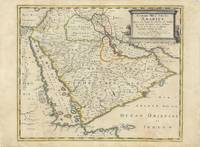
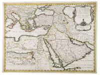
Arabia. Carte des Trois Arabies. Tirée en Partie de l'Arabe de Nubie en Partie de Divers autres Autheurs. . .
Paris Chez Pierre Mariette 1654. Original copper-engraved map of the Arabian Peninsula 43.5 x 59 cm with contemporary outline colour refreshed and adorned with a large columnar style title cartouche. A dark impression. Paper has been washed and strengthened due to foxing. Rare map of the Arabian Peninsula first published in 1654 and one of the first large maps focused specifically on the Arabian Peninsula. Sanson's map of the Arabian Peninsula continued to influence maps of the region throughout the latter part of the 17th century. Here Arabia is divided into three regions: Arabia Petraea the northwestern area encompassing the Sinai Peninsula and Jordan Arabia Deserta the northernmost area just south of the Tigris and Euphrates rivers and Arabia Felix by far the largest territory covering most of the peninsula and extending from the holy cities of Mecca and Medina in the northwest to the coasts of the Arabian Sea and the Gulf of Oman. There is great detail of mountains and rivers although there are clear geographical errors such as the exaggerated extent of the mountain ranges. Numerous villages are depicted including stopping places on the pilgrimage to Mecca Iathreb Badrahenen Gioffa and Cadaid among others as well as towns that appeared for the first time on a map of Arabia Hagair Hadrama Salamia and Iamama. Bahrain is demarcated along the northwestern shore of the Arabian Gulf. Nicolas Sanson was to bring about the rise of French cartography although the fierce competition of the Dutch would last until the end of the century. His success was partly owing to the partnership with the publisher Pierre Mariette. In 1644 the latter had purchased the business of Melchior Tavernier and helped Sanson with financial support in producing the maps. In 1657 Pierre Marriette died however his son also named Pierre co-published Les Cartes Générales de toutes les parties du Monde the following year. It was the first folio French produced world atlas. Tibbetts 98; Ankary p.98 Paris, Chez Pierre Mariette, 1654. unknown
Referenz des Buchhändlers : 62978
|
|
|
Sanson, Nicolas
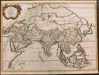
Asia Vetus Nicolai Sanson Christianiss Galliar Regis Geographi Recognita Emendata et Multis in locis Mutata Conatibus Geographicis Gulielmi
Paris: Pierre Mariette 1667. Very Good. Notes: An important map of Asia by Nicolas Sanson showing the boundaries of the major historic civilizations of this continent. Examples include Assyria Syria Asia Minor Armenia Arabia Felix Libya Sarmatia Thracia Graecia Persia India China Ethiopia Scythia and Gangem. <br><br>Sanson 1600–1667 was a French cartographer termed by some as the "father of French cartography." His works are known for their incorporation of the most up to date information of the time and their clean modern style. Size : 402x470 mm 15.83x18.50 Inches Coloring: Original Hand Coloring Category: Maps Asia Continent; Pierre Mariette unknown
Referenz des Buchhändlers : M8921
|
|
|
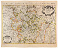
Sanson, Nicolaus
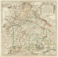
Bayern. Baviere. ou Sont les Duché Eslecrat et Palatnat De Baviere. Archevché De Saltzbourg: Evschés De Ratisbone Passau Freisingue et Aichstet. Palatinat De Neubourg Landgraviat de Leuchtemberg.1703
Paris 1703. Tadelloses Exemplar. 420 by 420mm 16½ by 16½ inches. Original antiker Kupferstich in zeitgenössischem Grenzkolrit. Dargestellt wird der bayrische Kreis um 1650 im Norden von Eger bis nach dem benachbarten Insbruck im Süden. Im Westen noch mit Ulm a.d. Donau und im Osten bis Linz. Die einzelnen Bezirksämter u. Bistümer deutlich durch das schöne Grenzkolorit herausgearbeitet. Zeigt Ober- u. Niederbayern sowie die Oberpfalz. Rechts oben große dekorative Rollwerkstitelkartusche links oben kleiner Meilenzeiger. Gestochen von R. Cordier. Nicolas Sanson der Ältere 20. Dezember 1600 in Abbeville Frankreich; † 7. Juli 1667 in Paris war ein französischer Kartograph. Seine Vorfahren stammten aus Schottland. In den Jahren 1618 bis 1667 schuf Sanson etwa 300 einzelne Karten sowie Atlanten und illustrierte Texte. Seine Arbeit wurde von seinen Söhnen Nicolas Sanson 1626 Schottland; † 27. August 1648 in Paris Adrien Sanson † 1708 und Guillaume Sanson † 1703 seinem Neffen Pierre Duval 1619; † 1683 seinem Enkel Pierre Moulard Sanson † 1730 und Gilles Robert de Vaugondy 1688; † 1766 fortgeführt. Wikipedia Speculum Orbis/Loeb San.VA53 unknown
Referenz des Buchhändlers : 32775
|
|
|
Sanson, Nicolas dAbbeville
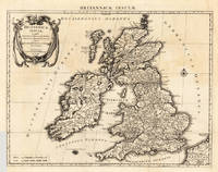
Britannicae Insulae in quibus Albium sive Britannia Maior Iuernia sive Britannia Minor tum et oOrcades Ebudes Cassiterides Autore N. Sanson. - Amstelodami Apud I. Covens & C. Mortier cum Privilegio.
Amsterdam: Covens 1696 -1700. Other. In very good to excellent condition. A small tear at the left side. 392 by 517mm 15½ by 20¼ inches. 392 by 517mm 15½ by 20¼ inches. Copper engraving uncolored as published. Covens unknown
Referenz des Buchhändlers : 23767
|
|
|
Sanson, Nicolas
Carte De LIsle De Sainct Christophle
Paris 1658. Very Good;. Notes: An early map of the Island of St. Christopher that includes a decorative compass rose in sea area and an ornamental title cartouche in top right decorated with scrolls ribbons and fruit. This is the first printed map of St. Kitts published in "Cartes Generales De Toutes Les Parties Du Monde."<br>With wide margins. Size : 314x429 mm 12.36x16.89 Inches Coloring: Original Outline Coloring cartouche and compass hand coloured Category: Maps West Indies Other Islands; unknown
Referenz des Buchhändlers : M7057
|
|
|
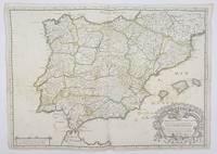
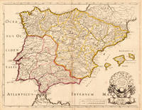
Sanson, Nicolas, mapmaker
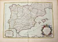
Carte Generale D'Espagne et de tous les Royaumes . . . Spain. Map
Paris.: Tavernier. 1658. Dampstain cover mot of the image also some coffee spots otherwise good. 42.5x57.2x.01 cm. Image size 41x55.5 to neatline. An uncommon map of Spain and Portugal with outline color. weight: 0.1 lb. Engraved by Melchior Tavernier. Tavernier. unknown
Referenz des Buchhändlers : 356952
|
|
|
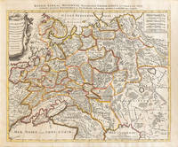
SANSON, Nicolas
Carte l'Empire de Russie Comprise en Europe Diviseé en ses Principaux Etats. Par Samson ! Ingeniere Geographe
Paris: Chez Jean Md d'Estampes 1812 Engraving 59 x 90 cm old color. The first edition of this map was published in 1674 by Hubert Jaillot under the title "La Russie Blanche ou Moscovie divisee suivant l'étendue des Royaumes Duches." It was incorporated into numerous atlases by Jaillot and his successors until approximately 1720 when it became evidently outdated. However around 1812 it was reissued likely to illustrate the French-Russian war. Chez Jean Md d'Estampes unknown
Referenz des Buchhändlers : 006820

|
|
|
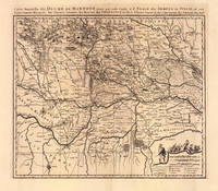
Sanson, Nicolas dAbbeville
Carte Nouvelle du Duché de Mantoue Leyée par ordre Exprés. á L´Usage des Armées en Italie; ou sont Exactement Marqués les Grands Chemins les Routes des Imperiaux &c. Par le Sr. Sanson. Geograp. du Roy á Amsterdam Chez P. Mortier Avec Privil.
Amsterdam: Pierre Mortier 1693-1700. Other. A strong impression in excellent condition. 490 by 580mm 19¼ by 22¾ inches. 490 by 580mm 19¼ by 22¾ inches. Copper engraving uncolored as published. Large detailed and interesting map by the famous French cartographer Nicolaus Sanson published in the famous sea atlas ‘Le Neptune francois.’ in Amsterdam at Pierre Mortier. This interesting and large map was originally first published in the ‘Atlas Noveau.’ by Alexis Hubert Jaillot & N. Sanson in Paris 1683-89. Alexis Hubert Jaillot & Nicolaus Jaillot worked as a royal cartographers for the French royal house for king Louis XIV. His maps published for the ‘Atlas Nouveau.’ can be regarded as masterpieces of cartography in France in the ending 18th century. Also the maps impress by their accuracy and are providing an enormous amount of place names monasteries rivers trails fortifications etc. Shown is the duchy of Mantua Mantova in Northern Italy. Mantua is shown prominently in the center of the map. The map provides many place names detailed information on the river system also in the lower right corner a cartouche with a mileage scale and a table of explanations. Pierre Mortier unknown
Referenz des Buchhändlers : 19103
|
|
|
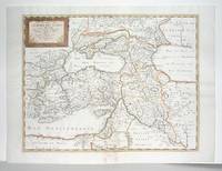
SANSON, Nicolas
Colchis Iberia Albania quaeg; Caucasiae Gentes Isthum qui Pontum Euxinum Caspiumq; Mare Interjacet Incolunt
Amsterdam: Mortier Pieter 1723. unbound. very good. Map. Engraving with hand outline. Image measures 14" x 18.75".<br/> <br/> Beautifully detailed map showing the area between the the Black and Caspian Seas including modern day Russia Georgia Azerbaijan Armenia and Turkey. Full original margins have minor stains. Based on the plates by Nicolas Sanson 1600-1667 who is considered the founder of the French school of cartography. In reaction to the prevailing trend of Dutch lavishness Sanson favored minimal details focusing rather on accurate cartography than ornament.<br/> <br/> Mortier, Pieter unknown
Referenz des Buchhändlers : 209708

|
|
|
Sanson, Nicolas; Jaillot, Alexis-Hubert
Comitatus Namurcensis cum Finitimis Regionibus ad Usum Serenissimi Burgundiae Ducis
Amsterdam: Pierre Mortier 1710 Cooper engraving 50.5 x 60.5 cm on paper measuring 54.0 x 63.0 cm with original color in outline minor spotting and creasing remnants of centerfold paper slightly frayed at edges. A good copy of an uncommon map of the province of Namur a region of the Spanish Netherlands published in Amsterdam by Pierre Mortier to illustrate events of the War of the Spanish Succession. Pierre Mortier unknown
Referenz des Buchhändlers : 009138
|
|
|
Sanson, Nicolas d'Abbeville
Duche et Gouvernement de Normandie
Paris 1650. No Binding. Very Good/No Jacket. R Cordier. 1650 Normanie. Engraved by R Cordier. A fine and detailed province map with the english coast included. All important place names are shown. Original outline colour. very slight discoloration. otherwise good condition. 385 x 515 mm framed and glazed <br/> <br/> unknown
Referenz des Buchhändlers : 011592
|
|
|
SANSON, Nicolas.
ESPAGNE.
Nicolas Bion: L'Usage des Globes. Amsterdam: Francois Halma. 1700. Attractive map of Spain divided into its provinces. Maps by Sanson in original colour are rare. Nicolas Sanson was founder of the French school of mapmakers at a time when the leadership in European cartography passed from the Low Countries to France. This map was published in Brion's treatise on globes. Nicolas Brion was a famous French mathematical and scientific instrument maker. Copper engraving. Fine condition. Original colour. Size: 23.5 x 18 cm. 9½ x 7 inches. unknown
Referenz des Buchhändlers : 54030

|
|
|
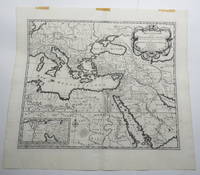
SANSON, Nicolas.
Estats de L'Empire du Grand Seigneur des Turqs ou Sultan des Ottomans en Asie en Afrique et en Europe.
Paris 1654. Engraved map 42 x 56 cm coloured in outline. Map of the Turkish Empire showing Ottoman possessions in the Balkans Eastern Mediterranean Egypt and Arabia - marking topography and settlements.l Al Ankary 59; Al-Qasimi 60; Tibbetts 99. unknown
Referenz des Buchhändlers : G1ADV7RKD7B6
|
|
|
SANSON, Nicolas.
ESTATS et ROYAUMES de FEZ et MAROC DARHA et SEGELMESSE; Tires de Sanuto de Marmol &c.
Paris. 1655. Attractive map of Morocco and parts of Algeria. Maps by Sanson in original colour are rare. Nicolas Sanson was founder of the French school of mapmakers at a time when the leadership in European cartography passed from the Low Countries to France. Copper engraving. Very good condition. Some light browning to the centre fold. Attractive water mark. Original colour. Size: 53 x 40 cm. 21 x 15½ inches unknown
Referenz des Buchhändlers : 56109

|
|
|
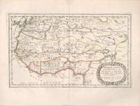
SANSON, Nicolas
Galatia cujus Populi Tolistobogi Tectosages Trocmi mox Provincia sub Romanis in Primam et Secundam divisa et in ea Romana Itineraria
Amsterdam: Pierre Mortier. unbound. very good. Map. Engraving with hand outline. Image measures 13 3/4" x 22 1/2".<br/> <br/> Rare map of Galatia an ancient region of northern Anatolia present-day Turkey along the southern coast of the Black Sea. Published circa 1705 this map is centered on Ankara and shows provinces inhabited by Trocmi Tectosages and Tolistobogi - three Celtic tribes who inhabited the region from the 3rd century BC. Neighboring historical regions of Paphlagonia Pontus Phyrgia Cappadocia and Lycaonia are labeled. Mountains and cities are depicted pictorially. The map shows major roads connecting cities throughout the region. A decorative cartouche features lively figures celebrating with percussion and wind instruments. Full original margins minor offsetting. Based on earlier plates by Sanson. This map appeared in "Atlas Antiquus Sacer Ecclesiasticus et Profanus" published in Amsterdam by Pieter Mortier. <br> <br> Nicolas Sanson 1600-1667 who is considered the founder of the French school of cartography. In reaction to the prevailing trend of Dutch lavishness Sanson favored minimal details focusing rather on accurate cartography than ornament. <br> Pierre Mortier 1661-1711 was a Dutch cartographer engraver and printseller who worked in Amsterdam. He used advanced Dutch printing methods to produce high quality editions of contemporary French maps by cartographers such as De L'Isle Sanson Jaillot de Fer and De Wit. This map is a lovely example of his work.<br/> <br/> Pierre Mortier unknown
Referenz des Buchhändlers : 215370

|
|
|
Sanson, Nicolas d'Abbeville
Geographia Synodica Sive Regionum Urbium et Locorum vbi Celebrata sunt Concilia Oecumenica Nationalia Provincialia et Synodi Diocesanae Tabula Geographica Secunda Italiam Galliam et Angliam Exhibens Ex Conatibus Geographicis.
Paris 1667. Excellent. Size : 424x563 mm 16.625x22.125 Inches Coloring: Original Outline Coloring Category: ; Maps Europe France; Maps Europe Italy unknown
Referenz des Buchhändlers : M2849
|
|
|
SANSON, NICOLAS - THE PALESTINE ATLAS.
Geographia Sacra et veteri et novo testamento desumata et in Tabulas quatuor concinnata: quarum I. Totius orbis in Bibliis Sacris cogniti partes continet: II. Terram promissam sive Judaeam in suas tribus divisam: III & IV. Jesu Christi & Apostolo.
Amsterdam Franciscus Halma 1704. Folio. 455 x 29 cm. Contemp. full blindtooled Dutch vellum. Raised bands. Spine ends with tears some cracking along fronthinge but not loose. Vellum at frontcover a bit soiled. Egraved titlepage Coxis del. ianen fecit. Printed titlepage in red/black with an engraved vignette. 15119511 pp. 1 engraved plate with portrait and coat of arms. 4 large folded engraved maps. Light yellowing to margins of textleaves but maps and text fine and clean. 3 of the maps engraved by F. Halma. <br/><br/><em>The maps are the Francois Halma reissues of Sanson's maps from 1683. </em> hardcover
Referenz des Buchhändlers : 48770
|
|
|
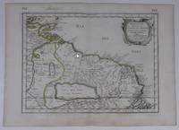
SANSON, Nicolas.
Guiane
Paris. c1657. A very attractive and finely engraved map of the north eastern South American country of Guiana. The map is highlighted by numerous rivers tributaries mountains villages inlets bays and a very large inland equatorial lake that was thought to exist. Published in "Cartes Generales de toutes les parties du monde." Size: 285 x 360 mm. Copperplate engraving with original outline colouring. Fine condition. unknown
Referenz des Buchhändlers : 66689
|
|
|
SANSON, Nicolas.
Guiane divisée en Guiane et Caribane.
Paris Pierre Mariette 1656. Engraved map of Suriname coloured in outline with fine cartouche. Ca. 245 x 345 cm. A reduced derivative of the famous Sanson map of 1650 published in an early edition of the small Sanson atlas L'Europe Dediée a Monseigneur . . . Le Tellier Secret. D'Estat &c. Engraved by A. Peyrounin. unknown
Referenz des Buchhändlers : #[37942]
|
|
|
SANSON, Nicolas.
GUIANE divisee en guiane et Caribane.
Nicolas Bion: L'Usage des Globes. Amsterdam: Francois Halma. 1700. Map showing north-east South America from Trindad to the mouth of the Amazon - modern day Guyana and Surinam. Several large fictitious lakes make up much of the unexplored interior. Maps by Sanson in original colour are rare. Nicolas Sanson was founder of the French school of mapmakers at a time when the leadership in European cartography passed from the Low Countries to France. This map was published in Bion's treatise on globes. Nicolas Bion was a famous French mathematical and scientific instrument maker. Copper engraving. Very good condition. Small 1cm. very faint library stamp on border not affecting map. Original colour. Size: 27.5 x 20 cm. 11 x 8 inches. unknown
Referenz des Buchhändlers : 54043

|
|
|
Sanson, Nicolas dAbbeville
Hispaniae Antiquae Tabula. Authore N. Sanson Christianiß. Gall. Regis Geographo A. 1704. Apud Autorem in Aedibus Regiis Chez le Sr. Sanson Aux Galleries du Louvre. Avec Privilege du Roy.
Paris: N. Sanson 1704. Other. In very good condition a slightly creasing in the lower part of the centrefold with minor tiny spots. 410 by 525mm 16¼ by 20¾ inches. 410 by 525mm 16¼ by 20¾ inches. Copper engraving hand colored in outline when published. Interesting and detailed map of ‘Antique SpainÂ’ with Portugal and the Balearic Islands by the French cartographer Nicolaus Sanson d´Abbeville. The map provides us a lot of information of the various place names of cities and small towns the rivers mountains and also engraved borders of the various Spanish provinces. The map impresses with the geographic exactness which is typical for the French cartographer Nicolaus Sanson. In the decorative cartouche which is in shape of a seashell we find the altered date ‘1704Â’ which is a relatively late edition for maps by N. Sanson. The map is probably published in a French composit atlas around this date. N. Sanson unknown
Referenz des Buchhändlers : 19604
|
|
|
Sanson, Nicolas
In Pharum Galliae Antiquae Philippi Labbe Biturici Et Societatis Iesu Sacerdotis Disquisitiones Geographicae 1647 Latin Edition
Kessinger Publishing 17-07-2009. paperback. New. 6.00x0.56x9.00. Buy with confidence. Excellent Customer Service & Return policy. Kessinger Publishing paperback
Referenz des Buchhändlers : DADAX1104771187 ISBN : 1104771187 9781104771188
|
|
|
Sanson, Nicolas
In Pharum Galliae Antiquae Philippi Labbe Biturici Et Societatis Iesu Sacerdotis Disquisitiones Geographicae 1647 Latin Edition
paperback. Good. Access codes and supplements are not guaranteed with used items. May be an ex-library book. paperback
Referenz des Buchhändlers : 1104771187.G ISBN : 1104771187 9781104771188
|
|
|
Sanson, Nicolas
In Pharum Galliae Antiquae Philippi Labbe Biturici Et Societatis Iesu Sacerdotis Disquisitiones Geographicae 1647 Latin Edition
paperback. Good. Access codes and supplements are not guaranteed with used items. May be an ex-library book. paperback
Referenz des Buchhändlers : 1166040631.G ISBN : 1166040631 9781166040635
|
|
|
Sanson, Nicolas#11;#11;
In Pharum Galliae antiquae Philippi Labbe Biturici & Societatis Iesu Sacerdotis disquisitiones geographicae : in quibus ad singula omnium locorum nomina aut furti sive plagii aut falsi sive erroris arguitur Philip. Labbe
Lutetiae Parisiorum: Sumptibus & Impensis Autoris 1647. Hardcover. Good. 16mo. Old leather; quite worn. pp 16 246 2. Liber primus only. <br/><br/> Sumptibus & Impensis Autoris hardcover
Referenz des Buchhändlers : WB16371
|
|
|
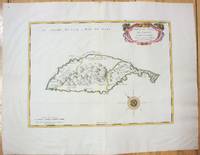
SANSON, Nicolas
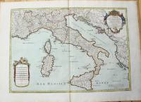
Isle et Royaume de Sicile
Paris 1663. unbound. very good. Map. Hand-colored engraving. 15" x 23".<br/> <br/> This map of Sicily from the 17th century shows the entire island as well as the southwesternmost tip of the Italian peninsula. The names of the surrounding bodies of water are named in Latin and rivers mountains lakes and towns are noted on the map. <BR> <BR> Nicolas Sanson 1600-1667 is considered the founder of the French school of cartography. In reaction to the prevailing trend of Dutch lavishness Sanson favored minimal details focusing rather on accurate cartography than ornament. This map is a fine example of his work.<br/> <br/> unknown
Referenz des Buchhändlers : 283501

|
|
|
Sanson, Nicolas
L'Afrique en Plusieurs Cartes Nouvelles et Exactes; & en Divers Tractes de Geographie et d'Histoire. . .
Paris: Chez l'Autheur 1656. First Edition. Full Calf. Very Good. 4to. 23.5 by 17.5 cm. Unpaginated 100 pages of text plus 2 pp. of ads. With 18 copper engraved maps all two page plates each with hand-colored of boundaries. Maps include one of the entire continent then of its various regions as then known plus the islands off the continent. Also a map of Malta. Bound in contemporary calf. Condition: calf dry and rubbed on spine and joints and edges rubbed. Light to moderate soiling in the margins of the pages. Two bookplates -- one of the Marquis of Lothian the other the Newbattle Abbey Library. Chez l'Autheur unknown
Referenz des Buchhändlers : 006682

|
|
|
Sanson, Nicolas
L'Asie En Plusieurs Cartes Nouvelles Et Exactes Et En Divers Traittés de Géographie Et d'Histoire French Edition
paperback. Good. Access codes and supplements are not guaranteed with used items. May be an ex-library book. paperback
Referenz des Buchhändlers : 2016172495.G ISBN : 2016172495 9782016172490
|
|
|
Sanson, Nicolas
L'Asie en Plusieurs Cartes Nouvelles et Exactes; & en Divers Tractes de Geographie et d'Histoire. . .
Paris: Chez l'Autheur 1652. First Edition. Full Calf. Very Good. 4to. 23.5 by 17.5 cm. Unpaginated 102 pages of text plus 2 pp. of ads 1 Royal privilege page. With 17 copper engraved maps all two page plates each with hand-colored of boundaries. Maps include one of the entire continent then of its various regions as then known plus island groups. Separate maps for China and Japan. Bound in contemporary calf. Condition: Rebacked with joints making this obvious. The original spine was re-mounted with some losses. Its blindstamped decoration of fans is discernible but somewhat vague. We think it is possible this decoration had some gilding or color originally but none survives. Still an interesting and unusual feature in our view. Calf dry and rubbed on spine and joints and edges rubbed. Light to moderate soiling in the margins of many pages and on a few pages the soiling invades inward beyond the margins and also in a few instances the marginal soiling is on the heavier side. There are a few archival tape repairs of small chips three on the title leaf one on the following leaf and after that wormhole edge damage was left untouched. That said the defect and repair isn't as glaring as it might sound. The edges elsewhere can have short spans of a chewed appearance. As a book generally we would consider this copy at best Good. As far as the maps go independent of the book we would regard them as Very Good. A few of the maps might individually fall short of such grading; on the other hand all the maps of this copy one can easily imagine someone enthusiastically framing even without an attempt to clean them up. Two bookplates -- one of the Marquis of Lothian the other the Newbattle Abbey Library. Chez l'Autheur unknown
Referenz des Buchhändlers : 006683

|
|
|
Sanson, Nicolas d'Abbeville - Jaillot, Hubert
L'Espagne divisee en tous ses Royaumes Et Principautes suivant quils sont compris sous Les Couronnes de Castille et D'Aragon.
Paris: H. Jaillot c.1710. Very Good. Size : 465x655 mm 18.31x25.79 Inches Coloring: Original Hand Coloring Category: Maps Europe Portugal; Maps Europe Spain; H. Jaillot unknown
Referenz des Buchhändlers : M10278
|
|
|
Sanson, Nicolas
L'Europe Dediée a Monseigneur Le Tellier Secret d'Estat French Edition
paperback. Good. Access codes and supplements are not guaranteed with used items. May be an ex-library book. paperback
Referenz des Buchhändlers : 232929400X.G ISBN : 232929400X 9782329294001
|
|
|
Sanson, Nicolas
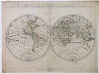
L'Hydrographie Ou Description De L'Eau C'Est a Dire Des Mers Golfes Lacs Destroits Et Rivieres Principales Qui Font Dans La Surface Du Globe Terrestre
Paris: Sanson. Very Good. 1652. A very rare map from Nicolas Sanson. Imprint bears the date of 1652 although it is possible that this copy came from an atlas in the later 1600s. Light toning and edgewear with one corner slightly chipped. Light soil on lower margin. Hand-colored boundaries. Map borders measure 14" x 20 3/4". California is shown as an island and Terre Australe is a vague line encircling the Antarctic. Terre de Iesso is the name given to the land mass northwest of North America. Sanson 1600-1667 published many map versions of the world and is known as "the father of French cartography." ; 16 1/2" x 22 1/4" . Sanson unknown
Referenz des Buchhändlers : 010748tw
|
|
|
Sanson, Nicolas d'Abbeville - Jaillot, Hubert
L'Italie distinguee suivant l'estendue de tous Les Estats Royaumes Republiques Duches Principautes &c.
Paris: H. Jaillot c.1783. Very Good. Size : 469x655 mm 18.46x25.79 Inches Coloring: Original Hand Coloring Category: Maps Europe Italy; Maps Mediterranean Islands; H. Jaillot unknown
Referenz des Buchhändlers : M10279
|
|
|
Sanson, Nicolas; Jaillot, Alexis-Hubert
La Lorraine qui Comprend Les Duches de Lorraine et de Bar et les Balliages des Evesches et des Villes de Metz Toul et Verdun
Amsterdam: Pierre Mortier 1710 Cooper engraving 46.5 x 61.5 cm on paper measuring 54.0 x 64.5 cm with original color in outline minor spotting and creasing remnants of centerfold. A good copy of a map of the Duchy of Lorraine and surrounding territories published in Amsterdam by Pierre Mortier to illustrate events of the War of the Spanish Succession. Pierre Mortier unknown
Referenz des Buchhändlers : 009140
|
|
|
Sanson, Nicolas
La Russie Blanche ou Moscovie Divisée Suivant l'Estendue Des Royaumes Duches Principautes Provinces et Peuples
Amsterdam: Petrus Schenck 1710 Cooper engraving 46.5 x 58.0 cm on paper measuring 51.0 x 63.5 cm with original outline coloring flattened expertly restored and backed with archival tissue paper. The Latin title in the top border reads: "Russiae Albae sive Moscoviae delineatio Geographica accurata et nova…". A good copy of a Moscovie map published in Amsterdam by Petrus Schenck. Petrus Schenck unknown
Referenz des Buchhändlers : 009147
|
|
|
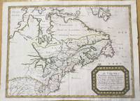
Sanson, Nicolas d'Abbeville
Le Canada ou Nouvelle France &c. Ce qui est le plus advance vers le Septentrion est tire de diverses Replations des Anglois Danois &c. Vers le Midy les Costes de Virginie Nouv.lle Suede Nouveau Pays Bas et Nouvelle Angleterre Sont tirees de celles des Anglois Hollandois &c. La Grande Riviere de Canada ou de St Laurens et tous les environs sont suivant les Ralations des Francois.
Paris: Mariette Pierre c.1656. Very Good. Notes: "Nicolas Sanson's 1600-1667 involvement in cartography began with the maps and illustrations he drew for publication in his own historical books. Nicolas Sanson was the outstanding French cartographer of the mid to late seventeenth century and is considered the founder of the French school of cartography. Due largely to the Sanson family map-publishing business the patronage of Louis XIV and the work of the newly-formed Académie royale des sciences the seat of cartography shifted from the Low Countries to France in the latter part of the seventeenth century. "This folio map by Sanson published in 1656 influenced the cartography for the next fifty years. The eastern Great Lakes region is remarkably accurate with the western ends of the lakes undefined for lack of reliable information. The possibility of a northwest passage at the bottom of Button's Bay was also to influence a considerable number of cartographers for the rest of the century" -Kershaw "This is the most influential record of the French establishments in North America in the middle of the seventeenth century. It is based on the Jesuit Relations and shows an accurate course of the St. Lawrence and the Great Lakes in more or less their proper locations. Another source was Sanson's own map of North America published in 1650. "The discoveries and observations of Samuel de Champlain and the Jesuit fathers Jogues and Raymbault are shown as well as much information gleaned from the reports of the many fur-traders in Canada at the time together with hearsay information supplied by travellers among the Indians. Note however the unusual orientation of Lake Michigan probably gathered from Bartheemy Vimont's travels of 1642 in an east to west direction along the northern shores of the lake. Many other names here are Indian in origin." -Goss " Size : 405x540 mm 15.94x21.26 Inches Coloring: Hand Colored Reference: Kershaw 133; Goss The Mapping of North America map 33; Karpinski X & Plate III; Kaufman # 3; Armstrong # 10; Cumming # 48 & Plate 30; Schwartz & Ehrengerg p.114 Category: Maps Canada; Maps Canada East; Maps North America Great Lakes; Mariette, Pierre unknown
Referenz des Buchhändlers : M9956
|
|
|
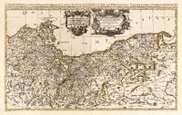
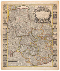
Sanson, Nicolas dAbbeville
Le Duche de Pomeranie divisé en ses Principales Parties Dressè sur les Memoires les plus Nouveaux. Par le Sr. Sanson. Geographe Ordinaire du Roy. A Paris Chez H Iaillot. joignant les grands Augustins aux deux Globes Avec Privilege du Roy Pourvingt Ans 1696.
Paris: Hubert Jaillot 1696. Other. In excellent condition. 545 by 874mm 21½ by 34½ inches. 545 by 874mm 21½ by 34½ inches. Copper engraving hand colored in outline when published. This is the very large and detailed map of the duchy of Pommerania by the famous French cartographer Nicolaus Sanson. It shows Pommerania newly divided up into its primary principalities with the neighboring duchy of Prussia and parts of the kingdom of Poland. The map is printed from two large plates and was for the first time published with Nicolaus Sanson in Paris 1696. The map provides very detailed information on geographical place names rivers mountains and political borders. Nicolaus Sanson Hubert Jaillot’s map of Pommerania can be treated as a masterpiece of the French baroque cartography in the 17th century. It took Nicolaus Sanson and Hubert Jaillot a period of about fifteen years to complete this enormous work c. 1681-96. The atlas was dedicated to Ludwig XIV. Hubert Jaillot unknown
Referenz des Buchhändlers : 25836
|
|
|
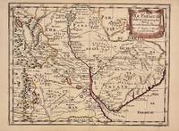
SANSON, Nicolas
Le Paraguay
Paris 1657. unbound. Map. Original outline coloring. Sheet measures 8 3/4" x 12 1/8". Image measures 8" x 10 5/8". Paris: Nicolas Sanson 1657.<br/> <br/> This rare 17th century map by Nicolas Sanson with original color depicts the region showing present day Paraguay Uruguay with parts of Brazil and Argentina. Mountains are rendered pictorially and cities rivers and notations describing indigenous populations are labeled. In very good condition.<br> <br> Nicolas Sanson 1600-1667 is considered the founder of the French school of cartography. In reaction to the prevailing trend of Dutch lavishness Sanson favored minimal details focusing rather on accurate cartography than ornament.<br/> <br/> unknown
Referenz des Buchhändlers : 326341
|
|
|
SANSON, Nicolas.
LE PARAGUAY.
Histoire et Geographie de l'Amerique. 1657. Attractive map of Paraguay. Title cartouche at top right. Maps by Sanson in original colour are rare. Nicolas Sanson was founder of the French school of mapmakers at a time when the leadership in European cartography passed from the Low Countries to France. Copper engraving. Fine condition; very light offsetting. Original outline colour. Size: 28.5 x 21.5 cm. 11 x 8½ inches unknown
Referenz des Buchhändlers : 56721

|
|
|
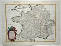
Sanson, Nicolas d'Abbeville
Le Royaume de France et ses Acquisitions vers les Pays Bay L'Allemagne L'Italie et L'Espagne.
Paris: Mariette Pierre 1665. Excellent; some light browning on upper margin. Size : 410x535 mm 16.125x21 Inches Coloring: Original Hand Coloring Category: ; Maps Europe France Mariette, Pierre unknown
Referenz des Buchhändlers : M1736
|
|
|
Sanson, Nicholas.
Le Royaume De France divise en Toutes fes Provinces…
<p>Copper engraved map double page 24" x 20" hand colored and large uncolored title cartouches. Some minor soiling a little wear along centerfold with old verso repair normal aging; very good. Samson 1600-1667 is often referred to as the father of French cartography. Louis XIII was impressed with his work and appointed him "Geographe Ordinaire du Roi". During his career Sanson would produce about 300 maps and his major atlas "Cartes Generales de Toutes les Parties du Monde" would represent an important part of his body of work. While two of his sons continued publication of his maps after his death Pieter Schenk 1655-1718 an important publisher and engraver in his own right published this map. The map is attractively colored and gives a detailed view of the provinces of France. The map is also decorated with a large title cartouche. Bagrow p. 185. map hist website.</p>
Referenz des Buchhändlers : 104160

|
|
|
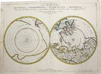
Sanson, Nicolas d'Abbeville
Les Deux Poles Arctique ou Septentrionale et Antartique ou Meridional ou description des Terres Arctiques et Antartiques; et des pays circomvoisins jusques aux 45 Degrees de Latitude.
Paris 1657. Very Good; some occasional mild browning. Notes: 17th century French map of Arctic and Antarctic regions. It was published in Cartes générales de toutes les parties du monde. <br><br>Nicolas Sanson 1600–1667 was a renowned French cartographer termed by some as the "father of French cartography." His works are known for their incorporation of the most up to date information of the time and their clean modern style. Size : 390x537 mm 15.375x21.125 Inches Coloring: Hand Colored in outline Category: ; Maps Polar Arctic Regions; Maps Polar Antarctic Regions unknown
Referenz des Buchhändlers : M954
|
|
|
SANSON, NicolasEngraved by SOMER, Jean. s. En
LES DEUX POLES.
Paris: Chez Pierre Mariette. 1655. An attractive double hemisphere map based on the polar projections so as to include the northern and southern thirds of the world. The North pole is connected to Greenland and Spitzbergen but there is little other detailed coastline in the polar area. Europe Russia and Canada are delineated. The South pole is based on the great unknown Southland of Magellan. The tip of S. America is shown and a large land mass which encompasses the whole of the hemisphere but nothing else showing the limited extent of knowledge of these extreme latitudes. Extraordinarily enough though the southern projection which shows little more than the outline of a vast landmass 'Australe et Incogneue' roughly corresponding to Antarctica as we know it today long before any of it was discovered. Maps by Sanson in original colour are rare. Nicolas Sanson 1600-1667 French cartographer who established the first great cartographic dynasty in France. He was tutor to Louis XIV. Sanson published over 300 maps and was a founder of the French school of mapmakers at a time when the leadership in European cartography passed from the Low Countries to France. Copper engraving. Very good condition; some browning to the centrefold and a stain to the upper left not affecting the image. Original colour. Size: 54 x 39 cm. 21½ x 15½ inches unknown
Referenz des Buchhändlers : 56271

|
|
|
Sanson, Nicolas; Jaillot, Alexis-Hubert
Les Estats de Savoye et de Piemont presenté à Monseigneur le duc de Bourgogne
Amsterdam: Pierre Mortier 1710 Cooper engraving 58.0 x 50.5 cm on paper measuring 63.0 x 54.0 cm with original color in outline minor spotting and creasing remnants of centerfold paper slightly frayed at edges. A good copy of an uncommon map of Savoy and Piedmont published in Amsterdam by Pierre Mortier to illustrate events of the War of the Spanish Succession. Surrounded by twenty-two coats of arms representing various provinces. Pierre Mortier unknown
Referenz des Buchhändlers : 009139
|
|
|
Sanson, Nicolas d'Abbeville
Les Estats de l'Empire des Turqs en Asie
Paris: Mariette Pierre 1660. Very Good; some browning on the lower margin near the fold. Size : 407x517 mm 16x20.375 Inches Coloring: Hand Colored Category: ; Maps Mediterranean Sea; Maps Asia Near East Turkey; Mariette, Pierre unknown
Referenz des Buchhändlers : M2926
|
|
|
SANSON, Nicolas
Les Suisses les Allies des Suisses et leurs Suiets; qui peuvent passer Sous le mon de Suisses. Partie de Souabe &c
Paris 1648. unbound. Map. Engraving with hand outline color. Image measures 14.5 x 21.5 inches.<br/> <br/> This map of Switzerland centers on Lucerne covering approximately the area from Lake Constance south to Lake Como in Italy. Published in 1648 the map dates to the period of the Old Swiss Confederacy. Furthermore it predates by only a few years the Swiss Peasant War of 1653 a siege of Lucerne and Bern that demonstrated the significance of the rural population to the confederacy's stability. Hand-colored outlines on the map indicate the various independent states that made up the confederacy. A title cartouche with elaborate scrollwork adorns the lower right corner of the map. The map is in good condition with full margins and no chips or tears. Wear to lower margin. <br> <br> Nicolas Sanson 1600-1667 is considered the founder of the French school of cartography. In reaction to the prevailing trend of Dutch lavishness Sanson favored minimal details focusing rather on accurate cartography than ornament. This map demonstrates the skill that made him such a valuable asset to the French monarchy.<br/> <br/> unknown
Referenz des Buchhändlers : 251162

|
|
|
Sanson, Nicolas:
LEmpire du Grand Mogol
Amsterdam c. 1690. Copper engraving 19.2 x 24.5 cm modern hand colour blank verso. Sansons small map of the Mughal Empire was published in his 1652 atlas of Asia L'Asie en plusieurs cartes nouvelles et exactes. The date privilege and name of the engraver were omitted from later states of the plate but our example appears to be a Dutch version re-engraved for Francois Halmas Description de tout l'Univers. Nicolas Sanson 1600-1667 founder of the Sanson dynasty of map-makers is considered by many to be the father of the French school of cartography. He was a prolific and original map-maker admired for the clarity and scientific accuracy of his maps. Map unknown
Referenz des Buchhändlers : 9797
|
|
|
Sanson, Nicolas
Map - Mediterranean Description de la Geographie Sacree - Tiree du Vieux & du Nouveau Testament qui Contient les Parties de Tout le Monde. Par N. Sanson
Amsterdam: Pierre Mortier. Very Good with No dust jacket as issued. c.1707. Map. 3 pieces of brown paper tape along upper blank margin.; No date c. 1707. We think this map is possibly from "Le Sainte Bible" edited by David Martin Amsterdam 1707. Dimensions of sheet: 508 x 451mm. Dimensions of printed area: 439 x 368mm. Uncoloured. Copperplate engraved map. Elaborate cartouche. Centrefold. With inset map at lower left "Campemens des Israelites dans le Desert". "The first Pieter Mortier was an 18th-century mapmaker and engraver who was born in Leiden the son of a political refugee from France. He travelled to Paris in 1681-1685 then returned to Amsterdam where he operated as a bookseller from 1685 until 1711. He won the privilege in 1690 of publishing maps and atlases by French publishers in Amsterdam for the Dutch market. He used this privilege to win a similar set of privileges for printing an "illustrated print bible" in 1700." - Wikipedia entry on Pieter or Pierre Mortier accessed October 2021. NB: This map will be posted rolled in a mailing tube. . Pierre Mortier unknown
Referenz des Buchhändlers : 23156
|
|
|
Sanson, Nicholas (French, 1600-1667).
Map of Afrique ou Librie Ulterieure ou sont La Saara ou Desert Le Pays des Negres La Guinee &c.
Paris: Nicholas Sanson 1656. Hand colored engraving. 18.5 x 29.7 cm. plate. Very Good folded in center. Paris: Nicholas Sanson, 1656. unknown
Referenz des Buchhändlers : 71-2849
|
|
|
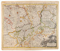
Sanson, Nicolas
MAP OF RHINE AREA Table geographique dans la quelle fort distinctement est montre la partie meridionale ou superieure du Rhein Meuse Moselle et les moindres rivieres . et la Comte de Bourgogne et d'autres provinces.
Paris Alexis Hubert Jaillot 1700. One sheet ink on paper. Copper engraving. Hand painted. Good condition. The map depicts the upper and lower Rhine region from Metz in the north to Lake Como in the south and Dijon in the west to Augsburg in the east. On the left hand side is the legend with miles to Italian French and German miles. In passepartout total size 650 x 750 mm. unknown
Referenz des Buchhändlers : 61441

|
|
 Per e-mail erhalten
 Als pdf-Dokument herunterladen
 RSS feed


