|
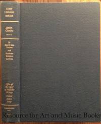
Army Lineage SeriesOffice Chief Milit. Hist
ARMOR-CAVALRY- PART 1: REGULAR ARMY AND ARMY RESERVE
Government Printing Office. Used - Acceptable. Acceptable condition. Book Good. No dust jacket. Gifter's inscription on endpage. Government Printing Office unknown
Riferimento per il libraio : P09K-00960
|
|
|
Army Lineage SeriesOffice Chief Milit. Hist
ARMOR-CAVALRY- PART 1: REGULAR ARMY AND ARMY RESERVE
Government Printing Office 1969 2019-08-22. Hardcover. Good. Buckling/warping to pages tight binding solid hinges light rubbing to corners. Government Printing Office hardcover
Riferimento per il libraio : 161211014
|
|
|
ARMY LIST
A list of the officers of the army and of the corps of royal marines on full retired and half-pay.Corrected throughout to the 31st March 1854. 1854-55
London: Printed By George E. Eyre and William Spottiswoode 1854. 4 643pp 1. Original publisher's red blind-stamped cloth lettered in gilt. A trifle rubbed lightly marked spine sunned corners bumped. Internally clean and crisp recent armorial bookplate to FEP of Ceftilla. The army list for 1854 from the library of the Raglan baronetcy which gives mention to Lieutenant-General Fitz-roy James Henry Lord Raglan who in that year led the fateful Charge of the Light Brigade during the Crimean War. He would die during the Siege of Sevastopol just a few months later in 1855. Following the death of the 1st Baron Raglan 1788-1855 commander of allied forces during the Crimean War 1623 of his friends admirers and comrades purchased the estate of Cefntilla Court in Monmouthshire Wales presenting the home to Richard Somerset 2nd Baron Raglan 1817-1884 and his heirs in perpetuity as a memorial in remembrance of his father's contribution to the British military. . First edition. Large 8vo. Printed By George E. Eyre and William Spottiswoode hardcover
Riferimento per il libraio : AQ13093

|
|
|
ARMY LIST
List of the General and Field-Officers as they Rank in the Army; of the officers in the several regiments of Horse Dragoons and Foot on the British and Irish establishments with the dates of their commissions as they rank in each corps and as they rank in the army : the Royal Regiment of Artillery Irish Artillery Engineers the Marines and independent companies : governors lieutenant-governors of His Majesty's garrisons at home and abroad with their allowances and the officers on half-pay &c. : to which is now added the succession of colonels
London: Printed for J. Millan 1765. 8v0 205 x 130mm 6 1-52 56-91 93-168 132-151 149-152 5-20 12 2pp. lacks front endpaper ex-ministry of Defence Library text browned cont. calf rubbed joints cracked. At head of title: 'By permission of the Right Honourable the Secretary at War'; the list of garrisons is paginated 132-152 5-20; with a final leaf of 'Additions since printing'. Early ownership signature of Frederick Charles Mackenzie and W. Abercromby. London: Printed for J. Millan, [1765] unknown
Riferimento per il libraio : 37655
|
|
|
ARMY LIST
List of the General and Field-Officers as they Rank in the Army; of the officers in the several regiments of Horse Dragoons and Foot on the British and Irish establishments with the dates of their commissions as they rank in each corps and as they rank in the army : the Royal Regiment of Artillery Irish Artillery Engineers the Marines and independent companies : governors lieutenant-governors of His Majesty's garrisons at home and abroad with their allowances and the officers on half-pay &c. : to which is now added the succession of colonels
London: Printed for J. Millan 1763. 8vo 210 x 130mm 18 13-48 52-91 93-140 133-148 12 2pp. interleaved throughout with blank pages ex-ministry of Defence Library cont. calf rubbed and worn leather peeled away from boards joints cracked. Annual Army list to November 1763. The pagination of this book is erratic to say the least: there are no pages 49 50 or 51 page 52 follows p. 48 from thence onwards to p. 91 38th Foot inclusive all the odd numbers are on the verso side there is no page 91 page 93 39th Foot follows p. 91 and from thence to p. 140 the pagination is normal a page numbered 133 70 Companies of Marines follows p. 140 and this continues to p. 148 thence follows 12 pages succession of Colonels and a final leaf Additions since Printing. It seems the printer who set up this list must have been a 'Dreamer'. ESTC N62475 locates a single copy of this edition at the National Archives. London: Printed for J. Millan, [1763] hardcover
Riferimento per il libraio : 37656
|
|
|
ARMY LIST
List of the General and Field-Officers as they Rank in the Army; of the officers in the several regiments of Horse Dragoons and Foot on the British and Irish establishments with the dates of their commissions as they rank in each corps and as they rank in the army : the Royal Regiment of Artillery Irish Artillery Engineers the Marines and independent companies : governors lieutenant-governors of His Majesty's garrisons at home and abroad with their allowances and the officers on half-pay &c. : to which is now added the succession of colonels
London: Printed for J. Millan 1763. 4to 275 x 195mm 18 13-48 52-91 93-140 133-148 12 2pp. LARGE PAPER COPY in addition there are two final leaves with manuscript additions for the 32 Regiment of Foot and the 36 Regiment of Foot later half calf rubbed lacks spine covers detached. Annual Army list to November 1763. The pagination of this book is erratic to say the least: there are no pages 49 50 or 51 page 52 follows p. 48 from thence onwards to p. 91 38th Foot inclusive all the odd numbers are on the verso side there is no page 91 page 93 39th Foot follows p. 91 and from thence to p. 140 the pagination is normal a page numbered 133 70 Companies of Marines follows p. 140 and this continues to p. 148 thence follows 12 pages succession of Colonels and a final leaf Additions since Printing. It seems the printer who set up this list must have been a 'Dreamer'. Provenance: ex-ministry of Defence Library. ESTC N62475 locates a single copy of this edition at the National Archives. London: Printed for J. Millan, [1763] unknown
Riferimento per il libraio : 37657
|
|
|
ARMY LIST
The Army List for February 1857. Rank Honours and Rewards
War Office By Authority. Small 8vo 217 1 6 advertisement pp upper wrapper chipped with slight loss sympathetically rebacked with a new lower wrapper. War Office, By Authority unknown
Riferimento per il libraio : 10060

|
|
|
Army List
The Army List for July 1881
War Office 1881. Book. Very Good. Hardcover. 8vo - over 7�" - 9�" tall. Full burgundy buckram boards with gilt lettering to spine. NO CHIPPING & NO SPLITTING to CLEAN boards. NO MARKS to boards. Internally CLEAN with NO INSCRIPTIONS. Some tanning to first leaf. Tiny nicks to corners of first leaf. TIGHT textblock. NO LOOSE & NO MISSING leaves. War Office Hardcover
Riferimento per il libraio : 14605
|
|
|
Army List
The Army List for July 1872
War Office 1872. Book. Very Good. Hardcover. 8vo - over 7�" - 9�" tall. Full burgundy buckram boards with gilt lettering to spine. NO CHIPPING & NO SPLITTING to CLEAN boards. A few small round watermarks to boards - not affecting text. Internally CLEAN with NO INSCRIPTIONS. Text starts at page i - hence lacking titlepage. Some mild chipping to corners of first leaf. War Office Hardcover
Riferimento per il libraio : 14606
|
|
|
Army List
The Army List for October 1860
Her Majesty's Stationary Office HMSO 1860. Book. Fair. Soft cover. 8vo - over 7�" - 9�" tall. There are no covers and hence starts on titlepage. The spine has broken down and the gatherings are either loose or working loose. Small chip to top right corner of titlepage. A fair reading working copy of a SCARCE & early army list. Her Majesty's Stationary Office (HMSO) Paperback
Riferimento per il libraio : 14638
|
|
|
ARMY LIST
THE OFFICIAL ARMY LIST FOR THE QUARTER ENDING 30TH SEPTEMBER 1885. WITH AN INDEX
London: H.M.S.O. 1885. xiv 1534pp ads.; Covers sunned and rubbed with gilt decoration and blind-stamping to boards and spine; Front internal hinge loose and cracked else a bright and sound copy with previous owner's signature and small ex lib Officer's Library stamp to title page; Also previous owner's signature to front pastedown; Digital photos available on request;. First Edition. Decorated Boards. Good/No d/w. Large 8vo. H.M.S.O. Hardcover
Riferimento per il libraio : 005663
|
|
|
Army List
The Quarterly Army List - Jan - Mar 1892
War Office 1892. Book. Very Good. Hardcover. 8vo - over 7�" - 9�" tall. Original half red calf leather binding with marbled boards. Wear to extremities with slither chipping to head of spine & cracking to hinge joints front and back - boards still held by webbing gutter hinges. Scuffing and dusting to boards. Internally complete with NO MISSING leaves. War Office Hardcover
Riferimento per il libraio : 14353
|
|
|
Army List for 1842
List of the Officers of the Army and Marines on full retired and half pay; with an index.
London: W Clowes 1842. 639 pages. Handsomely bound in red straight grain morocco with gilt edges and dentelles see photos single ink mark on the back cover a fine copy. W Clowes hardcover
Riferimento per il libraio : 66943

|
|
|
Army List for 1742
The Succession of Colonels to all his Majesties land forces from their rise to 1742. Precedency of each regiment with dates to promotions removes deaths etc'. The same of ye regiments broke.and garrisons at home and abroad.
London: J Millan 1742. Engraved titlepage 4 double page leaves numbered 1-4 listing officers by name 24 double page leaves numbered 1 to 24 showing succession of colonels and the names of the regiments 4 double page leaves numbered 37 to 40 being the index to the army. Old marbled boards rebacked in leather; ms notes and ink corrections; page edges ragged. NB the naval section is omitted. J Millan hardcover
Riferimento per il libraio : 66942

|
|
|
ARMY LIST.
A List of the General and Field-Officers As they Rank in the Army;
London: Printed for J. Millan 1776. Octavo 203 x 129 mm Contemporary calf red morocco label enclosed in triple fillet gilt panel low bands framed by single gilt rules. Advertisement leaf before the title bound in. A little rubbed and with some skillful restoration on the joints and at the head and tail caps some foxing and browning but overall very good. First edition. Eighteenth-century Army Lists are becoming harder and harder to find and those for the years of the American War of Independence are particularly desirable. Emendations in a contemporary to the pages relating to the First Coldstream and Third Regiments of Foot Guards. Later armorial bookplate of the Col. Hugh E.E. Everard of the Worcestershire Regiment to the front pastedown. A pleasing copy. London: Printed for J. Millan, unknown
Riferimento per il libraio : 80986

|
|
|
ARMY LIST.
A List of the General and Field-Officers As they Rank in the Army;
London: Printed for J. Millan 1775. Octavo 229 x 133 mm Contemporary red morocco green morocco label spine gilt in compartments floral central tools with foliate arabesque cornerpieces wide Greek key roll panel to the boards milled gilt edge-roll all edges gilt marbled endpapers. A little rubbed at the extremities corners bumped mild soiling on the boards a couple of small patches of stripping but overall very good. First edition. These eighteenth-century Army Lists are becoming harder and harder to find and those for the years of the American War of Independence are particularly desirable. This is especially true when as here they are presented in the style of binding which seems to have been reserved by the War Office for presentation copies. London: Printed for J. Millan, hardcover
Riferimento per il libraio : 80987

|
|
|
ARMY LIST.
A List of The Officers of the Army and of the Corps of Royal Marines on Full Retired and Half-Pay: with an Index.
London.: Parker Furnivall and Parker. 1846. 4 631pp ex-library with neat stamp on title page upper portion along margins of text block lightly damp stained some browning throughout two leaves have a closed tear at gutter but still a sound copy in a very attractive modern professional half cloth binding with marbled paper covered boards. . Parker, Furnivall, and Parker. hardcover
Riferimento per il libraio : 134250

|
|
|
ARMY LIST.
List of the General and Field-Officers, as they Rank in the Army; of the officers in the several regiments of Horse, Dragoons, and Foot, on the British and Irish establishments, with the dates of their commissions, as they rank in each corps, and as they rank in the army : the Royal Regiment of Artillery, Irish Artillery, Engineers, the Marines, and independent companies : governors, lieutenant-governors, of His Majesty's garrisons at home and abroad, with their allowances, and the officers on half-pay &c. : to which is now added the succession of colonels.
8vo (210 x 130mm), 18, 13-48, 52-91, 93-140, 133-148, 12, [2]pp., interleaved throughout with blank pages, ex-ministry of Defence Library, cont. calf, rubbed and worn, leather peeled away from boards, joints cracked. Annual Army list to November, 1763. The pagination of this book is erratic to say the least: there are no pages 49, 50 or 51, page 52 follows p. 48, from thence onwards to p. 91 (38th Foot) inclusive, all the odd numbers are on the verso side, there is no page 91, page 93 (39th Foot) follows p. 91, and from thence to p. 140 the pagination is normal, a page numbered 133 (70 Companies of Marines) follows p. 140, and this continues to p. 148, thence follows 12 pages (succession of Colonels) and a final leaf (Additions since Printing). It seems the printer who set up this list, must have been a 'Dreamer'. ESTC (N62475) locates a single copy of this edition at the National Archives.
|
|
|
ARMY LIST.
List of the General and Field-Officers, as they Rank in the Army; of the officers in the several regiments of Horse, Dragoons, and Foot, on the British and Irish establishments, with the dates of their commissions, as they rank in each corps, and as they rank in the army : the Royal Regiment of Artillery, Irish Artillery, Engineers, the Marines, and independent companies : governors, lieutenant-governors, of His Majesty's garrisons at home and abroad, with their allowances, and the officers on half-pay &c. : to which is now added the succession of colonels.
4to, (275 x 195mm), 18, 13-48, 52-91, 93-140, 133-148, 12, [2]pp., LARGE PAPER COPY, in addition there are two final leaves with manuscript additions for the 32 Regiment of Foot and the 36 Regiment of Foot, later half calf, rubbed, lacks spine, covers detached. Annual Army list to November, 1763. The pagination of this book is erratic to say the least: there are no pages 49, 50 or 51, page 52 follows p. 48, from thence onwards to p. 91 (38th Foot) inclusive, all the odd numbers are on the verso side, there is no page 91, page 93 (39th Foot) follows p. 91, and from thence to p. 140 the pagination is normal, a page numbered 133 (70 Companies of Marines) follows p. 140, and this continues to p. 148, thence follows 12 pages (succession of Colonels) and a final leaf (Additions since Printing). It seems the printer who set up this list, must have been a 'Dreamer'. Provenance: ex-ministry of Defence Library. ESTC (N62475) locates a single copy of this edition at the National Archives.
|
|
|
Army List.
THE ARMY LIST November 1918. A Distribution List of Officers on the Active List of the Regular Army the Royal Marines Special Reserve Territorial Force Reserve of Officers &c. 1-2778.
Savannah Publications 2000. . Facsimile Reprint. 3 vols. Large 8vo. Very good in original gilt lettered dark red boards. Additional postage may be necessary US$27 Savannah Publications 2000. hardcover
Riferimento per il libraio : 246802
|
|
|
Army List.
THE ARMY LIST November 1918. A Distribution List of Officers on the Active List of the Regular Army the Royal Marines Special Reserve Territorial Force Reserve of Officers &c. 1-2778.
Savannah Publications 2000. . Facsimile Reprint. 3 vols. Large 8vo. Very good in original gilt lettered dark red boards. Additional postage may be necessary US$27 Savannah Publications 2000. hardcover
Riferimento per il libraio : 246816
|
|
|
Army List.
THE ARMY LIST November 1918. A Distribution List of Officers on the Active List of the Regular Army the Royal Marines Special Reserve Territorial Force Reserve of Officers &c. 1-2778.
Savannah Publications 2000. . Facsimile Reprint. 3 vols. Large 8vo. Very good in original gilt lettered dark red boards. Additional postage may be necessary US$27 Savannah Publications 2000. hardcover
Riferimento per il libraio : 246812
|
|
|
Army List.
THE ARMY LIST November 1918. A Distribution List of Officers on the Active List of the Regular Army the Royal Marines Special Reserve Territorial Force Reserve of Officers &c. 1-2778.
Savannah Publications 2000. . Facsimile Reprint. 3 vols. Large 8vo. Very good in original gilt lettered dark red boards. Additional postage may be necessary US$27 Savannah Publications 2000. hardcover
Riferimento per il libraio : 246814
|
|
|
Army List.
THE ARMY LIST November 1918. A Distribution List of Officers on the Active List of the Regular Army the Royal Marines Special Reserve Territorial Force Reserve of Officers &c. 1-2778.
Savannah Publications 2000. . Facsimile Reprint. 3 vols. Large 8vo. Very good in original gilt lettered dark red boards. Additional postage may be necessary US$27 Savannah Publications 2000. hardcover
Riferimento per il libraio : 246803
|
|
|
Army List.
THE ARMY LIST November 1918. A Distribution List of Officers on the Active List of the Regular Army the Royal Marines Special Reserve Territorial Force Reserve of Officers &c. 1-2778.
Savannah Publications 2000. . Facsimile Reprint. 3 vols. Large 8vo. Very good in original gilt lettered dark red boards. Additional postage may be necessary US$27 Savannah Publications 2000. hardcover
Riferimento per il libraio : 246817
|
|
|
Army List.
THE ARMY LIST November 1918. A Distribution List of Officers on the Active List of the Regular Army the Royal Marines Special Reserve Territorial Force Reserve of Officers &c. 1-2778.
Savannah Publications 2000. . Facsimile Reprint. 3 vols. Large 8vo. Very good in original gilt lettered dark red boards. Additional postage may be necessary US$27 Savannah Publications 2000. hardcover
Riferimento per il libraio : 246811
|
|
|
Army List.
THE ARMY LIST November 1918. A Distribution List of Officers on the Active List of the Regular Army the Royal Marines Special Reserve Territorial Force Reserve of Officers &c. 1-2778.
Savannah Publications 2000. . Facsimile Reprint. 3 vols. Large 8vo. Very good in original gilt lettered dark red boards. Additional postage may be necessary US$27 Savannah Publications 2000. hardcover
Riferimento per il libraio : 246810
|
|
|
Army List.
THE ARMY LIST November 1918. A Distribution List of Officers on the Active List of the Regular Army the Royal Marines Special Reserve Territorial Force Reserve of Officers &c. 1-2778.
Savannah Publications 2000. . Facsimile Reprint. 3 vols. Large 8vo. Very good in original gilt lettered dark red boards. Additional postage may be necessary US$27 Savannah Publications 2000. hardcover
Riferimento per il libraio : 246806
|
|
|
Army List.
THE ARMY LIST November 1918. A Distribution List of Officers on the Active List of the Regular Army the Royal Marines Special Reserve Territorial Force Reserve of Officers &c. 1-2778.
Savannah Publications 2000. . Facsimile Reprint. 3 vols. Large 8vo. Very good in original gilt lettered dark red boards. Additional postage may be necessary US$27 Savannah Publications 2000. hardcover
Riferimento per il libraio : 246813
|
|
|
Army List.
THE ARMY LIST November 1918. A Distribution List of Officers on the Active List of the Regular Army the Royal Marines Special Reserve Territorial Force Reserve of Officers &c. 1-2778.
Savannah Publications 2000. . Facsimile Reprint. 3 vols. Large 8vo. Very good in original gilt lettered dark red boards. Additional postage may be necessary US$27 Savannah Publications 2000. hardcover
Riferimento per il libraio : 246818
|
|
|
Army List.
THE ARMY LIST November 1918. A Distribution List of Officers on the Active List of the Regular Army the Royal Marines Special Reserve Territorial Force Reserve of Officers &c. 1-2778.
Savannah Publications 2000. . Facsimile Reprint. 3 vols. Large 8vo. Very good in original gilt lettered dark red boards. Additional postage may be necessary US$27 Savannah Publications 2000. hardcover
Riferimento per il libraio : 246819
|
|
|
Army List.
THE ARMY LIST November 1918. A Distribution List of Officers on the Active List of the Regular Army the Royal Marines Special Reserve Territorial Force Reserve of Officers &c. 1-2778.
Savannah Publications 2000. . Facsimile Reprint. 3 vols. Large 8vo. Very good in original gilt lettered dark red boards. Additional postage may be necessary US$27 Savannah Publications 2000. hardcover
Riferimento per il libraio : 246815
|
|
|
Army Management Staff College US. U. S.
Army Management Staff College : AMSC. 1997 Hardcover
2018. Hardcover. New. Lang: - eng Pages 36. Reprinted in 2018 with the help of original edition published long back 1997. This book is Printed in black & white Hardcover sewing binding for longer life with Matt laminated multi-Colour Dust Cover Printed on high quality Paper re-sized as per Current standards professionally processed without changing its contents. As these are old books we processed each page manually and make them readable but in some cases some pages which are blur or missing or black spots. If it is multi volume set then it is only single volume. We expect that you will understand our compulsion in these books. We found this book important for the readers who want to know more about our old treasure so we brought it back to the shelves. Any type of Customisation is possible. Hope you will like it and give your comments and suggestions. hardcover
Riferimento per il libraio : 1111012553229
|
|
|
Army Management Staff College US. U. S.
Army Management Staff College : AMSC. 1997
2018. Softcover. New. Lang: - eng Pages 36. Reprinted in 2018 with the help of original edition published long back 1997. This book is Printed in black & white sewing binding for longer life with Matt laminated multi-Colour Soft Cover HARDCOVER EDITION IS ALSO AVAILABLE Printed on high quality Paper re-sized as per Current standards professionally processed without changing its contents. As these are old books we processed each page manually and make them readable but in some cases some pages which are blur or missing or black spots. If it is multi volume set then it is only single volume. We expect that you will understand our compulsion in these books. We found this book important for the readers who want to know more about our old treasure so we brought it back to the shelves. Any type of Customisation is possible. Hope you will like it and give your comments and suggestions. paperback
Riferimento per il libraio : PB1111012553229
|
|
|
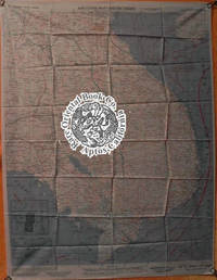
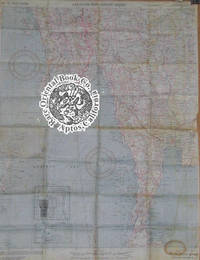
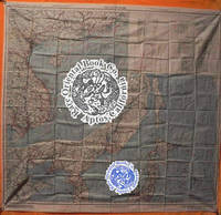
ARMY MAP SERVICE. USA. U. S.
A.A.F. CLOTH CHART. No. NJ 50 & No. NJ 51. No. NJ 50 Pei-P'ing Peking & No. NJ
Washington D.C. 1943-44 Army Map Service.Silk color maps 2 sides = 2 maps circa 63 x 63.5 c m. NJ 50: FIRST EDITION 1943; NJ 51: Second edition 1944 both AMS 2 type maps fine condition exceptionally clean & bright folded as issued. . . . . . MAP OF MANCHURIA NORTH EAST CHINA & KOREAN AREAS . . . ORIGINAL WORLD WAR 2 "E & E" "ESCAPE & EVASION" . . . SURVIVAL MAP . . . USED BY "U.S. ARMY AIR FORCES A.A.F. "FLYING TIGERS" . . . PILOTS & AIR CREW OF THE 14TH & 23 AIR FORCES . . . THROUGHOUT CHINA 1942-1945 . . . A.A.F.Army Air Force issue shows: NORTH EAST CHINA MANCHURIA & KOREA . Maps: NJ 50: PEKING AND SURROUNDING AREAS. TIENTSIN GULF OF CHILI MOUTH OF THE HUANG HO Yangtse RIVER LAI CHOU BAY & TSINAN. With two magnetic compasses. . NL 51: NORTH EAST CHINA MANCHURIA KOREA LIAONING PENINSULA JAPANESE KWANTUNG LEASED TERRITORY DAIREN RYOJUN PORT ARTHUR PECHILI STRAIT SHANTUNG THE NORTH-EAST CHINA COAST & THE WEST COAST OF KOREA. With four magnetic compasses. . This map shows a good portion of the areas held by the Japanese during the Sino-Japanese war beginning in 1937 through August 1945. . Both sides of the maps show from left 120 degrees to 126 degrees east; from 40 degrees north south to 36 degrees. . With legend key index to adjoining sheets inset "index to boundaries" in Manchuria Korea China and the Yellow sea. With glossary of Chinese & Korean words. Key to altitude tints chart from sea level to over 2500 meter in height by colors. Scale: 1:1000000 with miles kilometers & nautical miles. Legend to various features found on the map roads railroads provincial boundaries telegraph lines radio stations &c. . With an "Index to Boundaries:" on each map: . NJ 50: Hopeh Gulf of Chili Shantung Chahar Shansi & Honan. . NJ 51: Manchuria Korea China & Yellow Sea Huang Hai . CONDITION: The maps are in excellent unused condition there are no stains or other flaws. . This map was part of the U.S. Army Air Force & Naval flyers "E & E" Escape and Evasion survival kit printed on thick silk parachute cloth. . These maps were often worn as neck scarves by fighter pilots and other air crew members as scarves for warmth and to insure if they went down the map would be available to escape and evade the enemy. . Each air crew member carried among other survival supplies a .38 or .45 caliber pistol survival knife a signal mirror stainless steel or glass compass and basic food rations fishing kit water purification tablets minor medical supplies; the whole kit was tucked into the pant pocket of the flight suit. . The majority of these perishable maps have been lost during World War II. Few survived the attrition rate of war time and bad climate. This map was given to American fliers in the Pacific war against Japan. It was the "last hope" to insure downed fliers had a chance to navigate their way back to friendly forces. . NJ 50: Hopeh Gulf of Chili Shantung Chahar Shansi & Honan. . NJ 51: Manchuria Korea China & Yellow Sea Huang Hai . CONDITION: The maps are in excellent unused condition there are no stains or other flaws. . SURVIVAL MAP: . This map was part of the U.S. Army Air Force A.A.F. & Naval flyers "E & E" Escape and Evasion survival kit printed on thick silk parachute cloth. . These maps were often worn as neck scarves by fighter pilots and other air crew members as scarves for warmth and to insure if they went down the map would be available as their "Last Hope" to evade and escape the Japanese enemy. . Each air crew member carried among other survival supplies a .38 or .45 caliber pistol survival knife a signal mirror stainless steel or glass compass and basic food rations fishing kit water purification tablets minor medical supplies; the whole kit was tucked into the pant pocket of the flight suit. . The majority of these perishable maps have been lost during World War 2. Few survived the attrition rate of war time and sultry Asian climates. This map was given to American fliers in the Pacific war against Japan. It was the "last hope" & chance for downed fliers to navigate their way back to friendly forces. . REFERENCES: . BALDWIN R.E. et al.:LAST HOPE THE BLOOD CHIT STORY. DOLL John G.: CLOTH MAPS CHARTS AND BLOOD CHITS OF WORLD WAR 2. http://www.escape-maps.com/escape_maps/history_of_wwii_us_cl oth_escape_maps.htm#3.___Asiatic_Series . . hardcover
Riferimento per il libraio : 32010501

|
|
|
ARMY MAP SERVICE. USA. U. S.
A.A.F. CLOTH MAP ASIATIC SERIES: No. 32 & No. 33. NO. 32 FRENCH INDO CHINA & NO.
Washington D.C. 1943-44 U. S. Army Map Service. Silk map folds circa 10.3 x 7 cm.opens circa 51 x 65 cm. very good clean excellent copy2 color maps2 sides glossarylegend magnetic compass & current flows. FIRST EDITION FIRST ISSUE . . . . ISSUED BY U.S. A.A.F. ARMY AIR FORCE . . "A.V.G." AMERICAN VOLUNTEER GROUP" & "FLYING TIGERS" . . & THE FOURTEENTH AIR FORCE IN CHINA & BURMA "CBI" . . . . AN ORIGINAL WORLD WAR2 SURVIVAL & EVASION MAP . . FOR "I.E." & "FLYING TIGER" PILOTS FIGHTING JAPAN . . A SUPERB MAP OF SOUTHERN CHINA FROM KUNMING TO GUANGZHOU . . KIANGSI GUANGXI NANNING LIUCHOW LIUZHOU KWEILIN . . GUILIN FROM CHUNGKING CHONGQING . . FRENCH INDO-CHINA HANOI . . FROM NORTH VIETNAM SOUTH & DOWN TO SAIGON . . INCLUDING THAILAND CAMBODIA & LAOS . This excellent and detailed cloth map was used by the "A.V.G." "AMERICAN VOLUNTEER GROUP" known as the "FLYING TIGERS" in the "I.E." "CHINA-BURMA-INDIA" theater throughout World War 2 in China Burma & Indo China. . This "E & E" "Escape & Evasion" cloth map was carried by pilots & air crew on combat missions and attacks on Japanese assets. This map was valuable to downed pilots and crew behind hostile and enemy lines. . It was first carried by the "A.V.G." fighter pilots in early 1942 when they first attacked the Japanese Air Force over Burma: air combat over Rangoon Touongoo and Southwest China Kunming Chiang Mai Thailand Hanoi and the strike against Japanese air planes parked at Noi Bai airfield. . The famous "Battle of Toungoo" Burma March 19-March 29 1942 was one of the key battles in the Battle of Yunnan-Burma Road in the Burma Campaign of World War II and Second Sino-Japanese War. The failure to hold the city of Toungoo opened up the route for the Japanese to make their lunge to Lashio around the allied flank and into the Chinese rear. The "A.V.G." fighter pilots performed brilliantly downing a substantial number of Japanese planes with minor losses to themselves. . This map and others like it for the adjacent areas were commonly worn on fighter pilot's neck or put in the pocket of the flight jacket survival vest or in the flight suit pant leg pocket. . MAP NO. 32: FRENCH INDO CHINA: Dated 1944. A.A.F. Army Air Force issue. A pair of maps one on each side in color. Shows most of old Vietnam from just above 19 degrees north down to just below 9 degrees South and from 101 degrees at the West to 110 degrees to the West about half of Hainan Island the whole coast line from North to South down to Nga Ba Hoc Nang including Poulo Condore Saigon Nha Trang Tourane part of Thailand the West Cambodia and Laos Vientiane. . MAP NO. 33: CENTRAL CHINA: Dated 1943. Shows: Ch'ung Ch'ching Chungqing down to Yunnan province and Kunming. Kuangsi Guangxi province: Kweilin Guilin Liuchow Liuzhou Nanning and points south to French Indo China. . Hanoi Kwangchow and the South China Sea with the North tip of Hainan Island the Gulf of Tonkin and the border between China & North Vietnam. . This area was all part of the basic combat region for the "A.V.G." & "FLYING TIGERS" later for the FOURTEENTH AIR FORCE. The Americans prosecuted the war against Japanese forces throughout this area. . With ocean currents noted for survival back to land. The map also has other important information for downed pilots such as an Annual Magnetic Change compass miles & kilometer scale nautical miles 1:1000 000 altitudes of land mass legend & key to symbols roads towns cities rivers mountains and an index to international boundaries. . This map was part of the U.S. Army Air Force & Naval flyers "E & E" Escape and Evasion survival kit printed on thick silk parachute or other indelible cloth. Each air crew member carried among other survival supplies a .38 caliber pistol survival knife a signal mirror stainless steel or glass compass and some survival food rations fishing kit water purification tablets along with minor medical supplies; the whole kit was tucked into flight suit pocket survival vest or flyers sheepskin jacket or pants pockets. . The majority of these perishable maps have been lost during WW2 and very few survived. This map was a fliers "Last Hope" to get back to friendly forces once they parachuted our of their plane or after an unexpected landing behind Japanese lines. . REFERENCE: . BALDWIN R.E. et al.: LAST HOPE THE BLOOD CHIT STORY. DOLL John G.: CLOTH MAPS CHARTS AND BLOOD CHITS OF WORLD WAR 2. http://en.wikipedia.org/wiki/Battle_of_Toungoo . . hardcover
Riferimento per il libraio : 38006901
|
|
|
ARMY MAP SERVICE. USA. U. S.
A.A.F. CLOTH MAP ASIATIC SERIES: No. C 43 & C 44. No. C 43 MINDANAO ISLAND And
Washington D.C. 1944 Army Map Service U.S. Army. Silk map folds down to be ca. 8.5 x 13.5 cm. opens up to ca. 95 x 52 cm. color printed flawless bright and superb copy as new condition directional magnetic compass 12 maps in all. . . . . ORIGINAL WORLD WAR 2 SURVIVAL & EVASION MAP . A.A.F.= Army Air Force. This silk cloth has two maps one per side. The first map shows Mindanao Basilan Island at the top the lower tip of Negros Siquijor as well as the Camigiun Islands & at the bottom or South end Jolo Island with an index inset showing a larger area map with this map located in the big picture. There is also an inset of a close-up of Mindanao Siargao and Panaon Islands. . The back side shows at the top the Southern part of Balbac Island and a good part of North Borneo down to Sibuko Bay the Tawitawi Group & the Jolo Island group to the extreme East. The Sulu Archipelago is at the lower right corner with an inset index to the larger area of the South China Sea. With an Annual Magnetic Change compass scale in miles kilometers nautical miles 1:1000000 legend or key to symbols roads towns cities rivers mountains and an index to the boundaries. . USED BY THE FLYING TIGERS: This map and many similar to it were part of the items issued to FLYING TIGER pilots and A.V.G. AMERICAN VOLUNTEER GROUP pilots. They were often tied around the neck to keep them warm while flying. . This map was part of the U.S. Army Air Force and Naval flyers "E & E" survival kit Escape & Evasion printed on silk parachute cloth. These maps were often worn by fighter and other air crew members as scarves to insure they would be with the downed airman if/when his plane or he had to parachute out into the sea or over land. . Each air crew member carried among other survival supplies a .38 caliber pistol survival knife a signal mirror stainless steel or glass compass & some basic food rations fishing kit water purification tablets along with minor medical supplies; the whole kit was tucked into the pant pocket of the flight suit. The mass majority of these maps have perished during World War II & few if any others survived the attrition rate of war time & climate prevented many from ever being brought back home. This map and others like it were issued to all fight crews in the Pacific war against Japan to insure that downed fliers had some chance to navigate their way back to friendly forces. . . hardcover
Riferimento per il libraio : 25041301
|
|
|
ARMY MAP SERVICE. USA. U. S.
A.A.F. CLOTH MAP ASIATIC SERIES: No. C 52 & No. C 53. No. C 52 JAPAN & SOUTH CHI
Washington D.C. 1945 Army Map Service U.S. Army. Silk map folds down to ca. 12.5 x 14.5 cm. opens up to 83.5 x 83.5 cm. color printed 2 sides bright superbly clean unused copy as issued two maps in all like "NEW'. O B S C U R E . . . . ORIGINAL WORLD WAR 2 SURVIVAL & EVASION MAP . .SHOWING A VERY LONG EAST COAST OF RUSSIA GULF OF SAKHALIN . . TARTARY STRAIGHT SOUTH DOWN THE COAST AMUR RIVER . . VLADIVOSTOK ALL OF MANCHURIA KOREA MUKDEN HSINKING . . DAIREN GULF OF CHILI BEIJING SHANGHAI WEIHAIWEI . . TSINGTAU NORTH HOKKAIDO & HONSHU KURIL ISLANDS AMOY . . SWATOW HONG KONG MACAO CANTON KWANGCHOW HAINAN . . YUNNAN KUNMING GUILIN LIUZHOU NANNING HANOI DOWN . . THE COAST TO VIETNAM LAOS CAMBODIA S. HONSHU KYUSHU . . TAIWAN PHILIPPINES HANGZHOU SUCHOW NANKING NINGBO . . FOOCHOW AMOY OKINAWA & TOO MANY OTHERS TO LIST . . SHOWING GREAT DETAILS: ROADS RAILROADS AND RIVERS . U.S.A.A.F. United States Army Air Force issue one on each side one sheet = 2 maps. in all printed in full color. . No. C-52: JAPAN AND SOUTH CHINA SEAS. Shows Yunnan Fu Kunming City in the uppermost left corner at about 24.5 degrees by 103 degrees; then Kweilin Guilin at 110 degrees and Amoy Xiamen Shanghai Nanking Nanjing Foochow and the edge of the Pescadores on the Tropic of Cancer at the north end of the map. . Includes the large operational area of the "FLYING TIGERS" "A.V.G." & the FOURTEENTH AIR FORCE in China. Including important airbase cities: Nanning Liuzhou Kweilin & Kunming. . Below these areas from the left or extreme west Laos Cambodia Phnom Penh Saigon Hanoi all of Indo-China Vietnam down to Paulau Condor sic Paolo Condor Island and the tip of Vietnam at 8 degrees. Hainan Island Macao Hong Kong up the coast to Shantou. . No. C-53: EAST CHINA SEAS: Shows Yenchowfu and Changtse upper left Part of Korea at 35 degrees Japan from Sendai down to Okinawa all of Formosa to the Philippines Baguio Manila all of that area down to Albay. Including Shanghai Nanjing Qingdao Hangzhou most of the east coast of China Taiwan & Korea. . The large inset to the right shows Sakhalin the Kuril Islands Hokkaido Northern tip of Honshu Aomori down to Kanazawa Choshi at about 36 degrees. The Amur River and much of extreme eastern Russia Vladivostok down the Pacific coast Manchuria Mukden Korea Port Arthur Dairen Gulf of Chili Beijing Paotingfu down to Suzhou at 34 degrees. Up the coast of the Yellow Sea Qingdao and that area. . The back side shows the balance of the map are from the front side. From the left Tsinan Yenchowfu Weihaiwei down the Yellow Sea along the Pacific coast to Nanjing Shanghai Hangzhou Ningbo Taichofu Wenchow Funing fu Lienkong Fuzhou Xiamen down to Yunsiaoh across the Formosa Straits to all of Taiwan Formosa South to the Philippines Batan the main island of Luzon Manila down to almost 13 degrees south ending at Sorsogon Gubat. The rest of the right east portion shows the Marianas Islands Guam at the extreme lower right the Ogasawara Kanzan groups with Korea at the upper middle from about 37 degrees showing all from Shunsen Keijo Seoul down to Kanra San the southern island. Showing much of Japan from where the other map left off: Sakata on Honshu all of Japan Shikoku Kyushu Tokara Group the island chains Amami Okinawa groups Naha Ryukyu Islands/Okinawa down to Taiwan. . INSET MAPS: No. C-52: has one very large inset of N. Russia & N. Sakhalin south down to Korea Tsingtau and Chowfu. And Hokkaido Honshu down to Urawa 36 degrees south. . A second inset shows the key & legend to lines on the map currents winds scale 1/4000000 or 1/4m. heights in meters with 'Location Index" which is a key and guide to other adjacent maps in this series and this geographical area. . All part of the basic combat operation region for the U.S. A.A.F. U.S. Navy war against Japan. With ocean currents noted for possible air crew survival back to land. . USED BY THE "FLYING TIGERS:" This map and many similar to it were part of the "E & E" survival items issued to "FLYING TIGER" and "A.V.G." "AMERICAN VOLUNTEER GROUP" pilots. They were often tied around the neck by pilots and air crew while flying combat missions. . The map also has an Annual Magnetic Change compass miles scale kilometers nautical miles 1:1000 000 altitudes of land mass legend or key to symbols roads towns cities rivers mountains and an index to boundaries. . This map was part of the U.S. Army Air Force & Naval flyers "E & E" Escape and Evasion survival kit printed on thick silk parachute cloth. These maps were often worn by fighter and other air crew members as scarves to insure they would be with the downed airman if/when his plane or he had to parachute out into the sea or over land. Each air crew member carried among other survival supplies a .38 caliber pistol survival knife a signal mirror stainless steel or glass compass and some basic food rations fishing kit water purification tablets along with minor medical supplies; the whole kit was tucked into the pant pocket of the flight suit. . The majority of these perishable maps have been lost during World War II and very few survived the attrition of war time and humid climates. This map was considered the "LAST HOPE" for safe return to Allied lines. Given to fliers in the Pacific war against Japan. . . hardcover
Riferimento per il libraio : 38000902
|
|
|
ARMY MAP SERVICE. USA. U. S.
A.A.F. CLOTH MAP ASIATIC SERIES: No. 34 & No. 35. No. 34 SOUTHEAST CHINA & No.
Washington D.C. 1945 Army Map ServiceU.S. Army.Silk cloth folds down 8.5 x 13.5 cm. opens to 66 x 53 cm. very good example feint stain color printed two sides 2 maps in all obscure. . . . . . . ORIGINAL WORLD WAR 2 "E & E" "ESCAPE & EVASION" . . . SURVIVAL CLOTH MAP USED BY :"FLYING TIGERS" & "A.V.G." . . . "AMERICAN VOLUNTEER GROUP" THROUGHOUT CHINA: . . . NANJING SHANGHAI HONG KONG MACAO CANTON XIAMEN . . FORMOSA TAIWAN FOOCHOW HANGCHOW HANKOW CHAOCHOU . . SWATOW NANKING NANJING KAI-FENG . . AND OTHER POINTS NORTH & SOUTH . A.A.F.= Army Air Force issue this pair of maps shows all the major parts of China from a bit above 38 degrees at the North and 109 degrees from the West to 123 degrees at the East and South down to just below 22 degrees including the South China sea the last island is one more degree South below Canton Hong Kong and Macao with a nice inset of all of Taiwan. This was the basic combat region for the Pacific war against Japan. . USED BY THE "A.V.G." & FLYING TIGERS THROUGHOUT CHINA: . This map and many similar to it were part of the items issued to FLYING TIGER pilots and A.V.G. AMERICAN VOLUNTEER GROUP pilots. They were often tied around the neck to keep them warm while flying. . A CLOTH MAP COLOR PRINTED ON TWO SIDES: . Number 34 SOUTHEAST CHINA: Sshows from Nan-Ching Nanking or Nanjing this city is also shown on both sides of this maps to North down to Tao-chuang-fou St. John Island with Macau Hong Kong Canton. To the right is an inset map showing all of Formosa Taiwan. The whole Eastern coast of China from Tao-chuang-fou up to just above Shanghai. . Number 35 NORTHEAST CHINA: From Miao Lieh-tao island Lai-chou Wan at the far East and Li-ch-eng city to the Great Wall at extreme West at the Yellow River. Down South to Hankow Hang-chow area. K'ai-feng is about in the center of this map. With an inset of and index to the other maps in this area and series sea currents key guide to symbols. . A detailed map showing a substantial number of small towns big cities lakes rivers train routes roads major highways &c. With seasonal ocean currents noted for possible survival back to land. The map also has an index inset to related other area silk maps. Miles scale kilometers nautical miles legend or key to symbols roads towns cities rivers & mountains. This map was part of the U. S. Army Air Force & Naval flyers "E & E" survival kit "Escape and Evasion" printed on thick silk parachute cloth. . These maps were often worn by fighter pilots and other air crew members as scarves to insure they would be with the downed airman if/when his plane or he had to parachute out into the sea or over land. Each air crew member carried among other survival supplies a .38 or .45 caliber pistol survival knife a signal mirror stainless steel or glass compass and some basic food rations fishing kit water purification tablets along with minor medical supplies; the whole kit was tucked into the pant pocket of the flight suit. . The majority of these perishable maps have been lost during World War 2 and few if any others survived the attrition rate of war time and climate prevented many from ever being brought back home. This map was given to fliers in the Pacific war against Japan to insure downed fliers had some chance to navigate their way back to friendly forces. These maps are truly RARE and seldom found on the market. . . hardcover
Riferimento per il libraio : 25041205

|
|
|
ARMY MAP SERVICE. USA. U. S.
A.A.F. CLOTH CHART. No. NL 50 & No. NL 51. EASTERN ASIA. NL 50 BUIR NOR & NL. 51
Washington D.C. 1943-1944 Army Map Service.Silk maps color printed two sides exceptionally clean bright copy opens to 55 x 63 cm. folds to 14.5 x 17 cm. NL 50: 1944; NL 51: 1943 type AMS 2 both maps are the OBSCURE FIRST EDITIONS. . . . . MAP OF EASTERN ASIA . . . ORIGINAL WORLD WAR 2 "E & E" "ESCAPE & EVASION" . . . SURVIVAL MAP . . . USED BY "U.S. ARMY AIR FORCES A.A.F. "FLYING TIGERS" . . . PILOTS & AIR CREW OF THE 14TH & 23 AIR FORCES . . . THROUGHOUT CHINA 1942-1945 . This is one of the more obscure maps on An obscure map of North China Mongolia Manchuria the Great Wall & Heilongjiang formerly Lung-Chiang . This silk cloth map is color printed on both sides. . No.NL 50: BUIR NOR: shows from 48 degrees North to 44 South; 114 West to 120. From the North or top it shows Manchuria Buir Nor lake North Hsingan South down to Inner Mongolia Chahar West Hsingan. Three magnetic compasses. FIRST EDITION 1944 AMS 2. . No. NL 51 TSITSIHAR Lung-Chiang as in Heilongjiang: from 48 degrees North to 44 South; 120 West to 126 East. Shows the Great Wall from the great city of Lung-Chiang Black Dragon River down to Nung-an and much of the Sungari River. With three magnetic compasses. FIRST EDITION 1943 AMS 2. . INDEX OF COVERAGE: . NL 50: Manchuria Outer Mongolia Khalkha Mongols Silingol League Inner Mongolia Chahar Jo-odo League & West Hsingan. . NL 51: Hsing-an-tung Sheng Hsing-an-nan Sheng Pei-an Sheng Lung-Chiang Sheng Pin-Chiang Sheng Manchuria Hsing-an-Hsi Sheng Chi-lin Sheng & China. . With legend keys to map symbols. . INDEX TO ADJOINING SHEETS glossary scale: 1:1000000 with distance scale in miles kilometers and nautical miles altitude tints: key to heights by colors. . This map shows a good portion of the areas held by the Japanese during the Sino-Japanese war 1937-August 1945. . CONDITION: The maps are in excellent unused condition there are no stains or other flaws. Like "NEW" in collector's fine condition. . SURVIVAL MAP: . This map was part of the U.S. Army Air Force A.A.F. & Naval flyers "E & E" Escape and Evasion survival kit printed on thick silk parachute cloth. . These maps were often worn as neck scarves by fighter pilots and other air crew members as scarves for warmth and to insure if they went down the map would be available as their "Last Hope" to evade and escape the Japanese enemy. . Each air crew member carried among other survival supplies a .38 or .45 caliber pistol survival knife a signal mirror stainless steel or glass compass and basic food rations fishing kit water purification tablets minor medical supplies; the whole kit was tucked into the pant pocket of the flight suit. . The majority of these perishable maps have been lost during World War 2. Few survived the attrition rate of war time and sultry Asian climates. This map was given to American fliers in the Pacific war against Japan. It was the "last hope" & chance for downed fliers to navigate their way back to friendly forces. . REFERENCES: . BALDWIN R.E. et al.:LAST HOPE THE BLOOD CHIT STORY. DOLL John G.: CLOTH MAPS CHARTS AND BLOOD CHITS OF WORLD WAR 2. http://www.escape-maps.com/escape_maps/history_of_wwii_us_cl oth_escape_maps.htm#3.___Asiatic_Series . . hardcover
Riferimento per il libraio : 27066501
|
|
|
ARMY MAP SERVICE. USA. U. S.
A.A.F. CLOTH MAP ASIATIC SERIES: No. 34 & No. 35. No. 34 SOUTHEAST CHINA & No.
Washington D.C. 1944 Army Map Service U.S. Army. Silk map folds down: 8.5 x 13.5 cm. opens up to 64.5 x 52 cm.clean flawless bright & excellent copy color 2 maps folded as issued. . . . . . . ORIGINAL WORLD WAR 2 "E & E" "ESCAPE & EVASION" . . . SURVIVAL CLOTH MAP USED BY :"FLYING TIGERS" & "A.V.G." . . . "AMERICAN VOLUNTEER GROUP" THROUGHOUT CHINA: . . . NANJING SHANGHAI HONG KONG MACAO CANTON XIAMEN . . FORMOSA TAIWAN FOOCHOW HANGCHOW HANKOW CHAOCHOU . . SWATOW NANKING NANJING KAI-FENG . . AND OTHER POINTS NORTH & SOUTH . A.A.F.= Army Air Force issue this pair of maps shows all the major parts of China from a bit above 38 degrees at the North and 109 degrees from the West to 123 degrees at the East and South down to just below 22 degrees including the South China sea the last island is one more degree South below Canton Hong Kong and Macao with a nice inset of all of Taiwan. This was the basic combat region for the Pacific war against Japan. . USED BY THE "A.V.G." & FLYING TIGERS THROUGHOUT CHINA: . This map and many similar to it were part of the items issued to FLYING TIGER pilots and A.V.G. AMERICAN VOLUNTEER GROUP pilots. They were often tied around the neck to keep them warm while flying. . A CLOTH MAP COLOR PRINTED ON TWO SIDES: . Number 34 SOUTHEAST CHINA: Sshows from Nan-Ching Nanking or Nanjing this city is also shown on both sides of this maps to North down to Tao-chuang-fou St. John Island with Macau Hong Kong Canton. To the right is an inset map showing all of Formosa Taiwan. The whole Eastern coast of China from Tao-chuang-fou up to just above Shanghai. . Number 35 NORTHEAST CHINA: From Miao Lieh-tao island Lai-chou Wan at the far East and Li-ch-eng city to the Great Wall at extreme West at the Yellow River. Down South to Hankow Hang-chow area. K'ai-feng is about in the center of this map. With an inset of and index to the other maps in this area and series sea currents key guide to symbols. . A detailed map showing a substantial number of small towns big cities lakes rivers train routes roads major highways &c. With seasonal ocean currents noted for possible survival back to land. The map also has an index inset to related other area silk maps. Miles scale kilometers nautical miles legend or key to symbols roads towns cities rivers & mountains. This map was part of the U. S. Army Air Force & Naval flyers "E & E" survival kit "Escape and Evasion" printed on thick silk parachute cloth. . These maps were often worn by fighter pilots and other air crew members as scarves to insure they would be with the downed airman if/when his plane or he had to parachute out into the sea or over land. Each air crew member carried among other survival supplies a .38 or .45 caliber pistol survival knife a signal mirror stainless steel or glass compass and some basic food rations fishing kit water purification tablets along with minor medical supplies; the whole kit was tucked into the pant pocket of the flight suit. . The majority of these perishable maps have been lost during World War 2 and few if any others survived the attrition rate of war time and climate prevented many from ever being brought back home. This map was given to fliers in the Pacific war against Japan to insure downed fliers had some chance to navigate their way back to friendly forces. These maps are truly RARE and seldom found on the market. . . hardcover
Riferimento per il libraio : 25041204

|
|
|
Army Map Service
AAF Cloth Map -- Asiatic Series / No. 34 Southeast China; No. 35 Northeast China
Washington DC: Army Map Service. Very Good with no dust jacket. 1944. Map. This is a survival map issued to airman on missions which might result in going down in or near China. It contains information on wind and currents along with the usual feature of a physical map. It is printed on 26.5" x 20" silk-like fabric two maps back to back and folded to a 3"x5" size. The maps were compiled in 1943 and are dated 1944. This map shows no signs of use and is in very good condition. . Army Map Service unknown
Riferimento per il libraio : 870171
|
|
|
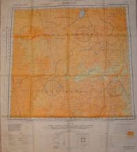
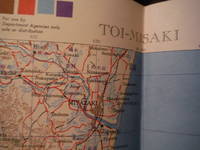
Army Map Service
Army Map Service Contour Map of Toi-Misaki Japan 1944
Washington DC: Army Map Service 1944-01-01. Map. Fine. Original WW II era folded color contour Map of Toi-Misaki Japan by the U. S. Army Map Service in 1944 Second Edition. Single sided. Edges smooth no chips or tears. Clean and unmarked. Folded into four sections. Map dimensions 22.25" H x 20" W including borders. Scale 1:250000 Contour intervals - 100 meters. Polyconic Projection. Highly detailed. Fine condition. Numerous WW II era maps of Japan listed and available. Additional photos available upon request. All items carefully packed to avoid damage from moisture and rough handling. Army Map Service unknown
Riferimento per il libraio : 027554
|
|
|
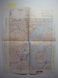
Army Map Service
Army Map Service Contour Map of Kumamoto Japan 1945
Washington DC: Army Map Service 1945-01-01. Map. Fine. Original WW II era folded color contour Map of Kumamoto Japan by the U. S. Army Map Service in 1945 Second Edition. Single sided. Edges smooth no chips or tears. Clean and unmarked. Folded into four sections. Map dimensions 22.25" H x 20" W including borders. Scale 1:250000 Contour intervals - 100 meters. Polyconic Projection. Highly detailed. Fine condition. Numerous WW II era maps of Japan listed and available. Additional photos available upon request. All items carefully packed to avoid damage from moisture and rough handling. Army Map Service unknown
Riferimento per il libraio : 027555
|
|
|
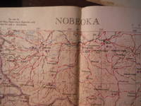
Army Map Service
Army Map Service Contour Map of Nobioka Central Japan 1944
Washington DC: Army Map Service 1944. Map. Fine. Original WW II folded color contour Map of Nobioka Central Japan by the U. S. Army Map Service in 1944. Single sided. Edges smooth no chips or tears; Clean and unmarked. Folded into four sections. Map dimensions 22" H x 18.5" W including borders. Scale 1:250000 Contour intervals - 100 meters. Polyconic Projection. Second Edition - 1944. Highly detailed. Fine condition. Numerous WW II era maps of Japan listed and available. Additional photos available upon request. All items carefully packed to avoid damage from moisture and rough handling. Army Map Service unknown
Riferimento per il libraio : 027094
|
|
|
Army Map Service
Army Map Service Contour Map of Sasebo Central Japan 1944
Washington DC: Army Map Service 1944. Map. Very Good. Original WW II era folded contour Map of Sosabo Central Japan by the U. S. Army Map Service in 1944. Single sided. Edges smooth no chips or tears; some crinkling along lower right edge. Clean and unmarked; toning along outer edge. Folded into four sections. Map dimensions 22.25" H x 20" W including borders. Scale 1:250000 Contour intervals - 100 meters. Polyconic Projection. Emergency Reproduction 1944 Highly detailed. VG condition. Numerous WW II era maps of Japan listed and available. Additional photos available upon request. All items carefully packed to avoid damage from moisture and rough handling. Army Map Service unknown
Riferimento per il libraio : 027092

|
|
|
Army Map Service
AUSTRALASIA. Planning Maps. A.M.S. 102 First Edition-AMS 2
Washington: Chief of Engineers U. S. Army 1943. July 1043. Scale 1:6336000. Very large folding color map. Printed at top: . "For use by War and Navy Department Agencies only Not for sale or distribution". Slight soiling on two exposed folds. First Edition. Very Good. Chief of Engineers, U. S. Army unknown
Riferimento per il libraio : 017086
|
|
|
Army Map Service
Chioggia. Sheet 65-I.
Washington 1944 cm. 50 x 45 scala 1 : 50.000 a colori. unknown
Riferimento per il libraio : 0-28823

|
|
|
Army Map Service
Djibouti series 2201 sheet 21
Army Map Service 1968. Folded map. V.g. Covers northern Somalia eastern Ethiopia and Socotra. Scale 1:2m. Army Map Service unknown
Riferimento per il libraio : 21894
|
|
|
Army Map Service Corps of Engineers
Europe Road Map Series 1:1000000 A.M.S. 6303 First Edition - AMS1 FRANCE
Washington DC: Army Map Service Corps of Engineers. Tan stiff paper covers. Previous owner's name at the top. Lightly bumped at the bottom. 14" by 7". Very large color fold-out map inside. The map is in excellent shape with no tears or repairs. . Very Good. Soft cover. 1944. Army Map Service Corps of Engineers paperback
Riferimento per il libraio : 042425
|
|
 Ricevere i risultati per e-mail
 Scaricare i risultati in PDF
 RSS feed


