|
|
|
Mengin Robert
NO LAURELS FOR DE GAULLE: AN APPRAISAL OF THE LONDON YEARS
New York: Farrar Straus & Giroux. Good with no dust jacket; Collectible - Ex-Library with Markings. 1966. Hardbound. 402 pages . Farrar, Straus & Giroux hardcover
Référence libraire : 45045
|
|
|
MENIGHETTI ROMOLO & NICASTRO FRANCO
History Of Autonomous Sicily
Legas Mineola: 2001. Softcover. Brand New Book. This is the most comprehensive history of Sicily from the signing of the Special Autonomy Statutes for the Island in 1947 to the present. Translated into English by Gaetano Cipolla. ISBN: 1881901289. Legas, Mineola: 2001 paperback
Référence libraire : 18743X2 ISBN : 1881901289 9781881901280

|
|
|
Mennais
A Travers La Correspondance de L'Abbe G. M. de la Mennais
Vannes France: Librairie Lafolye Freres et J. De Lamarzelle 1938 Book. Very Good -. Soft cover. Deuxieme serie. Notes Mennais to be from La Societe de Saint-Meen La Congregation de Saint-Pierre et L'Apostasie de Feli. 377 pages many of which are uncut. Cover has light rubmarks minor wear. Librairie Lafolye Freres et J. De Lamarzelle paperback
Référence libraire : 085899
|
|
|
Mennen Inge
POWER AND STATUS Administration Appointment Policies and Social Hierarchies in the Roman Empire AD 193-284
Radboud Universiteit Nijmegen. Near Fine. 2010. Softcover. 9090250093 . Very light shelfwear else Fine. ; Deals with changing power and status relations between the highest ranking representatives of Roman imperial power at the central level in a period when the Empire came under tremendous pressure AD 193-284. Based on epigraphic literary and legal materials the author deals with issues such as the third-century development of emperorship the shift in power of the senatorial elite and the developing position of senior military officers and other high equestrians. By analyzing the various senior power-holders involved in Roman imperial administration by social rank this book presents new insights into the diachronic development of imperial administration appointment policies and socio-political hierarchies between the second and fourth centuries AD; Proefschrift Diss. ; 269 pages; Dissertation . Radboud Universiteit Nijmegen paperback
Référence libraire : 8805 ISBN : 9090250093 9789090250090
|
|
|
Mennen Inge
POWER AND STATUS Administration Appointment Policies and Social Hierarchies in the Roman Empire AD 193-284
Radboud Universiteit Nijmegen. Near Fine. 2010. Softcover. 9090250093 . Very light shelfwear else Fine. ; Deals with changing power and status relations between the highest ranking representatives of Roman imperial power at the central level in a period when the Empire came under tremendous pressure AD 193-284. Based on epigraphic literary and legal materials the author deals with issues such as the third-century development of emperorship the shift in power of the senatorial elite and the developing position of senior military officers and other high equestrians. By analyzing the various senior power-holders involved in Roman imperial administration by social rank this book presents new insights into the diachronic development of imperial administration appointment policies and socio-political hierarchies between the second and fourth centuries AD; Proefschrift Diss. ; 269 pages; Dissertation . Radboud Universiteit Nijmegen paperback
Référence libraire : 8902 ISBN : 9090250093 9789090250090
|
|
|
Mensch, Pantaleon Metagoras Christian (Pseudonym):
Orthosophisches Denkmal dem Napoleon Bonaparte nach Aussprüchen der Wissenschaft und der Gerechtigkeit und zum Heile der Menschheit gesetzt von Pantaleon Metagoras Christian Mensch, dem Orthosophen.
20 x 11,5 cm. XLI, 392 Seiten. Schlichter Halbleinenband der Zeit mit handschriftl. Rückenschild. *Der dem Verfassernamen handelt es sich offensichtlich um ein Pseudonym, dieses wurde jedoch weder in den gängigen Pseudonymenlexika noch in den Einträgen der Bibliotheken erfasst bzw. aufgelöst. - Der unbekannt gebliebene Verfasser nennt dieses Werk in der Vorrede ein "philosophisches Denkmal auf Napoleon". - Vorsätze erneuert untere weiße Ecke des Titelblatt mit altem Papier ergänzt. Insgesamt ordentlich erhalten. Bücher de
|
|
|
MENTELLE (E.); CHANLAIRE (P.G.)
Carte d'Espagne et de Portugal
Paris, chez les auteurs, An VII (1799). 99 x 130 cm, étui et chemise cartonnés de l'époque (chemise et étui défraîchis).
Référence libraire : 18611

|
|
|
MENTELLE (Edme)
Géographie comparée ; ou Analyse de la géographie ancienne et moderne des peuples de tous les pays et de tous les âges ; accompagnée de tableaux analytiques & d'un grand nombre de cartes, les unes comparatives de l'état ancien & de l'état actuel des peuples ; les autres plus détaillées, & représentant ces pays dans leur état ancien, ou dans leur état moderne (...). Espagne ancienne
Paris, chez l'auteur, Nyon aîné, Nyon le jeune, 1781 in-8, xvj-388 pp., avec 5 planches hors texte (dont 2 tableaux et 3 cartes aux contours rehaussés de couleurs), avec quelques déchirures, basane fauve marbrée, dos à nerfs cloisonné et fleuronné, pièce de titre cerise, tranches marbrées (reliure de l'époque). Coiffe supérieure rognée, coins abîmés.
Référence libraire : 214005
|
|
|
Mentelle, E
Géographie comparée; ou Analyse de la Géographie ancienne et moderne des peuples de tous les pays et de tous les ages. Italie ancienne.
Paris, 1779. VIII, 346 S. Br. d. Zt. Umschl. etwas läd. Gebräunt, teils braunfl. Unbeschnitten. Ohne die Tafeln!
Référence libraire : 178244
|
|
|
Mentze Ernst. Editor
Vor Konge. Denne Bog Er Udgivet I Anledning Af Kong Christian X 70 Aars Dag
Chr. Erichsens Forlag. No Date ca. 1940. First edition hardcover in one third leather binding over marlbed boards with leather tips. Unpaginated marbled endpapers raised bands on spine photographs index. A bit of scraping to spine some rubbing to edges of boards and spine minor soiling to edges. Near Very Good. Hardcover. Book. Chr. Erichsens Forlag. No Date (ca. 1940). hardcover
Référence libraire : 21217
|
|
|
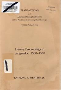
Mentzer Raymond A. Jr.
Heresy Proceedings in Languedoc 1500-1560 Transactions of the American Philosophical Society Volume 74 Part 5 1984
Philadelphia: The American Philosophical Society 1984. Retired library copy with all the usual stamps stickers and labels. Textblock is very rippled and edge-worn but is an excellent working copy and tight. Covers moderatly edge and corner worn with wrinkling and edge wear front and back; 183p. including index. Tan Printed Wraps. Good. Illus. by SOLD. 8vo - Over 7 3/4" -9 3/4 " Tall. Ex-Library Periodical. The American Philosophical Society Paperback
Référence libraire : EW2164 ISBN : 0871697459 9780871697455
|
|
|
Meny Y Wright V Eds
Centre-Periphery Relations in Western Europe
George Allen and Unwin 1985. This is an ex-library book and may have the usual library/used-book markings inside.This book has hardback covers. In fair condition suitable as a study copy. No dust jacket. George Allen and Unwin hardcover
Référence libraire : 5708611 ISBN : 0043521126 9780043521120

|
|
|
Meny Y et al Eds
Adjusting to Europe: The Impact of the European Union on National Institutions and Policies Routledge Research in European Public Policy
Routledge 1996. This is an ex-library book and may have the usual library/used-book markings inside.This book has soft covers. In fair condition suitable as a study copy. Please note the Image in this listing is a stock photo and may not match the covers of the actual item400grams ISBN:9780415144094 Routledge paperback
Référence libraire : 5708610 ISBN : 0415144094 9780415144094
|
|
|
Meny Y. and Knapp A.
Government and Politics in Western Europe: Britain France Italy Germany Comparative European Politics
Oxford University Press U.S.A. 1998. This is an ex-library book and may have the usual library/used-book markings inside.This book has soft covers. In fair condition suitable as a study copy. Please note the Image in this listing is a stock photo and may not match the covers of the actual item1050grams ISBN:9780198782216 Oxford University Press, U.S.A. paperback
Référence libraire : 8324076 ISBN : 0198782217 9780198782216

|
|
|
Meny Y. and Knapp A.
Government and Politics in Western Europe: Britain France Italy Germany Comparative European Politics
Oxford University Press U.S.A. 1998. This is an ex-library book and may have the usual library/used-book markings inside.This book has soft covers. In good all round condition. Please note the Image in this listing is a stock photo and may not match the covers of the actual item1050grams ISBN:9780198782216 Oxford University Press, U.S.A. paperback
Référence libraire : 8324079 ISBN : 0198782217 9780198782216
|
|
|
Meny Y. and Knapp A.
Government and Politics in Western Europe: Britain France Italy Germany Comparative European Politics
Oxford University Press U.S.A. 1998. This is an ex-library book and may have the usual library/used-book markings inside.This book has soft covers. In good all round condition. Please note the Image in this listing is a stock photo and may not match the covers of the actual item1050grams ISBN:9780198782216 Oxford University Press, U.S.A. paperback
Référence libraire : 8324077 ISBN : 0198782217 9780198782216
|
|
|
Meny Y. Wright V. Eds
Sensor Peripherary Relations in Western Europe
George Allen and Unwin 1985. This is an ex-library book and may have the usual library/used-book markings inside.This book has hardback covers. In fair condition suitable as a study copy. No dust jacket. George Allen and Unwin hardcover
Référence libraire : 5218448 ISBN : 0043521126 9780043521120
|
|
|
Menz, Gerhard
Der europäische Buchhandel seit dem Wiener Kongreß.
Würzburg, Konrad Triltsch Verlag, 1941. Gross-8° (23 x 15,5 cm). VII, 164 S. mit einigen Tabellen. Original-Broschur. Leicht schiefgelesen, wenige Bleistiftanstreichungen. Schnitt u. Umschlag gebräunt, angestaubt u. abgegriffen, teils etwas braunfleckig. (Das Buch im Kulturleben der Völker. Band 1)
Référence libraire : 19209AB

|
|
|
Menzel Wolfgang
The History of Germany from the Earliest Period to the Present Time by Wolfgang Menzel; translated from the fourth German edition by Mrs. George Horrocks vol. 1
London: Henry G. Bohn 1848. Hardcover. Very Good -. Vol. 1 only of 3: iv 556 p. engraved frontispiece portrait of Charlemagne; 18 cm. 19th-century half polished calf with marbled paper over boards. Six spine compartments between raised bands; gilt-tooled red and black labels in second and third compartments. All edges marbled matching the boards. Grey endpaper. This volume goes through Frederick II. In Very Good Condition: rubbed most heavily at corners; minor loss at head of back joint; clean and tight. <br/><br/> Henry G. Bohn hardcover
Référence libraire : 004515

|
|
|
Menzel, K[arl] A[ugust]
Geschichte der Jahre 1815 bis 1837. Aus Becker's Weltgeschichte, 7. Ausgabe, besonders abgedruckt.
Berlin, Humblot 1838. IV, 278 S., OHLdr., bestoßen u. berieben, Seiten etwas stockfleckig.
Référence libraire : HIST0676
|
|
|
Menzel, Wolfgang
Der Deutsche Krieg im Jahr 1866, in seinen Ursachen, seinem Verlauf und seinen nächsten Folgen dargestellt. 2 Bände.
Krabbe, Stuttgart 1867. XIV, 434 u. VIII, 503 S. Halbleder der Zeit mit marmorierten Einbanddeckeln. Gebrsp. Etwas beschabt u. bestoßen. Buchblock etwas gebräunt u. fleckig. Gutes Exemplar. Buchbindermarke W. Boeckh Offenburg.
Référence libraire : 17655

|
|
|
Menzel, Wolfgang
Geschichte der letzten vierzig Jahre (1816 - 1856). 2 Bände.
Stuttgart, Krabbe 1857. XIV, 478; VIII, 485 S Dekorative Leinenbände der Zeit mit Rückengoldpräg., Schnitt gebräunt, im Text fleckenfrei. Geschichte Europas vom Wiener Kongreß bis zum russischen Krieg.
Référence libraire : HIST0464a
|
|
|
Menzel, Wolfgang:
Europa im Jahr 1840.
20 x 12,5 cm. 192 Seiten. Orig.-Broschur., Rückenbezug mit kl. Fehlstelle am unteren Kapital. *Erste Ausgabe. Bücher de
|
|
|
Menzies Gavin
1434: The Year a Chinese Fleet Sailed to Italy and Ignited the Renaissance
London: Harpercollins Harper Collins Publisher. 2008. Very Good condition. Colour and black & white illustrations. 368 pages . Reprint. Trade Paperback. Harpercollins [Harper Collins Publisher] paperback
Référence libraire : BIB260694 ISBN : 0007275862 9780007275861

|
|
|
Meras Phyllis
The Mermaids of Chenonceaux and 828 Other Stories: An Anecdotal Guide to Europe
<p>New York: Congdon & Weed 1983 1st ed. 336pp. putty and brown cloth 8vo: near Very Good in a Very Good dj edges show age foxing; some browning of endpp; else a nice clean complete & tight copy</p> New York: Congdon & Weed hardcover
Référence libraire : 23982 ISBN : 0312925255 9780312925253

|
|
|
Meras Phyllis
The Mermaids of Chenonceaux: And 828 Other Stories: An Anecdotal Guide to Europe
New York New York USA and Ontario Canada: Congdon & Weed Inc and Beaverbooks Ltd 1983. Paperback. Very Good/No Jacket. Trade Paperback in Very Good Condition. A new approach to travel writing-delightful and interesting for the goers and the armchair travelers. A perfect companion to traditional travel guides and wonderful reading as well. Clean and unmarked blue wraps illustrated slight wear to extremities; no creasing; tight & solid. pages evenly toned clean no markings of any kind. xii 336 pages indexed. 5.5 x 8.25 inches. 1983 Congdon & Weed Inc and Beaverbooks Ltd New York New York USA and Ontario Canada Congdon & Weed, Inc and Beaverbooks, Ltd paperback
Référence libraire : 024070 ISBN : 0865531595 9780865531598

|
|
|
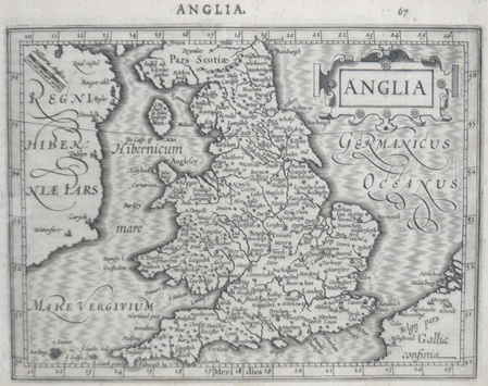
MERCATOR (Gerard) & HONDIUS (Jodocus).
[ANGLETERRE] Anglia.
[Dordrecht, Adrianus Bottius, 1610]. 145 x 183 mm.
Référence libraire : LBW06160
|
|
|
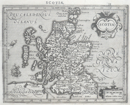
MERCATOR (Gerard) & HONDIUS (Jodocus).
[ECOSSE] Scotia.
[Dordrecht, Adrianus Bottius,]. 1610 150 x 185 mm.
Référence libraire : LBW0615f
|
|
|
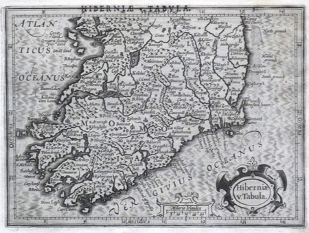
MERCATOR (Gerard) & HONDIUS (Jodocus).
[IRLANDE] Hiberniae v. tabula.
[Dordrecht, Adrianus Bottius, 1610]. 136 x 184 mm.
Référence libraire : LBW0615e
|
|
|
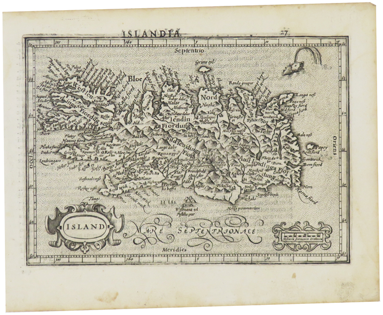
MERCATOR (Gerard) & HONDIUS (Jodocus).
[ISLANDE] Island.
[Dordrecht, Adrianus Bottius, 1610]. 134 x 186 mm.
Référence libraire : LBW0615c
|
|
|
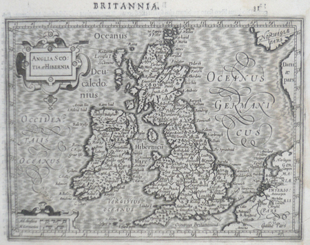
MERCATOR (Gerard) & HONDIUS (Jodocus).
[ROYAUME-UNI] Anglia Scotia et Hibernia.
[Dordrecht, Adrianus Bottius, 1610]. 142 x 178 mm.
Référence libraire : LBW0615d
|
|
|
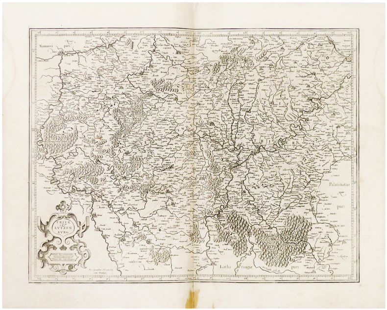
MERCATOR (Gerard).
[LUXEMBOURG] Trier & Lutzenburg.
[Amsterdam, 1603-1622]. 366 x 474 mm.
Référence libraire : LBW04179
|
|
|
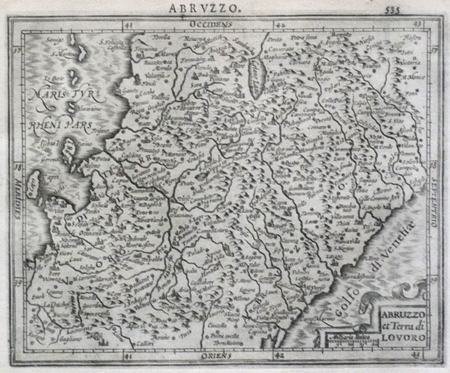
MERCATOR (Gerard);HONDIUS (Jodocus);
[ABRUZZES] Abruzzo et Terra di Lavoro.
Dordrecht Adrianus Bottius 1610 143 x 178 mm.
Référence libraire : LBW0618b
|
|
|
MERCATOR (Gerard);HONDIUS (Jodocus);
[BRESCIA/MILAN] Brescia episcopatus Mediolanu ducatus.
Dordrecht Adrianus Bottius 1610 147 x 180 mm.
Référence libraire : LBW06171

|
|
|
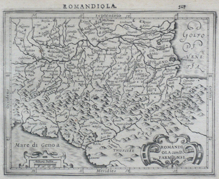
MERCATOR (Gerard);HONDIUS (Jodocus);
[EMILIE-ROMAGNE] Romandiola cum D. Parmensi.
Dordrecht Adrianus Bottius 1610 145 x 178 mm.
Référence libraire : LBW0616f
|
|
|
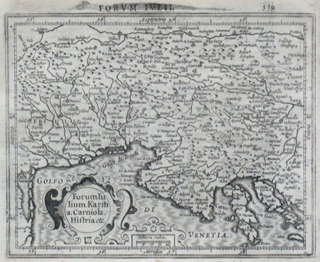
MERCATOR (Gerard);HONDIUS (Jodocus);
[ITALIE DU NORD] Forum Iulium Karstia Carniola Histria etc.
Dordrecht Adrianus Bottius 1610 143 x 178 mm.
Référence libraire : LBW06172
|
|
|
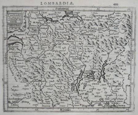
MERCATOR (Gerard);HONDIUS (Jodocus);
[LOMBARDIE] Lombardiae alpestris pars occidentalis cum Valesia.
Dordrecht Adrianus Bottius 1610 149 x 179 mm.
Référence libraire : LBW0616d
|
|
|
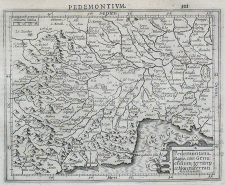
MERCATOR (Gerard);HONDIUS (Jodocus);
[PIEMONT] Pedemontana regio, cum Genuensium territorio et Montifferrati marchionatu.
Dordrecht Adrianus Bottius 1610 147 x 178 mm.
Référence libraire : LBW0616e
|
|
|
MERCATOR (Gerard);HONDIUS (Jodocus);
[POUILLES/CALABRE] Puglia Piana terra di Barri Otrato etc.
Dordrecht Adrianus Bottius 1610 134 x 177 mm.
Référence libraire : LBW0618c

|
|
|
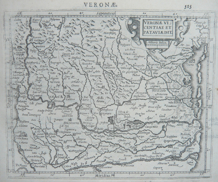
MERCATOR (Gerard);HONDIUS (Jodocus);
[VERONE] Veronae Vicentiae et Pataviae dit.
Dordrecht Adrianus Bottius 1610 150 x 178 mm.
Référence libraire : LBW06170
|
|
|
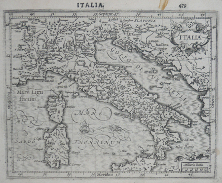
MERCATOR (Gerard);HONDIUS (Jodocus);
Italia.
Dordrecht Adrianus Bottius 1610 150 x 182 mm.
Référence libraire : LBW0616c
|
|
|
MERCATOR (Kremer) Gerard (1512 - 1594)
Cornubia, Devonia, Somersetus, Dorcestria, Wiltonia …
La carta del Sud-Ovest dell'Inghilterra e del Galles; include i territori di Cornovaglia, Devon, Sommerset, Dorset, Wilton, Glouchester, Glamorgan, Caermarden, Penbroke, Cardigan, Radnor Breknoke, Hereford e Wigorn. La carta viene preparata da Gerard Mercator per l’Atlantis Pars Altera (1595) pubblicato postumo alla morte dell’autore, sotto la supervisione del figlio Rumold Mercator, dallo stampatore di Duisburg Albert Buys. Composto da sei parti – pubblicate separatamente tra il 1589 e il 1594 – comprende 107 mappe, tutte tranne la carta del mondo di Rumold, firmate da Gerard Mercator. Le lastre vennero poi acquistate da Jodocus Hondius, che tra il 1606 e il 1630 le utilizzò per il suo Atlas Sive Cosmographicae Meditationes de Fabrica Mundi, integrandole ed aggiornandole con proprie “nuove” carte. Delle mappe di Mercator sono note anche ristampe curate da Johannes Janssonius. Le edizioni Hondius e Janssonius ebbero un grande successo commerciale e furono stampate in più lingue, con il testo al verso della carta in latino, francese, tedesco e olandese. La carta è incisa con i connotati tipici dell'opera mercatoriana. Le montagne sono allineate in un concetto di area montuosa, non per indicare vere catene o valli, ed hanno una struttura con qualche differenza nella dimensione, ma simile per quanto riguarda la forma, con pendici verticali e cime piatte. Le città sono mostrate attraverso castelli più o meno grandi caratterizzati da tetti slanciati ed aguzzi, simili a cappelli di mago. Esemplare tratto da Atlas Sive Cosmographicae Meditationes de Fabrica Mundi di Jodocus Hondius. Incisione in rame, in buono stato di conservazione. Bibliografia cfr. Koeman II Me 11 e Koeman II Me 13A, 1595); Van der Krogt 1:002; J. Keuning, The History of an Atlas, in “Imago Mundi” IV (1947) pp. 37-43; World Encompassed p. 134. A reissue of Mercator's regional map of South-West England by Hondius, in which the original cartouche has been replaced and Mercator's name erased. Includes the countries of Cornwall, Devon, Sommerset, Dorset, Wilton, Glouchester, Glamorgan, Caermarden, Penbroke, Cardigan, Radnor Breknoke, Hereford and Wigorn. The map is prepared by Gerard Mercator for his Atlantis Pars Altera (1595) published posthumously after the death of Mercator, by the Duisburg printer Albert Buys, under the supervision of his son Rumold Mercator. Composed of six parts - published separately between 1589 and 1594 - it includes 107 maps, all except Rumold's map of the world, made by Gerard Mercator. The plates were then purchased by Jodocus Hondius, who between 1606 and 1630 used them for his Atlas Sive Cosmographicae Meditationes de Fabrica Mundi, integrating and updating them with his own "new" maps. Of Mercator's maps are also known reprints edited by Johannes Janssonius. The Hondius and Janssonius editions had a great commercial success and were printed in several languages, with the text on the back of the map in Latin, French, German and Dutch. The map is engraved with the typical connotations of Mercatorian work. The mountains are aligned in a mountainous area concept, not to indicate true chains or valleys, and have a structure with some differences in size, but similar in shape, with vertical slopes and flat tops. The cities are shown through more or less large castles characterized by slender and pointed roofs, similar to wizard hats. Example from Atlas Sive Cosmographicae Meditationes de Fabrica Mundi by Jodocus Hondius. Copper engraving, in good condition. Bibliografia cfr. Koeman II Me 11 e Koeman II Me 13A, 1595); Van der Krogt 1:002; J. Keuning, The History of an Atlas, in “Imago Mundi” IV (1947) pp. 37-43; World Encompassed p. 134.

|
|
|
MERCATOR (Kremer) Gerard (1512 - 1594)
EUR: VIII TAB: (Europae Tabula Octava)
Carta tolemaica dell'antica regione della Sarmazia corrispondente all'attuale territorio di Ucraina e Russia. Mappa tratta dal Cl. Ptolemaei Alexandrini, Geographiae Libri Octo, pubblicata prima a Colonia da Gottfried von Kempen (1578) e poi ristampata dallo stesso editore nel 1584 (Van der Krogt 1, 502) e poi da Isaac Elsevier per il Theatrum Geographiae veteris di Petrus Bertius (Leyden 1618). Di tutte le edizioni di Tolomeo, quella di Gerard Kremer (Mercatore), pubblicata nel 1578, e forse tecnicamente la più bella. A questo punto la Geografia di Tolomeo perdeva però ogni pretesa di “attualità”, laddove lo scopo di Mercatore era quello di produrre un atlante del mondo classico che servisse da complemento al suo atlante moderno (per tale ragione egli aveva tentato di recuperare la forma originale dell’atlante tolemaico, scartandone le moderne accrezioni). L'interpretazione di Mercatore del testo tolemaico, per le 28 carte che illustrano la sua Geographia è stata, quindi, una delle più veritiere. Egli aveva passato 13 anni a ricercare, disegnare e incidere le carte, rinunciando anche alla pubblicazione delle sue carte “moderne”. Questo esemplare proviene dal Theatrum Geographia Veteris di Petrus Bertius edita a Leida nel 1618, che combina il Tolomeo di Mercator, le 8 tavole del Moretus per rappresentare la Tabula Peutingeriana e 14 mappe storiche delle regioni d'Europa derivate dal Parergon di Ortelius. Acquaforte su rame, in buone condizioni. Ptolemaic map of ancient Sarmatia the region between the Baltic, Adriatic and Black Seas. Map taken from the Cl. Ptolemaei Alexandrini, Geographiae Libri Octo, first published in Cologne by Gottfried von Kempen (1578) and then reprinted by the same publisher in 1584 (Van der Krogt 1, 502) and then by Isaac Elsevier for the Petrus Bertius’ Theatrum Geographiae veteris (Leyden 1618). Mercator's interpretation of the 28 Ptolemaic text was possibly one of the truest undertaken up until that time. He had spent 13 years researching, drawing and engraving the maps at much commercial sacrifice to himself, having seen Ortelius's Theatrum and De Jodes Speculum published, to become both technical and commercial successes. In later life he devoted himself to his edition of the maps in Ptolemy's Geographia, reproduced in his own engraving as nearly as possible in their original form. This example comes from the Theatrum Geographia Veteris of Petrus Bertius published in Leiden in 1618, which combines Mercator's Ptolemy, the 8 plates of Moretus to represent the Tabula Peutingeriana and 14 historical maps of the regions of Europe derived from the Parergon of Ortelius. Copperplate, in good condition.

|
|
|
MERCATOR (Kremer) Gerard (1512 - 1594)
Europa III Tab
Mappa tratta dal Cl. Ptolemaei Alexandrini, Geographiae Libri Octo, pubblicata prima a Colonia da Gottfried von Kempen (1578) e poi ristampata dallo stesso editore nel 1584 (Van der Krogt 1, 502) e poi da Isaac Elsevier per il Theatrum Geographiae veteris di Petrus Bertius (Leyden 1618). Di tutte le edizioni di Tolomeo, quella di Gerard Kremer (Mercatore), pubblicata nel 1578, e forse tecnicamente la più bella. A questo punto la Geografia di Tolomeo perdeva però ogni pretesa di “attualità”, laddove lo scopo di Mercatore era quello di produrre un atlante del mondo classico che servisse da complemento al suo atlante moderno (per tale ragione egli aveva tentato di recuperare la forma originale dell’atlante tolemaico, scartandone le moderne accrezioni). L'interpretazione di Mercatore del testo tolemaico, per le 28 carte che illustrano la sua Geographia è stata, quindi, una delle più veritiere. Egli aveva passato 13 anni a ricercare, disegnare e incidere le carte, rinunciando anche alla pubblicazione delle sue carte “moderne”. Questo esemplare proviene dal Theatrum Geographia Veteris di Petrus Bertius edita a Leida nel 1618, che combina il Tolomeo di Mercator, le 8 tavole del Moretus per rappresentare la Tabula Peutingeriana e 14 mappe storiche delle regioni d'Europa derivate dal Parergon di Ortelius. Acquaforte su rame, in buone condizioni. Map taken from the Cl. Ptolemaei Alexandrini, Geographiae Libri Octo, first published in Cologne by Gottfried von Kempen (1578) and then reprinted by the same publisher in 1584 (Van der Krogt 1, 502) and then by Isaac Elsevier for the Petrus Bertius’ Theatrum Geographiae veteris (Leyden 1618). Mercator's interpretation of the 28 Ptolemaic text was possibly one of the truest undertaken up until that time. He had spent 13 years researching, drawing and engraving the maps at much commercial sacrifice to himself, having seen Ortelius's Theatrum and De Jodes Speculum published, to become both technical and commercial successes. In later life he devoted himself to his edition of the maps in Ptolemy's Geographia, reproduced in his own engraving as nearly as possible in their original form. This example comes from the Theatrum Geographia Veteris of Petrus Bertius published in Leiden in 1618, which combines Mercator's Ptolemy, the 8 plates of Moretus to represent the Tabula Peutingeriana and 14 historical maps of the regions of Europe derived from the Parergon of Ortelius. Copperplate, in good condition.

|
|
|
MERCATOR (Kremer) Gerard (1512 - 1594)
Europa IIII Tab.
Mappa tratta dal Cl. Ptolemaei Alexandrini, Geographiae Libri Octo, pubblicata prima a Colonia da Gottfried von Kempen (1578) e poi ristampata dallo stesso editore nel 1584 (Van der Krogt 1, 502) e poi da Isaac Elsevier per il Theatrum Geographiae veteris di Petrus Bertius (Leyden 1618). Di tutte le edizioni di Tolomeo, quella di Gerard Kremer (Mercatore), pubblicata nel 1578, e forse tecnicamente la più bella. A questo punto la Geografia di Tolomeo perdeva pero ogni pretesa di “attualità”, laddove lo scopo di Mercatore era quello di produrre un atlante del mondo classico che servisse da complemento al suo atlante moderno (per tale ragione egli aveva tentato di recuperare la forma originale dell’atlante tolemaico, scartandone le moderne accrezioni). L'interpretazione di Mercatore del testo tolemaico, per le 28 carte che illustrano la sua Geographia è stata, quindi, una delle più veritiere. Egli aveva passato 13 anni a ricercare, disegnare e incidere le carte, rinunciando anche alla pubblicazione delle sue carte “moderne”. Acquaforte su rame, in buone condizioni. Map taken from the Cl. Ptolemaei Alexandrini, Geographiae Libri Octo, first published in Cologne by Gottfried von Kempen (1578) and then reprinted by the same publisher in 1584 (Van der Krogt 1, 502) and then by Isaac Elsevier for the Petrus Bertius’ Theatrum Geographiae veteris (Leyden 1618). Mercator's interpretation of the 28 Ptolemaic text was possibly one of the truest undertaken up until that time. He had spent 13 years researching, drawing and engraving the maps at much commercial sacrifice to himself, having seen Ortelius's Theatrum and De Jodes Speculum published, to become both technical and commercial successes. In later life he devoted himself to his edition of the maps in Ptolemy's Geographia, reproduced in his own engraving as nearly as possible in their original form. Copperplate, in good condition.

|
|
|
MERCATOR (Kremer) Gerard (1512 - 1594)
EUROPAE I TAB
Mappa tratta dal Cl. Ptolemaei Alexandrini, Geographiae Libri Octo, pubblicata prima a Colonia da Gottfried von Kempen (1578) e poi ristampata dallo stesso editore nel 1584 (Van der Krogt 1, 502) e poi da Isaac Elsevier per il Theatrum Geographiae veteris di Petrus Bertius (Leyden 1618). Di tutte le edizioni di Tolomeo, quella di Gerard Kremer (Mercatore), pubblicata nel 1578, e forse tecnicamente la più bella. A questo punto la Geografia di Tolomeo perdeva però ogni pretesa di “attualità”, laddove lo scopo di Mercatore era quello di produrre un atlante del mondo classico che servisse da complemento al suo atlante moderno (per tale ragione egli aveva tentato di recuperare la forma originale dell’atlante tolemaico, scartandone le moderne accrezioni). L'interpretazione di Mercatore del testo tolemaico, per le 28 carte che illustrano la sua Geographia è stata, quindi, una delle più veritiere. Egli aveva passato 13 anni a ricercare, disegnare e incidere le carte, rinunciando anche alla pubblicazione delle sue carte “moderne”. Questo esemplare proviene dal Theatrum Geographia Veteris di Petrus Bertius edita a Leida nel 1618, che combina il Tolomeo di Mercator, le 8 tavole del Moretus per rappresentare la Tabula Peutingeriana e 14 mappe storiche delle regioni d'Europa derivate dal Parergon di Ortelius. Acquaforte su rame, in buone condizioni. Ptolemaic map of British Isles. Showing landmarks, major cities and towns, rivers and parks. The map is decorated with a strapwork title cartouche, a sea monster and a fishing scene in the North Sea. Map taken from the Cl. Ptolemaei Alexandrini, Geographiae Libri Octo, first published in Cologne by Gottfried von Kempen (1578) and then reprinted by the same publisher in 1584 (Van der Krogt 1, 502) and then by Isaac Elsevier for the Petrus Bertius’ Theatrum Geographiae veteris (Leyden 1618). Mercator's interpretation of the 28 Ptolemaic text was possibly one of the truest undertaken up until that time. He had spent 13 years researching, drawing and engraving the maps at much commercial sacrifice to himself, having seen Ortelius's Theatrum and De Jodes Speculum published, to become both technical and commercial successes. In later life he devoted himself to his edition of the maps in Ptolemy's Geographia, reproduced in his own engraving as nearly as possible in their original form. This example comes from the Theatrum Geographia Veteris of Petrus Bertius published in Leiden in 1618, which combines Mercator's Ptolemy, the 8 plates of Moretus to represent the Tabula Peutingeriana and 14 historical maps of the regions of Europe derived from the Parergon of Ortelius. Copperplate, in good condition.

|
|
|
MERCATOR (Kremer) Gerard (1512 - 1594)
EUROPAE V TABULA
Carta tolemaica incentrata sulle antiche provincie romane della Rezia, Norico, Pannonia e Illiria, lungo la costa adriatica. Mappa tratta dal Cl. Ptolemaei Alexandrini, Geographiae Libri Octo, pubblicata prima a Colonia da Gottfried von Kempen (1578) e poi ristampata dallo stesso editore nel 1584 (Van der Krogt 1, 502) e poi da Isaac Elsevier per il Theatrum Geographiae veteris di Petrus Bertius (Leyden 1618). Di tutte le edizioni di Tolomeo, quella di Gerard Kremer (Mercatore), pubblicata nel 1578, e forse tecnicamente la più bella. A questo punto la Geografia di Tolomeo perdeva però ogni pretesa di “attualità”, laddove lo scopo di Mercatore era quello di produrre un atlante del mondo classico che servisse da complemento al suo atlante moderno (per tale ragione egli aveva tentato di recuperare la forma originale dell’atlante tolemaico, scartandone le moderne accrezioni). L'interpretazione di Mercatore del testo tolemaico, per le 28 carte che illustrano la sua Geographia è stata, quindi, una delle più veritiere. Egli aveva passato 13 anni a ricercare, disegnare e incidere le carte, rinunciando anche alla pubblicazione delle sue carte “moderne”. Questo esemplare proviene dal Theatrum Geographia Veteris di Petrus Bertius edita a Leida nel 1618, che combina il Tolomeo di Mercator, le 8 tavole del Moretus per rappresentare la Tabula Peutingeriana e 14 mappe storiche delle regioni d'Europa derivate dal Parergon di Ortelius. Acquaforte su rame, in buone condizioni. Ptolemaic map of the Roman Empire' provinces of Raetia, Noricum, Illyria, Noricum. Map taken from the Cl. Ptolemaei Alexandrini, Geographiae Libri Octo, first published in Cologne by Gottfried von Kempen (1578) and then reprinted by the same publisher in 1584 (Van der Krogt 1, 502) and then by Isaac Elsevier for the Petrus Bertius’ Theatrum Geographiae veteris (Leyden 1618). Mercator's interpretation of the 28 Ptolemaic text was possibly one of the truest undertaken up until that time. He had spent 13 years researching, drawing and engraving the maps at much commercial sacrifice to himself, having seen Ortelius's Theatrum and De Jodes Speculum published, to become both technical and commercial successes. In later life he devoted himself to his edition of the maps in Ptolemy's Geographia, reproduced in his own engraving as nearly as possible in their original form. This example comes from the Theatrum Geographia Veteris of Petrus Bertius published in Leiden in 1618, which combines Mercator's Ptolemy, the 8 plates of Moretus to represent the Tabula Peutingeriana and 14 historical maps of the regions of Europe derived from the Parergon of Ortelius. Copperplate, in good condition.

|
|
|
MERCATOR (Kremer) Gerard (1512 - 1594)
Forum Iulium, Karstia, Carniola, Histria et Windorum Marchia
Mappa regionale dettagliata delle regioni del Golfo di Venezia e del Golfo di Trieste, che comprende Friuli e Istria. Include la Slovenia, la Croazia nordoccidentale e parti dell'Italia e dell'Austria. La carta viene preparata da Gerard Mercator per il suo Italia, Sclavoniae et Graeciae tabula geographicae (Duisburg, 1589) che comprende un frontespizio allegorico e 22 carte geografiche della penisola, dei Balcani e della Grecia. Successivamente le carte sono ristampate nell’Atlantis Pars Altera (1595) pubblicato postumo alla morte del Mercatore, dallo stampatore di Duisburg Albert Buys, sotto la supervisione del figlio Rumold Mercator. Composto da sei parti – pubblicate separatamente tra il 1589 e il 1594 – comprende 107 mappe, tutte tranne la carta del mondo di Rumold, firmate da Gerard Mercator. Le lastre vennero poi acquistate da Jodocus Hondius, che tra il 1606 e il 1630 le utilizzò per il suo Atlas Sive Cosmographicae Meditationes de Fabrica Mundi, integrandole ed aggiornandole con proprie “nuove” carte. Delle mappe di Mercator sono note anche ristampe curate da Johannes Janssonius. Le edizioni Hondius e Janssonius ebbero un grande successo commerciale e furono stampate in più lingue, con il testo al verso della carta in latino, francese, tedesco e olandese. La carta è incisa con i connotati tipici dell'opera mercatoriana. Le montagne sono allineate in un concetto di area montuosa, non per indicare vere catene o valli, ed hanno una struttura con qualche differenza nella dimensione, ma simile per quanto riguarda la forma, con pendici verticali e cime piatte. Le città sono mostrate attraverso castelli più o meno grandi caratterizzati da tetti slanciati ed aguzzi, simili a cappelli di mago. Esemplare tratto da Atlas Sive Cosmographicae Meditationes de Fabrica Mundi di Jodocus Hondius. Acquaforte e bulino. Magnifica prova, impressa su carta vergata coeva, con margini, coloritura coeva, piccole ossidazioni, per il resto in perfetto stato di conservazione. Bibliografia cfr. Koeman II Me 11 e Koeman II Me 13A, 1595); Van der Krogt 1:002; J. Keuning, The History of an Atlas, in “Imago Mundi” IV (1947) pp. 37-43; World Encompassed p. 134. Detailed regional map of the Gufl of Venice and Gulf of Trieste regions, including Friuli and Istria. Includes Slovenia, northwestern Croatia and parts of Italy and Austria. The map is prepared by Gerard Mercator for his Italia, Sclavoniae et Graeciae tabula geographicae (Duisburg, 1589), which includes an allegorical frontispiece and 22 maps of Italy, the Balkans and Greece. Later, the maps are reprinted in the Atlantis Pars Altera (1595) published posthumously after the death of Mercator, by the Duisburg printer Albert Buys, under the supervision of his son Rumold Mercator. Composed of six parts - published separately between 1589 and 1594 - it includes 107 maps, all except Rumold's map of the world, made by Gerard Mercator. The plates were then purchased by Jodocus Hondius, who between 1606 and 1630 used them for his Atlas Sive Cosmographicae Meditationes de Fabrica Mundi, integrating and updating them with his own "new" maps. Of Mercator's maps are also known reprints edited by Johannes Janssonius. The Hondius and Janssonius editions had a great commercial success and were printed in several languages, with the text on the back of the map in Latin, French, German and Dutch. The map is engraved with the typical connotations of Mercatorian work. The mountains are aligned in a mountainous area concept, not to indicate true chains or valleys, and have a structure with some differences in size, but similar in shape, with vertical slopes and flat tops. The cities are shown through more or less large castles characterized by slender and pointed roofs, similar to wizard hats. Example taken from the Atlas Sive Cosmographicae Meditationes de Fabrica Mundi by Hondius. Copper engraving, in good condition. Bibliografia cfr. Koeman II Me 11 e Koeman II Me 13A, 1595); Van der Krogt 1:002; J. Keuning, The History of an Atlas, in “Imago Mundi” IV (1947) pp. 37-43; World Encompassed p. 134.

|
|
|
MERCATOR (Kremer) Gerard (1512 - 1594)
Sclavonia, Croatia, Bosnia Cum Dalmatiae Parte .
La carta viene preparata da Gerard Mercator per il suo Italia, Sclavoniae et Graeciae tabula geographicae (Duisburg, 1589) che comprende un frontespizio allegorico e 22 carte geografiche della penisola, dei Balcani e della Grecia. Successivamente le carte sono ristampate nell’Atlantis Pars Altera (1595) pubblicato postumo alla morte del Mercatore, dallo stampatore di Duisburg Albert Buys, sotto la supervisione del figlio Rumold Mercator. Composto da sei parti – pubblicate separatamente tra il 1589 e il 1594 – comprende 107 mappe, tutte tranne la carta del mondo di Rumold, firmate da Gerard Mercator. Le lastre vennero poi acquistate da Jodocus Hondius, che tra il 1606 e il 1630 le utilizzò per il suo Atlas Sive Cosmographicae Meditationes de Fabrica Mundi, integrandole ed aggiornandole con proprie “nuove” carte. Delle mappe di Mercator sono note anche ristampe curate da Johannes Janssonius. Le edizioni Hondius e Janssonius ebbero un grande successo commerciale e furono stampate in più lingue, con il testo al verso della carta in latino, francese, tedesco e olandese. La carta è incisa con i connotati tipici dell'opera mercatoriana. Le montagne sono allineate in un concetto di area montuosa, non per indicare vere catene o valli, ed hanno una struttura con qualche differenza nella dimensione, ma simile per quanto riguarda la forma, con pendici verticali e cime piatte. Le città sono mostrate attraverso castelli più o meno grandi caratterizzati da tetti slanciati ed aguzzi, simili a cappelli di mago. ESEMPLARE DALLA PRIMA EDIZIONE DI ATLANTIS PARS ALTERA. Incisione in rame, in buono stato di conservazione. Bibliografia cfr. Koeman II Me 11 e Koeman II Me 13A, 1595); Van der Krogt 1:002; J. Keuning, The History of an Atlas, in “Imago Mundi” IV (1947) pp. 37-43; World Encompassed p. 134. The map is prepared by Gerard Mercator for his Italia, Sclavoniae et Graeciae tabula geographicae (Duisburg, 1589), which includes an allegorical frontispiece and 22 maps of Italy, the Balkans and Greece. Later, the maps are reprinted in the Atlantis Pars Altera (1595) published posthumously after the death of Mercator, by the Duisburg printer Albert Buys, under the supervision of his son Rumold Mercator. Composed of six parts - published separately between 1589 and 1594 - it includes 107 maps, all except Rumold's map of the world, made by Gerard Mercator. The plates were then purchased by Jodocus Hondius, who between 1606 and 1630 used them for his Atlas Sive Cosmographicae Meditationes de Fabrica Mundi, integrating and updating them with his own "new" maps. Of Mercator's maps are also known reprints edited by Johannes Janssonius. The Hondius and Janssonius editions had a great commercial success and were printed in several languages, with the text on the back of the map in Latin, French, German and Dutch. The map is engraved with the typical connotations of Mercatorian work. The mountains are aligned in a mountainous area concept, not to indicate true chains or valleys, and have a structure with some differences in size, but similar in shape, with vertical slopes and flat tops. The cities are shown through more or less large castles characterized by slender and pointed roofs, similar to wizard hats. Copper engraving, in good condition. Bibliografia cfr. Koeman II Me 11 e Koeman II Me 13A, 1595); Van der Krogt 1:002; J. Keuning, The History of an Atlas, in “Imago Mundi” IV (1947) pp. 37-43; World Encompassed p. 134

|
|
|
MERCATOR (Kremer) Gerard (1512 - 1594)
Tab. IX Europae continens Daciam, Misiam, Thraciam ac Macedonia
Mappa tolemaica della regione, originalmente preparata per illustrare il Cl. Ptolemaei Alexandrini, Geographiae Libri Octo, pubblicato prima a Colonia da Gottfried von Kempen (1578), ristampato dallo stesso editore nel 1584 (Van der Krogt 1, 502) e poi da Isaac Elsevier per il Theatrum Geographiae veteris di Petrus Bertius (Leyden 1618). Di tutte le edizioni di Tolomeo, quella di Gerard Kremer (Mercatore), pubblicata nel 1578, e forse tecnicamente la più bella. A questo punto la Geografia di Tolomeo perdeva pero ogni pretesa di “attualità”, laddove lo scopo di Mercatore era quello di produrre un atlante del mondo classico che servisse da complemento al suo atlante moderno (per tale ragione egli aveva tentato di recuperare la forma originale dell’atlante tolemaico, scartandone le moderne accrezioni). L’opera è celebre anche per la sua longevità, poiché le lastre originali risultavano ancora in uso nel 1730, oltre centocinquanta anni dopo la loro incisione. Esemplare tratto dalla Tabulae geographicae Cl: Ptolemei di François Halma, stampata tra Utrecht, Amsterdam e Leida nel 1695, 1698, 1704 (2 tirature) e 1730.Le lastre sono emendate e i cartigli completamenti cambiati; più piccoli e realizzati sopra i precedenti – abrasi – lasciando ampie aree bianche sulla stampa. Acquaforte su rame, in buone condizioni. Ptolemaic map prepared for the Cl. Ptolemaei Alexandrini, Geographiae Libri Octo, first published in Cologne by Gottfried von Kempen (1578) and then reprinted by the same publisher in 1584 (Van der Krogt 1, 502) and then by Isaac Elsevier for the Petrus Bertius’ Theatrum Geographiae veteris (Leyden 1618). Mercator's interpretation of the 28 Ptolemaic text was possibly one of the truest undertaken up until that time. He had spent 13 years researching, drawing and engraving the maps at much commercial sacrifice to himself, having seen Ortelius's Theatrum and De Jodes Speculum published, to become both technical and commercial successes. In later life he devoted himself to his edition of the maps in Ptolemy's Geographia, reproduced in his own engraving as nearly as possible in their original form. The work is also famous for its longevity, since the original plates were still in use in 1730, over one hundred and fifty years after their engraving. Example taken from the Tabulae geographicae Cl: Ptolemei by François Halma, printed between Utrecht, Amsterdam and Leiden in 1695, 1698, 1704 (2 printings) and 1730. The plates are amended and the cartouches completely changed; smaller and made over the previous ones - erased - leaving large white areas on the print. Copperplate, good condition.

|
|
|
 Recevoir par e-mail
 Télécharger en PDF
 Flux RSS


