|
|
|
HOMO LEON.
NOUVELLE HISTOIRE ROMAINE
FAYARD. 1941. In-8 Carré. Broché. Bon état. Couv. convenable. Dos satisfaisant. Intérieur frais. 588 pages COLLECTION LES GRANDES ETUDES HISTORIQUES
|
|
|
HOMO LEON.
NOUVELLE HISTOIRE ROMAINE
FAYARD. 1960. In-8 Carré. Broché, Jaquette. Bon état. Couv. convenable. Dos satisfaisant. Intérieur frais. 588 pages COLLECTION LES GRANDES ETUDES HISTORIQUES
|
|
|
HOMO LEON.
NOUVELLE HISTOIRE ROMAINE
FAYARD. 1949. In-8 Carré. Broché. A relier. Livré sans Couverture. Dos abîmé. Intérieur frais. 588 pages- 1 carte en noir et blanc en frontispice- 2 cartes dépliantes en noir et blanc en fin d'ouvrage- 1 petite annotation à l'encre en page de garde- plats et dos manquants
|
|
|
HOMO LEON.
NOUVELLE HISTOIRE ROMAINE.
FAYARD. COLLECTION LES GRANDES ETUDES HISTORIQUES.. 1943.. In-8 Carré. Broché. Bon état. Couv. convenable. Dos satisfaisant. Intérieur acceptable. 588 pages. 23 ème édition.

|
|
|
HOMO LEON.
NOUVELLE HISTOIRE ROMAINE.
FAYARD. COLLECTION LES GRANDES ETUDES HISTORIQUES.. 1941.. In-8 Carré. Broché. Bon état. Couv. légèrement passée. Dos satisfaisant. Intérieur acceptable. 588 pages. 16 ème édition.

|
|
|
HOMO LEON.
NOUVELLE HISTOIRE ROMAINE.
FAYARD. COLLECTION LES GRANDES ETUDES HISTORIQUES.. 1958.. In-8 Carré. Broché, Jaquette. Bon état. Couv. convenable. Coiffe en pied abîmée. Intérieur acceptable. 588 pages. Léger manque sur la coiffe en pied.

|
|
|
HOMO LEON.
NOUVELLE HISTOIRE ROMAINE.
FAYARD. COLLECTION LES GRANDES ETUDES HISTORIQUES.. 1969.. In-8 Carré. Broché. Bon état. Couv. convenable. Dos satisfaisant. Intérieur acceptable. 460 pages. Couverture rempliée. Edition revue et mise à jour par Charles Piétri.

|
|
|
HOMO LEON.
NOUVELLE HISTOIRE ROMAINE.
FAYARD. COLLECTION LES GRANDES ETUDES HISTORIQUES.. 1943.. In-8 Carré. Broché. Bon état. Couv. convenable. Dos satisfaisant. Intérieur acceptable. 588 pages. Ecriture au stylo sur la page de garde. Tâches sur la 1ère de couverture. 32 ème édition.

|
|
|
HOMO LEON.
ROME IMPERIALE ET L URBANISME DANS L ANTIQUITE
ALBIN MICHEL. 1951. In-8 Carré. Broché. Etat d'usage. Couv. convenable. Dos frotté. Intérieur frais. 700 pages- 2nd plat désolidarisé

|
|
|
HOMO LEON.
ROME IMPERIALE ET L URBANISME DANS L ANTIQUITE
ALBIN MICHEL. 1951. In-8. Broché. Etat d'usage, Couv. convenable, Dos frotté, Intérieur frais. 700 pages- 2nd plat désolidarisé. . . . Classification Dewey : 945-Italie
Référence libraire : R150193380
|
|
|
Homo Léon
"Le siècle d'or de l'Empire Romain - ""Les grandes études historiques"""
Fayard. 1947. In-12. Broché. Etat d'usage, Couv. légèrement pliée, Dos plié, Papier jauni. 584 pages - une carte en noir et blanc en frontispice et 2 cartes dépliantes en fin d'ouvrage. 1er plat légèrement déchiré.. . . . Classification Dewey : 945-Italie
Référence libraire : R300316006

|
|
|
Homo Léon
"Les institutions politiques romaines de la cité à l'état - ""L'évolution de l'humanité"""
La renaissance du livre. 1927. In-8. Broché. Etat d'usage, Couv. convenable, Dos plié, Papier jauni. XVI + 471 pages.. . . . Classification Dewey : 945-Italie
Référence libraire : R300316078
|
|
|
HOMO Léon
L'Italie primitive et les débuts de l'Impérialisme romain.
La rennaissance du Livre. 1925. In-12. Broché. Etat passable, 1er plat abîmé, Dos abîmé, Non coupé. 436p. manque le 1er plat. Do mors fendus et nombreux manques.. . . . Classification Dewey : 945-Italie
Référence libraire : ROD0033894
|
|
|
Homère - Giorgio de Chirico
Iliade. Traduction de Salvatore Quasimodo - 26 planches de Giorgio De Chirico
Roma Delfino Edizoni D' Arte 1976 2 volumes in folio. Un volume de texte plein maroquin, plat orné, et un emboîtage de bois contenant 26 planches en couleurs de Giorgio de Chirico. Un des 1500 exemplaires numérotés.
Référence libraire : G267
|
|
|
Hondio Iudoco
Ecclesiasticum Dominium
Finemente colorata a mano. Rinforzata al retro

|
|
|
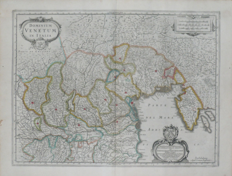
HONDIUS (Henricus);
[VENETIE] Dominium venetum in Italia.
Amsterdam 1639-1649 378 x 498 mm.
Référence libraire : LBW-1468
|
|
|
HONDIUS Hendrick (Amsterdam 1597 - 1651)
Patria del Friuli olim Forum Iulii
Carta tratta dell'Atlas sive cosmographicae meditationes de fabrica mundi curato da Hendrick Hondius. Basata sulla carta di Giovanni Antonio Magini pubblicata nel 1620 a Bologna. Nel 1604, Jodocus Hondius (1563-1612) - probabilmente tramite Cornelis Claesz - acquistò le matrici in rame dell'Atlas sive cosmographicae meditationes de fabrica mundi di Gerard Mercator all’asta. Aggiunse circa 40 mappe, comprese nuove mappe dei continenti e importanti mappe regionali delle Americhe, prima di pubblicare una nuova edizione dell’opera, nel 1606, in concorrenza con il Theatrum Orbis Terrarum di Ortelius. Poiché molte delle mappe erano più aggiornate, la raccolta di Mercator & Hondius sostituì effettivamente il Theatrum di Ortelius. L’atlante del 1606 include tutte le 107 mappe dell’edizione del 1595, oltre a 37 nuove mappe, abilmente incise dallo stesso Hondius. La seconda edizione della raccolta seguì già nel 1607/08, mentre la prima edizione in un’altra lingua, il francese, fu messa sul mercato nel 1609. Apparentemente questa fu considerata come la terza edizione, perché nel 1611 apparve l'Editio Quarta, con un totale di 150 mappe. Dopo la morte di Jodocus Hondius (1612) la sua vedova e i suoi figli continuarono la stampa dell’atlante. Jodocus Junior ( o Jodocus II, 1594-1629) produsse diverse ristampe tra il 1613 e il 1619, sempre con le stesse 150 mappe; nel 1619 furono invece aggiunte sei nuove mappe. Dopo il 1620 la pubblicazione venne curata da Hendrick (Henricus) Hondius (1597-1651), il secondo figlio di Jodocus senior. Varie edizioni apparvero, nel 1623, 1628 e 1630. Hendrick fu il primo ad apportare dei veri cambiamenti: nell’edizione del 1628 firmò alcune mappe di Mercatore con il proprio nome. Nel 1630, quando probabilmente stava già collaborando con suo cognato Johannes Janssonius, aggiunse nove nuove carte. Le carte dell'Italia, di derivazione maginiana, vengono stampate per la prima volta nel Theatrum Italiae in quo Eius Regna, Domina, Ducatus, Et Speciatim Illorum Provinciae, Tabulis Accuratissimis, Iam, De Novo in Lucem Editio, Describunter, Quorum Sequens Pagina Indicabit, stampato ad Amsterdam da Hendrick Hondius nel 1636. Sebbene con l'imprint di Hondius, la raccolta contiene anche carte firmate da Johannes Janssonius (cfr. Koeman, Atlas Neerlandici, vol. II pp. 379-380, Me 43). Acquaforte, bella coloritura coeva, in buono stato di conservazione. Map taken from the Atlas sive cosmographicae meditationes de fabrica mundi edited by Hendrick Hondius and based on the work by Giovanni Antonio Magini. In 1604, Jodocus Hondius (1563-1612) – probably trought Cornelis Claesz - bought the copperplates of Mercator’s Atlas sive cosmographicae meditationes de fabrica mundi at the auction of Gerard Jr.’s effects. He added about 40 maps, including new maps of the Continents and important regional maps of the Americas, before publishing a new edition of the Atlas, in 1606, in competition with Ortelius’ Theatrum Orbis Terrarum. As many of the maps were more up-to-date, the Mercator-Hondius Atlas effectively superseded Ortelius’ Theatrum. This atlas from 1606 include all 107 maps from the 1595 edition, as well as 37 new maps, skillfully engraved by Hondius, of various authors. The second edition of the Mercator-Hondius atlas followed as soon as 1607/08. The first edition in another language, French, was put on the market in 1609. Apparently this one was regarded as the third edition, because in 1611 Editio Quarta appeared with a total of 150 maps. After the death of Jodocus Hondius in 1612 his widow and sons continued the publication of the Atlas. For instance Jodocus Junior (1594-1629) produced several new editions of the Editio Quarta between 1613 and 1619, each with the same 150 maps. Finally in 1619 the last edition of this atlas followed, to which six new maps were added. After 1620 the publication of the Atlas was continued by Henricus Hondius (ca. 1596/97-1651), the second son of Jodocus senior. Various editions appeared, in 1623, 1628 and 1630. Henricus Hondius was the first to make some real changes: in the 1628 edition he provided some Mercator maps with his own name. In 1630, when he was probably already cooperating with his brother-in- law Johannes Janssonius, Henricus added nine new maps. The maps of Italy, derived from Magini, were first printed in the Theatrum Italiae in quo Eius Regna, Domina, Ducatus, Et Speciatim Illorum Provinciae, Tabulis Accuratissimis, Iam, De Novo in Lucem Editio, Describunter, Quorum Sequens Page Indicabit, printed in Amsterdam by Hendrick Hondius in 1636. Although imprinted by Hondius, the collection also contains maps signed by Johannes Janssonius (see Koeman, Atlas Neerlandici, vol. II pp. 379-380, Me 43). Copperplate, fine original colouring, good condition.

|
|
|
HONDIUS Hendrick (Amsterdam 1597 - 1651)
Signoria di Vercelli
Carta tratta dell'Atlas sive cosmographicae meditationes de fabrica mundi curato da Hendrick Hondius. Basata sulla carta di Giovanni Antonio Magini pubblicata nel 1620 a Bologna. Nel 1604, Jodocus Hondius (1563-1612) - probabilmente tramite Cornelis Claesz - acquistò le matrici in rame dell'Atlas sive cosmographicae meditationes de fabrica mundi di Gerard Mercator all’asta. Aggiunse circa 40 mappe, comprese nuove mappe dei continenti e importanti mappe regionali delle Americhe, prima di pubblicare una nuova edizione dell’opera, nel 1606, in concorrenza con il Theatrum Orbis Terrarum di Ortelius. Poiché molte delle mappe erano più aggiornate, la raccolta di Mercator & Hondius sostituì effettivamente il Theatrum di Ortelius. L’atlante del 1606 include tutte le 107 mappe dell’edizione del 1595, oltre a 37 nuove mappe, abilmente incise dallo stesso Hondius. La seconda edizione della raccolta seguì già nel 1607/08, mentre la prima edizione in un’altra lingua, il francese, fu messa sul mercato nel 1609. Apparentemente questa fu considerata come la terza edizione, perché nel 1611 apparve l'Editio Quarta, con un totale di 150 mappe. Dopo la morte di Jodocus Hondius (1612) la sua vedova e i suoi figli continuarono la stampa dell’atlante. Jodocus Junior ( o Jodocus II, 1594-1629) produsse diverse ristampe tra il 1613 e il 1619, sempre con le stesse 150 mappe; nel 1619 furono invece aggiunte sei nuove mappe. Dopo il 1620 la pubblicazione venne curata da Hendrick (Henricus) Hondius (1597-1651), il secondo figlio di Jodocus senior. Varie edizioni apparvero, nel 1623, 1628 e 1630. Hendrick fu il primo ad apportare dei veri cambiamenti: nell’edizione del 1628 firmò alcune mappe di Mercatore con il proprio nome. Nel 1630, quando probabilmente stava già collaborando con suo cognato Johannes Janssonius, aggiunse nove nuove carte. Le carte dell'Italia, di derivazione maginiana, vengono stampate per la prima volta nel Theatrum Italiae in quo Eius Regna, Domina, Ducatus, Et Speciatim Illorum Provinciae, Tabulis Accuratissimis, Iam, De Novo in Lucem Editio, Describunter, Quorum Sequens Pagina Indicabit, stampato ad Amsterdam da Hendrick Hondius nel 1636. Sebbene con l'imprint di Hondius, la raccolta contiene anche carte firmate da Johannes Janssonius (cfr. Koeman, Atlas Neerlandici, Me 43, vol. II pp. 379-380). Acquaforte, bella coloritura coeva, in buono stato di conservazione. Map taken from the Atlas sive cosmographicae meditationes de fabrica mundi edited by Hendrick Hondius and based on the work by Giovanni Antonio Magini. In 1604, Jodocus Hondius (1563-1612) – probably trought Cornelis Claesz - bought the copperplates of Mercator’s Atlas sive cosmographicae meditationes de fabrica mundi at the auction of Gerard Jr.’s effects. He added about 40 maps, including new maps of the Continents and important regional maps of the Americas, before publishing a new edition of the Atlas, in 1606, in competition with Ortelius’ Theatrum Orbis Terrarum. As many of the maps were more up-to-date, the Mercator-Hondius Atlas effectively superseded Ortelius’ Theatrum. This atlas from 1606 include all 107 maps from the 1595 edition, as well as 37 new maps, skillfully engraved by Hondius, of various authors. The second edition of the Mercator-Hondius atlas followed as soon as 1607/08. The first edition in another language, French, was put on the market in 1609. Apparently this one was regarded as the third edition, because in 1611 Editio Quarta appeared with a total of 150 maps. After the death of Jodocus Hondius in 1612 his widow and sons continued the publication of the Atlas. For instance Jodocus Junior (1594-1629) produced several new editions of the Editio Quarta between 1613 and 1619, each with the same 150 maps. Finally in 1619 the last edition of this atlas followed, to which six new maps were added. After 1620 the publication of the Atlas was continued by Henricus Hondius (ca. 1596/97-1651), the second son of Jodocus senior. Various editions appeared, in 1623, 1628 and 1630. Henricus Hondius was the first to make some real changes: in the 1628 edition he provided some Mercator maps with his own name. In 1630, when he was probably already cooperating with his brother-in- law Johannes Janssonius, Henricus added nine new maps. The maps of Italy, derived from Magini, were first printed in the Theatrum Italiae in quo Eius Regna, Domina, Ducatus, Et Speciatim Illorum Provinciae, Tabulis Accuratissimis, Iam, De Novo in Lucem Editio, Describunter, Quorum Sequens Page Indicabit, printed in Amsterdam by Hendrick Hondius in 1636. Although imprinted by Hondius, the collection also contains maps signed by Johannes Janssonius (see Koeman, Atlas Neerlandici, vol. II pp. 379-380, Me 43). Copperplate, fine original colouring, good condition.

|
|
|
HONDIUS Hendrick (Amsterdam 1597 - 1651)
Stato della Chiesa. Dominum Ecclesiasticum in Italia
Carta tratta dell'Atlas sive cosmographicae meditationes de fabrica mundi curato da Hendrick Hondius. Basata sulla carta di Giovanni Antonio Magini pubblicata nel 1620 a Bologna. Nel 1604, Jodocus Hondius (1563-1612) - probabilmente tramite Cornelis Claesz - acquistò le matrici in rame dell'Atlas sive cosmographicae meditationes de fabrica mundi di Gerard Mercator all’asta. Aggiunse circa 40 mappe, comprese nuove mappe dei continenti e importanti mappe regionali delle Americhe, prima di pubblicare una nuova edizione dell’opera, nel 1606, in concorrenza con il Theatrum Orbis Terrarum di Ortelius. Poiché molte delle mappe erano più aggiornate, la raccolta di Mercator & Hondius sostituì effettivamente il Theatrum di Ortelius. L’atlante del 1606 include tutte le 107 mappe dell’edizione del 1595, oltre a 37 nuove mappe, abilmente incise dallo stesso Hondius. La seconda edizione della raccolta seguì già nel 1607/08, mentre la prima edizione in un’altra lingua, il francese, fu messa sul mercato nel 1609. Apparentemente questa fu considerata come la terza edizione, perché nel 1611 apparve l'Editio Quarta, con un totale di 150 mappe. Dopo la morte di Jodocus Hondius (1612) la sua vedova e i suoi figli continuarono la stampa dell’atlante. Jodocus Junior ( o Jodocus II, 1594-1629) produsse diverse ristampe tra il 1613 e il 1619, sempre con le stesse 150 mappe; nel 1619 furono invece aggiunte sei nuove mappe. Dopo il 1620 la pubblicazione venne curata da Hendrick (Henricus) Hondius (1597-1651), il secondo figlio di Jodocus senior. Varie edizioni apparvero, nel 1623, 1628 e 1630. Hendrick fu il primo ad apportare dei veri cambiamenti: nell’edizione del 1628 firmò alcune mappe di Mercatore con il proprio nome. Nel 1630, quando probabilmente stava già collaborando con suo cognato Johannes Janssonius, aggiunse nove nuove carte. Le carte dell'Italia, di derivazione maginiana, vengono stampate per la prima volta nel Theatrum Italiae in quo Eius Regna, Domina, Ducatus, Et Speciatim Illorum Provinciae, Tabulis Accuratissimis, Iam, De Novo in Lucem Editio, Describunter, Quorum Sequens Pagina Indicabit, stampato ad Amsterdam da Hendrick Hondius nel 1636. Sebbene con l'imprint di Hondius, la raccolta contiene anche carte firmate da Johannes Janssonius (cfr. Koeman, Atlas Neerlandici, vol. II pp. 379-380, Me 43). Incisione in rame, ottime condizioni. Map taken from the Atlas sive cosmographicae meditationes de fabrica mundi edited by Hendrick Hondius and based on the work by Giovanni Antonio Magini. In 1604, Jodocus Hondius (1563-1612) – probably trought Cornelis Claesz - bought the copperplates of Mercator’s Atlas sive cosmographicae meditationes de fabrica mundi at the auction of Gerard Jr.’s effects. He added about 40 maps, including new maps of the Continents and important regional maps of the Americas, before publishing a new edition of the Atlas, in 1606, in competition with Ortelius’ Theatrum Orbis Terrarum. As many of the maps were more up-to-date, the Mercator-Hondius Atlas effectively superseded Ortelius’ Theatrum. This atlas from 1606 include all 107 maps from the 1595 edition, as well as 37 new maps, skillfully engraved by Hondius, of various authors. The second edition of the Mercator-Hondius atlas followed as soon as 1607/08. The first edition in another language, French, was put on the market in 1609. Apparently this one was regarded as the third edition, because in 1611 Editio Quarta appeared with a total of 150 maps. After the death of Jodocus Hondius in 1612 his widow and sons continued the publication of the Atlas. For instance Jodocus Junior (1594-1629) produced several new editions of the Editio Quarta between 1613 and 1619, each with the same 150 maps. Finally in 1619 the last edition of this atlas followed, to which six new maps were added. After 1620 the publication of the Atlas was continued by Henricus Hondius (ca. 1596/97-1651), the second son of Jodocus senior. Various editions appeared, in 1623, 1628 and 1630. Henricus Hondius was the first to make some real changes: in the 1628 edition he provided some Mercator maps with his own name. In 1630, when he was probably already cooperating with his brother-in- law Johannes Janssonius, Henricus added nine new maps. The maps of Italy, derived from Magini, were first printed in the Theatrum Italiae in quo Eius Regna, Domina, Ducatus, Et Speciatim Illorum Provinciae, Tabulis Accuratissimis, Iam, De Novo in Lucem Editio, Describunter, Quorum Sequens Page Indicabit, printed in Amsterdam by Hendrick Hondius in 1636. Although imprinted by Hondius, the collection also contains maps signed by Johannes Janssonius (see Koeman, Atlas Neerlandici, vol. II pp. 379-380, Me 43). Copperplate, fine original colouring, good condition. F. Ronca e A. Sorbini (a cura di) "Le antiche terre del Ducato di Spoleto", p. 66, 19.

|
|
|
HONDIUS Hendrick (Amsterdam 1597 - 1651)
Territorio Padovano
Carta tratta dell'Atlas sive cosmographicae meditationes de fabrica mundi curato da Hendrick Hondius. Basata sulla carta di Giovanni Antonio Magini pubblicata nel 1620 a Bologna. Nel 1604, Jodocus Hondius (1563-1612) - probabilmente tramite Cornelis Claesz - acquistò le matrici in rame dell'Atlas sive cosmographicae meditationes de fabrica mundi di Gerard Mercator all’asta. Aggiunse circa 40 mappe, comprese nuove mappe dei continenti e importanti mappe regionali delle Americhe, prima di pubblicare una nuova edizione dell’opera, nel 1606, in concorrenza con il Theatrum Orbis Terrarum di Ortelius. Poiché molte delle mappe erano più aggiornate, la raccolta di Mercator & Hondius sostituì effettivamente il Theatrum di Ortelius. L’atlante del 1606 include tutte le 107 mappe dell’edizione del 1595, oltre a 37 nuove mappe, abilmente incise dallo stesso Hondius. La seconda edizione della raccolta seguì già nel 1607/08, mentre la prima edizione in un’altra lingua, il francese, fu messa sul mercato nel 1609. Apparentemente questa fu considerata come la terza edizione, perché nel 1611 apparve l'Editio Quarta, con un totale di 150 mappe. Dopo la morte di Jodocus Hondius (1612) la sua vedova e i suoi figli continuarono la stampa dell’atlante. Jodocus Junior ( o Jodocus II, 1594-1629) produsse diverse ristampe tra il 1613 e il 1619, sempre con le stesse 150 mappe; nel 1619 furono invece aggiunte sei nuove mappe. Dopo il 1620 la pubblicazione venne curata da Hendrick (Henricus) Hondius (1597-1651), il secondo figlio di Jodocus senior. Varie edizioni apparvero, nel 1623, 1628 e 1630. Hendrick fu il primo ad apportare dei veri cambiamenti: nell’edizione del 1628 firmò alcune mappe di Mercatore con il proprio nome. Nel 1630, quando probabilmente stava già collaborando con suo cognato Johannes Janssonius, aggiunse nove nuove carte. Le carte dell'Italia, di derivazione maginiana, vengono stampate per la prima volta nel Theatrum Italiae in quo Eius Regna, Domina, Ducatus, Et Speciatim Illorum Provinciae, Tabulis Accuratissimis, Iam, De Novo in Lucem Editio, Describunter, Quorum Sequens Pagina Indicabit, stampato ad Amsterdam da Hendrick Hondius nel 1636. Sebbene con l'imprint di Hondius, la raccolta contiene anche carte firmate da Johannes Janssonius (cfr. Koeman, Atlas Neerlandici, vol. II pp. 379-380, Me 43). Acquaforte, bella coloritura coeva, in buono stato di conservazione Map taken from the Atlas sive cosmographicae meditationes de fabrica mundi edited by Hendrick Hondius and based on the work by Giovanni Antonio Magini. In 1604, Jodocus Hondius (1563-1612) – probably trought Cornelis Claesz - bought the copperplates of Mercator’s Atlas sive cosmographicae meditationes de fabrica mundi at the auction of Gerard Jr.’s effects. He added about 40 maps, including new maps of the Continents and important regional maps of the Americas, before publishing a new edition of the Atlas, in 1606, in competition with Ortelius’ Theatrum Orbis Terrarum. As many of the maps were more up-to-date, the Mercator-Hondius Atlas effectively superseded Ortelius’ Theatrum. This atlas from 1606 include all 107 maps from the 1595 edition, as well as 37 new maps, skillfully engraved by Hondius, of various authors. The second edition of the Mercator-Hondius atlas followed as soon as 1607/08. The first edition in another language, French, was put on the market in 1609. Apparently this one was regarded as the third edition, because in 1611 Editio Quarta appeared with a total of 150 maps. After the death of Jodocus Hondius in 1612 his widow and sons continued the publication of the Atlas. For instance Jodocus Junior (1594-1629) produced several new editions of the Editio Quarta between 1613 and 1619, each with the same 150 maps. Finally in 1619 the last edition of this atlas followed, to which six new maps were added. After 1620 the publication of the Atlas was continued by Henricus Hondius (ca. 1596/97-1651), the second son of Jodocus senior. Various editions appeared, in 1623, 1628 and 1630. Henricus Hondius was the first to make some real changes: in the 1628 edition he provided some Mercator maps with his own name. In 1630, when he was probably already cooperating with his brother-in- law Johannes Janssonius, Henricus added nine new maps. The maps of Italy, derived from Magini, were first printed in the Theatrum Italiae in quo Eius Regna, Domina, Ducatus, Et Speciatim Illorum Provinciae, Tabulis Accuratissimis, Iam, De Novo in Lucem Editio, Describunter, Quorum Sequens Page Indicabit, printed in Amsterdam by Hendrick Hondius in 1636. Although imprinted by Hondius, the collection also contains maps signed by Johannes Janssonius (see Koeman, Atlas Neerlandici, vol. II pp. 379-380, Me 43). Copperplate, fine original colouring, good condition. Koeman Me 43, 368.

|
|
|
HONDIUS Hendrick (Amsterdam 1597 - 1651)
Territorium Vicentinum
Carta tratta dell'Atlas sive cosmographicae meditationes de fabrica mundi curato da Hendrick Hondius. Basata sulla carta di Giovanni Antonio Magini pubblicata nel 1620 a Bologna. Nel 1604, Jodocus Hondius (1563-1612) - probabilmente tramite Cornelis Claesz - acquistò le matrici in rame dell'Atlas sive cosmographicae meditationes de fabrica mundi di Gerard Mercator all’asta. Aggiunse circa 40 mappe, comprese nuove mappe dei continenti e importanti mappe regionali delle Americhe, prima di pubblicare una nuova edizione dell’opera, nel 1606, in concorrenza con il Theatrum Orbis Terrarum di Ortelius. Poiché molte delle mappe erano più aggiornate, la raccolta di Mercator & Hondius sostituì effettivamente il Theatrum di Ortelius. L’atlante del 1606 include tutte le 107 mappe dell’edizione del 1595, oltre a 37 nuove mappe, abilmente incise dallo stesso Hondius. La seconda edizione della raccolta seguì già nel 1607/08, mentre la prima edizione in un’altra lingua, il francese, fu messa sul mercato nel 1609. Apparentemente questa fu considerata come la terza edizione, perché nel 1611 apparve l'Editio Quarta, con un totale di 150 mappe. Dopo la morte di Jodocus Hondius (1612) la sua vedova e i suoi figli continuarono la stampa dell’atlante. Jodocus Junior ( o Jodocus II, 1594-1629) produsse diverse ristampe tra il 1613 e il 1619, sempre con le stesse 150 mappe; nel 1619 furono invece aggiunte sei nuove mappe. Dopo il 1620 la pubblicazione venne curata da Hendrick (Henricus) Hondius (1597-1651), il secondo figlio di Jodocus senior. Varie edizioni apparvero, nel 1623, 1628 e 1630. Hendrick fu il primo ad apportare dei veri cambiamenti: nell’edizione del 1628 firmò alcune mappe di Mercatore con il proprio nome. Nel 1630, quando probabilmente stava già collaborando con suo cognato Johannes Janssonius, aggiunse nove nuove carte. Le carte dell'Italia, di derivazione maginiana, vengono stampate per la prima volta nel Theatrum Italiae in quo Eius Regna, Domina, Ducatus, Et Speciatim Illorum Provinciae, Tabulis Accuratissimis, Iam, De Novo in Lucem Editio, Describunter, Quorum Sequens Pagina Indicabit, stampato ad Amsterdam da Hendrick Hondius nel 1636. Sebbene con l'imprint di Hondius, la raccolta contiene anche carte firmate da Johannes Janssonius (cfr. Koeman, Atlas Neerlandici, vol. II pp. 379-380, Me 43). Acquaforte, bella coloritura coeva, in buono stato di conservazione. Map taken from the Atlas sive cosmographicae meditationes de fabrica mundi edited by Hendrick Hondius and based on the work by Giovanni Antonio Magini. In 1604, Jodocus Hondius (1563-1612) – probably trought Cornelis Claesz - bought the copperplates of Mercator’s Atlas sive cosmographicae meditationes de fabrica mundi at the auction of Gerard Jr.’s effects. He added about 40 maps, including new maps of the Continents and important regional maps of the Americas, before publishing a new edition of the Atlas, in 1606, in competition with Ortelius’ Theatrum Orbis Terrarum. As many of the maps were more up-to-date, the Mercator-Hondius Atlas effectively superseded Ortelius’ Theatrum. This atlas from 1606 include all 107 maps from the 1595 edition, as well as 37 new maps, skillfully engraved by Hondius, of various authors. The second edition of the Mercator-Hondius atlas followed as soon as 1607/08. The first edition in another language, French, was put on the market in 1609. Apparently this one was regarded as the third edition, because in 1611 Editio Quarta appeared with a total of 150 maps. After the death of Jodocus Hondius in 1612 his widow and sons continued the publication of the Atlas. For instance Jodocus Junior (1594-1629) produced several new editions of the Editio Quarta between 1613 and 1619, each with the same 150 maps. Finally in 1619 the last edition of this atlas followed, to which six new maps were added. After 1620 the publication of the Atlas was continued by Henricus Hondius (ca. 1596/97-1651), the second son of Jodocus senior. Various editions appeared, in 1623, 1628 and 1630. Henricus Hondius was the first to make some real changes: in the 1628 edition he provided some Mercator maps with his own name. In 1630, when he was probably already cooperating with his brother-in- law Johannes Janssonius, Henricus added nine new maps. The maps of Italy, derived from Magini, were first printed in the Theatrum Italiae in quo Eius Regna, Domina, Ducatus, Et Speciatim Illorum Provinciae, Tabulis Accuratissimis, Iam, De Novo in Lucem Editio, Describunter, Quorum Sequens Page Indicabit, printed in Amsterdam by Hendrick Hondius in 1636. Although imprinted by Hondius, the collection also contains maps signed by Johannes Janssonius (see Koeman, Atlas Neerlandici, vol. II pp. 379-380, Me 43). Copperplate, fine original colouring, good condition.

|
|
|
Hondius Henricum
Stato della Chiesa - Dominium Ecclesiasticum in Italia

|
|
|
Hondius Iodici - Gerardi Mercatoris
Italia
Carta geografica dell'Italia, antica ed originale, Autore: Hondius Iodici - Gerardi Mercatoris. Luogo: Italia. Anno: 1630. Tecnica: acquaforte. Dimensioni: 183x252. Nel margine alto la scritta "L'Italie". Piccoli restauri

|
|
|
HONDIUS Jodocus (Amsterdam 1563 - 1612)
Aprutium
Carta tratta dalla prima edizione della "Cosmographia Universalis" di Paul Merula , stampata ad Amsterdam nel 1605. Le mappe usate per illustrare la prima edizione della Cosmografia di Merula sono realizzate nel 1598 da Jodocus Hondius e Pieter Van den Keere (Kaerius) e quidni utilizzate dall'editore Cornelis Claesz per illustrare lavori di Apian, Linschoten e Merula. Incisione in rame, inserita in una pagina di testo, in perfette condizioni. Geographic map taken from Merula's "Cosmographiae generalis libri tres". Copperplate, inserted in a text page, in excellent condition.

|
|
|
HONDIUS Jodocus (Amsterdam 1563 - 1612)
Corsica & Sardinia
Mappa tratta dall’Atlas minor Gerardi Mercatoris a I. Hondio plurimis aeneis tabulis auctus et illustratus. Apparso per la prima volta nel 1607, l'atlante Mercator-Hondius-Mercator fu un successo a livello europeo, con edizioni pubblicate sia in latino che in diverse altre lingue. Le varie edizioni furono curate da Jodocus Hondius e poi da Jan Janssonius, e contenevano un numero crescente di mappe. "Shortly after the publication of the big folio-atlases the need was apparantly felt for a smaller-sized atlas, one that would be handier, and, above all, cheaper, so that a larger public might have access to the use of maps. The publication of the Atlas Minor appeared to be a great success for Hondius; the first Latin edition was in great demand. The copperplates of the first atlases minor were most almost certainly engraved by Jodocus Hondius himself. After 1621, the copperplates of the Atlas Minor were sold to a London editor. Firstly, they appeared in Purchas his Pilgrinies, printed in 1625 by William Stansby for Henry Featherstone. Next they were used for the translation of the Mercator-atlas, printed in small folio under the title Historia mundi, or Mercators atlas, by Thomas Cotes for Michael Sparke and Samuel Cartwight in 1635". (cf. Koeman II Me 191). "As with the Theatrum of Abraham Ortelius, Jodocus Hondius planned a reduced size version of Gerard Mercator's folio atlas. Just one year after his first edition he published his Latin text Atlas Minor in collaboration with Jan Jansz. and Cormelis Claesz. The arrangement between these three is not understood clearly but Hondius is believed to have been the owner of the copperplates. Cartographically this is taken directly from the folio maps by Hondius in 1606 [..]. with the inevitable loss of detail due to the reduction” (cf. Burden, The Mapping of North America, 153). Incisione su rame, finemente colorata a mano, in buone condizioni. Bibliografia Koeman II Me 191; cfr. Phillips 426; cfr. Burden 153. Map taken from Atlas minor Gerardi Mercatoris a I. Hondio plurimis aeneis tabulis auctus et illustratus. Appearing first in 1607, the Hondius-Mercator ‘smaller’ atlas was a Europe-wide success, with editions published both in Latin and in several vernaculars. The various editions were edited by Jodocus Hondius and then Jan Janssonius, and contained an increasing number of maps. "Shortly after the publication of the big folio-atlases the need was apparantly felt for a smaller-sized atlas, one that would be handier, and, above all, cheaper, so that a larger public might have access to the use of maps. The publication of the Atlas Minor appeared to be a great success for Hondius; the first Latin edition was in great demand. The copperplates of the first atlases minor were most almost certainly engraved by Jodocus Hondius himself. After 1621, the copperplates of the Atlas Minor were sold to a London editor. Firstly, they appeared in Purchas his Pilgrinies, printed in 1625 by William Stansby for Henry Featherstone. Next they were used for the translation of the Mercator-atlas, printed in small folio under the title Historia mundi, or Mercators atlas, by Thomas Cotes for Michael Sparke and Samuel Cartwight in 1635". (cf. Koeman II Me 191). "As with the Theatrum of Abraham Ortelius, Jodocus Hondius planned a reduced size version of Gerard Mercator's folio atlas. Just one year after his first edition he published his Latin text Atlas Minor in collaboration with Jan Jansz. and Cormelis Claesz. The arrangement between these three is not understood clearly but Hondius is believed to have been the owner of the copperplates. Cartographically this is taken directly from the folio maps by Hondius in 1606 [..]. with the inevitable loss of detail due to the reduction” (cf. Burden, The Mapping of North America, 153). Copperplate with fine colouring, good conditions. Bibliografia Koeman II Me 191; cf. Phillips 426; cf. Burden 153.

|
|
|
HONDIUS Jodocus (Amsterdam 1563 - 1612)
Cremonensis Ager
Carta tratta dalla prima edizione della "Cosmographia Universalis" di Paul Merula , stampata ad Amsterdam nel 1605. Le mappe usate per illustrare la prima edizione della Cosmografia di Merula sono realizzate nel 1598 da Jodocus Hondius e Pieter Van den Keere (Kaerius) e quidni utilizzate dall'editore Cornelis Claesz per illustrare lavori di Apian, Linschoten e Merula. Incisione in rame, inserita uin una pagina di testo, in perfette condizioni. Taken from the first edition of "Cosmographia Universalis" by Paul Merula, printed in Amsterdam in 1605.The map was first issued in 1598 by Cornelis Claesz and engraved and realized by Jodocus Hondius and Pietre vand den Keere (Kaerius). Claesz used the plate to illustrate various works he published by Peter Apian, Jan van Linschoten, Paul Merula and others. Copperplate, inset in a page text, very good conditions. King pp.80/81

|
|
|
HONDIUS Jodocus (Amsterdam 1563 - 1612)
Forum Iulii
Carta tratta dalla prima edizione della "Cosmographia Universalis" di Paul Merula , stampata ad Amsterdam nel 1605. Le mappe usate per illustrare la prima edizione della Cosmografia di Merula sono realizzate nel 1598 da Jodocus Hondius e Pieter Van den Keere (Kaerius) e quidni utilizzate dall'editore Cornelis Claesz per illustrare lavori di Apian, Linschoten e Merula. Incisione in rame, inserita uin una pagina di testo, in perfette condizioni. Taken from the first edition of "Cosmographia Universalis" by Paul Merula, printed in Amsterdam in 1605.The map was first issued in 1598 by Cornelis Claesz and engraved and realized by Jodocus Hondius and Pietre vand den Keere (Kaerius). Claesz used the plate to illustrate various works he published by Peter Apian, Jan van Linschoten, Paul Merula and others. Copperplate, inset in a page text, very good conditions. King pp.80/81

|
|
|
HONDIUS Jodocus (Amsterdam 1563 - 1612)
Genovesato
Carta geografica della Liguria, per la prima volta pubblicata in "Nova et accurata Italia" edito a Leida nel 1627.Tuttavia questo esemplare non presenta il testo al verso che si trova in tutte le carte tratte dall’atlante del Hondius. Si tratta di una di una rara edizione successiva, realizzata ad Amsterdam da Henri du Sauzet nel 1734 nel "Atlas Portatif" raccolta di 285 carte geografiche di diversi autori.Incisione in rame, bella coloritura coeva dei contorni. Molto rara. Taken from the "Nova et accurata Italia" published in Leyden by Hondius in 1627. Later edition without text on the back, printed in Amsterdam by Henri du Sauzet in 1734 in his "Atlas Portatif".Copperplate with original hand colour, in very good conditions. Very rare.

|
|
|
HONDIUS Jodocus (Amsterdam 1563 - 1612)
Marchia Anconae olim Picenum
Carta tratta dalla prima edizione della "Cosmographia Universalis" di Paul Merula , stampata ad Amsterdam nel 1605. Le mappe usate per illustrare la prima edizione della Cosmografia di Merula sono realizzate nel 1598 da Jodocus Hondius e Pieter Van den Keere (Kaerius) e quidni utilizzate dall'editore Cornelis Claesz per illustrare lavori di Apian, Linschoten e Merula. Incisione in rame, inserita uin una pagina di testo, in perfette condizioni. Taken from the first edition of "Cosmographia Universalis" by Paul Merula, printed in Amsterdam in 1605.The map was first issued in 1598 by Cornelis Claesz and engraved and realized by Jodocus Hondius and Pietre vand den Keere (Kaerius). Claesz used the plate to illustrate various works he published by Peter Apian, Jan van Linschoten, Paul Merula and others. Copperplate, inset in a page text, very good conditions. King pp. 80/81. G. Mangani - F. Mariano, Il disegno del territorio, p. 108 n. 4

|
|
|
HONDIUS Jodocus (Amsterdam 1563 - 1612)
Patavinum. Ter
Carta tratta dalla prima edizione della "Cosmographia Universalis" di Paul Merula , stampata ad Amsterdam nel 1605. Le mappe usate per illustrare la prima edizione della Cosmografia di Merula sono realizzate nel 1598 da Jodocus Hondius e Pieter Van den Keere (Kaerius) e quidni utilizzate dall'editore Cornelis Claesz per illustrare lavori di Apian, Linschoten e Merula. Incisione in rame, inserita uin una pagina di testo, in perfette condizioni. Taken from the first edition of "Cosmographia Universalis" by Paul Merula, printed in Amsterdam in 1605.The map was first issued in 1598 by Cornelis Claesz and engraved and realized by Jodocus Hondius and Pietre vand den Keere (Kaerius). Claesz used the plate to illustrate various works he published by Peter Apian, Jan van Linschoten, Paul Merula and others. Copperplate, inset in a page text, very good conditions. King pp80/81

|
|
|
HONDIUS Jodocus (Amsterdam 1563 - 1612)
Romanum territorium
Carta tratta dalla prima edizione della "Cosmographia Universalis" di Paul Merula , stampata ad Amsterdam nel 1605. Le mappe usate per illustrare la prima edizione della Cosmografia di Merula sono realizzate nel 1598 da Jodocus Hondius e Pieter Van den Keere (Kaerius) e quidni utilizzate dall'editore Cornelis Claesz per illustrare lavori di Apian, Linschoten e Merula. Incisione in rame, inserita uin una pagina di testo, in perfette condizioni. Taken from the first edition of "Cosmographia Universalis" by Paul Merula, printed in Amsterdam in 1605. The map was first issued in 1598 by Cornelis Claesz and engraved and realized by Jodocus Hondius and Pietre vand den Keere (Kaerius). Claesz used the plate to illustrate various works he published by Peter Apian, Jan van Linschoten, Paul Merula and others. Copperplate, inset in a page text, very good conditions. King pp.80/81

|
|
|
HONDIUS Jodocus (Amsterdam 1563 - 1612)
Sabaudia Ducatus - La Savoie
Carta geografica della Liguria, per la prima volta pubblicata in "Nova et accurata Italia" edito a Leida nel 1627.Tuttavia questo esemplare non presenta il testo al verso che si trova in tutte le carte tratte dall’atlante del Hondius. Si tratta di una di una rara edizione successiva, realizzata ad Amsterdam da Henri du Sauzet nel 1734 nel "Atlas Portatif" raccolta di 285 carte geografiche di diversi autori.Incisione in rame, bella coloritura coeva dei contorni. Molto rara. Taken from the "Nova et accurata Italia" published in Leyden by Hondius in 1627. Later edition without text on the back, printed in Amsterdam by Henri du Sauzet in 1734 in his "Atlas Portatif".Copperplate with original hand colour, in very good conditions. Very rare.

|
|
|
HONDIUS Jodocus (Amsterdam 1563 - 1612)
Veronensis Ager
Carta tratta dalla prima edizione della "Cosmographia Universalis" di Paul Merula , stampata ad Amsterdam nel 1605. Le mappe usate per illustrare la prima edizione della Cosmografia di Merula sono realizzate nel 1598 da Jodocus Hondius e Pieter Van den Keere (Kaerius) e quidni utilizzate dall'editore Cornelis Claesz per illustrare lavori di Apian, Linschoten e Merula. Incisione in rame, inserita uin una pagina di testo, in perfette condizioni. Taken from the first edition of "Cosmographia Universalis" by Paul Merula, printed in Amsterdam in 1605.The map was first issued in 1598 by Cornelis Claesz and engraved and realized by Jodocus Hondius and Pietre vand den Keere (Kaerius). Claesz used the plate to illustrate various works he published by Peter Apian, Jan van Linschoten, Paul Merula and others. Copperplate, inset in a page text, very good conditions. King pp. 80/81

|
|
|
HONDIUS Jr. Jodocus (Amsterdam 1594 -1629)
Ancona
Veduta tratta dal Nova et accurata Italiae hodiernae descriptio in qua omnium eius regionum, vrbium, pagorum, dominiorum, castellorum, montium, fluviorum, fontium, lacuum, et portuum, historia exhibetur. Geographicis tabulis et vrbium praecipuarum iconibus illustrata a Iudoco Hondio addita est Siciliae, Sardiniae, Corsicae, et itinerariorum per Italiam brevis delineatio, stampato a Leida dalla tipografia Elzevir nel 1627. Si tratta di un atlante geografico unito ad una raccolta di cartografia urbana, esclusivamente dedicato alla penisola. L’opera consta di 31 carte geografiche e 67 vedute o piante di città. Le carte derivano dall’Atlas Minor del Mercator, mentre la cartografia urbana è basata sui modelli introdotti a Venezia da Francesco Valegio e da quelli del Civitates Orbis Terrarum di G.Braun e F. Hogenberg. L’opera è relativa al periodo in cui Jodocus Hondius II si era appena diviso dal fratello Hendrick. Secondo la letteratura esisterebbe una prima edizione della raccolta, stampata ad Amsterdam nel 1626. Incisione in rame, finemente colorata a mano, in ottimo stato di conservazione. Bibliografia Cremonini, pp. 23/25, n. 18. Plate taken from Nova et accurata Italiae hodiernae descriptio in qua omnium eius regionum, vrbium, pagorum, dominiorum, castellorum, montium, fluviorum, fontium, lacuum, et portuum, historia exhibetur. Geographicis tabulis et vrbium praecipuarum iconibus illustrata a Iudoco Hondio addita est Siciliae, Sardiniae, Corsicae, et itinerariorum per Italiam brevis delineatio, printed in Leiden by the printing house Elzevir in 1627. This is a geographical atlas combined with a town book, exclusively dedicated to Italy. The work consists of 31 maps and 67 views or plans of cities. The maps derive from Mercator's Atlas Minor, while the plans are based on the models introduced in Venice by Francesco Valegio and those of Civitates Orbis Terrarum by G. Braun and F. Hogenberg. The work is related to the period in which Jodocus Hondius II had just separated from his brother Hendrick. According to the literature there is a first edition of the collection, printed in Amsterdam in 1626. Copper engraving, finely hand-colored, in excellent condition. Literature Cremonini, pp. 23/25, n. 18; Fossati Bellani; n. 320. Willems; n. 279.

|
|
|
HONDIUS Jr. Jodocus (Amsterdam 1594 -1629)
Brixensis Episcopatus
Carta geografica tratta dal "Tabularum Geographicarum contractarum libri septem" di Petrus Bertius, edizione latina del 1616.L'opera contiene 219 carte che illustrano questa nuova versione della geografia del Bertius, per la prima volta pubblicata nel 1612 con le carte di Barent Langenes. Le carte derivano dal grande Mercator/Hondius atlas, delle quali molte rappresentano una semplice riduzione. Incisione in rame, carta leggermente brunita, per il resto in ottimo stato di conservazione. Map taken from the "Tabularum Geographicarum contractarum libri septem" by Petrus Bertius, Latin edition of 1616.The work contains 219 maps illustrating this new version of the geography of Bertius, first published in 1612 with the maps by Barent Langenes.The maps come after from large Mercator/Hondius Atlas, of which many represent a simple reduction."After the death of Cornelis Claesz in 1609, Jodocus Hondius II became the new publisher of the work, composed by 7 parts in 1, with engraved title-page and 220 full-page engraved maps in text. All the maps were newly engraved and slightly larger in size, because Hondius was not able to acquire the original plates. With the new plates the work was definitely improved and enjoyed a growing demand of the public, which at that time had the choice between the Atlas Minor by Mercator and Bertius' Tabularum Geographicarum. The 219 plates, with the oval world map appearing twice, were produced to illustrate a new version of the geography of Bertius, published in 1616. According to King, their correct attribution is by Hondius, after Mercator and Hondius, taken from Bertius, who was only responsible for revising his text again". [cf. G. King, Miniature Antique Maps]Copper engraving, slightly burnished paper, otherwise in excellent condition. Bibliografia: Koeman, II Lan 11B; J; King pagg. 96/98.

|
|
|
HONDIUS Jr. Jodocus (Amsterdam 1594 -1629)
Comitatus Molisy et Capitaneata
Veduta tratta dal Nova et accurata Italiae hodiernae descriptio in qua omnium eius regionum, vrbium, pagorum, dominiorum, castellorum, montium, fluviorum, fontium, lacuum, et portuum, historia exhibetur. Geographicis tabulis et vrbium praecipuarum iconibus illustrata a Iudoco Hondio addita est Siciliae, Sardiniae, Corsicae, et itinerariorum per Italiam brevis delineatio, stampato a Leida dalla tipografia Elzevir nel 1627. Si tratta di un atlante geografico unito ad una raccolta di cartografia urbana, esclusivamente dedicato alla penisola. L’opera consta di 31 carte geografiche e 67 vedute o piante di città. Le carte derivano dall’Atlas Minor del Mercator, mentre la cartografia urbana è basata sui modelli introdotti a Venezia da Francesco Valegio e da quelli del Civitates Orbis Terrarum di G.Braun e F. Hogenberg. L’opera è relativa al periodo in cui Jodocus Hondius II si era appena diviso dal fratello Hendrick. Secondo la letteratura esisterebbe una prima edizione della raccolta, stampata ad Amsterdam nel 1626. Incisione in rame, finemente colorata a mano, in ottimo stato di conservazione. Bibliografia Cremonini, pp. 23/25, n. 18; Fossati Bellani; n. 320; Willems; n. 279. Plate taken from Nova et accurata Italiae hodiernae descriptio in qua omnium eius regionum, vrbium, pagorum, dominiorum, castellorum, montium, fluviorum, fontium, lacuum, et portuum, historia exhibetur. Geographicis tabulis et vrbium praecipuarum iconibus illustrata a Iudoco Hondio addita est Siciliae, Sardiniae, Corsicae, et itinerariorum per Italiam brevis delineatio, printed in Leiden by the printing house Elzevir in 1627. This is a geographical atlas combined with a town book, exclusively dedicated to Italy. The work consists of 31 maps and 67 views or plans of cities. The maps derive from Mercator's Atlas Minor, while the plans are based on the models introduced in Venice by Francesco Valegio and those of Civitates Orbis Terrarum by G. Braun and F. Hogenberg. The work is related to the period in which Jodocus Hondius II had just separated from his brother Hendrick. According to the literature there is a first edition of the collection, printed in Amsterdam in 1626. Copper engraving, finely hand-colored, in excellent condition. Literature Cremonini, pp. 23/25, n. 18; Fossati Bellani; n. 320. Willems; n. 279. Cremonini p.23/25, 18.

|
|
|
HONDIUS Jr. Jodocus (Amsterdam 1594 -1629)
Crema
Carta geografica prepararata per il "Tabularum Geographicarum contractarum libri septem" di Petrus Bertius, edizione latina del 1616.L'opera contiene 219 carte che illustrano questa nuova versione della geografia del Bertius, per la prima volta pubblicata nel 1612 con le carte di Barent Langenes. Le carte derivano dal grande Mercator/Hondius atlas, delle quali molte rappresentano una semplice riduzione. Esemplare tratto da "Paulli Cosmographiae generalis libri tres: item Geographiae particularis libri quatuor: quibus Europa in genere; speciatim Hispania, Gallia, Italia, describuntur. Cum tabulis geographicis aeneis multo quam antheac accuratioribus. Amsterodami, apud Iudocum Hondium, 1621 (Lugduni Batavorum, typis Isaaci Elzevier Academiae typographi; [Amsterdam], sumptibus Iudoci Hondii, 1620".Incisione in rame, finemente colorata a mano, carta leggermente brunita, per il resto in ottimo stato di conservazione. Carta geografica prepararata per il "Tabularum Geographicarum contractarum libri septem" di Petrus Bertius, edizione latina del 1616.L'opera contiene 219 carte che illustrano questa nuova versione della geografia del Bertius, per la prima volta pubblicata nel 1612 con le carte di Barent Langenes. Le carte derivano dal grande Mercator/Hondius atlas, delle quali molte rappresentano una semplice riduzione. Esemplare tratto da "Paulli Cosmographiae generalis libri tres: item Geographiae particularis libri quatuor: quibus Europa in genere; speciatim Hispania, Gallia, Italia, describuntur. Cum tabulis geographicis aeneis multo quam antheac accuratioribus. Amsterodami, apud Iudocum Hondium, 1621 (Lugduni Batavorum, typis Isaaci Elzevier Academiae typographi; [Amsterdam], sumptibus Iudoci Hondii, 1620".Incisione in rame, finemente colorata a mano, carta leggermente brunita, per il resto in ottimo stato di conservazione.

|
|
|
HONDIUS Jr. Jodocus (Amsterdam 1594 -1629)
Cremonensis Ager
Carta geografica prepararata per il "Tabularum Geographicarum contractarum libri septem" di Petrus Bertius, edizione latina del 1616.L'opera contiene 219 carte che illustrano questa nuova versione della geografia del Bertius, per la prima volta pubblicata nel 1612 con le carte di Barent Langenes. Le carte derivano dal grande Mercator/Hondius atlas, delle quali molte rappresentano una semplice riduzione. Esemplare tratto da "Paulli Cosmographiae generalis libri tres: item Geographiae particularis libri quatuor: quibus Europa in genere; speciatim Hispania, Gallia, Italia, describuntur. Cum tabulis geographicis aeneis multo quam antheac accuratioribus. Amsterodami, apud Iudocum Hondium, 1621 (Lugduni Batavorum, typis Isaaci Elzevier Academiae typographi; [Amsterdam], sumptibus Iudoci Hondii, 1620".Incisione in rame, finemente colorata a mano, carta leggermente brunita, per il resto in ottimo stato di conservazione. Carta geografica prepararata per il "Tabularum Geographicarum contractarum libri septem" di Petrus Bertius, edizione latina del 1616.L'opera contiene 219 carte che illustrano questa nuova versione della geografia del Bertius, per la prima volta pubblicata nel 1612 con le carte di Barent Langenes. Le carte derivano dal grande Mercator/Hondius atlas, delle quali molte rappresentano una semplice riduzione. Esemplare tratto da "Paulli Cosmographiae generalis libri tres: item Geographiae particularis libri quatuor: quibus Europa in genere; speciatim Hispania, Gallia, Italia, describuntur. Cum tabulis geographicis aeneis multo quam antheac accuratioribus. Amsterodami, apud Iudocum Hondium, 1621 (Lugduni Batavorum, typis Isaaci Elzevier Academiae typographi; [Amsterdam], sumptibus Iudoci Hondii, 1620".Incisione in rame, finemente colorata a mano, carta leggermente brunita, per il resto in ottimo stato di conservazione.

|
|
|
HONDIUS Jr. Jodocus (Amsterdam 1594 -1629)
Elba
Carta geografica tratta dal Tabularum Geographicarum contractarum libri septem di Petrus Bertius, edizione latina del 1616. L'opera contiene 219 carte che illustrano questa nuova versione della geografia del Bertius, per la prima volta pubblicata nel 1612 con le carte di Barent Langenes. Le carte derivano dal grande atlante di Mercator/Hondius, delle quali molte rappresentano una semplice riduzione. "After the death of Cornelis Claesz in 1609, Jodocus Hondius II became the new publisher of the work, composed by 7 parts in 1, with engraved title-page and 220 full-page engraved maps in text. All the maps were newly engraved and slightly larger in size, because Hondius was not able to acquire the original plates. With the new plates the work was definitely improved and enjoyed a growing demand of the public, which at that time had the choice between the Atlas Minor by Mercator and Bertius' Tabularum Geographicarum. The 219 plates, with the oval world map appearing twice, were produced to illustrate a new version of the geography of Bertius, published in 1616. According to King, their correct attribution is by Hondius, after Mercator and Hondius, taken from Bertius, who was only responsible for revising his text again" [cfr. G. King, Miniature Antique Maps]. Incisione in rame, perfette condizioni. A superior rival to the pocket Ortelius atlas appeared about 1598, under the imprint of Barent Langenes and Cornelis Claesz. Claesz also published the Tabularum Geographicarum contractarum libri septem, edition with texy by Petrus Bertius, in 1600. After the death of Cornelis Claesz in 1609, Jodocus Hondius II became the new publisher of the work, composed by 7 parts in 1, with engraved title-page and 220 full-page engraved maps in text. All the maps were newly engraved and slightly larger in size, because Hondius was not able to acquire the original plates. With the new plates the work was definitely improved and enjoyed a growing demand of the public, which at that time had the choice between the Atlas Minor by Mercator and Bertius' Tabularum Geographicarum. The 219 plates, with the oval world map appearing twice, were produced to illustrate a new version of the geography of Bertius, published in 1616. According to King, their correct attribution is by Hondius, after Mercator and Hondius, taken from Bertius, who was only responsible for revising his text again. "After the death of Cornelis Claesz in 1609, Jodocus Hondius II became the new publisher of the work, composed by 7 parts in 1, with engraved title-page and 220 full-page engraved maps in text. All the maps were newly engraved and slightly larger in size, because Hondius was not able to acquire the original plates. With the new plates the work was definitely improved and enjoyed a growing demand of the public, which at that time had the choice between the Atlas Minor by Mercator and Bertius' Tabularum Geographicarum. The 219 plates, with the oval world map appearing twice, were produced to illustrate a new version of the geography of Bertius, published in 1616. According to King, their correct attribution is by Hondius, after Mercator and Hondius, taken from Bertius, who was only responsible for revising his text again" [cf. G. King, Miniature Antique Maps]. Copperplate, in very good conditions. Bibliografia: Koeman, II Lan 11B; J; King pagg. 96/98.

|
|
|
HONDIUS Jr. Jodocus (Amsterdam 1594 -1629)
Fanum
Veduta tratta dal Nova et accurata Italiae hodiernae descriptio in qua omnium eius regionum, vrbium, pagorum, dominiorum, castellorum, montium, fluviorum, fontium, lacuum, et portuum, historia exhibetur. Geographicis tabulis et vrbium praecipuarum iconibus illustrata a Iudoco Hondio addita est Siciliae, Sardiniae, Corsicae, et itinerariorum per Italiam brevis delineatio, stampato a Leida dalla tipografia Elzevir nel 1627. Si tratta di un atlante geografico unito ad una raccolta di cartografia urbana, esclusivamente dedicato alla penisola. L’opera consta di 31 carte geografiche e 67 vedute o piante di città. Le carte derivano dall’Atlas Minor del Mercator, mentre la cartografia urbana è basata sui modelli introdotti a Venezia da Francesco Valegio e da quelli del Civitates Orbis Terrarum di G.Braun e F. Hogenberg. L’opera è relativa al periodo in cui Jodocus Hondius II si era appena diviso dal fratello Hendrick. Secondo la letteratura esisterebbe una prima edizione della raccolta, stampata ad Amsterdam nel 1626. Incisione in rame, finemente colorata a mano, in ottimo stato di conservazione. Bibliografia Cremonini, pp. 23/25, n. 18; Fossati Bellani; n. 320; Willems; n. 279. Plate taken from Nova et accurata Italiae hodiernae descriptio in qua omnium eius regionum, vrbium, pagorum, dominiorum, castellorum, montium, fluviorum, fontium, lacuum, et portuum, historia exhibetur. Geographicis tabulis et vrbium praecipuarum iconibus illustrata a Iudoco Hondio addita est Siciliae, Sardiniae, Corsicae, et itinerariorum per Italiam brevis delineatio, printed in Leiden by the printing house Elzevir in 1627. This is a geographical atlas combined with a town book, exclusively dedicated to Italy. The work consists of 31 maps and 67 views or plans of cities. The maps derive from Mercator's Atlas Minor, while the plans are based on the models introduced in Venice by Francesco Valegio and those of Civitates Orbis Terrarum by G. Braun and F. Hogenberg. The work is related to the period in which Jodocus Hondius II had just separated from his brother Hendrick. According to the literature there is a first edition of the collection, printed in Amsterdam in 1626. Copper engraving, finely hand-colored, in excellent condition. Literature Cremonini, pp. 23/25, n. 18; Fossati Bellani; n. 320. Willems; n. 279.

|
|
|
HONDIUS Jr. Jodocus (Amsterdam 1594 -1629)
Forum Iulii
Carta geografica prepararata per il "Tabularum Geographicarum contractarum libri septem" di Petrus Bertius, edizione latina del 1616.L'opera contiene 219 carte che illustrano questa nuova versione della geografia del Bertius, per la prima volta pubblicata nel 1612 con le carte di Barent Langenes. Le carte derivano dal grande Mercator/Hondius atlas, delle quali molte rappresentano una semplice riduzione. Incisione in rame, finemente colorata a mano, carta leggermente brunita, per il resto in ottimo stato di conservazione. Carta geografica prepararata per il "Tabularum Geographicarum contractarum libri septem" di Petrus Bertius, edizione latina del 1616.L'opera contiene 219 carte che illustrano questa nuova versione della geografia del Bertius, per la prima volta pubblicata nel 1612 con le carte di Barent Langenes. Le carte derivano dal grande Mercator/Hondius atlas, delle quali molte rappresentano una semplice riduzione. Incisione in rame, finemente colorata a mano, carta leggermente brunita, per il resto in ottimo stato di conservazione.

|
|
|
HONDIUS Jr. Jodocus (Amsterdam 1594 -1629)
ITALIA Nuovamente piu perfetta che mai inanzi posta in luce...
Bell'esemplare con colorazione antica della mappa dell'Italia di Jodocus Hondius II, una delle mappe italiane più decorative del primo XVII secolo. La carta è riccamente abbellita da cartigli, velieri, mostri marini e un Nettuno con la sua compagna. Include i ritratti di Romolo e Remo nell'angolo in basso a destra. Esemplare nel quarto stato di quattro con l’imprint di Janssonius. La carta viene per la prima volta pubblicata nel 1617; si tratta di una carta sciolta che è circondata dalle vedute di città e dai costumi di alcuni popoli. La lastra viene in seguito tagliata e la bordura ornamentale scompare. L’opera viene inserita nel Atlantis Maioris Appendix di Hendrick Hondius del 1631 e in alcuni esemplari del Theatrum Italiae del 1635. Il quarto stato della lastra è edito da Johannes Janssonius tra il 1644 e il 1666. Il contenuto geografico della mappa di Hondius mostra un notevole progresso se confrontato con la mappa del 1606 di Willem Jansz Blaeu. Hondius si basò sul lavoro del cartografo italiano Giovanni Antonio Magini (1555-1617), che compilò un atlante nazionale d'Italia. Già nel 1608 Magini pubblicò una carta murale dell'Italia che fu influente per molti anni. La mappa non fu solo imitata in Italia, ma fu anche copiata più volte all'estero, in particolare ad Amsterdam. Willem Jansz Blaeu iniziò la serie di imitazioni negli anni 1614-17, seguito da Hessel Gerritsz nel 1617. Si conosce anche un'edizione Hondius della carta murale di Magini con la data 1617. La mappa di Jodocus Hondius fu molto probabilmente realizzata riducendo questa mappa murale. Bibliografia G. Schilder, Monumenta Cartographica Neerlandica, vol. V, pp. 376-78, Map 92, IV/IV; Koeman/Van der Krogt (1997) Map 7000:1C.3. Beautiful example with antique coloring of the map of Italy by Jodocus Hondius II, one of the most decorative Italian maps of the early 17th century. The map is richly embellished with cartouches, sailing ships, sea monsters, and a Neptune with his companion. It includes portraits of Romulus and Remus in the lower right corner. Example of the fourth state with Janssonius’ imprint. The map is first published in 1617; it is a loose map that is surrounded by views of cities and customs. The plate is later cut and the ornamental border disappears. The work is included in the Atlantis Maioris Appendix of Hendrick Hondius of 1631 and in some copies of the Theatrum Italiae of 1635. The fourth state of the plate is edited by Johannes Janssonius between 1644 and 1666. “The title appears in a rectangular cartouche, flanked by standing figures, at the upper right. Below this cartouche is a drawing of a she-wolf nursing Romulus and Remus. The imprint is in a simple cartouche at the lower left. At the lower right is a cartouche with two bar scales, decorated by portraits of Romulus and Remus. […] The geographical content of Hondius's map, however, shows considerable progress when compared with the 1606 map by Willem Jansz Blaeu. Hondius based his knowledge on the work of the Italian cartographer Gioavanni Antonio Magini (1555-1617), who compiled a national atlas of Italy. As early as 1608 Magini published a wall map of Italy that was influential for many years. The map was not only imitated in Italy, but was also copied abroad several times, particu- larly in Amsterdam. Willem Jansz Blaeu initiated the series of imitations in the years 1614-17, followed by Hessel Gerritsz in 1617. A Hondius edition of Magini's wall map with the date 1617 is also known. Jodocus Hondius's map was very likely made by reducing this wall map to folio size, and thereby he inaugurated a new category of maps of Italy”. (cf. G. Schilder, Monumenta Cartographica Neerlandica, vol. V, pp. 376-78). Literature G. Schilder, Monumenta Cartographica Neerlandica, vol. V, pp. 376-78, Map 92, IV/IV; Koeman/Van der Krogt (1997) Map 7000:1C.3.

|
|
|
HONDIUS Jr. Jodocus (Amsterdam 1594 -1629)
Luca
Veduta tratta dal Nova et accurata Italiae hodiernae descriptio in qua omnium eius regionum, vrbium, pagorum, dominiorum, castellorum, montium, fluviorum, fontium, lacuum, et portuum, historia exhibetur. Geographicis tabulis et vrbium praecipuarum iconibus illustrata a Iudoco Hondio addita est Siciliae, Sardiniae, Corsicae, et itinerariorum per Italiam brevis delineatio, stampato a Leida dalla tipografia Elzevir nel 1627. Si tratta di un atlante geografico unito ad una raccolta di cartografia urbana, esclusivamente dedicato alla penisola. L’opera consta di 31 carte geografiche e 67 vedute o piante di città. Le carte derivano dall’Atlas Minor del Mercator, mentre la cartografia urbana è basata sui modelli introdotti a Venezia da Francesco Valegio e da quelli del Civitates Orbis Terrarum di G.Braun e F. Hogenberg. L’opera è relativa al periodo in cui Jodocus Hondius II si era appena diviso dal fratello Hendrick. Secondo la letteratura esisterebbe una prima edizione della raccolta, stampata ad Amsterdam nel 1626. Incisione in rame, finemente colorata a mano, in ottimo stato di conservazione. Bibliografia Cremonini, pp. 23/25, n. 18; Fossati Bellani; n. 320; Willems; n. 279. Plate taken from Nova et accurata Italiae hodiernae descriptio in qua omnium eius regionum, vrbium, pagorum, dominiorum, castellorum, montium, fluviorum, fontium, lacuum, et portuum, historia exhibetur. Geographicis tabulis et vrbium praecipuarum iconibus illustrata a Iudoco Hondio addita est Siciliae, Sardiniae, Corsicae, et itinerariorum per Italiam brevis delineatio, printed in Leiden by the printing house Elzevir in 1627. This is a geographical atlas combined with a town book, exclusively dedicated to Italy. The work consists of 31 maps and 67 views or plans of cities. The maps derive from Mercator's Atlas Minor, while the plans are based on the models introduced in Venice by Francesco Valegio and those of Civitates Orbis Terrarum by G. Braun and F. Hogenberg. The work is related to the period in which Jodocus Hondius II had just separated from his brother Hendrick. According to the literature there is a first edition of the collection, printed in Amsterdam in 1626. Copper engraving, finely hand-colored, in excellent condition. Literature Cremonini, pp. 23/25, n. 18; Fossati Bellani; n. 320. Willems; n. 279.

|
|
|
HONDIUS Jr. Jodocus (Amsterdam 1594 -1629)
Neapolis
Veduta tratta dal Nova et accurata Italiae hodiernae descriptio in qua omnium eius regionum, vrbium, pagorum, dominiorum, castellorum, montium, fluviorum, fontium, lacuum, et portuum, historia exhibetur. Geographicis tabulis et vrbium praecipuarum iconibus illustrata a Iudoco Hondio addita est Siciliae, Sardiniae, Corsicae, et itinerariorum per Italiam brevis delineatio, stampato a Leida dalla tipografia Elzevir nel 1627. Si tratta di un atlante geografico unito ad una raccolta di cartografia urbana, esclusivamente dedicato alla penisola. L’opera consta di 31 carte geografiche e 67 vedute o piante di città. Le carte derivano dall’Atlas Minor del Mercator, mentre la cartografia urbana è basata sui modelli introdotti a Venezia da Francesco Valegio e da quelli del Civitates Orbis Terrarum di G.Braun e F. Hogenberg. L’opera è relativa al periodo in cui Jodocus Hondius II si era appena diviso dal fratello Hendrick. Secondo la letteratura esisterebbe una prima edizione della raccolta, stampata ad Amsterdam nel 1626. Incisione in rame, finemente colorata a mano, in ottimo stato di conservazione. Bibliografia Cremonini, pp. 23/25, n. 18; Fossati Bellani; n. 320; Willems; n. 279. Plate taken from Nova et accurata Italiae hodiernae descriptio in qua omnium eius regionum, vrbium, pagorum, dominiorum, castellorum, montium, fluviorum, fontium, lacuum, et portuum, historia exhibetur. Geographicis tabulis et vrbium praecipuarum iconibus illustrata a Iudoco Hondio addita est Siciliae, Sardiniae, Corsicae, et itinerariorum per Italiam brevis delineatio, printed in Leiden by the printing house Elzevir in 1627. This is a geographical atlas combined with a town book, exclusively dedicated to Italy. The work consists of 31 maps and 67 views or plans of cities. The maps derive from Mercator's Atlas Minor, while the plans are based on the models introduced in Venice by Francesco Valegio and those of Civitates Orbis Terrarum by G. Braun and F. Hogenberg. The work is related to the period in which Jodocus Hondius II had just separated from his brother Hendrick. According to the literature there is a first edition of the collection, printed in Amsterdam in 1626. Copper engraving, finely hand-colored, in excellent condition. Literature Cremonini, pp. 23/25, n. 18; Fossati Bellani; n. 320. Willems; n. 279. G. Pane - V. Valerio, "La città di Napoli tra vedutismo e cartografia", p. 105, 30; E. Bellucci - V. Valerio, "Piante e vedute di Napoli dal 1600 al 1699", p. 59, 29

|
|
|
HONDIUS Jr. Jodocus (Amsterdam 1594 -1629)
Patavinum Ter.
Carta geografica tratta dal Tabularum Geographicarum contractarum libri septem di Petrus Bertius, edizione latina del 1616. L'opera contiene 219 carte che illustrano questa nuova versione della geografia del Bertius, per la prima volta pubblicata nel 1612 con le carte di Barent Langenes. Le carte derivano dal grande atlante di Mercator/Hondius, delle quali molte rappresentano una semplice riduzione. "After the death of Cornelis Claesz in 1609, Jodocus Hondius II became the new publisher of the work, composed by 7 parts in 1, with engraved title-page and 220 full-page engraved maps in text. All the maps were newly engraved and slightly larger in size, because Hondius was not able to acquire the original plates. With the new plates the work was definitely improved and enjoyed a growing demand of the public, which at that time had the choice between the Atlas Minor by Mercator and Bertius' Tabularum Geographicarum. The 219 plates, with the oval world map appearing twice, were produced to illustrate a new version of the geography of Bertius, published in 1616. According to King, their correct attribution is by Hondius, after Mercator and Hondius, taken from Bertius, who was only responsible for revising his text again" [cfr. G. King, Miniature Antique Maps]. Incisione in rame, perfette condizioni. A superior rival to the pocket Ortelius atlas appeared about 1598, under the imprint of Barent Langenes and Cornelis Claesz. Claesz also published the Tabularum Geographicarum contractarum libri septem, edition with texy by Petrus Bertius, in 1600. After the death of Cornelis Claesz in 1609, Jodocus Hondius II became the new publisher of the work, composed by 7 parts in 1, with engraved title-page and 220 full-page engraved maps in text. All the maps were newly engraved and slightly larger in size, because Hondius was not able to acquire the original plates. With the new plates the work was definitely improved and enjoyed a growing demand of the public, which at that time had the choice between the Atlas Minor by Mercator and Bertius' Tabularum Geographicarum. The 219 plates, with the oval world map appearing twice, were produced to illustrate a new version of the geography of Bertius, published in 1616. According to King, their correct attribution is by Hondius, after Mercator and Hondius, taken from Bertius, who was only responsible for revising his text again. "After the death of Cornelis Claesz in 1609, Jodocus Hondius II became the new publisher of the work, composed by 7 parts in 1, with engraved title-page and 220 full-page engraved maps in text. All the maps were newly engraved and slightly larger in size, because Hondius was not able to acquire the original plates. With the new plates the work was definitely improved and enjoyed a growing demand of the public, which at that time had the choice between the Atlas Minor by Mercator and Bertius' Tabularum Geographicarum. The 219 plates, with the oval world map appearing twice, were produced to illustrate a new version of the geography of Bertius, published in 1616. According to King, their correct attribution is by Hondius, after Mercator and Hondius, taken from Bertius, who was only responsible for revising his text again" [cf. G. King, Miniature Antique Maps]. Copperplate, in very good conditions. Bibliografia: Koeman, II Lan 11B; J; King pagg. 96/98.

|
|
|
HONDIUS Jr. Jodocus (Amsterdam 1594 -1629)
Perusia
Veduta tratta dal Nova et accurata Italiae hodiernae descriptio in qua omnium eius regionum, vrbium, pagorum, dominiorum, castellorum, montium, fluviorum, fontium, lacuum, et portuum, historia exhibetur. Geographicis tabulis et vrbium praecipuarum iconibus illustrata a Iudoco Hondio addita est Siciliae, Sardiniae, Corsicae, et itinerariorum per Italiam brevis delineatio, stampato a Leida dalla tipografia Elzevir nel 1627. Si tratta di un atlante geografico unito ad una raccolta di cartografia urbana, esclusivamente dedicato alla penisola. L’opera consta di 31 carte geografiche e 67 vedute o piante di città. Le carte derivano dall’Atlas Minor del Mercator, mentre la cartografia urbana è basata sui modelli introdotti a Venezia da Francesco Valegio e da quelli del Civitates Orbis Terrarum di G.Braun e F. Hogenberg. L’opera è relativa al periodo in cui Jodocus Hondius II si era appena diviso dal fratello Hendrick. Secondo la letteratura esisterebbe una prima edizione della raccolta, stampata ad Amsterdam nel 1626. Incisione in rame, finemente colorata a mano, in ottimo stato di conservazione. Bibliografia Cremonini, pp. 23/25, n. 18; Fossati Bellani; n. 320; Willems; n. 279. Plate taken from Nova et accurata Italiae hodiernae descriptio in qua omnium eius regionum, vrbium, pagorum, dominiorum, castellorum, montium, fluviorum, fontium, lacuum, et portuum, historia exhibetur. Geographicis tabulis et vrbium praecipuarum iconibus illustrata a Iudoco Hondio addita est Siciliae, Sardiniae, Corsicae, et itinerariorum per Italiam brevis delineatio, printed in Leiden by the printing house Elzevir in 1627. This is a geographical atlas combined with a town book, exclusively dedicated to Italy. The work consists of 31 maps and 67 views or plans of cities. The maps derive from Mercator's Atlas Minor, while the plans are based on the models introduced in Venice by Francesco Valegio and those of Civitates Orbis Terrarum by G. Braun and F. Hogenberg. The work is related to the period in which Jodocus Hondius II had just separated from his brother Hendrick. According to the literature there is a first edition of the collection, printed in Amsterdam in 1626. Copper engraving, finely hand-colored, in excellent condition. Literature Cremonini, pp. 23/25, n. 18; Fossati Bellani; n. 320. Willems; n. 279.

|
|
|
HONDIUS Jr. Jodocus (Amsterdam 1594 -1629)
Pisarum
Veduta tratta dal Nova et accurata Italiae hodiernae descriptio in qua omnium eius regionum, vrbium, pagorum, dominiorum, castellorum, montium, fluviorum, fontium, lacuum, et portuum, historia exhibetur. Geographicis tabulis et vrbium praecipuarum iconibus illustrata a Iudoco Hondio addita est Siciliae, Sardiniae, Corsicae, et itinerariorum per Italiam brevis delineatio, stampato a Leida dalla tipografia Elzevir nel 1627. Si tratta di un atlante geografico unito ad una raccolta di cartografia urbana, esclusivamente dedicato alla penisola. L’opera consta di 31 carte geografiche e 67 vedute o piante di città. Le carte derivano dall’Atlas Minor del Mercator, mentre la cartografia urbana è basata sui modelli introdotti a Venezia da Francesco Valegio e da quelli del Civitates Orbis Terrarum di G.Braun e F. Hogenberg. L’opera è relativa al periodo in cui Jodocus Hondius II si era appena diviso dal fratello Hendrick. Secondo la letteratura esisterebbe una prima edizione della raccolta, stampata ad Amsterdam nel 1626. Incisione in rame, finemente colorata a mano, in ottimo stato di conservazione. Bibliografia Cremonini, pp. 23/25, n. 18; Fossati Bellani; n. 320; Willems; n. 279. Plate taken from Nova et accurata Italiae hodiernae descriptio in qua omnium eius regionum, vrbium, pagorum, dominiorum, castellorum, montium, fluviorum, fontium, lacuum, et portuum, historia exhibetur. Geographicis tabulis et vrbium praecipuarum iconibus illustrata a Iudoco Hondio addita est Siciliae, Sardiniae, Corsicae, et itinerariorum per Italiam brevis delineatio, printed in Leiden by the printing house Elzevir in 1627. This is a geographical atlas combined with a town book, exclusively dedicated to Italy. The work consists of 31 maps and 67 views or plans of cities. The maps derive from Mercator's Atlas Minor, while the plans are based on the models introduced in Venice by Francesco Valegio and those of Civitates Orbis Terrarum by G. Braun and F. Hogenberg. The work is related to the period in which Jodocus Hondius II had just separated from his brother Hendrick. According to the literature there is a first edition of the collection, printed in Amsterdam in 1626. Copper engraving, finely hand-colored, in excellent condition. Literature Cremonini, pp. 23/25, n. 18; Fossati Bellani; n. 320. Willems; n. 279.

|
|
|
HONDIUS Jr. Jodocus (Amsterdam 1594 -1629)
Terra Bariensis et Basilicata
Carta tratta dal Nova et accurata Italiae hodiernae descriptio in qua omnium eius regionum, vrbium, pagorum, dominiorum, castellorum, montium, fluviorum, fontium, lacuum, et portuum, historia exhibetur. Geographicis tabulis et vrbium praecipuarum iconibus illustrata a Iudoco Hondio addita est Siciliae, Sardiniae, Corsicae, et itinerariorum per Italiam brevis delineatio, stampato a Leida dalla tipografia Elzevir nel 1627. Si tratta di un atlante geografico unito ad una raccolta di cartografia urbana, esclusivamente dedicato alla penisola. L’opera consta di 31 carte geografiche e 67 vedute o piante di città. Le carte derivano dall’Atlas Minor del Mercator, mentre la cartografia urbana è basata sui modelli introdotti a Venezia da Francesco Valegio e da quelli del Civitates Orbis Terrarum di G.Braun e F. Hogenberg. L’opera è relativa al periodo in cui Jodocus Hondius II si era appena diviso dal fratello Hendrick. Secondo la letteratura esisterebbe una prima edizione della raccolta, stampata ad Amsterdam nel 1626. Incisione in rame, finemente colorata a mano, in ottimo stato di conservazione. Bibliografia Cremonini, pp. 23/25, n. 18; Fossati Bellani; n. 320; Willems; n. 279. Map taken from Nova et accurata Italiae hodiernae descriptio in qua omnium eius regionum, vrbium, pagorum, dominiorum, castellorum, montium, fluviorum, fontium, lacuum, et portuum, historia exhibetur. Geographicis tabulis et vrbium praecipuarum iconibus illustrata a Iudoco Hondio addita est Siciliae, Sardiniae, Corsicae, et itinerariorum per Italiam brevis delineatio, printed in Leiden by the printing house Elzevir in 1627. This is a geographical atlas combined with a town book, exclusively dedicated to Italy. The work consists of 31 maps and 67 views or plans of cities. The maps derive from Mercator's Atlas Minor, while the plans are based on the models introduced in Venice by Francesco Valegio and those of Civitates Orbis Terrarum by G. Braun and F. Hogenberg. The work is related to the period in which Jodocus Hondius II had just separated from his brother Hendrick. According to the literature there is a first edition of the collection, printed in Amsterdam in 1626. Copper engraving, finely hand-colored, in excellent condition. Literature Cremonini, pp. 23/25, n. 18; Fossati Bellani; n. 320. Willems; n. 279.

|
|
|
HONDIUS, JODOCUS.
Nova Italiae Delineatio.
Amsterdam, 1620 circa. Incisione in rame all'acquaforte, colore, cm 39 x 50, 8 (alla lastra) più margini bianchi. Titolo in alto a destra, entro cartiglio costituito da tavola sorretta da figure allegoriche con sottostante la “Lupa Italia” che allatta Romolo e Remo; in basso a destra, entro altro cartiglio con i busti di Romolo e Remo, due scale grafiche di miglia italiane e germaniche; nel mare ci sono navi e vascelli e la testa emergente di un mostro marino. Carta con reticolato e con margine graduato su tutto il perimetro. Testo francese al verso. Tutti gli elementi della carta derivano dalla “Italia Nuova” del Magini del 1608. La carta conobbe molte ristampe, tra cui quelle realizzate da J. Jansonium e inserite nei più diffusi atlanti olandesi della prima metà del 1600, tra cui quello dei Blaew; tra queste se ne segnala una datata 1641, con scale grafiche in basso a sinistra e con l'inserimento, in basso a destra, di otto stemmi degli stati più importanti. La carta è peraltro identica a quella fiancheggiata complessivamente da dodici vedute di città, da otto riquadri con costumi italiani e da otto stemmi che la rendono ricca di sfarzo e molto decorativa. Esemplare in bella coloritura e in margini, molto buono lo stato di conservazione.

|
|
|
HONDIUS, Judocus:
Sabaudia ducatus La Savoié - Carte géographique de la Savoye en colorit d’époque.
Amstelodami, Judocus Hondius excudit, s.d. ca.1630, 33x49 cm map only ( 47x53.5 cm, fullpage ), coloriée à la main, text on verso. 1 double feuille.
Référence libraire : 113916aaf
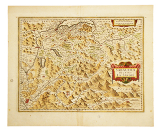
|
|
|
 Recevoir par e-mail
 Télécharger en PDF
 Flux RSS


