|
MARTIN François TOULET Michel
Mémoires en images - BOIS-COLOMBES.
Alain Sutton, 1996, un volume in 8 broché, couverture illustrée, 127 pages, carte et très nombreuses reproductions de cartes postales anciennes légendées. Très bon état.
Référence libraire : 6845
|
|
|
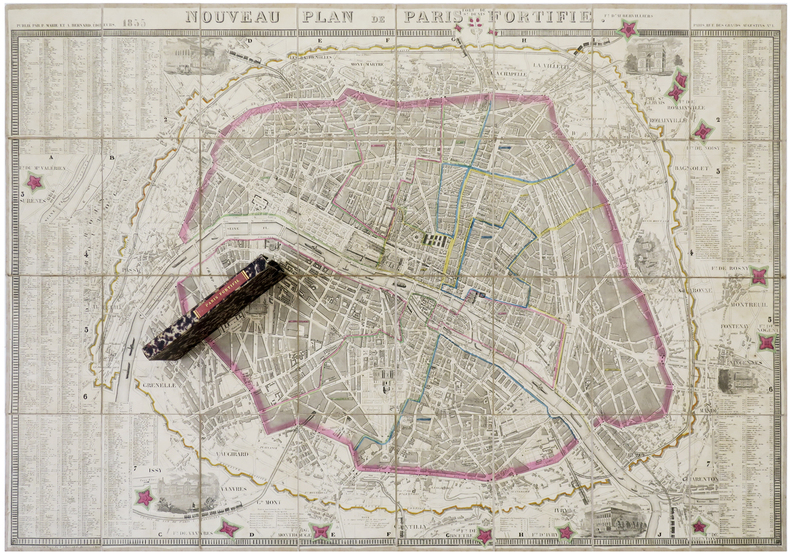
MARIE (P.) & BERNARD (A.).
Nouveau plan de Paris fortifié.
Paris, P. Marie et A. Bernard, 1855. En 32 sections montées sur toile et pliées, formant un plan de 610 x 888 mm ; sous étui de papier marbré avec titre en lettres dorées au dos.
Référence libraire : LBW-6276
|
|
|
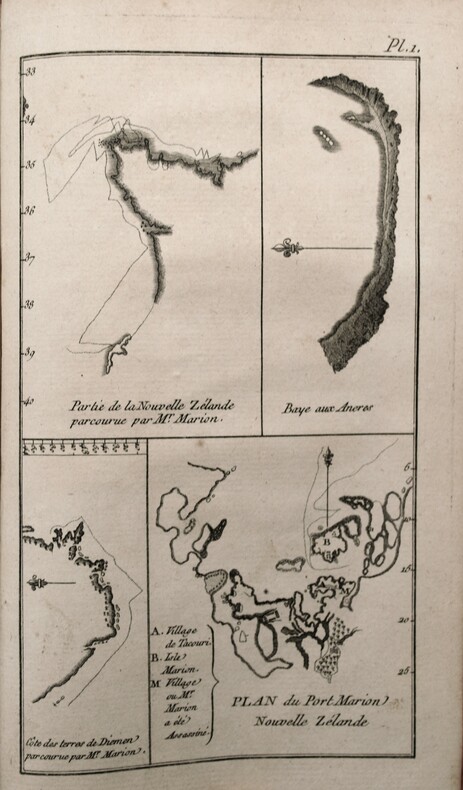
MARION DU FRESNE , CROZET (Julien) , ROCHON (Abbé Alexis-Marie de, rédacteur).
Nouveau voyage à la mer du sud commencé sous les ordres de M. MARION, chevalier de l'Ordre Royal & militaire de S. Louis, capitaine de brûlot ; & achevé, après la mort de cet Officier, sous ceux de M. le Chevalier Duclesmeur, garde de la Marine. Cette relation a été rédigée d'après les Plans & Journaux de M. CROZET. On a joint à ce voyage un Extrait de celui de M. De Surville dans les mêmes Parages.
A Paris, Chez Barrois l'aîné, 1783. In 8° ( 195x120) Relié plein veau époque, pièce de titre rouge, dos lisse orné , tranches rouges . VIII, 290 pp, illustré de 2 cartes dont 1 repliée h.-t. et 5 pl. h.-t. , Complet du dernier feuillet, extrait du privilège à la date du 11 mai 1782, établi par Condorcet secrétaire de l'Académie des sciences.
Référence libraire : PHO-455
|
|
|
MARY DOVE
Numérologie votre avenir par les chiffres.
Collection Guides Pratiques Total, Suivez le Guide Sogemo, 1989, 157 pages, in 12 broché, bon état.
Référence libraire : 11911
|
|
|
Martignon Guy
Quartiers et Rues de Villemomble
SIDES6 La lampe de Mémoire In-8°, broché, 172 pages, gravures, photographies et cartes postales dans un crédit exhaustif : ensemble à l'état de neuf.
Référence libraire : 10072
|
|
|
MARKALE JEAN
Rennes le chateau et l'énigme de l'or maudit.
2006 France loisirs 2006, 318 pages, bon état, in 8 reliure cartonnée noire avec jaquette illustrée en état d'usage (upetites usures et 1 coupure en haut réparée).
Référence libraire : 15603
|
|
|
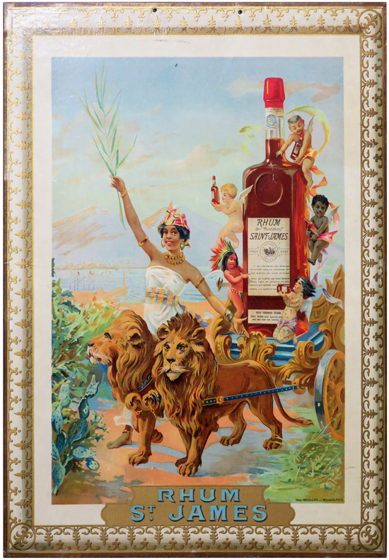
MARTINIQUE.
Rhum St James.
Marseille-Paris, Imprimerie Moullot, [vers 1895]. Chromolithographie originale montée sur carton (70 x 53,5 cm).
Référence libraire : LBW-6785
|
|
|
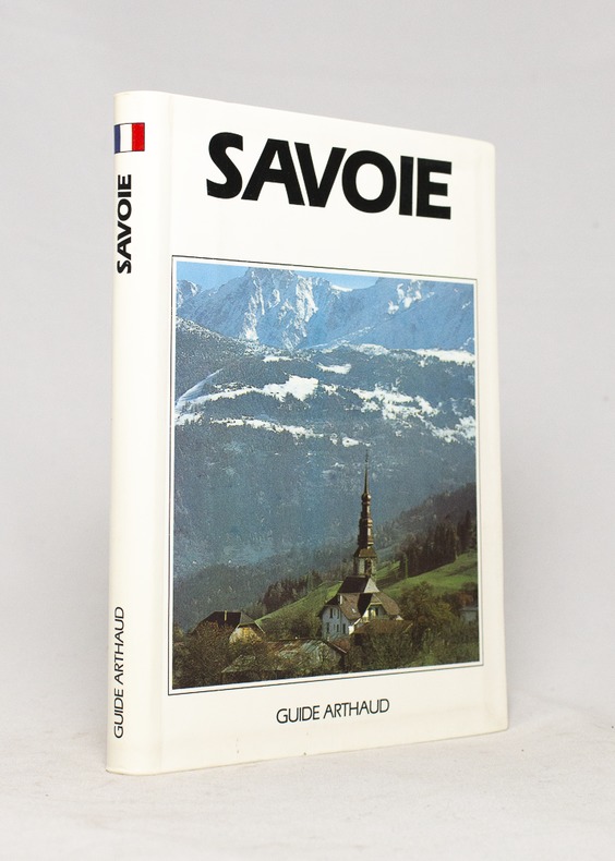
MARIOTTE Ruth et Jean-Yves:
Savoie.
Paris, Les éditions Arthaud, 1991. In-12 de 278-[4] pages, couverture photographique imprimée en couleurs.
Référence libraire : 16664
|
|
|
Marcel (Professeur)
Tous me tours dévoilés nouveaux tours de cartes et physique amusante expliqués pour rire en société
1753 Marcel lemoine (studio physico) 175 rue du temple, café de la monnaie Paris 3eme plaquette In8 22 pages
Référence libraire : 5928

|
|
|
MARIOTTE-LÖBER Ruth
Ville et Seigneurie. Les chartes de franchises des comtes de Savoie. Fin XIIe siècle-1343
Annecy Académie Florimontane 1973 In-8 de 266 pages, couverture imprimée en noir. Couverture usée, traces de griffures.
Référence libraire : 16813
|
|
|
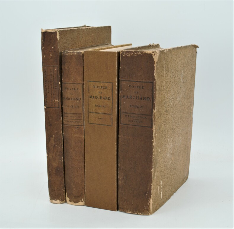
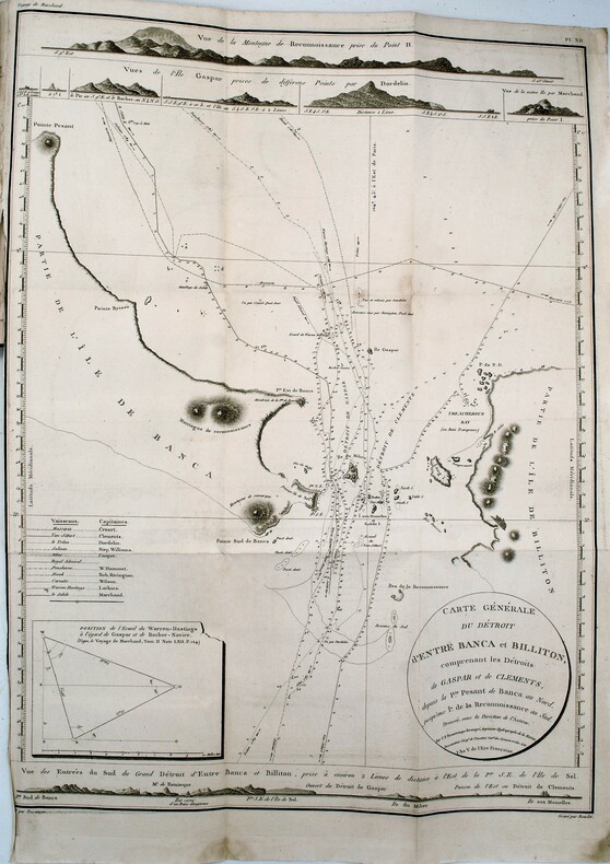
MARCHAND (Étienne) ,FLEURIEU (Charles-Pierre Claret de)
Voyage autour du monde, pendant les années 1790, 1791, et 1792, précédé d’une introduction historique ; auquel on a joint des recherches sur les terres australes de Drake, et un examen critique du voyage de Roggeween.
Paris, De l’Imprimerie de la République, An VI-An VIII [1798-1800]. In-4 (28x22 pour les T.I et II,31,5x24 pour le T .IV) ,xii, cxliv, 628, [3] ; xvi, 676, [2] ;[xi], 431, [1];[2],viii, 158pp, relié couverture d’attente éditeur en cartonnage beige chiné , non rogné , le tome IV n’étant pas ouvert ,défauts d’usage , papier à grandes marges et bruni aux bords ,mouillures au tome III , quelques rousseurs ,tome II reliure demi cuir sous emboîtage à l’identique.Tome I,III et IV premier tirage , Tome II ,1841, ,édition originale remise en vente en 1841 avec un titre de relai portant la mention fictive , "nouvelle édition"(quelques exemplaire imprimés en 1798 n'avaient pas trouver preneur) .L’illustration comprend 16 planches dépliantes gravées sur cuivre, numérotées de I à XV, dont une planche notée VI bis, toutes réunies dans le 4éme tome . Les 15 cartes gravées par Bouclet, Collin, Tardieu, Fortier, etc., levées pour les côtes nord-ouest de l’Amérique du Nord, les îles des Marquesas de Mendoça (îles Marquises), les îles Tupaya (dans l’actuelle Polynésie française), la baie de Tchinkîtâné (actuelle Sitka Sound, près de la ville de Sitka en Alaska), les îles de la Reine-Charlotte (archipel canadien au large de la Colombie-Britannique), les îles Sandwich (Hawaï), le détroit de Magellan, le détroit entre les îles Banca et Billiton (actuelle Belitung) en Indonésie, etc., et une jolie planche à caractère ethnographique (n°V) représentant des échasses de Whûtahô, une des îles de l’archipel des Marquises. Le tome I renferme un tableau dépliant donnant les concordances de mots français avec la langue de Wahîtahô et le tome IV les Observations sur la division hydrographique du Globe .
Référence libraire : PHO-657
|
|
|
MARCHAND (Étienne) – FLEURIEU (Charles-Pierre, Claret de), rédacteur
Voyage autour du monde, pendant les années 1790, 1791, et 1792, précédé d'une introduction historique, auquel on a joint des recherches sur les terres australes de Drake, et un examen critique du voyage de Roggeween ... par C. P. Claret Fleurieu
Deuxième reliure de la première édition. Édition originale in-4 sur grand papier, remise en circulation en 1841 avec un nouveau titre avec la mention fictive "nouvelle édition" (quelques exemplaires imprimés en 1798 n'avaient toujours pas trouvé preneur). Une édition octavo en six volumes a également été publiée. in-4 ,y compris l'atlas. Avec 16 (10 dépliantes) dont 15 cartes gravées, 1 planche gravée et table dépliante. - Beau demi-cuir contemp , dos lisse avec titre et tomaison , petits manques au dos , quelques mouillures intermittentes et vieille trace d’humidité (T1), déchirure carte hydrographique sans manque. xii, cxliv, 628, [3] ; xvi, 676, [2] ;[xi], 431, [1];[2],viii, 158pp.
Référence libraire : PHO-1092
|
|
|
Marco Polo
Gran Canaria Marco Polo Pocket Guide (Marco Polo Travel Guides)
Book in as new unread condition. 140pp. Travel guide to Gran Canaria with road atlas and pull-out map. Map looks unused.
|
|
|
MARCUCCI Giacomo (Attivo a Roma tra il 1620 e il 1640 circa)
Roma
Opera per la prima volta pubblicata nel rarissimo "Giardino del Mondo dove si vede sculpite le citta principale ditalia con le eccelse fabriche antiche e chiese palazzi guglie colonne giardini e fonatene et archi trionfali di Roma" stampato a Roma [s.d. ma circa 1625-30].Si tratta di di un volume "di piccolo formato e privo di indice, è dedicato a Federico Cesi, dondatore dell'Accademia dei Lincei, morto nel 1630. Nella dedica, che compare dopoil titolo figurato, l'autore descrive i motivi che lo hanno spinto ad allestire l'opera" (cfr. Bellucci-Valerio, Piante e vedute di Napoli dal 1600 al 1699, p. 76).Le opere, di piccolo formato, sono una derivazione di quelle di Francesco Valegio contenute in "Descrizione La Raccolta di le piu illustri et famose citta di tutto il mondo" della fine del '500.I rami del Marcucci confluirono nella più celebre tipografia De Rossi, e ristampate nella "Raccolta delle principali città d’Italia intagliate con tutte le contrade, e palazzi di esse" edita a Roma nel 1643 da Giovambattista de Rossi. Una successiva ristampa della stessa è nota a cura di Carlo Losi nel 1773. La pianta, molto rara, viene per la prima volta descritta da Scaccia Scarafoni, che erroneamente ne fornisce l'errata datazione del 1547. Marigliani, nel datarla erroneamente al 1595 circa, ne fornisce la prima accurata descrizione: "è una copia della pianta di Valegio realizzata nell'ultimo decennio del '500 con lievissime differenze solo nella raffigurazione di San Pietro, di cui si vedono le cupole laterali, Santa Maria Maggiore ed il Colosseo più correttamente raffigurato con una parte dell'emiciclo esterno mancante"(cfr. Marigliani p. 164).Incisione in rame, in perfette condizioni. Rarissima. Bibliografia Scaccia Scarafoni (1939): n. 132; Frutaz (1960) n. 139 (nota); Marigliani (2007): p. 164, n. 65. A small and very rare map of Rome, for the first time published in the very rare "Giardino del Mondo dove si vede sculpite le citta principale ditalia con le eccelse fabriche antiche e chiese palazzi guglie colonne giardini e fonatene et archi trionfali di Roma" printed in Rome [s.d. but about 1625-30]. It is a volume of small format and without index, dedicated to Federico Cesi, founder of the Accademia dei Lincei, who died in 1630. In the dedication, which appears after the illustrated title, the author describes the reasons that pushed to prepare the work (see Bellucci-Valerio, Piante e vedute di Napoli dal 1600 al 1699, p. 76). The small-sized works are a derivation of those by Francesco Valegio contained in "Descrizione La Raccolta di le piu illustri et famose citta di tutto il mondo" from the end of the 16th century. Marcucci's platess flowed into the most famous De Rossi typography, and reprinted in the "Raccolta delle principali città d’Italia intagliate con tutte le contrade, e palazzi di esse" published in Rome in 1643 by Giovambattista de Rossi. A subsequent reprint of the same is known by Carlo Losi in 1773. The very rare map is described for the first time by Scaccia Scarafoni, who erroneously gives the wrong date of 1547. Marigliani, erroneously dating it to about 1595, provides the first accurate description: "it is a copy of the map of Valegio built in the last decade of the 16th century with very slight differences only in the depiction of St. Peter, of which you can see the side domes, Santa Maria Maggiore and the Colosseum more correctly depicted with a part of the external hemicycle missing "(see Marigliani p . 164). Copper engraving, in perfect condition. Extremely rare. Bibliografia Scaccia Scarafoni (1939): n. 132; Frutaz (1960) n. 139 (nota); Marigliani (2007): p. 164, n. 65.

|
|
|
Mardesic, S. - Segal, J. (editors)
Shape Theory: the Inverse System Approach (North-Holland Mathematical Library)
Mm 150x225 Volume in copertina rigida originale, xv-378 pagine. Copia ottima, spedizione in 24 ore dalla conferma dell'ordine.
|
|
|
Margaret Cousins; Illustrator Photographs and Maps
STORY OF THOMAS ALVA EDISON THE Landmark #110
Random House 1965. Hardcover. Good. Disclaimer:A copy that has been read but remains in clean condition. All pages are intact and the cover is intact. The spine may show signs of wear. Pages can include limited notes and highlighting and the copy can include previous owner inscriptions. An ex-library book and may have standard library stamps and/or stickers. The dust jacket is missing. At ThriftBooks our motto is: Read More Spend Less. Random House hardcover
Référence libraire : GB000VBH20OI3N11

|
|
|
Margaret Cousins; Illustrator Photographs and Maps
The Story of Thomas Alva Edison Landmark # 110 HB/PC
Random House 1965. Hardcover. Excellent. Rare Collectible Pictorial Cover Book is in Very Good Plus condition with a tight binding and clean crisp pages. Inside text is in Excellent Condition and is Unread. There is a name written neatly at the top right hand corner of the second end page but no other writing or marks in the book. Outside pictorial covers are nice with some minor soiling and wear to the outside corners and edges. It looks like there was a small piece of tape on the outside spine above the Landmark Shield but this is definitely NOT an ex-library book. Overall a very nice unread and Non Ex-Library copy of this title. Very Hard to Find as a Non-Library Book in this condition! This book was NOT published with a Dust Jacket. Landmark Books Volumes 104-122 are only available in the picture cover format also these titles had virtually no trade sales with public and school libraries taking most of the books. Landmark Books and World Landmark Books are accurate in-depth stories for young people in the 9-15 year old range. These living histories were written by award-winning authors or by men and women who experienced the events first hand. Written during the 1950's and 1960's and illustrated either with two-color drawings or clear photographs the books are informative enjoyable and well worth reading and collecting. The Story of Thomas Alva Edison Landmark Book #110. Here is a colorful account of America's greatest inventor who was also one of American's most rugged individualists. Simply and clearly the author explains Edison's contributions to the electric light the telephone the phonograph the electric locomotive radio broadcasting motion pictures and many other aspects of our modern electrified world. Random House hardcover
Référence libraire : 200620C

|
|
|
Margolin Malcolm INSCRIBED illustrated by Carl Dennis Buell maps by Sharon G. Johnson
THE EAST BAY out a Personal Guide to the East Bay Regional Parks
Berkeley: Heyday Books. Very Good in Very Good dust jacket. 1988. Second Edition. Hardcover. 0930588355 . Inscribed by Margolin on the front fly dated 3/24/88. Heyday Books revised edition c 1988 hardback first thus complete number line green cloth Very Good just a hint of bumping to the lower board corners /Very Good dust jacket price-clipped 227 pages. A very nice copy. ; F5106 F2f; 8vo 8" - 9" tall; 227 pages; Signed by Authors . Heyday Books hardcover
Référence libraire : 19214 ISBN : 0930588355 9780930588359

|
|
|
Mari Sandoz/Brian Forsyth Illus. and maps
Love Song to the Plains
Harper & Brothers Publishers. Used - Good. 1961 Hardcover First Edition . Shows some signs of wear and may have some markings on the inside. Harper & Brothers Publishers hardcover
Référence libraire : GRP63696126
|
|
|
Marinache V. Maps by
Romania; a Guidebook
Bucharest Meridiane Pub. House 1967. First Edition. An exceptional copy; fine in an equally fine dw. Complete with slightly worn stiff-card slipcase. Particularly and surprisingly well-preserved; tight bright clean and especially sharp-cornered. Literally as new. ; 491 pages; Description: 491 p. Illus. part col. col. Maps. 18 cm. Subjects: Romania --Guidebooks. Bucharest, Meridiane Pub. House unknown
Référence libraire : 88199

|
|
|
Marjatta Bell; Marjatta Hietala
Helsinki, the Innovative City
No marks or inscriptions. No creasing to covers or to spine. A lovely clean very tight copy with bright unmarked boards and no bumping to corners. Dust jacket not price clipped or marked or torn or creased with very minor traces of storage 447pp. History, culture, development and the society of Helsinki, Finland's Capital City. 'Helsinki - The Innovative City' describes how the capital of Finland was developed into a handsome, sophisticated city. It tells the story of how its innovative citizens and its determined City Council turned a small rocky seaport into a European city of distinction with fine public services and continuing links with the surrounding nature.
|
|
|
Mark A.; star maps by Wil Tirion Garlick
The Illustrated Atlas of the Universe
2006-07-04. New. Ships with Tracking Number! INTERNATIONAL WORLDWIDE Shipping available. May be re-issue. Buy with confidence excellent customer service! unknown
Référence libraire : 1740893778n ISBN : 1740893778 9781740893770

|
|
|
Mark A.; star maps by Wil Tirion Garlick
The Illustrated Atlas of the Universe
2006-07-04. Good. Ships with Tracking Number! INTERNATIONAL WORLDWIDE Shipping available. May not contain Access Codes or Supplements. May be re-issue. May be ex-library. Shipping & Handling by region. Buy with confidence excellent customer service! unknown
Référence libraire : 1740893778q ISBN : 1740893778 9781740893770

|
|
|
Mark Brandenburg
Brandenburgum Marchionatus. Cum Ducatibus Pomeraniae et Mekelenburgi. Original-Kupferstich von Matthäus Merian, mit Titelkartusche u. Meilenzeiger.
(Frankfurt a. M.), M. Merian, [ca. 1652]. Mit Mittelfalz. Darstellung: 36 x 27,5 cm; Blatt: 39,5 x 34 cm. Gerahmt. Unter braunem Passepartout.
Référence libraire : 86713

|
|
|
Markidou, Loula and Caudery, Tim
Cyprus : A Comprehensive Guidebook
No marks or inscriptions. No creasing to covers, light crease down spine. A clean crisp very tight copy with bright covers and no bumping to corners. 113pp. The culture and history of the island in a gazetteer style, with superb colour photographs.

|
|
|
Markus Hauser/ Gecko Maps
Tajikistan Northern
Swiss Cooperation Office Tajikistan 2009. Map. New. 1st edition. 2 pages. 7.00x4.10x0.40 inches. Swiss Cooperation Office Tajikistan unknown
Référence libraire : __3906593452 ISBN : 3906593452 9783906593456
|
|
|
MAROC. . .
Carte en couleurs extraite de l'Atlas Universel. Sans date.
1 feuille 50x40 cm. Pli central.
|
|
|
Marr DSB./Howick Baker JD. maps/Bromet Geoffrey R. foreword D. S. J. D.
A History of 208 Squadron
Southend on Sea: Eden Fisher Ltd. printed by 1966. 1st printing. VG. vi 115 p. photos maps appendices large 8vo paperback; Eden Fisher Ltd. (printed by) paperback
Référence libraire : 51524

|
|
|
MARRES Paul , BLANQUET Léon
L'HERAULT Géographique & Historique : Choix De Lectures . Complet De ses Pages Dépliantes En Fin D'ouvrage
Ancien livre d'école avec son dos en percaline . Complet de sa carte géologique dépliante et de ses cartes : historique et tableaux chronologiques . Illustré de photographies en noir et blanc . Cartes et plans . Régionalisme Languedoc . - 284 p. , 400 gr.

|
|
|
MARSEILLE- CARPENTRAS
Carte touristique au 1/100 000e.
Une feuille 89x121 cm.
|
|
|
Marshall SLA./Lennox Mark maps S. L.
Crimsoned Prairie: The Wars Between the United States and the Plains Indians During the Winning of the West
NY: Charles Scribner's Sons 1972. 1st printing. VG/VG dust jacket very light bumping to top corners price clipped dust jacket. xviii 256 p. photos maps index 8vo; Charles Scribner's Sons hardcover
Référence libraire : 72308 ISBN : 0684130890 9780684130897

|
|
|
Marshall, General.
GENERAL MARSHALL'S REPORT. The Winning of the War in Europe and the Pacific. Biennial Report of the Chief of Staff of the United states Army July 1, 1943 to June 30, 1945, to the Secretary of War.
123p. Illustrated with numerous maps. Large 4to. Original printed wraps, damp stained. WORLD WAR II BOX 4
|
|
|
Marshall, James Stirrat; Marshall, Carrie
Adventure in Two Hemispheres - Including Captain Vancouver's Voyage
208 pages including index and black and white illustrations. "From much accumulated data we have woven a non-fiction historical book which it is hoped will fill a practical need in the literature of the Pacific Coast and the Hawaiian Islands, and may interest readers in Canada, the United States, Hawaii and Great Britain... Extracts of Vancouver's original 1798 charts were photographed and are included, while in some instances these are compared with modern maps." - from foreward. Decorated front board. Average wear. Binding intact. Solid copy. Book
|
|
|
Martin David G.; research by Irene F. Brummerstedt; maps by John Helper
Carl Bornemann's Regiment The Forty-First New York Infantry DeKalb Regt. in the Civil War
Hightstown NJ:: Long street House 1987. First Edition. Hardcover. Limited edition one of 500 copies. Octavo about 8.75 inches 22 cm tall in gilt stamped blue cloth. 323 pages illustrated by maps drawings some photo portraits including a frontis. Dornbusch vol. IV #4532. A history of an all-German volunteer unit. The book is bright clean sound and unworn. The jacket is complete and without tears but the spine is noticeably sun faded. Long street House, hardcover
Référence libraire : 17640
|
|
|
Martin David/Dolling Sve maps
The Web of Disinformation: Churchill's Yugoslav Blunder
San Diego: Harcourt Brace Jovanovich 1990. 1st printing. Fine/Fine dust jacket. xxxvi 427 p. maps biblio notes appendices index 8vo; Harcourt Brace Jovanovich hardcover
Référence libraire : 71371 ISBN : 0151807043 9780151807048

|
|
|
Martin George RR. novel; Howe John illustrations; Keegan Charles sigils & maps R. R.
A Clash of Kings - Signed Limited Edition
<p>Meisha Merlin Publishing Inc. Atlanta GA 2003. First Edition Thus. One of 448 numbered copies signed by the author illustrator and cartographer. Thick octavo 23.5cm; maroon cloth with titles stamped in gilt on spine; top edge gilt; dustjacket; publisher's gilt-stamped maroon cloth slipcase. Fine in a Fine dustjacket and slipcase. The second volume in Martin's critically acclaimed 'A Song of Ice and Fire' series and the last of the exquisite volumes in the series produced by now-defunct publisher Meisha Merlin. We also have the matching number set by Subterranean Press in a separate listing.</p> Meisha Merlin hardcover
Référence libraire : biblio565 ISBN : 1892065312 9781892065315

|
|
|
Martin Illustrated by Maps and Photographs Gilbert
The Holocaust: A Record of the Destruction of Jewish Life in Europe During the D.
The Jerusalem Post 1978 Jerusalem 1978. First Edition. Paperback. Very Good. b/w Illustration. 8vo - over 7�" - 9�" In pictorial wraps 8vo 60pp. Illustrated. minor light shelfwear to extremities. The Jerusalem Post, 1978, Jerusalem paperback
Référence libraire : 0824724 ISBN : 0905648056 9780905648057

|
|
|
Martres, Laurent
Photographing the Soutwest : Volume 1 - A Guide to the Natural Landmarks of Southern Utah
No marks or inscriptions. No creasing to covers or to spine. A very clean very tight copy with bright unmarked boards and no bumping to corners. 320pp. A travel guide to the natural landmarks of Southern Utah including Grand Circle, Red Rock Country and Dinosaur National Monument with emphasis on the opportunities for spectacular photography and with over 240 full-color photographs.
|
|
|
Mary March MA. Jenny Lona PhD Alti Editor Elibeth Haidle Illustrator Paul Haidle Illustrator Maps by National Geographic I
Instant Immersion Ingles Manual Edicion Superior Spanish Edition
Topics Entertainment 2008-05-01. 2nd. Paperback. Used:Good. Topics Entertainment paperback
Référence libraire : DADAX1600774032 ISBN : 1600774032 9781600774034
|
|
|
Mary March; MA.; Jenny Lona PhD; Editor Alti; Illustrator Elibeth Haidle; Illustrator Paul Haidle; Illustrator Maps by National
Instant Immersion Ingles Manual Edicion Superior Spanish Edition
Topics Entertainment 2008-05-01. Paperback. Good. Topics Entertainment paperback
Référence libraire : SONG1600774032 ISBN : 1600774032 9781600774034
|
|
|
Mary Pedley on land company mapping in North America Catherine Delano Smith on maps in 16th c. bibles Susan Gone; others
Imago Mundi The Journal of the International Society for the History of Cartography Volume 42
Imago Mundi Ltd. London. Collectible - Very Good. Very good book. Volume 42. Maps illustrations. Inquire if you need further information. Imago Mundi, Ltd., London unknown
Référence libraire : O06B-00509 ISBN : 0905776143 9780905776149
|
|
|
MaryGrace Dansereau MAPS
Journey to Emmaus
CreateSpace Independent Publishing Platform. Paperback. GOOD. Spine creases wear to binding and pages from reading. May contain limited notes underlining or highlighting that does affect the text. Possible ex library copy that’ll have the markings and stickers associated from the library. Accessories such as CD codes toys may not be included. CreateSpace Independent Publishing Platform paperback
Référence libraire : 3189990123 ISBN : 1530407427 9781530407422
|
|
|
MARZOLLA Benedetto (Brindisi, 1801 - Napoli, 1858)
Impero di Alessandro
Carta storica raffigurante i territori dell'Impero di Alessandro Magno intorno al 323 a.C. Tratta dall’ Atlante geografico. Corredato di notizie relative alla geografia fisica politica, ed in generale alla statistica delle varie regioni del Globo. Compilato ed eseguito in litografia per cura e sotto la direzione di Benedetto Marzolla edito a Napoli nel 1858. Marzolla, autore di importanti atlanti sulle provincie del Regno di Napoli, è anche autore di diverse carte sulle Circoscrizioni Ecclesiastiche nel Regno delle Due Sicilie, pubblicate postume, nello stesso anno della morte (1858) a Napoli nello Stabilimento Geografico diretto da Luigi Manzella. Benedetto Marzolla fu disegnatore topografo e litografo; geografo e cartografo; membro della Commissione di statistica presso il Ministero dell'Interno. Personaggio di grandissimo rilievo nella cartografia napoletana ed italiana del XIX secolo, Marzolla ottenne in vita pubblici riconoscimenti ed attestati per la produzione cartografica di altissima qualità. La sua notorietà si è lentamente dissolta dopo la morte; va tuttavia osservato che solo la mancanza di uno spiccato coinvolgimento politico in senso risorgimentale e di una valenza letteraria nella sua opera non lo hanno reso famoso come i contemporanei Francesco Costantino Marmocchi (1805-1858) e Attilio Zuccagni-Orlandini (1783-1872), con i quali può certamente confrontarsi. I progetti culturali didattici e editoriali di Marzolla furono e rimangono di straordinaria modernità; egli inventò, è il caso di dire, un nuovo modo di intendere e di disegnare la carta geografica, fornendo una visione assolutamente originale della comunicazione dei dati geografici attraverso la combinazione di testo e immagine. Con tale operazione, egli riuscì a fondere in un'unica opera, storia, geografia, economia, statistica e cartografia, raggiungendo un equilibrio grafico di rara efficacia (cfr. V. Valerio, Benedetto Marzolla Brindisino, Geografo e Cartografo dell'800 Europeo, Brindisi 2008). Bell’esemplare con coloritura coeva dei contorni, in ottimo stato di conservazione. Bibliografia V. Valerio, Benedetto Marzolla Brindisino, Geografo e Cartografo dell’800 Europeo (2008). Historical map depicting the territories of Alexander the Great's empire, around 323 BC. Taken from the Atlante geografico. Corredato di notizie relative alla geografia fisica politica, ed in generale alla statistica delle varie regioni del Globo. Compilato ed eseguito in litografia per cura e sotto la direzione di Benedetto Marzolla published in Naples in 1858. Marzolla, author of important atlases on the provinces of the Kingdom of Naples, is also the author of several maps on the Ecclesiastical Circumscriptions in the Kingdom of the Two Sicilies, published posthumously in the same year of his death (1858) in Naples in the Stabilimento Geografico directed by Luigi Manzella. Benedetto Marzolla was draftsman topographer and lithographer, geographer and cartographer. Character of great importance in the Neapolitan and Italian cartography of the nineteenth century, Marzolla obtained during his life public recognition and certificates for the production of high quality cartography. His notoriety slowly faded after his death; it should be noted, however, that only the lack of a strong political involvement in the sense of the Risorgimento and of a literary value in his work did not make him as famous as his contemporaries Francesco Costantino Marmocchi (1805-1858) and Attilio Zuccagni-Orlandini (1783-1872), with whom he can certainly compare himself. Marzolla's cultural, didactic and editorial projects were, and remain, extraordinarily modern; he invented a new way of understanding and drawing maps, providing an absolutely original vision of the communication of geographical data through the combination of text and image. With this operation, he was able to merge in a single work, history, geography, economics, statistics and cartography, achieving a graphic balance of rare effectiveness. Benedetto Marzolla is famous for being among the most important cartographers of the XIX century, for being the one to print geographic maps using high quality lithographies.His Atlante Geografico, made of 58 maps, presents finely sketched works. Six maps depict North America, among them famous map of gold diggers in California, deriving from Hippolite Ferry. Extremely relevant are also the maps of Antarctic, South Africa with the plan of Cape Town and those about Australia.Though the maps are dated between 1843 and 1856, this 1858 edition, printed in Naples at the Stabilimento Geografico Strada San Carlo (founded by Marzolla himself), represents the final version of his atlas, the last one before his death. A posthumous edition will be published in 1865.The atlas is pretty rare, is not actually listed in Phillips, British Library e OCLC. Beautiful specimen with contemporary coloring of the contours, in excellent condition. Bibliografia V. Valerio, Benedetto Marzolla Brindisino, Geografo e Cartografo dell’800 Europeo (2008).

|
|
|
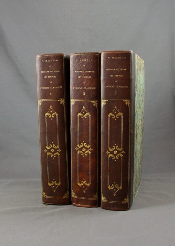
MASPERO G:
Histoire ancienne des peuples de l’Orient classique.
Paris, Lib. Hachette, 1895-1899. 3 vol. in-4 de 804 + 798 + 826 pp. demi-maroquin noir, dos lisse orné de fers d’inspiration romantiques, couv. d’origine cons. Bel état.
Référence libraire : 1570
|
|
|
MASSIP Catherine - Emmanuel Le Roy Ladurie (préface) - Avec la participation des Départements ds Cartes et Plans, des Estampes, des Livres imprimés, des Manuscrits occidentaux et orientaux, des Médailles, et de la Musique de la Bibliothèque Nationale
Le chant d'Euterpe, l'aventure de la musique
1991 Hervas, collection Banque Nationale de Paris - 1991 - In-4 couverture cartonnée noire décorée - 188 pages - nombreuses reproductions photographiques
Référence libraire : 98357
|
|
|
MASCARON JULES
Recueil des oraisons funèbres .
1740 Jean Desaint 1740 reliure cuir dos à 5 nerfs titres et décors or , bords des plats et coiffes légèrements usés intérieur très frais 429 pages .
Référence libraire : 6304
|
|
|
Maslow Jonathan/Thompson Victor maps
Footsteps in the Jungle: Adventures in the Scientific Exploration of the American Tropics
Chicago: Ivan R. Dee 1996. 1st printing. Fine/Fine dust jacket. x 309 p. photos maps biblio index 8vo; Ivan R. Dee hardcover
Référence libraire : 21102 ISBN : 1566631378 9781566631372

|
|
|
Massachusetts Bay Colony Tercentenary Commission; Illustrated by Period photos drawings maps Illustrator
Massachusetts on the Sea 1630-1930
Mass. Bay Colony Ter Com 1930-01-01. Hardcover. Good. 1930 hardback no marks and is in good condition cover shows wearAND AS ALWAYS SHIPPED IN 24 HOURS; and emailed to you a USPS tracking number on all orders; all books are sanitized and cleaned for your protection before mailing Mass. Bay Colony Ter, Com hardcover
Référence libraire : 130125011
|
|
|
Masters Journal 1992 McDermott John R. Ed; Glossy Color Photos MAPS Illustrator
Masters Journal 1992
Events Pub; Golf Digest 1992-01-01. Unknown Binding. Like New. Appears unused with no marks or inscriptions. Light general shelf wear. Events Pub; Golf Digest unknown
Référence libraire : 004105
|
|
|
Matvejevitch Predrag
Bréviaire méditerranéen
Fayard 1992 In-8 broché 23 cm sur 15. 264 pages. Très bon état d’occasion.
Référence libraire : 107863
|
|
 Recevoir par e-mail
 Télécharger en PDF
 Flux RSS


