|
MUENSTER SEBASTIAN
Der Statt Meyland gestalt/anfang/und wie sie zugenommen hab.
200,00
|
|
|
MUENSTER SEBASTIAN
Die Siebenbuerg so man sunst auch Transsylvaniam nenne.
260,00
|
|
|
Muir Peter; maps by Frances Muir
This Is India
Doubleday Doran & Co 1943. Stated first edition. Hardcover. near fine /good. NOT an ex library book. Clean interior pages. Dust jacket has 1" chip top rear by endflap 1/4" chips and tears price is not clipped. Doubleday, Doran & Co hardcover
Référence libraire : 309494
|
|
|
MULHAUSEN
Carte allemande au 1/80 000?. Fin XIXe.
1 feuille repli?e. 31,5x45 cm.
|
|
|
MULHOUSE
Carte d'Etat-Major au 1/320 000?, lev?e en 1854.
1 feuille repli?e. 63x90 cm.
|
|
|
MULHOUSE
Carte d'Etat-Major au 1/80 000?, lev?e en 1837.
1 feuille repli?e. 63x90 cm.
|
|
|
Muller (Hrsg.)
Le Royaume de Boheme, le Duche de Silesie et les de Moravie et Lusace. Presses d'apres les Cartes de Muller, par le Sr. Robert. Grenzkolorierte Kupferstichkarte.
Venise, P. Santini chez M. Remondini 1777. Kartengröße: 55x48,5 cm; Blattgröße:76x53,2 cm; rechts oben dekorative Titelkartusche, li. oben Maßstabsskala, kolorierte Randleiste, Mittelalz leicht gebräunt und unten über die Randleiste eingerissen, rundum Randrisse im weißen Rand. Die Karte zeigt das Gebiet Böhmens, Tschechiens, Schlesiens etc.
Référence libraire : KART0153

|
|
|
MULLER.
Neueste Post Karte von ganz Deutschland… Nouvelle Carte des Postes d'Allemagne, de France, Hollande, Prusse , Pologne, Hongrie, Italie, Suisse.
1806 toilée. carte , 65 x 102 , Vienne Artaria et cie , 1806,
Référence libraire : 11799
|
|
|
MULLIE C.
Fastes de la France ou tableaux chronologiques, synchroniques et géographiques de l’histoire de France depuis l’établissement des Francs jusqu’à nos jours.
Indiquant les politiques,les progrès des de la civilisation et les hommes célèbres de chaque règne.Cinquième édition entièrement refondue.Grand in folio demi-cuir,titre,fers dorés en long.Faux-titre,titre,212p. (texte ainsi que page de titre encadrés d’une frise décorative,Gaulois et le Franks,siècle de Charlemagne,d’Alfred le grand,de Hugues Capet,de Guillaume le Conquérant,Philippe Auguste,de Gengis Khan,etc… 8 cartes sur double page montées sur onglets.d’après MM. Carette et Renon 1845(la dernières carte est celle de l’Algérie) rousseurs habituelles quelques petites déchirures en marge réparées.Cuir cassant avec quelques petites restaurations d’usage.Paris-Poignavant 1845
Référence libraire : 547
|
|
|
MULLIE C. Cartes hors-texte.
Fastes de la France. Ou tableaux chronologiques, synchroniques et géographiques de l'histoire de France, depuis l'établissement des Francs jusqu'à nos jours.
Couverture rigide. Reliure demi-basane défraîchie, légèrement cintrée. 212 pages. 29 x 44 cm. Rousseurs.
Référence libraire : 46806
|
|
|
Mullin, Tom [Ed.]
The Nature of Chaos
Oxford : Clarendon Press 1995. XXII, 314 S. (23,5 cm) Broschierte Ausgabe
Référence libraire : 50867 ISBN : 198539541
|
|
|
Mullin, Tom [Ed.]
The Nature of Chaos
Oxford : Clarendon Press 1993. XXII, 314 S. (23,5 cm) Broschierte Ausgabe
Référence libraire : 50884 ISBN : 198539541
|
|
|
Mulltiple Contributors
Frontier Times Magazine: May 1973
Features: Are the Peralta Stone Maps a Hoax?; Old Betsy - queen of the Kansas Southern and Gulf Railroad; The West Wind Blows - stagecoach loot cached on the Conejos; The Man who put Nebraska in the shade - more than one million trees planted on 10 April, 1872 - the beginning of Arbor Day; Too much gold talk will get you killed - 40 wagons rolled through West Texas from the goldfields of California; The grave on the hill west of Laramie - Clement S. Bengough; Blue - a family's horse; Northern Minnesota's Gold Rush - a state geologist who falsely claimed that in 1865 he had found high-grade ore near Lake Vermillion unknowingly influenced the outcome of World War I!; Bare fist fighter James 'Yankee' Sullivan; Frontier foods and cookery; and more. Clean, bright and unmarked with very light wear. Nice copy. Magazine

|
|
|
Multiple Contributors
Canadian Antiques Collector - May 1969, Vol. 4, No. 5 - Globes
Features: Decorating with Antiques; Maps in the Round - Globes; Brighton Pavillion; Early Steamships on Lake Ontario; Maria Morris - Early Nova Scotia Artist; Scotland's Architectural Heritage. Average wear. Sound copy. Book

|
|
|
Multiple Contributors
Canadian Antiques Collector Magazine, June 1967, Volume 2, Number 6
30 pages. Features: Papineau House - Old Montreal Reborn; London Letter - Kremlin has largest collection of Tudor and Stuart Plate; Port Hope Pottery, by Kathleen M. Graham Stearns; Antique Safari - Maritimes Adventure, by Ann Newton; Collecting Maps, by Alexander E. Macdonald, M.D.; A Timeless Season - Roloff Beny in Canada; Musee Historique de Vaudreuil Soulanges. Bit of writing atop front cover. Average wear. A sound copy. Book

|
|
|
Multiple Contributors
Canadian Aviation Magazine, July 1948
82 pages. Features: Ground Control Approach Radar for the RCAF; Pilot Error; Navigating from the Cockpit; Wings of Britain; Turbine Era is the Target; Gloom, Excitement in Jet Program; British Seek Transport Lead; Supersonic Fighters for British Arsenal; Aim to Reduce Lightplane Costs; Flight Simulator Trains Crews; Ottawa Report; Canadian Accident Analysis; Maintenance Section; Curved Maps for Navigation; and more. Many pages of great ads including the de Havilland Beaver. Small ink stamp atop front cover. Front cover partially loose. Average wear. Binding intact. A worthy vintage copy. Magazine

|
|
|
Multiple Contributors
Canadian Collector Magazine, January/February 1976, Vol. 11 No. 1 *SPECIAL ALBERTA ISSUE*
Features: Prehistoric Plainsmen; Fort Chipewyan; Saint Albert; Writing on Stone - Milk River Valley; The Ranching Saga of Southern Alberta; Home, House and Temple Among the Plains Indians; Oil City, Alberta; Some Early Travellers' Accounts of Alberta; The Mountains in Maps; The Frontier Art of R.B. Nevitt; Gerald Tailfeathers; Carl Rungius - An Artist's View of Nature; Architectural Heritage; Heritage Park; Ukrainian Vernacular Architecture; Medalta Pottery; Saddles; Hutterites - The Peaceful People; Cattle Brands; From an Alberta Kitchen; Beadwork by Alberta Native Peoples; The Doukhobors; Museums in Alberta; and more. Average wear. Date hand-written atop front cover. Sound copy. Magazine

|
|
|
Multiple Contributors
Equinox - The Magazine of Canadian Discovery: June/July 1999
Features: In this Eternal Land - Canadians shed new light on Egypt's fascinating past; Voices on the River - Heeding the call of the Ganges River dolphins; Maps and Memories - it took three centuries for Europeans to make their way across Canada... it is a country that is remarkably savage in nature and character; Sonoran North - three desert species move into Alberta's badlands and find themselves perfectly at home. Light wear. Quality copy. Book

|
|
|
Multiple Contributors
Happy Motoring, Volume 19, Number 5 - an Imperial Oil/Esso Periodical
Features: Up and down the Laurentians; the dramatic Deas Island Tunnel - article with great photos; Through the Annapolis Valley; Take your children to Storybook Gardens, a project of the London Public Utilities Commission (PUC); History with a high fence - Fort Macleod has captured much of southern Alberta's history and put a stockade around it; Time for all - public clocks in Canada; Imperial has already printed 25 million road maps!. Illustrated with black and white photos. Average wear. A sound copy of this vintage issue. Book

|
|
|
Multiple Contributors
Happy Motoring: A Publication of Esso/Imperial Oil, Volume 16, Number 1, 1955 - New Roads to Atikokan and Steeprock Mine
Features: Highway to Canoe Country - one of Ontario's newest roads leads to the well-established town of Atikokan and Steeprock Mine in Northwestern Ontario; Five Ways to 'Do' the Rockies; The Woodcarvers of Port Joli - Route 2 on the south shore of the St. Lawrence; Twin Brothers, Twin Trucks - The Robertson brothers, Dave and Phil, from near Niagara Falls and their 1948 1/2-ton pickup trucks customized with early truck caps for storage and sleeping, all for less than $50.00!; Those Road Maps, by Lillian Allison. Two-inch opening at bottom of cover fold. Average wear. Unmarked. A sound copy. Book

|
|
|
Multiple Contributors
Maclean's Magazine, March 1, 1954 - First Hand Report on Rudolf Hess
64 pages. Features: Nice colour RCAF ad inside front cover; Dispute Still Surrounds Duff Cooper; More Canadians than Jobs; Lovely colour full-page ad for 1954 DeSoto automobiles; The Seven Living Ghosts of Nuremberg - an uncensored first-hand report from behind the bars of Spandau where Rudolf Hess, Karl Doenitz, Baldur Von Schirach, Walther Funk, Erich Raeder, Albert Speer and Baron Konstantin Von Neurath - top Nazis - imprisoned for crimes against humanity wait out the tortuous years while the world forgets they exist - with photos; Athabaska's Atom Boom - Albert Zeemel's discovery of Uranium sparks the development of Uranium City, Saskatchewan - great article with many photos; The Maps that Charted our History - a famous collection, published here for the first time, show the slow evolution of Europe's knowledge about Canada; How Early Map Makers Saw the Great Lakes; The Brainiest School in the Country - Dalhousie Law School - article with photos; How Papa Masella Made His Boys Make Music - Frank Masella of Montreal and his eight musical sons; In the Lost World of the Cypress Hills - this strange mountain on the prairies harbors tropical scorpions, petrified figs, fourteen kinds of orchid and a lawless past that sparked the formation of the Mounties; Are People Monkees? - fiction by James McNamee; Ford colour V-8 ad; 1954 Plymouth ad; Colour Buick ad; Chevrolet truck ad; and more. Average wear. Couple of small chips from covers. Unmarked. A quality copy. Book

|
|
|
Multiple Contributors
Scientific American, December 1982 - Radar Images of the Earth
180 pages. Features: Migration between the core and the periphery; radar images of the earth from space; the development of maps and stripes in the brain; personal computers; samples of the Milky Way; the interaction of moving water and sessile organisms; the search for prime numbers; the lamps of Cosa; and more. Bit of writing to front cover and page 3. Covers partially detached from staples. Many nostalgic color photo ads, including an early Microsoft ad which incorporates their early green logo. Moderate wear. A quality copy. Magazine

|
|
|
Multiple Contributors
The Antique Collector Magazine, April 1969 / May 1969
Features: Antiques and Television; Oak House, West Bromwich, Staffs - a Tudor Yeoman's House which has survived an Industrial Tide; Decorative Early Maps; The Hannah Gubbay Collection; "Chayres with Iron Worke" - an account of some late 17th century 'Sleeping' Chairs; The 7th Scottish Antiques Fair; The "AW" Master Salt - a unique example of 17th century English Delftware; The Macabre in Art - as illustrated by Pictures of "The Temptation of St. Anthony"; The Blazing Myth and Kindred Matters for "Silhouette" collectors; Fair news; and more. Few markings. Average wear. Magazine

|
|
|
Multiple Contributors
The Encyclopaedia Japonica: A Dictionary of Commerce
A massive Japanese commercial reference from the early 1900s. Approximately 2,000 pages. Text primarily in Japanese, other than the 18-page bilingual (Japanese/English) index and an intriguing bilingual fold-out sample of various contemporary export documents. Two items laid inside front board include a double-sided bilingual glossary of commonly used trade terms and a wonderful 22" wide by 16" high colour map of the world with trade routes to/from Japan indicated in red. Most text on the map is Japanese with some place names in both English and Japanese. Please note that library name is stamped through the blank upper right corner of the map. Elaborately gilt-decorated backstrip with title in Japanese and English bears considerable wear but is still handsome and, dare we say, mysterious. Per a handwritten inscription inside back board, this copy was presented to representatives of the Seattle Chamber of Commerce in Tokyo on 24 October, 1908 by Mr. Shonojo Moriyama, Proprietor of the Dobun_____. Edges adorned with partially-faded marbling. Usual library markings. Above-average wear. Binding intact. A marvelously unique item. Book

|
|
|
Multiple Contributors
The Family Creative Workshop - Volume 9
From an excellent set of craft books. Abunantly illustrated. Topics in this volume include: Lamps and Shades; Lapidiary; Leaded Glass; Leather Working; Lighted Indoor Gardens; Linoleum and Woodcuts; Machine Stitchery; Macrame; Magic Maps and Pathfinding. Clean, bright and unmarked but for minor remnant of address label atop front endpaper. Very light wear. Excellent copy. Book
|
|
|
Multiple Contributors
The Illustrated London News, 11 November 1944
Cover: U.S. President Franklin D. Roosevelt. Features include: Our Notebook; Book Review: "Henry Yevele, c. 1320 to 1400" by John H. Harvey; The Great World War: A Survey of Naval Operations (inc maps); Books of the Day; and The World of Science: Pastures of the Sea. Pictorial Journals include: Novel Ships of War of the Royal Navy (illus. by C.E. Turner): Sketches From Holland: Dutch Civil Guards and U.S. Paratroops (illus. Capt. Bryan de Grineau); The Ubiquitous Bulldozer: A Mechanical Tool of Peace Now Becomes an Important Weapon of War (illus. by G.H. Davis); Battlegrounds of Holland: Scenes of Walcheren Island and the Moerdijk Bridges; The Perilous and Exhausting Operations of British Troops on Walcheren Island: Landing-Craft Difficulties; The Gallant Landing of British Marine Commandos at Westkapelle, Walcheren Island, in the Face of Heavy Enemy Fire; Our Steady Advance in Italy: Scenes in the Mountain War; Shakespeare's London Modelled; Glasgow Faces Housing Problem; The Funeral of Dr. (William) Temple, Archbishop of Canterbury, in Canterbury Cathedral; The War in Europe: A Gibraltar "Find": An Historic Enthronement; How the Battle of the Flying Bomb was Won: An Exhibition in London; News Items of Interest from Holland, France, Belgium and Russia; Oxford in Wartime: Uniforms, Caps and Gowns; and Oxford "The Mother of Arts and Eloquence". Page 535/536 missing. Page 557/558 loose but present. Binding sound. Contents clean and unmarked with minimal wear. A worthy reference copy. Book

|
|
|
Multiple Contributors
The War Illustrated, No. 232 - 25 January 1919
Cover illustration of British soldier on skis in North Russia. Illustration of the French deliverers in Saverne (Zabert). War Reputations Lost and Won - article by Hamilton Fyfe. British Ships Against Bolshevism in the Baltic - 3 photos including the H.M.S. Calypso and Caradoc plus H.M.S. Angora and Wakeful. U Boat U44 Salvaged - 4 photos. Under the White Ensign in Kiel's Black Waters - 3 photos including the H.M.S. Hercules. Some of the Naval Inventions Employed in the War - article. Photos of the famous German Battle Cruiser Goeben. Two photos of Allenby and his men in Cairo. The Price in Blood and Treasure - article. Photo of earth removal at the base of the Vendome Monument in Paris. Several interesting photos of British mines and the mine-layer 'H.M.S. Wahine.' Four sensational photos of the Handley Page 'Giant'. How Paris & Dunkirk suffered by Bomb and Shell - two maps. Three photos of Holzminden, the worst camp of all. Hun Inhumanity to Helpless Men - some facts about German Prison Camps. Photos of Winners of the V.C. in the last weeks of the war. Demobilising the V.A.D.'s. Some soiling to covers. Average wear. Staples disintegrated. A sound copy. Book

|
|
|
Multiple Contributors
The World of Interiors Magazine, July-August 1984
198 pages. Features: Manuel Canovas; Lancut Castle; Mimi O'Connell; Zoodochos Pigi; John Standing; David Shilling; Roman Glass; 17th Century Maps; and more. Unmarked. Average wear. Binding intact. A sound copy. Magazine

|
|
|
Multiple Contributors
Time Magazine (Canadian Edition), August (Aug.) 31, 1970 - The Politics of Sex / Cover Illustration of Kate Millett
60 pages. Features: Arthur Erickson and Canada's mirror-sheathed pavilion at Expo '70; Clarence Eckert and his Rolls-Royce; Angela Davis; Black Panther Lonnie McLucas and the New Haven Eight; Who's Come a Long Way, Baby? - Feature article on women's rights; The Liberation of Kate Millett; What it Would Be Like if Women Win; Middle East - Toward the Start of Talks; Watch on the Suez - Intelligence Gaps - air photos purport to show Egypt installing SAM-2 missiles in cease-fire zone; Maps of possible Israel/Egypt border; Lovely one-page color photo of Senegalese Dancer Issa Teuw Niang with friends in Dakar; Three additional pages of nice color photos of prominent black women in Africa; The Spetsopoula Incident; Urban Trend in Vietnam - with photo of horrific canal-side squatter structures; Joseph Rhodes Jr. and the Kent State investigation; Musical group "The Band" - photo and article; Cholera epidemic in Lebanon; Film producers Christopher Dewey and Dennis Friedland; Reuben Maury; Aquaculture - article with photo of streetcar being lowered into the Sea of Japan to provide 'apartments' for fish; Golfer Dave Stockton; Sculptor Alberto Sanchez; Passing of Leo Ciceri, Beniamino Fubano, Eugene Barnett, General Archimede Mischi and William Hamm Jr.; The Energy Shortage Worsens; Blighted corn in the U.S. South; Financial challenges for U.S. airlines as the upgrade to the 747; Interesting one-page color Hitachi ad illustrates "Floating Train of the Future"; and more. Moderate wear. Unmarked. A sound copy. Magazine

|
|
|
Multiple Contributors
Trains - The Magazine of Railroading: April 1969
Features: Railroad News Photos - 6 pages; Turbotrain - Canadian National's New Train - photos, specs and article; When it's Shortline time down south; Three Tales of Train Travel - diary entries during the decline and fall; Journey into the Unknown - an interview with Werner von Penncentral (by Art Buchwald); Rails Through Viet Nam - 2 - Every Viet Cong attack on it is an indirect complement to the line - photos, table, article, maps; and more. middle page loose from one staple. Average wear. Faint date stamp atop front cover else unmarked. Sound copy. Book

|
|
|
Multiple Contributors
Trains - The Magazine of Railroading: January, 1957
Features: Big news for coach passengers; Nice color Fairbanks-Morse ad inside front cover; Railroad News Photos; Half page article on Southern Pacific's 13-mile solid fill across Great Salt Lake; Overshadowed by the Hoosac - illustrated article on other rail tunnels; The Railroad that Parliament Forgot - the Talyllyn in Wales; Super photo section including a shot inside the Paducah, KY steam locomotive shop; Four Aerotrain Photos; Washout - the monthly treatment of a steam locomotive; What Price Sleep? - the domes and diesels, decor and dining of Burlington's latest are de luxe indeed, but the big news lies in a bed just 24 inches wide; RDC (Rail Diesel Car) Breakthrough - Baltimore & Ohio takes the Budd (car) by the horns and shows what can be done; Missourie Pacific (Mopac) - maps; Steam in Indian Summer 8 - by David P. Morgan; Very nice color ad for the Northern Pacific Railway on back cover; and more. Unmarked. A sound copy., Magazine

|
|
|
Multiple Contributors
Trains - The Popular Magazine of Railroading, August 1951- The Song of the Shay
60 pages. Features: Steam Cools Your Train - interesting article and photos about air conditioning systems on rails; Washington, D.C.'s small railroads - article with maps and photos; The Song of the Shay - twice a day the 'screwdrivers' of the Camino, Placerville & Lake Tahoe sing their concrete-mixer theme on there way to and from the timber - article with photos and map; Photo Section; Centerfold photo of the maiden trip of the EMD FP-7 Reading Railroad train No. 2618 at Jenkintown, Pa.; The Day Coach - Passenger Coaches have become more luxurious - lengthy article with photos; What Might Have Been - Artist Egerton illustrates ideas of George R. Henderson which were never built; Great vintage ads; and more. Unmarked. Average wear. Binding intact. A sound vintage copy. Magazine

|
|
|
Multiple Contributors
Trains - The Popular Magazine of Railroading, November 1950 - Cover Photo of Burlington's California Zephyr Backing Into Chicago's Untion Station
66 pages. Features: 12 Hours with 6009 - watch this NYC engine as it is readied for the run, then ride the cab for the 403 fleeting miles - great photos and write-up; Burlington Route relocates 13.4 miles of line as Federal Government constructs new dam on the Big Horn River in Wyoming - article and photos; To Alaska Someday - The Great Pacific Eastern - a structly rural steam and diesel road in British Columbia - excellent photos, maps and article; Photo Section includes wonderful shot of sunbeams inside the concourse of Grand Central Station, New York, centerfold photo of a Union Pacific freight climbing Sherman Hill, west of Cheyenne, Wyoming - a 4-8-8-4 'Big Boy'; Millions for Signals - "Either slow down your streamliners or intall more signals", says Interstate Commerce Commission - long article with photos; The Morristown & Erie Railroad - article and photos; Great vintage ads; and more. Unmarked. Average wear. Binding intact. A sound vintage copy. Magazine

|
|
|
Multiple Contributors
Trains Magazine, August 1941, Vol. 1, No. 10
50 pages. Many wonderful black and white photos. Features: East Broad Top - narrow gauge coal hauler is prospering considering its size - it meets highway competition; George M. Pullman - He Improved the existing sleeper, brought comfort to the rails; D&H 4-6-6-4; Penn-Reading Seashore - Once rival systems in southern New Jersey, P-RS now gives efficient cooperative services - maps, article and many photos; Glamor Girl - Avis Lobdell put the oomph in Union Pacific's Challenger service and kept traffic on the rails; Port Isabel Branch - Once the narrow gauge Rio Grande Railroad, now an important tidewater connection for MoPac; The Overnighter - Pere Marquette fast freight service keeps high polish on the Detroit-Chicago rails; Alameda Belt Line - California's island city is important rail-water terminal; Eastbay Railroading - suburban empire once had rapid transit to every district; Letters from readers. Average wear and soiling. A sound vintage copy. Book

|
|
|
Multiple Contributors
Trains Magazine, July 1942, Vol. 2, No. 9
50 pages. Many wonderful black and white photos. Features: The Unbeatable Class H - C&NW Northern-type locomotive; Railroads at the Front - portable railroads do a better job of military supply with less manpower; Forgotten Railroad - Colorado Springs & Cripple Creek District Railway was typical of the more pretentious mining roads of the West; The Twentieth Century - 40-year-old first-class extra-fare train has earned 150 million dollars for New York Central; Nation's Crossroads - 18 trunk railroads serve St. Louis, the second most important rail center in North America; Train maps of St. Louis and Vicinity; The Maine Two-Footers - five separate railroads made a 214-mile empire of two-foot gauge only a few years ago; Monon Metabolism. Average wear and soiling. Centerfold loose but present, otherwise a sound vintage copy. Magazine

|
|
|
Multiple Contributors
Western & Eastern Treasures - Volume 15 Number 3 March 1981
82 pages. Features: Recognizing meteorites as treasure; Heinz Kaiser lapidary; Gold panning ski country; Coinshooting - do the unusual; search military bases carefully - safety precautions to obsreve; Flavor of the orient - exotic finds are being made; Montserrat; Public awareness; Observations of a prospector's and treasure hunter's convention, 1980; Finding old sites - new ways to use maps; Hidden rocks, hidden riches - a logical place for gold along Florida's coast; Hints on beachcombing; The forgetton bedstead; Found - treasure cache under the floor. Average wear. Book
|
|
|
Multiple Contributors
Western & Eastern Treasures Magazine - Volume 14 Number 1 - January 1980
62 pages. Features: How to have your own gold rush; coins found at old railroad spur; selenite chrystals on the salt plains; the wonderful world of lost wax - making fine jewelry; Food bottles from the past; Good old Long Island; Looking for Arrowheads? Try Nevada; Better understanding why treasures were buried; Mid-America Treasure hunters; How deep do coins sink?; Treasure hunters turn to 'topo' maps; Searching out clues aids coin, relic hunting - how to be a 'Sherlock Holmes'. Average wear. Book
|
|
|
MUMMERY A. F; PAILLON Maurice (trad.):
Mes escalades dans les Alpes et le Caucase.
Paris, Lucien Laveur, éditeur, 1903. In-8 de XL-327-[7] pages, demi-maroquin bleu. Dos passé, griffure sur le premier plat.
Référence libraire : 16667

|
|
|
Munby, Julian; Summerson, H. R. T.
Stokesay Castle
No marks or inscriptions. No creasing to covers. A very clean crisp very tight copy with bright unmarked boards and no bumping to corners. 37pp. Guide and history of the Castle on the Welsh Borders.

|
|
|
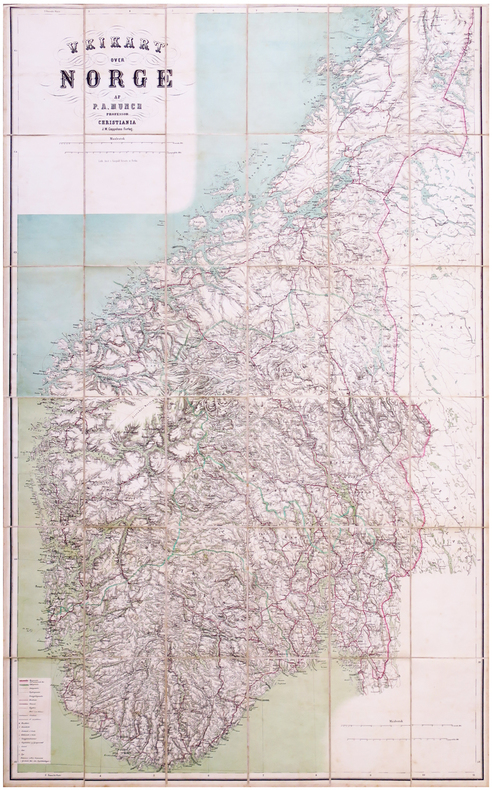
MUNCH (Peter Andreas).
[NORVÈGE] Veikart over Norge.
Christiana, J.W. Cappelens, 1867. En 36 sections montées sur toile et pliées, formant une carte de 1,21 x 0,76 m ; étiquette de la Librairie militaire J. Dumaine au dos ; sous étui de papier marbré avec titre en lettres dorées au dos.
Référence libraire : LBW-6513
|
|
|
MUNCHEN. . .
Brunn's Plan von M?nchen.
Plan 50x65 cm. Repli?.
|
|
|
Mundys Maps
Resources and Road Map of Western Canada
Vancouver BC: Mundy Map Co. 1956 Large folding map about 2' by 3' VG condition in folder two small corner tears. Shows BC. Alberta Yukon and parts of Alaska and NWT. 1956 printing 1952 copyright four colour printing. . Mundy Map Co. unknown
Référence libraire : ww0199
|
|
|
Munn M. J. Illustrated by Maps
Topographic and Geologic Survey of Pennsylvania . Report No. 1 Geology of the Oil and Gas Fields in Sewickley Quadrangle
Harrisburg PA: Aughinbaugh 1910 1910 Hardcover. VG/NA. 1st. 8vo - over 7�" - 9�" tall. VERY SCARCE: 171 PAGES WITH TEXT MAPS AND GRAPHS. Bagged for Preservation. Harrisburg, PA: Aughinbaugh, 1910 hardcover
Référence libraire : 010689
|
|
|
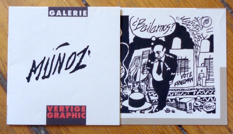
Munoz:
Bailamos ?
Vertige Graphic, 1996. Flyer d'invitation au vernissage de l'exposition" José Munoz - Bailamos ? - Un regard sur le tango", à l'occasion de la Fête de la musique 1996. Format A4, plié en 4.
Référence libraire : 9046
|
|
|
MUNSTER
Carte couleurs au 1/50 000e. Carroyage kilom?trique. Type 1922. Tirage de 1944.
Une feuille 60x78 cm.
|
|
|
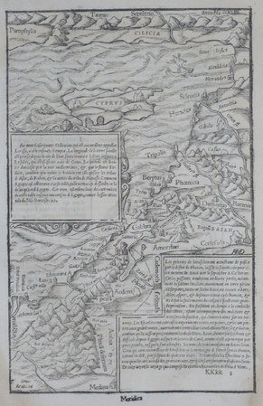
MUNSTER (Sebastian);
[CHYPRE/TERRE SAINTE].
1555 263 x 169 mm.
Référence libraire : LBW06203
|
|
|
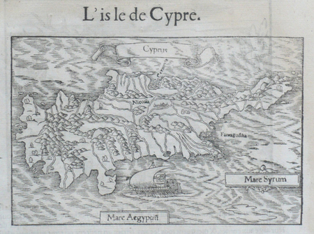
MUNSTER (Sebastian);
[CHYPRE] L'Isle de Cypre.
1555 96 x 150 mm.
Référence libraire : LBW06206
|
|
|
MUNSTER (Sebastian);
[ITALIE DU NORD].
1555 228 x 172 mm.
Référence libraire : LBW061fe
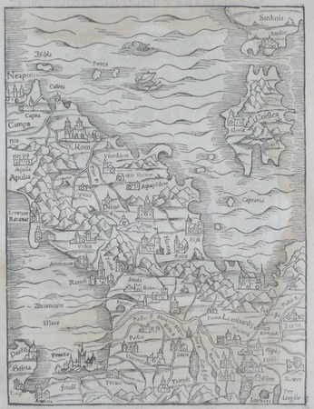
|
|
|
MUNSTER (Sebastian);
[PADOUE] Padoue.
1555 65 x 102 mm.
Référence libraire : LBW06205
|
|
|
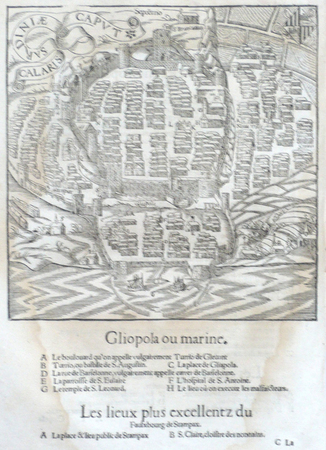
MUNSTER (Sebastian);
[SARDAIGNE] Calaris Sardiniae caput.
1555 181 x 179 mm.
Référence libraire : LBW06200
|
|
 Recevoir par e-mail
 Télécharger en PDF
 Flux RSS


