|
Gordon A Craig with maps by Clarice Borio
THE GERMANS
G P Putnam's Sons New York 1982 Hardcover with dust jacket Ours is and ex-library copy in transparent protective covering with usual stamps stickers etc and barcode cut from endpaper. GOOD book in GOOD unclipped dust jacket In the years since the end of World War II Germany has evolved - an evolution which is less than transparent; with the press concentrating on the so-called Economic Miracle. Yet Germany has become a true democracy every aspect of life has altered to some degree from the family itself to the universities the military and the political climate. G P Putnam's Sons, New York hardcover
Referencia librero : 44756
|
|
|
Gordon, Susan
Explore Britain's Villages
No marks or inscriptions. No creasing to covers or to spine. A very clean very tight copy with bright unmarked laminated boards and no bumping to corners. 160pp. The history of change and development in Britain's villages is an intriguing story, described in the introduction to this book. Over 115 villages are featured and beautifully illustrated, from cosy thatched cottages, to the wild and remote hamlets of the Scottish Highlands.

|
|
|
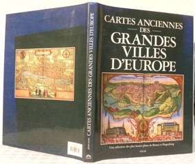
GOSS, John.
Cartes anciennes des grandes villes d’Europe. Une sélection des plus beaux plans de Braun et Hogenberg.
Paris, Solar 1992, 385x290mm, 143pages, reliure d'éditeur sous jaquette. Bel exemplaire.
Referencia librero : 62510
|
|
|
GOSPORT.
Burrows Pointer Guide Map of Gosport including Lee-on-the-Solent & Stokes Bay.
Large folding map printed in red and black on paper measuring 25.0 x 20.0 ins (approx. 63.5 x 51.0 cms) folding in 12 panels to 10.0 x 6.25 ins (approx. 25.5 x 16.0 cms); original printed wrappers, folded as issued, yapped edges, a very good, bright, clean copy. With the original 'pointer' tape mounted on map.'With the aid of the pointer any important street, public building, or any feature of interest may be instantly found'. Copies with the original pointer intact are scarce.

|
|
|
GOSPORT.
Burrows Pointer Guide Map of Gosport including Lee-on-the-Solent & Stokes Bay. Third Edition.
Large folding map printed in red and black on paper measuring 25.0 x 20.0 ins (approx. 63.5 x 51.0 cms) folding in 12 panels to 10.0 x 6.25 ins (approx. 25.5 x 16.0 cms); original printed wrappers, folded as issued, yapped edges, a very good, bright, clean copy. With the original 'pointer' tape mounted on map. 'With the aid of the pointer any important street, public building, or any feature of interest may be instantly found.' Copies with the original pointer intact are scarce.

|
|
|
Got Yves:
Impressions.
P.M.J éditions. Carte postale, à l'état de neuf.
Referencia librero : 973
|
|
|
GOTHARD par Karl LÜÖND et Karl ITEN.
Le Saint-Gothard.Histoire, contes. Richement documenté (planches en couleurs, photos, cartes, figures).
Ed. Ringier 1980. Bel exemplaire relié, reliure pleine toile et jaquette ornées d'éd., gd. in-4, 192 pages.
Referencia librero : AUB-5329
|
|
|
Got Yves:
Petite sérigraphie.
Petite sérigraphie coquine, format carte postale. A l'état de neuf.
Referencia librero : 968

|
|
|
Gota Kanal With Two Maps
Geschichte der Schiffbarmachung der G�tha Elf und vorz�glich der F�lle bei Trollh�tta bis 1802. History of the Navigability of the G�ta �lv River Particularily in the Area of the Trollh�tta Falls until 1802.
Weimar: Industrie-Comptoirs 1805. 8vo. Text is in German. This is a complete monthly issue containing the above mentioned account and two other of the same subjectlus 2 fold-out maps for illustration. Maps measure approximately 20cm x 16.5cm and 11.5cm x 23cm respectively. A scarce primary resource with 21 pages pertaining to the Gota River Canal attractively bound booklet style in recent blue paper covers with label. This issue contains speculation on the navigatability of the G�ta �lv river contemporay to the work of Baltzar von Platen on opening a canal. Reveals proposals and potential for commerce highlighting the area of Trollhatta and accompanied by two scarce maps one showing the canal route from G�teborg to V�nersborg on Lake V�nernone and the other of featuring the section of the Gota between Trollhatta and Lake V�nernone. Further includes two separate commentaries on the following contemporary books on the same then popular subject: "Trollh�tte Canalfartens Historia" by P.A. Granberg and "Description des cataractes et du canal de Trollh�tta en Su�de; avec un pr�cis historique" by A. F. Skj�ldebrand. These are the original pages and maps printed in 1805 and NOT a reprint. This narrative is from a rare multi-volume geographical and scientific journal titled "Allgemeine Geographische Ephemeriden" which issued fifty volumes from 1798-1816 and which encompassed critical contemporary topics of geography and astronomy. Adam Christian Gaspari and Franz Xaver von Zach were editors of this important scientific journal. . Industrie-Comptoirs unknown
Referencia librero : 023579

|
|
|
Gottschalk Louis R. Illustrated by Maps in Color
THE ERA OF THE FRENCH REVOLUTION 1750-1850
Cambridge Massachusetts: The Riverside Press 1929. Used - Acceptable. Acceptable condition. Book Very Good. No dust jacket. Cambridge, Massachusetts: The Riverside Press, 1929 unknown
Referencia librero : P10G-00314
|
|
|
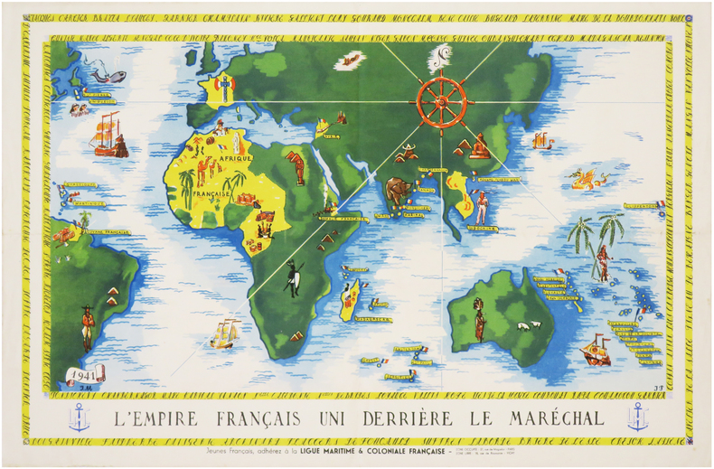
GOUVERNEMENT de VICHY.
[PROPAGANDE SECONDE GUERRE MONDIALE] L'Empire français uni derrière le Maréchal. Jeunes Français, adhérez à la Ligue Maritime & Coloniale Française.
1941. Affiche en couleurs de 305 x 470 mm.
Referencia librero : LBW-7405
|
|
|
GOUDRIAAN (B. H.)
Carte des rivières le Haut et le Bas Rhin, le Lek et la Nouvelle Meuse. depuis Lobith jusqu'à Brielle, en vingt feuilles, avec deux feuilles supplémentaires pour le Vieux-Rhin et pour le Nord
Paris, Dépot des Cartes et Plans de la Marine, 1868 in-4 à l'italienne, titre, 20 planches, une grande planche repliée (carte index), demi-percaline bleue (rel. de l'époque). Ex-libris Exelmans.
Referencia librero : 155847
|
|
|
GOUILLOUX (Noël).
Menu illustré d'une gravure originale signée.
Paris Les Impénitents 1973 2 vol. Broché Menu dépliant sur Arches illustré d'une eau-forte (14 x 7 cm) signée par Noël Gouilloux. En parfait état.
Referencia librero : 109103
|
|
|
GOUILLOUX (Noël).
Menu illustré d'une gravure originale signée.
Paris Les Impénitents 1973 2 vol. Broché Menu dépliant sur Arches illustré d'une eau-forte (14 x 7 cm) signée par Noël Gouilloux. En parfait état.
Referencia librero : 109103
|
|
|
Goulzadian, Anne
L'empire du dernier tsar. 410 cartes postales 1896 - 1917
Éditions Astrid (Collection "Les Peuples par l'image"), 1982. 32 cm ; kart.
Referencia librero : 91239

|
|
|
Government of British Columbia
British Columbia Invites You To the Land of the Golden Twilight (document 25M-330-9790)
36 pages. Incudes 17 pages of maps of Provincial locales. Sepia-tone reproductions of photos of picturesque Provincial scenes. Unmarked. Average wear and external soiling. Binding intact. A sound copy of the lovely B.C. tourism memento. Book

|
|
|
GPO. 1933.; 2 large foldout maps. Illustrator G. P.
Sailing Directions for the Pacific Islands Eastern Groups Volume II
G.P.O Washington D.C 1/1/1933. Hardcover. Good. Supplement. Bound in publishers olive cloth. Gilt lettering to front cover and spine. Good binding and cover. Soiling to boards and spine. Errata intensively throughout volume updated from 1936 as noted by errata title page. Name to front pastedown. Soiling to title page. Tanned pages. Wear to a few pages. Ships daily. G.P.O, Washington, D.C hardcover
Referencia librero : 1511100003
|
|
|
GRALL, Jeanne.
1944 : Le Calvados en images.
Bruxelles, SODIM 1977. Hardcover in-4, 121 pages illustrees en n&b, cartonnage illustre de l"editeur.
Referencia librero : 32697
|
|
|
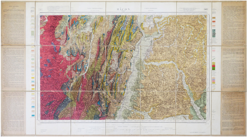
GRANDJEAN (François).
[MÂCON/GÉOLOGIE] Carte géologique détaillée. Mâcon. Feuille n°148.
1941. En 21 sections montées sur toile et repliées, formant une carte de 0,65 x 1,19 m ; étiquette au dos.
Referencia librero : LBW-7868
|
|
|
GRASSI (Ranieri).
[PISE] Il Campanile di Pisa.
[circa 1830]. 203 x 126 mm, 268 x 195 mm avec l'encadrement gouaché.
Referencia librero : LBW-8415

|
|
|
GRASSI (Ranieri).
[PISE] Veduta generale della Piazza del Duomo di Pisa.
[circa 1830]. 139 x 203 mm, 195 x 279 mm avec l'encadrement gouaché.
Referencia librero : LBW-8454

|
|
|
GRASSI (Ranieri).
[PISE] Il Duomo di Pisa - Le Dôme de Pise.
[circa 1830]. 140 x 202 mm, 198 x 264 mm avec l'encadrement gouaché.
Referencia librero : LBW-8453

|
|
|
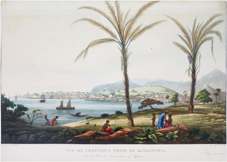
GRAY (James).
[SIERRA LEONE/FREETOWN] Vue de Freetown prise de Kingstown, sur la côte de Sierra Leone en Afrique.
[circa 1830]. 307 x 436 mm.
Referencia librero : LBW-8071
|
|
|
GRANDIDIER Guillaume
Atlas des colonies françaises. Protectorats et territoires sous mandat de la France
Paris Société d'éditions géographiques, maritimes et coloniales s.d. [1934] in-folio demi-toile marron à coins, dos lisse muet, titre poussé sur le plat supérieur [reliure de l'éditeur], fente à une charnière, qq. taches sur le plat supér
Referencia librero : 39286
|
|
|
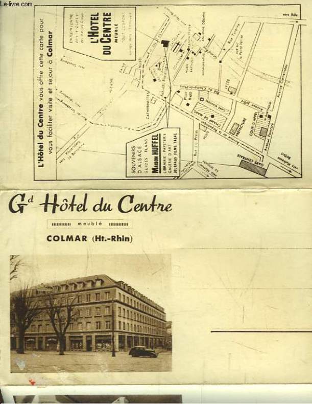
GRAND HOTEL DU CENTRE, à COLMAR
Carte Postale Ancienne Publicitaire du Grand Hôtel du Centre, Colmar (Haut-Rhin)
CHEZ L'AUTEUR. Non daté. In-8. En feuillets. Bon état, Couv. convenable, Dos satisfaisant, Intérieur frais. Carte Postale dépliante en 3 volets. Quelques photos en héliogravure et un plan en noir et blanc.. . . . Classification : 220-Cartes Postales Publicitaires
Referencia librero : RO80092901
|
|
|
GRANGEZ
CARTE DEPARTEMENT DU CALVADOS
1950 rel. toil. rouge in-12, d. passé, étiquette éd. / 1er pl., carte en coul. avec les armes de caen, région nord n ° 15, carte imprimée par monin, revue et rectifiée par grangez, et gravée / acier par laguillermie et abel malo - s.d. - atlas des départements de france
Referencia librero : 936
|
|
|
GRAF, J.H. & LOCHMANN, J.J.:
Index général et compléments pour les fascicules IIa-c, contenant géodésie suisse, catalogues de collections de cartes, cartes, plans reliefs et panoramas. / Generalregister, Ergänzungen und Nachträge zu den Fascikeln II a-c. ‘Bibliographie der schweizerischen Landeskunde’, Fasz. IId.
Bern, Wyss, 1896, gr. in-8°, IV + p. 491-712 + XXVI, brochure originale.
Referencia librero : 11422aaf
|
|
|
GRAND - MESNIL Marie-Noële,
La forêt de Fontainebleau en cartes postales anciennes,
Publications du Pélican, 1982, 158 pp., broché, traces d'usage, couverture légèrement dépelliculée, état correct.
Referencia librero : 64647
|
|
|
GRAVIER, Henri.
La Colonisation de la Louisiane à l'époque de Law. Octobre 1717 - Janvier 1721.
Paris, Masson et Cie, éditeurs, 1904. In-8 - 16x24cm. Broché, couverture rempliée. 2ff, IV, 78pp, 2 cartes. Ouvrage rare. Tirage à très petit nombre d'exemplaires. Bien complet de sa grande carte dépliante in fine.
Referencia librero : 1623

|
|
|
GRAND-MESNIL MARIE-NOËLLE.
LA FORET DE FONTAINEBLEAU EN CARTES POSTALES ANCIENNES.
Publications du Pélican, 1982, in 4 broché, 158 pages. Très nombreuses reproductions en n&b, bibliographie. Bon à très bon état.
Referencia librero : 3512
|
|
|
GRASSET de SAINT-SAUVEUR (Jacques).
Tableau des principaux peuples de l'Europe.
Paris, Bance, le jeune An 7 [1799]. 515 x 612 mm.
Referencia librero : LBW-5390

|
|
|
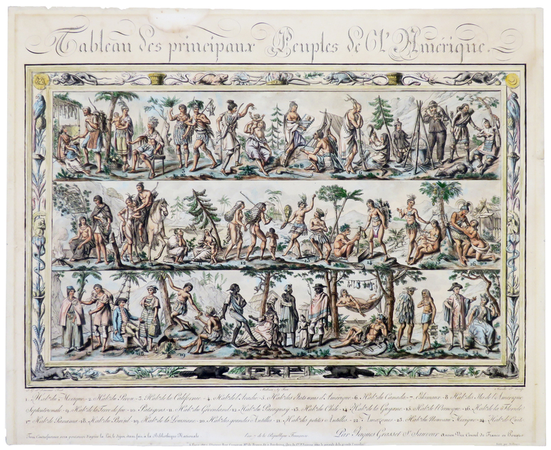
GRASSET de SAINT-SAUVEUR (Jacques).
Tableau des principaux peuples de l'Amérique.
Paris, chez l'auteur, An 7 [1799]. 417 x 497 mm, montée sur carton et sous passe-partout.
Referencia librero : LBW-5392
|
|
|
GRANDPRÉ, Louis Marie Joseph O'Hier de
Voyage à la côte occidentale d'Afrique, fait dans les années 1786 et 1787 contenant la description des moeurs, usages, lois, gouvernement et commerce des états du Congo, fréquentés par les Européens, et un précis de la traite des Noirs, ainsi qu'elle avait lieu avant la Révolution Française ; suivi d'un voyage fait au Cap de Bonne-Espérance, contenant la description militaire de cette colonie.
Paris, Dentu, 1801. 2 vol. in-8, (2) ff., 226 pp. ; (2) ff., 320 pp., 2 cartes, un plan et 8 pl. dépl., mouillures claires, relié demi-veau à coins de l'époque , dos lisse avec pièce d’auteur et titre , mouillure au 1er tome sur les 10 premiers feuillets , déchirures aux plis de 2 gravures.
Referencia librero : PHO-1139
|
|
|
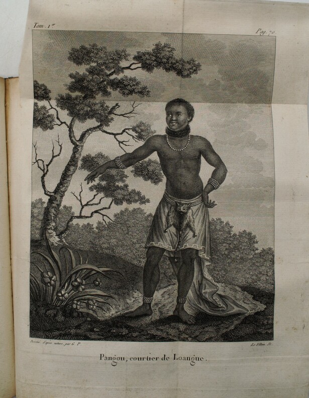
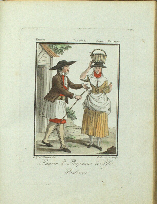
GRASSET DE SAINT-SAUVEUR (Jacques).
Voyages pittoresques dans les quatre parties du monde, ou troisième édition de l’Encyclopédie des voyages, Contenant les Costumes des principaux Peuples de l’Europe, de l’Asie, de l’Afrique, et des Sauvages de la mer du Sud ; gravés et coloriés avec soins. Suivis d’un Précis historiques sur les Mœurs de chaque Peuple. Planches Seules
Paris, Madame veuve Hocquart, 1806, in-8, sous étui, 123 planches (160) en couleurs, gravées par Lachaussée Jeune, de costumes d'Europe (50 sur 80), d'Asie (34 sur 36), d'Afrique (18) et d'Amérique (21 sur 22), accompagnées de 5 cartes en couleurs (Amérique septentrionale, Amérique méridionale, Afrique, Asie, Europe, toutes datées de 1806, sur 6), manque les 4 frontispices, tache sur une planche sinon aucun défaut.
Referencia librero : PHO-1894

|
|
|
GRASSET DE SAINT-SAUVEUR (Jacques).
Voyages pittoresques dans les quatre parties du monde, ou troisième édition de l’Encyclopédie des voyages, Contenant les Costumes des principaux Peuples de l’Europe. Suivis d’un Précis historiques sur les Mœurs de chaque Peuple. EUROPE seule.
Paris, Madame veuve Hocquart, 1806, petit In-4, basane havane, dos lisse orné de compartiments finement dorés avec pièces de titre, plats ornés d'une frise dorée formant encadrements, dentelle intérieure dorée, tranches dorées. Ex-libris G. Cottereau (Coins frottés, coiffe supérieure abimée, frottements, quelques légères rousseurs.
Referencia librero : PHO-1913
|
|
|
Graham Eleanor Editor Illustrated by Maps and Design By Gary Gore & Maps and Design By Gary Gore
Nashville A Short History and Selected Buildings
Historical Commission of Metropolitan Nashville-Davidson 1974. Near Fine. 1974. Softcover. Near Fine softcover edition no names or marks. Minor shelf wear to cover. ; 8vo 8" - 9" tall; 288 pages . Historical Commission of Metropolitan Nashville-Davidson, 1974 paperback
Referencia librero : 33860
|
|
|
Graham L. B. cover illsutration by Larry Elmore maps by Steve Mitchell
BEYOND THE SUMMERLAND: BOOK 1 THE BINDING OF THE BLADE
Phillipsburg NJ: P&R Publishing 2004. Very Good. 2004. First Edition. Trade Paperback. 0875527205 . First edition. "Summary: Joraiem and other young members of Novaana the ruling class of men train in Summerland to rue Kirthanin and to defend it against the evil schemes of Malek". Pictorial wrappers 593 pages. VG copy spine slightly cocked and lightly creased shallow light corner creasing. . P&R Publishing [2004] paperback
Referencia librero : 64406 ISBN : 0875527205 9780875527208

|
|
|
Graham, Melissa
Trans Canada Rail Guide
Appears unread. No marks or inscriptions. No creasing to covers or to spine. A lovely clean very tight copy with bright unmarked boards and no bumping to corners. 256pp. With rail routes and maps plus city guides to most Canadian cities.

|
|
|
GRALL, Jeanne.
1944 : Le Calvados en images.
Hardcover in-4, 121 pages illustrees en n&b, cartonnage illustre de l"editeur. Tres bel exemplaire (dos leg. insole). [P-38]
|
|
|
Gramfors Bo and Eklund Siv and Maps International
Concise Earth Facts
Denver CO: Earthbooks Inc. Good in Good dust jacket. 1990. Hardcover. Lightly used copy with mild signs of handling at edge of cover and dust jacket. Dust jacket has small edge tears. DJ improved with new clear Brodart mylar cover. ; Small 8vo 7�" - 8" tall; 184 pages . Earthbooks Inc hardcover
Referencia librero : 26356 ISBN : 1877731048 9781877731044

|
|
|
GRAND TREMBLEY. . .
Carte au 1/20 000e. Sans date.
Une feuille 46x64 cm.
|
|
|
Granzer, Randolf
Reichenberg - Stadt Und Land Im NeiBetal
796 pages. Written in German. Abundantly illustrated with black and white photographs. Includes two detailed maps stored in pocket inside back board. "Dieses Buch sollte ein Werk unseres hochverdienten Heimatfreundes Josef PreuBler werden. Es kam nicht dazu. Der Tod riB dieson besten Kenner unsurer Heimat and Bewahrer ihrer werte viel zu fruh aus unserer Mitte. Bis zur Halfte des 18. Jahrhunderts war die "Geschichte" fertiggestellt. Doch die Vielen LebensauBerungen unserer Stadt auf allen Gebieten der Kultur, Wirtschaft und Kunst blieben ungeschrieben. Wie aber wuBte er unsere Heimat gerade aus dieser Sicht in unzahliegn Vortragen, Beitragen, besonders fur die Reichenberger Zeitun und in Buchern vollendet darzustellen! Auch das Reichenberger archiv verdankt ihm eine Sammlung wertvollster Unterlagen, die er durch sein Ansehen in einem groBen BekanntenKreis und durch einen jahrelangen, umfangreichen Briefwechsel gewinnen konnte. So war reiches Material vorhanden, das nun fur den ganzen Inhalt des Buches verwendet werden konnte. Ohne seine bemuhungen hatte es nicht geschrieben werden konnen. So gesehen ist es in den Grundlagen auch sein Werk." - from Author's Foreward. Blue cloth boards decorated with partially worn gilt lettering and graphic. Front hinge open. Bit of writing upon front endpaper and reverse side of one map, else generally clean and unmarked. Contents partially yellowed. Average wear to book. Dust jacket heavily worn. Remains a useful copy. Book
|
|
|
Gras Alexandre Le; France. Depot des cartes et plans de la Creator
Mer De Chine: Instructions Nautiques Sur Les Iles Et Les Passages Entre Les Philipines Et Le Japon Et Les Iles Du Japon. French Edition
Nabu Press 2012-01-18. Paperback. Good. Nabu Press paperback
Referencia librero : SONG127257377X ISBN : 127257377X 9781272573775

|
|
|
Grau, J.
Acapulco
No marks or inscriptions. A very clean very tight copy with bright unmarked boards and no bumping to corners. Dust jacket not price clipped or marked or torn with rubbing/nicks to corners. 94pp. A guide to Acapulco in Mexico -- very well illustrated in colour. Scarce in the UK.

|
|
|
Grauert, Hans / Remmert, Reinhold
Theory of Stein Spaces.
Berlin, Heidelberg : Springer (Classics in Mathematics), 2004. XXI, 254 S. (23,5 cm) Broschierte Ausgabe
Referencia librero : 62366
|
|
|
Gray, Terence.
"AND IN THE TOMB WERE FOUND." Plays and Portraits of Old Egypt. With Illustrations by W. M. Brunton.
pp. xxii, 236 + Frontis and full page drawings and maps by W. M. Brunton. Inked ownership of Mrs. C. F. Klunk, York, Pa. Tall 8vo. Original full green cloth binding, gold lettered. Binding slightly soiled. Hardbound. Includes pieces on: the Kyksos; Dirges; and the Songs in the Tomb of Yntuf the Justified.HOLY LAND BOX 1
|
|
|
GRELIER Joseph 64 planches hors texte en héliogravure - 8 planches hors texte en couleur - 22 cartes et croquis dans le texte.
Cuba, carrefour des Caraïbes.
Couverture rigide. Cartonnage de l'éditeur. 356 pages. Jaquette défraîchie.
Referencia librero : 28965
|
|
|
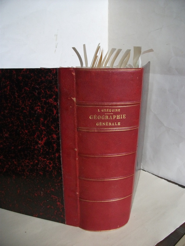
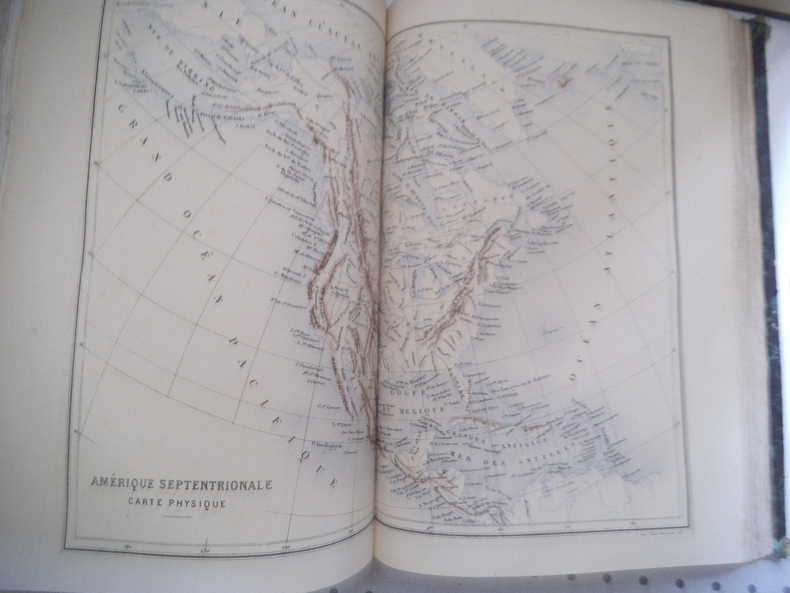
GREGOIRE L.
Géographie générale.
physique,politique et économique,fort in 4 demi-chagrin rouge à nerfs,titre,filets dorés.Faux-titre,frontispice en chromolithographie indien Mandan Etats-Unis,titre avec vignette,1210 pages,16 gravures hors-texte en chromolithographie,20 illustrations hors-texte gravées sur acier, plus de 300 gravures sur bois dans le texte et à pleine page et 100 cartes dans le texte et hors texte en noir et en couleurs.. Garnier frères 1888 quelques rousseurs à certaines pages en début et fin de volume
Referencia librero : 6687
|
|
|
GREGOIRE L.
Géographie générale
Géographie générale Physique, politique et économique, fort in 4 demi-chagrin rouge à nerfs, titre, filets dorés. Faux-titre, frontispice en chromolithographie indien Mandan Etats-Unis, titre avec vignette, 1210 pages, 18 gravures hors-texte en chromolithographie, 20 illustrations hors-texte gravées sur acier, plus de 300 gravures sur bois dans le texte et à pleine page et 100 cartes dans le texte et hors texte en noir et en couleurs.. Garnier frères 1876 quelques rousseurs à certaines pages en début et fin de volume. Un manque angle inférieur droit au premier plat
Referencia librero : 13316
|
|
|
GREENHILL, Basil & WILLIS, Lionel:
The Coastal Trade. Sailing Craft of British Waters 900-1900. With paintings by Lionel Willis.
London, The Burton Press, 1975, gr. in-4to, 45 plates in color and 53 black & white illustrations, o. clothbound, o. jacket, o. slipcase.
Referencia librero : 77379aaf
|
|
 Recibir por correo electrónico
 Descargar en documento PDF
 Flujo RSS


