|
Hammerton, J. A. (editor)
Countries of the World : Volume 4 : India to New Orleans
No marks or inscriptions to contents. No creasing to covers or to spine. Contents excellent. A very clean very tight copy with bright slightly marked slightly irregularly sunned boards, minor rubbing to ends of spine and no bumping to corners. 2181-2908pp. A very well-researched and well-wrtten account of the countries and cities across the world which tell us what our world was like 100 years ago with nearly 700 photographic illustrations including about 200 in full colour or photogravure. Undated ca 1923. A heavy book.

|
|
|
Hammerton, J. A. (editor)
Countries of the World : Volume 5 : New York to Siam
No marks or inscriptions. No creasing to covers or to spine. Contents excellent. A very clean very tight copy with bright unmarked slightly irregularly sunned boards, minor rubbing to ends of spine and no bumping to corners. Fold-out coloured maps of New York and Paris in the 1920s in excellent condition. 2909-3628pp. A very well-researched and well-wrtten account of the countries and cities across the world which tell us what our world was like 100 years ago with nearly 700 photographic illustrations including about 200 in full colour or photogravure. Undated ca 1923. A heavy book.

|
|
|
Hammerton, J. A. (editor)
Countries of the World : Volume 6 : Siberia to Zanzibar
No marks or inscriptions. No creasing to covers or to spine. Contents excellent. A very clean very tight copy with bright unmarked slightly irregularly sunned boards, minor rubbing to ends of spine and no bumping to corners. Fold-out coloured maps of the World in the 1920s in excellent condition. 3629-4348pp. A very well-researched and well-wrtten account of the countries and cities across the world which tell us what our world was like 100 years ago with nearly 700 photographic illustrations including about 200 in full colour or photogravure. Undated ca 1923. A heavy book.

|
|
|
Hammond, Reginald J W
The Isle of Wight : Red Guide
No marks or inscriptions. No creasing to covers or to spine. Very clean very tight pages with bright unmarked boards, a little foxing to page edges and end papers and no bumping to corners. Front map slighlty torn, others in excellent condition. 160pp. Red Guide to the Isle of Wight. We do not use stock photos, the picture displayed is of the actual book for sale. Every one of our books is in stock in the UK ready for immediate delivery.

|
|
|
Hammond, Reginald J W (editor)
Colwyn Bay and North Wales : Red Guide
No marks or inscriptions. A very clean very tight copy with unmarked red cloth boards, a trace of foxing to top of page edges and no bumping to corners. Dust jacket not price clipped or marked or torn or creased. Fold-out maps in excellent condition. 192pp. Red Guide to North Wales covering Anglesey, Llandudno, Colwyn Bay, Conway, Bangor, Caernarvon, Rhyl and Betws-Y-Coed. Third Edition. We do not use stock photos, the picture displayed is of the actual book for sale. Every one of our books is in stock in the UK ready for immediate delivery.

|
|
|
Hammond, Reginald J W (editor)
The Isle of Man (Red Guide)
No marks or inscriptions. No creasing to covers or to spine. A very clean very tight copy with bright unmarked boards, very slightly tanned pages, very minor bump to spine foot and no bumping to corners. Dust jacket clipped but not price clipped and not marked or torn with a little rubbing to upper edge. Fold-out map in excellent condition. 128pp. Red Guide to the Isle of Man. Twelfth edition.

|
|
|
Hammond, Reginald James William
The Highlands of Scotland : Following Road, Rail and Steamer Routes with Tours from Each Centre
No marks or inscriptions. A very clean very tight copy with bright unmarked boards and tiny bump to lower front corner. Dust jacket not price clipped or marked with light creasing and some rubbing/nicks to edges. 160pp.

|
|
|
Hammond; Illustrated with Color Maps
The Historical Atlas 5700 Years of World History
NY : C. S. Hammond 1939. Very Good. 1939. Paperback. This copy is dated 1941. Very good condition some mild rubbing and light edgewear clean and unmarked. 32 pages of color maps. Fun book. . NY : C. S. Hammond (1939) paperback
Référence libraire : 9915
|
|
|
Hannon - Revue libanaise de géographie
Hannon - Recueil des travaux du département de géographie Volume VII - 1972 - Sommaire : Etudes libanaises : "Les précipitations exceptionnelles de Décembre 1968 et janvier 1969 au Liban" (G. BLANCHET) - "Sur la nature de l'horizon B dans les sols rouges méditerranéens du Liban-Sud" (W. VERHEYE) - "Rivages marins du Günz-Mindel dans la région d'Enfé (Liban-Nord)" (R. DALONGEVILLE et P. SANLAVILLE) - "Tableaux et Préhistoire libanaise (1ere partie)" (J. BESANÇON, L. COPELAND et F. HOURS) - Etudes Moyen-Orientales : "Une spéculation originale : l'astrakhan en Afghanistan" (D. BALLAND) - "Contribution à l'étude des bioclimats et de la végétation naturelle en Turquie" (I. NAHAL) - Documentation Géographique : "Exploration de la résurgence de nabaa el Labane" ( A. MAROUN, M. MAJDALANI, A. COMATY) - "Documents de cartographie antique (II) : l'époque romaine" (O. AURENCHE) - "La cartographie arabe jusqu'au Xème siècle" (KAHWAJI) - Notes : "Chroniques cartographique" (N. KANAAN-ATALLAH) - "Traduction en langue arabe des résumés" (Mme I. MAKKI)
1972 Université Libanaise Faculté des Lettres 1972 - In-8 broché - 184 pages
Référence libraire : 82010
|
|
|
HANOT (H.G.).
Tableau démonstratif de l'origine des principales fourrures.
Paris, Monrocq, 1917. 0,87 x 1,10 m ; entoilée.
Référence libraire : LBW-7364

|
|
|
Handtke, F
General-Karte von Deutschland. - entworfen und gezeichnet von F. Handtke. Verhältniss 1:1791000
Glogau, C. Flemming Verlag, 1849. in 20 lithogr. Segmenten mit Grenzkolorit auf Leinwand. Original-Faltkarte, gefaltet 8°
Référence libraire : 12988

|
|
|
Handtke, F
Reise-Karte von Deutschland.und den Nachbar-staaten bis Kopenhagen, Dover, Paris, Lyon, Turin, Ferrara, Budapest, Debreczin, Lublin, Grodno, Tauroggen. - entworfen und gezeichnet von F. Handtke. Verhältniss 1: 500.000
Glogau, C. Flemming Verlag o.J., circa, 1890. Neueste revidierte Ausgabe. in 52 lithogr. Segmenten mit Grenzkolorit auf Leinwand. (ziegelroter) OLwd.-Einband, Original-Faltkarte, gefaltet 8°
Référence libraire : 15148

|
|
|
Handtke, F. (Bearb.)
Provinz Pommern. 1 : 520.000.
Berlin u. Glogau, Flemming, o. J. (um 1890?). Farblithogr., 75 x 50 cm mit kl. Nebenkarte von Stettin unten links. In Segmenten auf Leinen aufgezogen. Gefaltet. In OLn., h (Carl Flemmings Generalkarte No. 6).
Référence libraire : 45552AB

|
|
|
Hanigan, Des
Cornwall and the Isles of Scilly
No marks or inscriptions. No creasing to covers or to spine. A lovely clean very tight copy with bright unmarked boards and no bumping to corners. 128pp.

|
|
|
Hansa Rundfahrt GmbH
Rundfahrt-Führer durch Hamburg - Circular-Drives through Hamburg
Hamburg, Norddeutsche Buchdruckerei ca 1922. 36 S., Faltkarte, 22cm Karton 0
Référence libraire : 77553

|
|
|
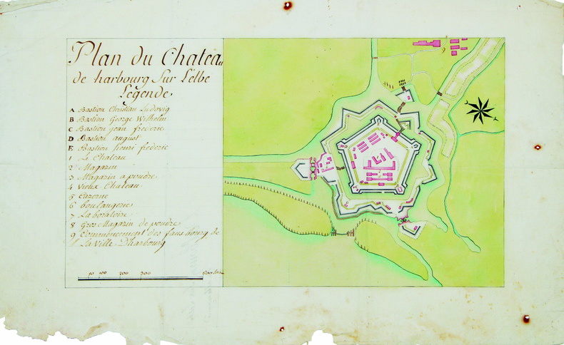
HARBOURG. MANUSCRIT.
Plan du château de Harbourg sur l'Elbe.
[circa 1750]. 240 x 390 mm.
Référence libraire : LBW-4205
|
|
|
Harding, William.
WAR IN SOUTH AFRICA AND THE DARK CONTINENT. From Savagery To Civilization. Including the War With the Boers. And a Detailed History of the Causes and Events of the British-Boer War. Superbly Illustrated With Half-Tone Engravings Made From Photographs
554p. + Plus frontis and color folding map. Full page text half-tone engravings from photographs. Title page printed in red and black. Paper beginning to brown but not brittle. 4to. Original full cloth binding with pictorial design of British soldier, Boer soldier and an African tribesman. Binding slightly soiled. Nice copy. AFRICA/2
|
|
|
Hardwick, Walter G.
Vancouver - Canadian Cities
214 pages including index. A provocative study of Canada's third-largest city which challenges all readers interested in the problems facing urban centres today. Includes 13 maps and 25 photographs. Book
|
|
|
Harris R Cole & Matthews Geoffrey J
Atlas Historique Du Canada: Des Origines a 1800 French Edition
Montreal: Les Presses de L'Universite De Montreal 1987 Canadian history and geography prior to 1800 illustrated with maps and diagrams. 198p.illus bibliographies A large format VERY heavy volume. 14.5x11x1.5" 5lbs 5 oz/ 2.4 kg. First Thus. Hardcover. As New/Near Fine. Les Presses de L'Universite De Montreal hardcover
Référence libraire : 33118 ISBN : 276060800x 9782760608009
|
|
|
Harris, R Cole & Matthews, Geoffrey J
Atlas Historique Du Canada: Des Origines a 1800 (French Edition)
Canadian history and geography prior to 1800 illustrated with maps and diagrams. 198p.illus bibliographies A large format VERY heavy volume. (14.5x11x1.5" 5lbs 5 oz/ 2.4 kg] Book
|
|
|
Harris, Richard
Hidden Idaho
307 pages. Complete travel information. Covers: sightseeing, lodging, dining, annual events, shopping, nightlife, maps, camping, hiking, whitewater rafting, boating, flyfishing, biking, skiing, subterranean sites and mining legends. Book
|
|
|
HARRISON GODFREY with drawings by MILLS DONALD BURFIELD and maps by VERNON LEO
BORTHWICKS - A Century in the Meat Trade 1863 - 1963
Borthwicks London 1963. 212 pp quarto maps on end-papers b&w photographic plates line illustrations maps top edge tinted fine copy in green cloth boards. Borthwicks, London, 1963 hardcover
Référence libraire : 229226
|
|
|
Harrison Fairfax; b/w; Maps in Rear Pocket Illustrator
Landmarks of Old Prince William: a Study of Origins in Northern Virginia Volumes I & II in One book
Gateway Editions; Prince William County Historical Commission 1987-01-01. Hardcover. Good. Bound in publisher's cloth. Hardcover. Good binding and cover. Library stamps and markings. 7 724 pages : maps some folded portraits ; 24 cm. Gateway Editions; Prince William County Historical Commission hardcover
Référence libraire : 1911120042
|
|
|
HARRISON GEORGE H.; PETERSON ROGER TORY INTRODUCTION; HARRISON KIT MAPS & VISITOR TIPS
Roger Tory Peterson's Dozen Birding Hot Spots
Simon and Schuster New York: 1976. Hardcover. Good condition. After turning over in my mind all of the good birding spots I have known . . . I brought things down to the dozen places described in this book." Includes color photographs. ISBN: 0671223291. Simon and Schuster, New York: 1976 hardcover
Référence libraire : 19759X1 ISBN : 0671223291 9780671223298

|
|
|
Harrison Michael introduction by Ellergy Queen endpaper maps by Luther Leon Norris Dust Wrapper by Ronald Clyne
THE EXPLOITS OF THE CHEVALIER DUPIN
Sauk City: Mycroft & Moran. Near Fine in Very Good dust jacket. 1968. First Edition. Hardcover. First edition. Limited to 2000 reportedly actually 1917 copies. 138 pages. Near Fine or better copy in Near Fine or better Dust Wrapper save for some age-toning most obviously to the white spine lettering less so to some edges. . Mycroft & Moran hardcover
Référence libraire : 16297

|
|
|
Harrison Michael introduction by Ellergy Queen endpaper maps by Luther Leon Norris Dust Wrapper by Ronald Clyne
THE EXPLOITS OF THE CHEVALIER DUPIN
Sauk City: Mycroft & Moran. Good in Very Good dust jacket. 1968. First Edition. Hardcover. First edition. Limited to 2000 reportedly actually 1917 copies. 138 pages. Good to Very Good copy dampstaining to the lower portion of the boards which have also been lightly cleaned light top edge foxing slightly ajar; but the contents are tight and clean in otherwise Near Fine Dust Wrapper scattered light toning most evident to the white spine lettering and with a neat vertical fold probably so issued at the front spine edge. . Mycroft & Moran hardcover
Référence libraire : 70728

|
|
|
Harry Seidler
The Grand Tour: Travelling the World with an Architect's Eye
Book appears in mint unread condition. 575pp. Architect Harry Seidler spent more than 50 years traveling the globe, extensively photographing the peak achievements in architecture from 3000 B.C. to the present day. This book represents his achievement.

|
|
|
Hart Albert Bushnell editor; portraits maps Illustrator
COMMONWEALTH HISTORY OF MASSACHUSETTS: COLONY PROVINCE AND STATE 5 volumes
The States History Company. Hardcover. Good. Five Volume set Published from 1927-1929. All books is great shape for age. Blue cloth boards with gold gilt lettering to spine and state symbol to front. Bumped at corners but no fraying. Front end page missing from volume one. Page edges with toning and dust soil. Pages unmarked. Bindings are tight. The States History Company hardcover
Référence libraire : 20060226

|
|
|
Hartley J.; Maps Drawings Photos Illustrator
A GUIDE TO THE LAKE NAIVASHA AREA
Evans Brothers Ltd 1/1/1985. Paperback. Very Good. NICE CONDITION SOFTCOVER BOOK. NO WRITING OR MARKINGS IN TEXT. ONLY LIGHT WEAR TO COVER. A CLEAN & SOLID BOOK. Evans Brothers Ltd paperback
Référence libraire : SKU-73677
|
|
|
Hartmann, Carin
Men's women. Women in postcards.
Keine weiteren Angaben. Um 1980. 4°. Ca. 60 nn. S. mit Abb. in S/W. Geklammerte Broschur.
Référence libraire : 7770A
|
|
|
Hartz, Otto (Bearb.)
Vier Karten zur Geschichte Schleswig-Holsteins (1622, 1721, 1815, 1914). Mit Erläuterungen.
Altona, Hans Ruhe, 1928. 4 farb. mehrf. gefalt. Ktn. im Maßstab 1:500.000, gezeichnet von Ernst Scharstein (ca. 54,5 x 46,5 cm) + Textheft: 66 S., mit 3 gefalt. Stammtaf. Gr.-8vo. 23,5 cm. OBrosch. Zus. in OHLn.-Schuber.
Référence libraire : 37922

|
|
|
Harvey Sir Paul compiled & edited with illusts & Maps
Oxford Companion to Classical Literature The
Oxford at Clarendon Press. HBDJ bkplate 1962 minor rub chip & soil VG/VG AS-IS. Hard Cover. Oxford at Clarendon Press hardcover
Référence libraire : 3902
|
|
|
Harvey Maps
Ben Alder XT25 Superwalker
Harvey Map Services Ltd. Map. New. Harvey Map Services Ltd unknown
Référence libraire : 2-185137549X ISBN : 185137549X 9781851375493
|
|
|
Harvey Maps
Ben Lawers Ultramap
Harvey Map Services Ltd 2016. Map. New. 1st edition. 1 pages. 7.32x3.78x0.39 inches. Harvey Map Services Ltd unknown
Référence libraire : 2-1851375783 ISBN : 1851375783 9781851375783
|
|
|
Harvey Maps
Ben Nevis Ultramap
Harvey Map Services Ltd 2016. Map. New. !st edition. 1 pages. 5.67x3.86x0.24 inches. Harvey Map Services Ltd unknown
Référence libraire : 2-1851375775 ISBN : 1851375775 9781851375776
|
|
|
Harvey Maps
CairnGorm Ultramap
Harvey Map Services Ltd 2016. Map. New. 1st edition. 1 pages. 7.32x3.86x0.01 inches. Harvey Map Services Ltd unknown
Référence libraire : 2-1851375791 ISBN : 1851375791 9781851375790
|
|
|
Harvey Maps
Cannock Chase
Harvey Maps 2007. Paperback. New. 1 pages. Harvey Maps paperback
Référence libraire : 2-1851374132 ISBN : 1851374132 9781851374137
|
|
|
Harvey Maps
Cotswold Way XT40 Route Maps
Harvey Maps. Map. New. Harvey Maps unknown
Référence libraire : 2-1851374183 ISBN : 1851374183 9781851374182
|
|
|
Harvey Maps
Dark Peak BMC British Mountain Map: 1
Harvey Maps. Map. New. Harvey Maps unknown
Référence libraire : 2-1851374825 ISBN : 1851374825 9781851374823
|
|
|
Harvey Maps
Dartmoor North Superwalker XT25
Harvey Maps 2016. Map. New. 1 pages. 9.29x5.67x0.31 inches. Harvey Maps unknown
Référence libraire : 2-185137566X ISBN : 185137566X 9781851375660
|
|
|
Harvey Maps
Dartmoor South Superwalker XT25
Harvey Maps 2016. Map. New. 1 pages. 9.60x5.50x0.40 inches. Harvey Maps unknown
Référence libraire : 2-1851375678 ISBN : 1851375678 9781851375677
|
|
|
Harvey Maps
MacGillycuddys Reeks XT30 Superwalker
Harvey Map Services Ltd 2017. Map. New. 2nd edition. 1 pages. 9.69x4.88x0.39 inches. Harvey Map Services Ltd unknown
Référence libraire : 2-1851376011 ISBN : 1851376011 9781851376018
|
|
|
Harvey Maps
North Downs Way XT40:: 1
Harvey Maps 2013. Map. New. 1st edition. 1 pages. 9.69x5.28x0.31 inches. Harvey Maps unknown
Référence libraire : 2-1851375295 ISBN : 1851375295 9781851375295
|
|
|
Harvey Maps
Skye the Cuillin XT25 Superwalker
2005-04-02. New. Ships with Tracking Number! INTERNATIONAL WORLDWIDE Shipping available. May be re-issue. Buy with confidence excellent customer service! unknown
Référence libraire : 1851374078n ISBN : 1851374078 9781851374076

|
|
|
Harvey Maps
Skye the Cuillin XT25 Superwalker
2005-04-02. Good. Ships with Tracking Number! INTERNATIONAL WORLDWIDE Shipping available. May not contain Access Codes or Supplements. May be re-issue. May be ex-library. Shipping & Handling by region. Buy with confidence excellent customer service! unknown
Référence libraire : 1851374078 ISBN : 1851374078 9781851374076

|
|
|
Harvey Maps
Snowdonia North Ultramap
Harvey Map Services Ltd. Map. New. Harvey Map Services Ltd unknown
Référence libraire : 2-1851375767 ISBN : 1851375767 9781851375769
|
|
|
Harvey Maps
Snowdonia North British Mountain Map
2006-07-05. New. Ships with Tracking Number! INTERNATIONAL WORLDWIDE Shipping available. May be re-issue. Buy with confidence excellent customer service! unknown
Référence libraire : 1851374728n ISBN : 1851374728 9781851374724

|
|
|
Harvey Maps
Snowdonia North British Mountain Map
2006-07-05. Good. Ships with Tracking Number! INTERNATIONAL WORLDWIDE Shipping available. May not contain Access Codes or Supplements. May be re-issue. May be ex-library. Shipping & Handling by region. Buy with confidence excellent customer service! unknown
Référence libraire : 1851374728 ISBN : 1851374728 9781851374724

|
|
|
Harvey Maps
South West Coast Path 2 XT40: St Ives to Plymouth Route Maps
Harvey Map Services Ltd. Map. New. Harvey Map Services Ltd unknown
Référence libraire : 2-1851375554 ISBN : 1851375554 9781851375554
|
|
|
Harvey Maps
South West Coast Path 3 XT40: Plymouth to Poole Harbour
Harvey Map Services Ltd. Map. New. Harvey Map Services Ltd unknown
Référence libraire : 2-1851375562 ISBN : 1851375562 9781851375561
|
|
 Recevoir par e-mail
 Télécharger en PDF
 Flux RSS


