|
NEPTUNE FRANCOIS.
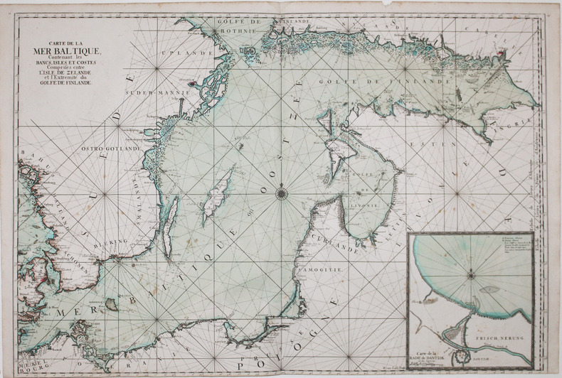
[MER BALTIQUE/SCANDINAVIE] Carte de la mer Baltique, contenant les bancs, isles et costes comprises entre l'isle de Zélande et l'extrémité du golfe de Finlande.
[1693]. 610 x 898 mm.
Referenz des Buchhändlers : LBW-2929
|
|
|
NEPTUNE FRANCOIS.
[MORBIHAN/GROIX & GLÉNAN] 6.me Carte particulière des costes de Bretagne depuis la baye d'Hodierne jusqu'à l'isle de Groa, contenant les isles de Glénan.
[1693]. 580 x 816 mm.
Referenz des Buchhändlers : LBW-2678

|
|
|
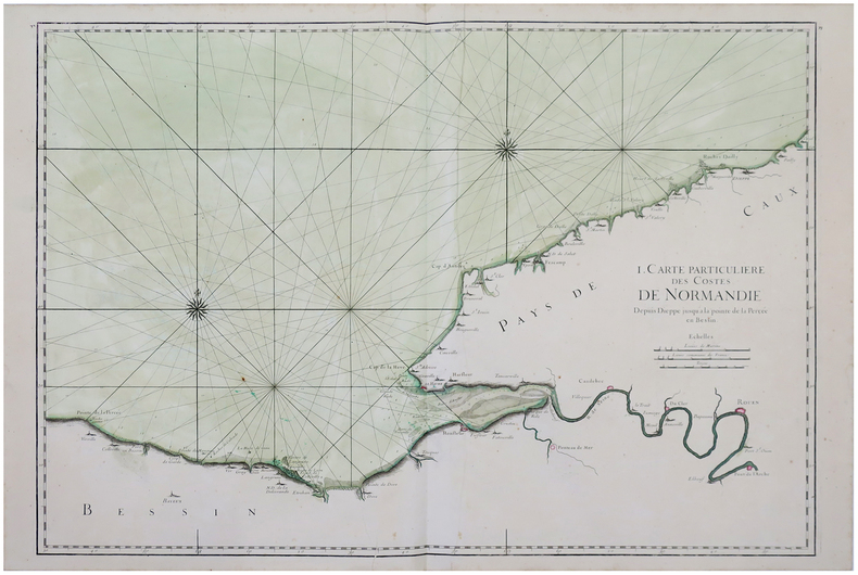
NEPTUNE FRANCOIS.
[NORMANDIE/CALVADOS] I. Carte particulière des costes de Normandie depuis Dieppe jusqu'à la pointe de la Percée en Bessin.
1693. 588 x 859 mm.
Referenz des Buchhändlers : LBW-2886
|
|
|
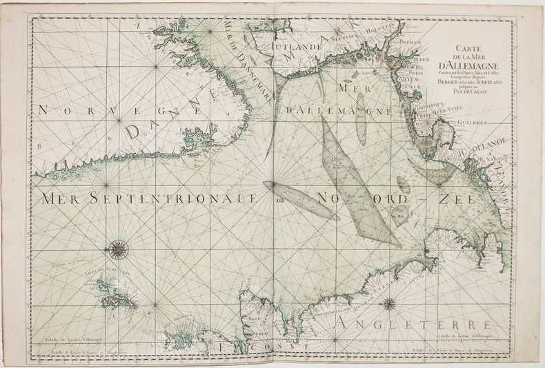
NEPTUNE FRANCOIS.
[NORVEGE & DANEMARK] Carte de la mer d'Allemagne contenant les bancs isles et costes comprises depuis Bergen et les isles Schetland jusques au Pas de Calais.
[1693]. 605 x 851 mm.
Referenz des Buchhändlers : LBW-2933
|
|
|
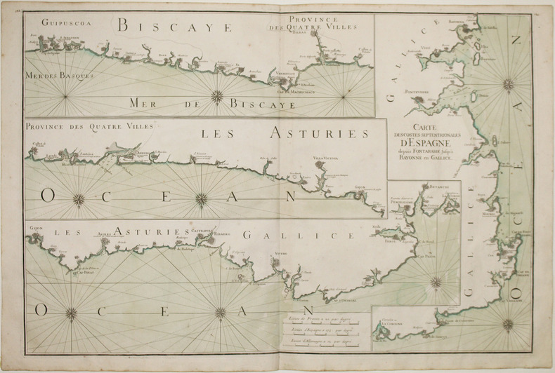
NEPTUNE FRANCOIS.
[PAYS BASQUE & GALICE] Carte des costes septentrionales d'Espagne depuis Fontarabie jusqu'à Bayonne en Gallice.
[1693]. 585 x 873 mm.
Referenz des Buchhändlers : LBW-2928
|
|
|
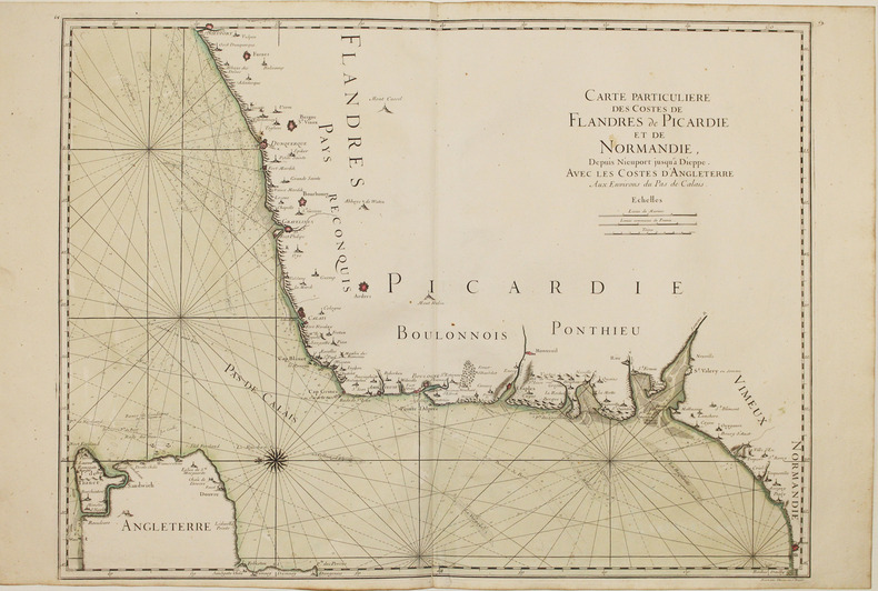
NEPTUNE FRANCOIS.
[PICARDIE & NORD-PAS-de-CALAIS] Carte particulière des costes de Flandres, de Picardie et de Normandie, depuis Nieuport jusqu'à Dieppe. Avec les costes d'Angleterre aux environs du Pas de Calais.
1693. 595 x 804 mm.
Referenz des Buchhändlers : LBW-2887
|
|
|
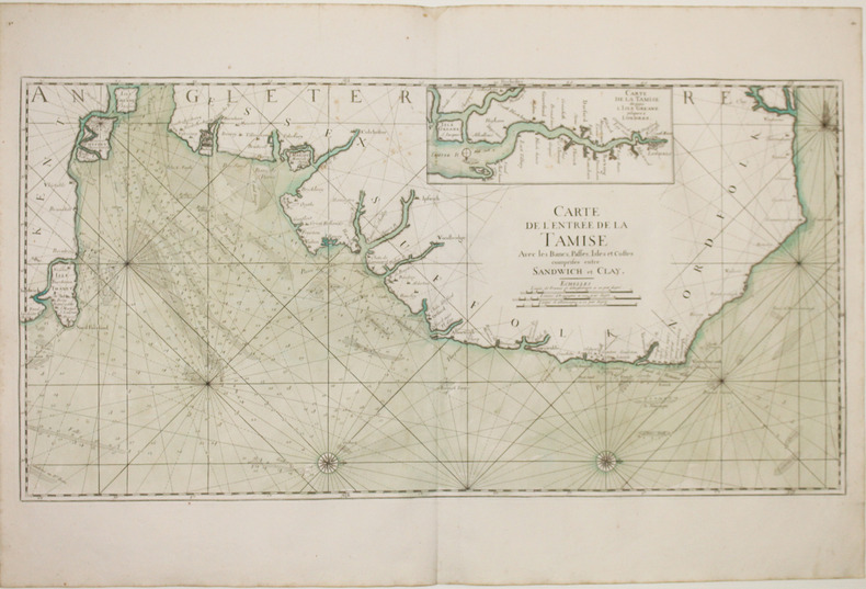
NEPTUNE FRANCOIS.
[TAMISE] Carte de l'entrée de la Tamise avec les bancs, passes, isles et costes comprises entre Sandwich et Clay.
[1693]. 454 x 895 mm.
Referenz des Buchhändlers : LBW-2921
|
|
|
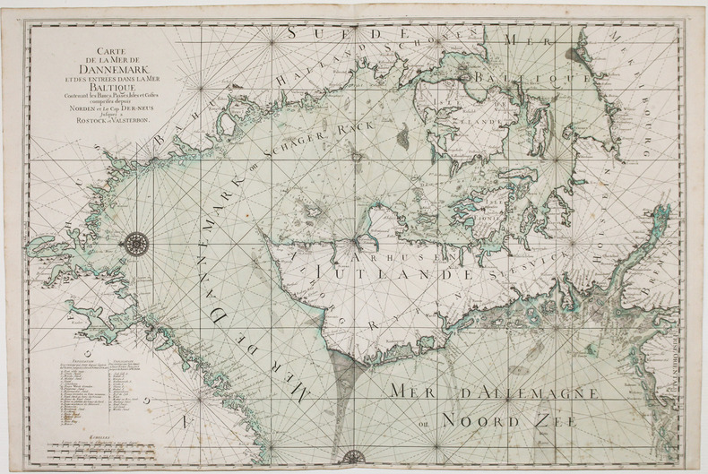
NEPTUNE FRANCOIS.
Carte de la mer de Dannemark et des entrées dans la mer Baltique contenant les bancs, passes, isles et costes comprises depuis Norden et le cap Der-Neus jusques à Rostock et Valsterbon.
[1693]. 607 x 897 mm.
Referenz des Buchhändlers : LBW-2935
|
|
|
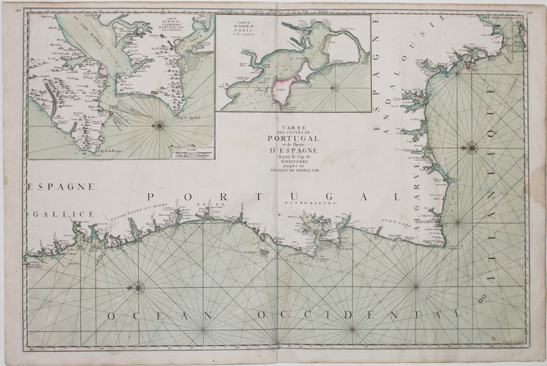
NEPTUNE FRANCOIS.
Carte des costes de Portugal et de partie d'Espagne depuis le cap de Finisterre jusques au dêtroit de Gibraltar.
[1693]. 590 x 880 mm.
Referenz des Buchhändlers : LBW-2927
|
|
|
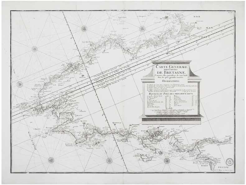
NEPTUNE FRANÇOIS.
[BRETAGNE] Carte générale des costes de Bretagne, comme elles paroissent de mer basse dans les plus grandes marées.
[Paris], Dépôt de la Marine, [circa 1810]. 543 x 753 mm.
Referenz des Buchhändlers : LBW-6248
|
|
|
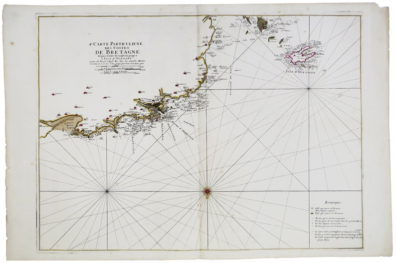
NEPTUNE FRANÇOIS.
[FINISTÈRE/OUESSANT] 4.me Carte particulière des costes de Bretagne depuis l'anse de Goulven jusqu'à l'isle d'Ouessant.
[1693]. 582 x 798 mm.
Referenz des Buchhändlers : LBW-5892
|
|
|
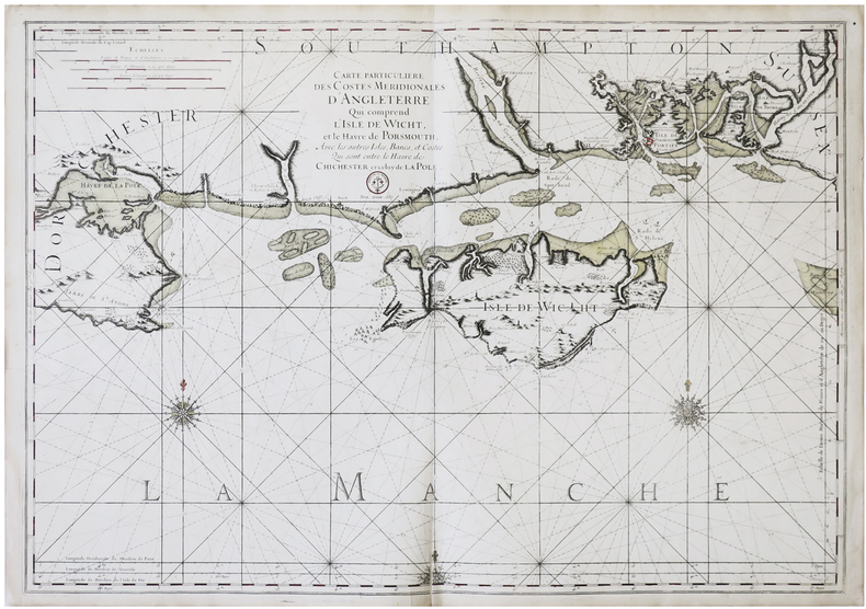
NEPTUNE FRANÇOIS.
[ÎLE DE WIGHT] Carte particulière des costes méridionales d'Angleterre qui comprend l'isle de Wicht, et le havre de Portsmouth, avec les autres isles, bancs, et costes qui sont entre le havre de Chichester, et celuy de La Pole.
1753. 610 x 875 mm.
Referenz des Buchhändlers : LBW-6391
|
|
|
NEUCHÂTEL, INDUSTRIES par René CHARLET et Patrice ALLANFRANCHINI.
Pays de Neuchâtel, métiers et industries par des photographies et des cartes postales anciennes. Richement documenté.
Editions du Ruau 1991. Bel exemplaire relié, cartonnage orné d'éd., in-4, 116 pages avec annexes.
Referenz des Buchhändlers : AUB-7896
|
|
|
NEUDIN
L'officier international des cartes postales 1988
Neudin. 1987. In-8. Broché. Très bon état, Couv. convenable, Dos satisfaisant, Intérieur frais. 536 p., nombreuses illustrations noir et blanc et couleur in texte.. . . . Classification Dewey : 741.68-Illustrations des cartes postales
Referenz des Buchhändlers : RO20025369
|
|
|
NEUDIN
Lyonnais, Beaujolais, Bresse, Forez (la France retrouvée grâce aux cartes postales, tome 3).
Neudin Neudin, sans date (c. 1982), 192 p., broché, bords de la couverture un peu frottés par endroits, bon état et intérieur bien propre.
Referenz des Buchhändlers : 109508
|
|
|
NEUDIN (Gérard et Joelle).
L'Argus International des Cartes Postales.3ème année.
Paris,Neudin,1977 ; grand in-8°,broché,couverture de papier glacé vert illustrée en couleurs; 183pp.,1p.nch.;couverture légèrement poussiéreuse au 2eme plat,petit poinçon en forme d'étoile en haut du 1er plat;ex-libris manuscrit au titre.Bon exemplaire.
Referenz des Buchhändlers : c2392
|
|
|
NEUDIN (Joelle et Gérard).
Premier Catalogue français des Cartes Postales de Collection.
Paris,1975 (1ère édition) ; in-8°,broché,couverture rouge-orange de papier fort illustrée d'une carte postale "Paris.La Grande Roue" ; 80pp.;quelques annotations au crayon en marge; ex-libris manuscrit à l'encre au titre;couverture très légèrement frottée,mais bon exemplaire.
Referenz des Buchhändlers : c2450
|
|
|
NEUDIN (Joelle et Gérard).
Tout sur les Cartes Postales de Collection.
Paris,1976 (2ème année) ; in-8°, broché, couverture de papier fort bleu vif illustrée d'une carte postale ancienne "Circuit de Dieppe"; 81pages; couverture légèrement frottée au 1er plat;ex-libris manuscrit à l'encre au titre, mais bon exemplaire.
Referenz des Buchhändlers : c2451
|
|
|
NEUDIN GERARD ET JOELLE.
L'OFFICIEL INTERNATIONAL DES CARTES POSTALES DE COLLECTION. PARIS. NEUDIN. 1985.
1985 1985 IN-8 BROCHE (15,5 X 22 CENTIMETRES ENVIRON) DE 542 PAGES, COUVERTURE ROUGE ILLUSTREE EN COULEURS.
Referenz des Buchhändlers : 1568
|
|
|
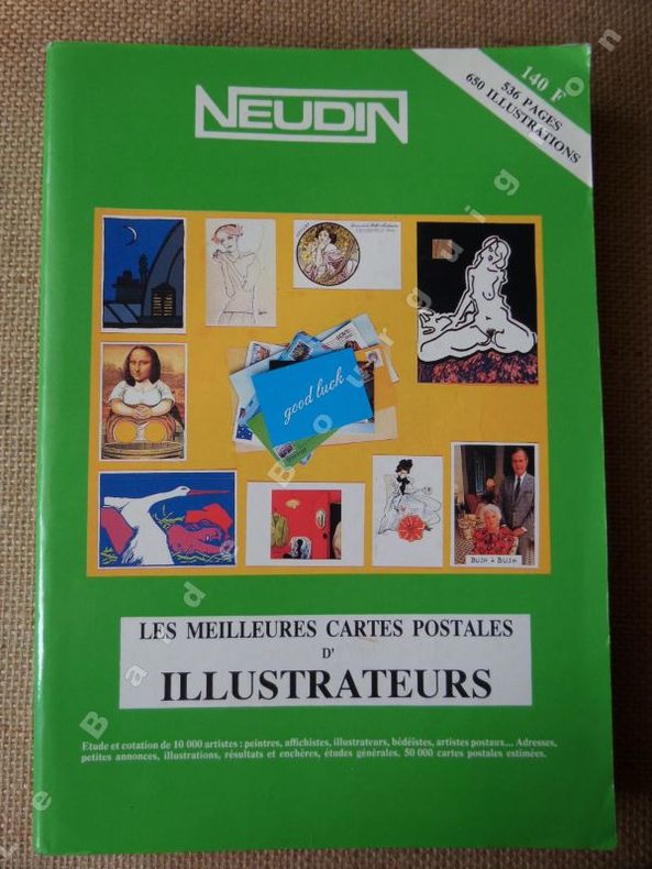
NEUDIN Gérard
L'officiel international des cartes postales de collection. Les meilleures cartes postales d'illustrateurs.
1991 Paris, Neudin, 1991, broché, 15x22 cm, 536 pages, 650 illustrations
Referenz des Buchhändlers : 7809
|
|
|
NEUDIN Gérard
La valeur de vos cartes postales, Neudin
1995, les éditions de l'amateur, in-8 cartonné de 512 pages, couverture illustrée en couleurs, 400 illustrations noir et blanc. | Etat : Très bon état général (Ref.: J5238)
Referenz des Buchhändlers : 9624
|
|
|
NEUDIN Gérard
La valeur de vos cartes postales, Neudin
1997 1997, les éditions de l'amateur, in-8 cartonné de 512 pages, couverture illustrée en couleurs, 400 illustrations noir et blanc. | Etat : Très bon état général (Ref.: J5239)
Referenz des Buchhändlers : 9625
|
|
|
NEUDIN Gérard, NEUDIN Joëlle
Neudin 1981 - cartes postales
1981, Neudin, in-8 broché de 542 pages, couverture jaune illustrée en couleurs, 600 illustrations noir et blanc, et couleurs hors-texte | Etat : Bon état général, couverture légèrement défraîchie (Ref.: ref84027)
Referenz des Buchhändlers : 37025
|
|
|
NEUDIN Gérard, NEUDIN Joëlle
Neudin 1983 - cartes postales
1983, Neudin, in-8 broché de 542 pages, couverture grise, illustrations noir et blanc, et couleurs hors-texte | Etat : Bon état général, couverture défraîchie (Ref.: ref82183)
Referenz des Buchhändlers : 32538
|
|
|
NEUDIN Gérard, NEUDIN Joëlle
Neudin 1984 - cartes postales
1984, Neudin, in-8 broché de 540 pages, couverture dorée, illustrations noir et blanc, et couleurs hors-texte | Etat : Bon état général (Ref.: ref82179)
Referenz des Buchhändlers : 32534
|
|
|
NEUDIN Gérard, NEUDIN Joëlle
Neudin 1985 - cartes postales
1985, Neudin, in-8 broché de 542 pages, couverture rouge, illustrations noir et blanc, et couleurs hors-texte | Etat : Bon état général (Ref.: ref82180)
Referenz des Buchhändlers : 32535
|
|
|
NEUDIN Gérard, NEUDIN Joëlle
Neudin 1986 - cartes postales
1986, Neudin, in-8 broché de 536 pages, couverture noire, illustrations noir et blanc, et couleurs hors-texte | Etat : Bon état général (Ref.: ref82181)
Referenz des Buchhändlers : 32536
|
|
|
NEUDIN Gérard, NEUDIN Joëlle
Neudin 1986 - cartes postales
1986, Neudin, in-8 broché de 536 pages, couverture noire, illustrations noir et blanc, et couleurs hors-texte | Etat : Bon état général, couverture défraîchie (Ref.: ref82182)
Referenz des Buchhändlers : 32537
|
|
|
NEUDIN Gérard, NEUDIN Joëlle
Neudin 1994 - cartes postales
1994, Neudin, in-8 broché de 512 pages, couverture orange illustrée en couleurs, 400 illustrations noir et blanc, et couleurs hors-texte | Etat : Bon état général (Ref.: ref82233)
Referenz des Buchhändlers : 32636
|
|
|
NEUDIN Gérard, NEUDIN Joëlle
Neudin, l'argus international des cartes postales
1977, Neudin, in-8 broché de 183 pages, couverture illustrée en couleurs, illustrations noir et blanc, et couleurs hors-texte. Tous les résultats des ventes, conseils et adresses, classements chronologique, thématique et géographique avec 10 000 rubriques cotées, étude d'environ 3000 illustrateurs. | Etat : Bon état général (Ref.: ref9553)
Referenz des Buchhändlers : 18437
|
|
|
NEUDIN Joëlle et Gérard
REPERTOIRE OFFICIEL INTERNATIONAL DE CARTES POSTALES
1984 broché in-octavo, dos bleu-marine et couverture illustrée en couleurs sur le recto / verso, illustrations : nombreuses reproductions de cartes postales, 538 pages, 1984 Paris Editions Image-Document,
Referenz des Buchhändlers : 1344
|
|
|
NEUFCHATEAU
Carte d'Etat-Major au 1/200 000?. Fin XIXe.
1 feuille repli?e. 32x49 cm.
|
|
|
NEUILLY
Carte au 1/20 000?me. Fin XIXe.
Une feuille. 64x46 cm.
|
|
|
Neumann, R
Über den Angriff auf die Düppeler Schanzen in der Zeit vom 15. März bis zum 18. April 1864. Ein Vortrag gehalten in der militairischen Gesellschaft zu Berlin am 14. November 1864.
Berlin, Druck und Verlag von F. G. Mittler und Sohn, 1865. 8°. 22 cm. 54 Seiten. Einfacher Halblederband der Zeit.
Referenz des Buchhändlers : 8064DB

|
|
|
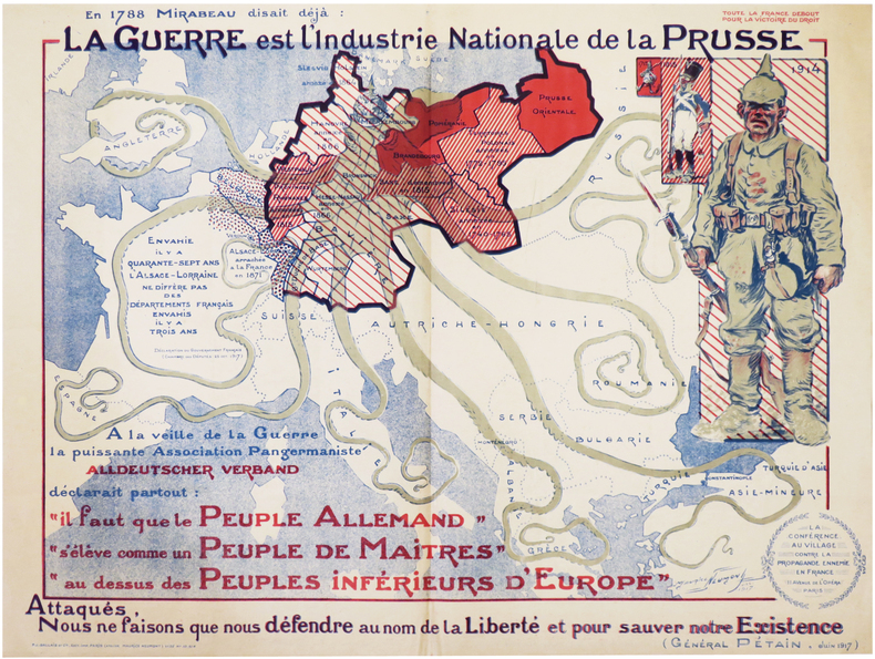
NEUMONT (Maurice).
[PROPAGANDE GRANDE GUERRE] La Conférence au village contre la propagande ennemie en France. En 1788 Mirabeau disait déjà : la Guerre est l'industrie nationale de la Prusse. Attaqués, nous ne faisons que nous défendre au nom de la Liberté et pour sauver notre existence (Général Pétain, juin 1917).
Paris, P.J. Gallais et Cie, Déc. 1917. Lithographie en couleurs de 580 x 775 mm.
Referenz des Buchhändlers : LBW-7258
|
|
|
New Jersey Geological Survey. G. M. Hopkins and T. H. Brooks maps
Geological Survey of New Jersey. Maps. 1868.
Trenton: Geological Survey of New Jersey 1868. Price HAS BEEN REDUCED by 10% until Monday June 29 sale item the map portfolio; 13 folding map sheets some maps are more than one sheet loose in a green cloth portfolio as issued; library book plate the portfolio rubbed with the fabric tie gone a few maps have short tears or fold splits but no loss the map for the Triassic Formation seems to have been referenced much more than the others and is tattered at margins with many fold splits and minor holing at intersecting folds. Photos available upon request. [Trenton]: Geological Survey of New Jersey hardcover
Referenz des Buchhändlers : ZB821162
|
|
|
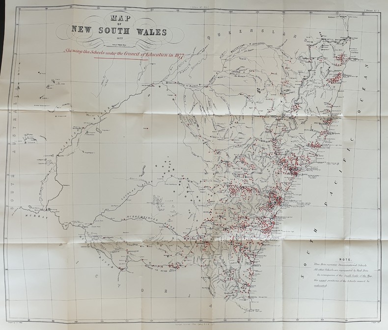
NEW SOUTH WALES
REPORT OF THE COUNCIL OF EDUCATION
Referenz des Buchhändlers : PHO-303
|
|
|
NEW YORK CITY EARLY MAPS
BIRDS EYE VIEW OF NEW YORK AND ENVIRONS - A HAND-COLORED ENGRAVED TOPOGRAPHICAL MAP OF NEW YORK CITY
New York: Kimmel & Foster 1865. 140 x 203 mm. 5 1/2 x 8". Attractively matted. Evidence of previous matting faint brown line at bottom and along right outside the image where earlier mat must have been otherwise fresh clean uncreased and altogther fine. Looking at the island from a southern vantage point this is a fascinating view of Manhattan and environs at the end of the Civil War before the great bridges spanned the river. The surprisingly verdant Battery Park is in the foreground with ships docked at the piers on the tip of the island. The river is swarming with boats from three-masted tall ships to steamships and ferries--and more vessels are docked all around the edges of the island and across the river at the Brooklyn piers. The great bridges that will connect Manhattan with the outer boroughs have yet to be built and the tallest structures in the city are the church steeples. In the far distance uptown we can see the beginnings of Frederick Law Olmstead's Central Park. The density of the buildings and the bustling river traffic establish it as a vital commercial center the seed of what would become the financial capital of the world. Kimmel & Foster unknown
Referenz des Buchhändlers : ST11773b

|
|
|
New York State Planning Council. Advisory Committee on Maps and Surveys.
A state system of plane coordinates / report of the Advisory Committee on Maps and Surveys to the State Planning Council. 1938 Leather Bound
2020. Leather Bound. New. SPECIAL DISCOUNTED PRICE DURING COVID PANDEMIC. Leather Binding on Spine and Corners with Golden Leaf Printing on round Spine. Reprinted in 2020 with the help of original edition published long back 1938. This book is printed in black & white sewing binding for longer life Printed on high quality Paper re-sized as per Current standards professionally processed without changing its contents. As these are old books we processed each page manually and make them readable but in some cases some pages which are blur or missing or black spots. If it is multi volume set then it is only single volume if you wish to order a specific or all the volumes you may contact us. We expect that you will understand our compulsion in these books. We found this book important for the readers who want to know more about our old treasure so we brought it back to the shelves. Hope you will like it and give your comments and suggestions. Lang: - eng Pages 76. EXTRA 10 DAYS APART FROM THE NORMAL SHIPPING PERIOD WILL BE REQUIRED FOR LEATHER BOUND BOOKS. FOLIO EDITION IS ALSO AVAILABLE. hardcover
Referenz des Buchhändlers : LB1111017557507

|
|
|
New York State Planning Council. Advisory Committee on Maps and Surveys.
A state system of plane coordinates / report of the Advisory Committee on Maps and Surveys to the State Planning Council. 1938
2020. Softcover. New. Lang: - eng Pages 76. Reprinted in 2020 with the help of original edition published long back 1938. This book is Printed in black & white sewing binding for longer life with Matt laminated multi-Colour Soft Cover HARDCOVER EDITION IS ALSO AVAILABLE Printed on high quality Paper re-sized as per Current standards professionally processed without changing its contents. As these are old books we processed each page manually and make them readable but in some cases some pages which are blur or missing or black spots. If it is multi volume set then it is only single volume if you wish to order a specific or all the volumes you may contact us. We expect that you will understand our compulsion in these books. We found this book important for the readers who want to know more about our old treasure so we brought it back to the shelves. Any type of Customisation is possible. Hope you will like it and give your comments and suggestions. paperback
Referenz des Buchhändlers : PB1111017557507
|
|
|
New York State Planning Council. Advisory Committee on Maps and Surveys.
A state system of plane coordinates / report of the Advisory Committee on Maps and Surveys to the State Planning Council. 1938 Hardcover
2020. Hardcover. New. Lang: - eng Pages 76. Reprinted in 2020 with the help of original edition published long back 1938. This book is Printed in black & white Hardcover sewing binding for longer life with Matt laminated multi-Colour Dust Cover Printed on high quality Paper re-sized as per Current standards professionally processed without changing its contents. As these are old books we processed each page manually and make them readable but in some cases some pages which are blur or missing or black spots. If it is multi volume set then it is only single volume if you wish to order a specific or all the volumes you may contact us. We expect that you will understand our compulsion in these books. We found this book important for the readers who want to know more about our old treasure so we brought it back to the shelves. Any type of Customisation is possible. Hope you will like it and give your comments and suggestions. hardcover
Referenz des Buchhändlers : 1111017557507
|
|
|
New York State Planning Council. Advisory Committee on Maps and Surveys.
A state system of plane coordinates / report of the Advisory Committee on Maps and Surveys to the State Planning Council. 1938 Full Leather Bound
2020. Full Leather Bound. New. Antique look with Golden Leaf Printing and embossing with round Spine completely handmade bindingextra customization on request like Color Leather Colored book special gold leaf printing etc. Reprinted in 2020 with the help of original edition published long back 1938. This book is printed in black & white sewing binding for longer life Printed on high quality Paper re-sized as per Current standards professionally processed without changing its contents. As these are old books we processed each page manually and make them readable but in some cases some pages which are blur or missing or black spots. If it is multi volume set then it is only single volume if you wish to order a specific or all the volumes you may contact us. We expect that you will understand our compulsion in these books. We found this book important for the readers who want to know more about our old treasure in old look so we brought it back to the shelves. Hope you will like it and give your comments and suggestions. Lang: - eng Pages 76. EXTRA 10 DAYS APART FROM THE NORMAL SHIPPING PERIOD WILL BE REQUIRED. Normal Hardbound Edition is also available on request. hardcover
Referenz des Buchhändlers : SD1111017557507
|
|
|
Nichele, Franc
Cuba
No marks or inscriptions. A lovely clean very tight copy with bright unmarked boards and no bumping to corners. Dust jacket not price clipped or marked or torn or creased with slight traces of storage. 159pp. With a wealth of colour photographs giving the architecture, culture, social life and texture of the island of Cuba..

|
|
|
Nichollls, Margaret W.; Sivertz, Barbara P.
The/A History of Nanoose Bay - Second Edition
196 pages. Index. Two fold-out maps. Many black and white illustrations. Topics include: The First People, Explorers, Pioneers, Nanoose areas, Biographies, The Community. Moderate wear. Unmarked. A sound copy of this substantial work. Book

|
|
|
Nichollls, Margaret W.; Sivertz, Barbara P.
The/A History of Nanoose Bay - Third Edition
204 pages. Index. Two fold-out maps. Many black and white illustrations. Topics include: The First People, Explorers, Pioneers, Nanoose areas, Biographies, The Community, The Next Decade (1980-1990) which provides some coverage of Fairwinds. Gift greetings inside front cover else unmarked. Light wear. A nice copy of this substantial work. Book

|
|
|
Nicholson Maps
London Streetplan Map
Hippocrene Books 1982-06-01. Paperback. Very Good. Item is in very good shape no tears scribbles or underlining a little general wear from a smoke-free environment. Hippocrene Books paperback
Referenz des Buchhändlers : 0609W528598 ISBN : 0092018203 9780092018206

|
|
|
Nicholson Colonel G W L Maps By R W Cole Foreword By Fabian O'Dea Lieutenant Governor of Newfoundland
More Fighting Newfoundlanders: A History of Newfoundland's Fighting Forces in the Second World War Fold-Out Maps Intact WW II / 2 Newfoundland Military / Regiments / Regimental History
Newfoundland: Newfoundland / Labrador: Government of Newfoundland / Labrador 1969 1st Edition First Printing 1969. ----------hardcover close to Near Fine but there are some small splashes/stains to the edges of the text block and the lower edge of the rear board in a lightly rubbed Near Fine dustjacket 621 pages b&w photos contents include: answering the Call; The 57th Heavy Regiment; The 166th Regiment Prepares for Action; The 59th Heavy Regiment on Guard in Britain; Training for Operation OVERLORD; The 166th in North Africa; The 166th on the Lower Adriatic; From Cassino to the Arno; The 59th Regiment Into Battle; From the Leopold Canal to the German Frontier; Winter in the Apennines; Over the Rhine to Victory; No. 125 Newfoundland Squadron RAF R A F Royal Air Force ; The Battle of the Atlantic; Newfoundland Seamen in many Roles; On the Home Front any image directly beside this listing is the actual book and not a generic photo ///NOT SIGNED -GUARANTEED to be AVAILABLE///. First Edition. Hard Cover. Very Good see Description /Near Fine see description. Illus. by Photo Cover. 6.5w x 9.75h Inches. NOT Price Clipped. Newfoundland / Labrador: Government of Newfoundland / Labrador, 1969, 1st Edition, First Printing Hardcover
Referenz des Buchhändlers : 162441

|
|
|
Nickle Maps
Index to the Half Inch Series. Manitoba Saskatchewan Alberta British Columbia
Calgary Alberta ca. 1950: Nickle Maps Map measures 30 by 25 inches unfolded 76 by 64 cm. Maps shows some age toning small tears and creasing. Good. Unbound. Good. BC2-4 Right. Nickle Maps paperback
Referenz des Buchhändlers : 246364

|
|
|
Nicolaus Gurtler (1654-1711).
ORIGINES MUNDI & in eo Regnorum, Rerumpubl. Populorum.
pp. [12], 915, (41) [Index] + Engraved frontis title page (drawn by Joseph Mulder and engraved by Willem de Broen) showing an enormous globe, the author and allegorical figures; Plus + Folding engraved map of the Old World (31 x 42 cm.) - "Orbis Terrarum Veteribus Cogniti Tabula" by Christoph CELLARIUS, showing not only Europe, Africa and Asia, but also Australia; and four woodcut decorated initial letters. Regular title printed in red and black with the Wetstein's engraved whetstone publisher's device. Latin text in roman types, with extensive passages in italic and Greek, and occasional Hebrew and fraktur. 4to. 205 mm. Old damp stain on the first few leaves. The early full leather binding is quite worn. ** The front pastedown bears an early autograph ownership - apparently that of Noel Antoine Pluche (1688-1761), noted French naturalist and writer. Full Title: Nicolai Gurtleri Origines Mundi & in eo Regnorum, Rerumpubl. Populorum; horumque Duces, Migrationes, Dii, Religio, Mores, Instituta, Res gesta, civiles, sacra, bellica. Referuntur omnia ad loca & tempora sua, & ex ipsis fontibus, fereque propriis Historicorum verbis ad modum Historiae Universalis, cum maxime Ecclesiasticae reprasentantur. Cum Indicibus necessariis, iisque locupletissimis. First and only edition of a detailed history of the ancient world, covering and comparing the cultures, religions, governments, (civil and ecclesiastical) legal systems, etc. of societies throughout the Old World. After a brief discussion of the pre-diluvian world, it covers the ancient Middle East, Africa, Asia and Europe country by country or region by region, citing both biblical and classical sources. The Cellarius map appears to be based on the 1664 map of the same title by Johannes Strubius (Shirley 434, in the same projection and showing the same regions, but not including Australia), but its more accurate and up-to-date cartographic data appears to have been taken from one of the world maps in two hemispheres that were common from at least 1658 (Visscher's, Shirley 406). As in those maps, the coast of Australia shows a small break at 30 degrees south latitude. Cellarius (1638-1707) had produced a series of historical maps for his Notitia Orbis Antiqui, first published at Leipzig in 1701, and the present map may be based on one from that book. A detailed ancient history, with an attractive and unusually accurate folding map of the Old World. SCARCE. NCC (5 copies); OCLC WorldCat (7 copies); STCN (1 copy). **PRICE JUST REDUCED! W153
|
|
|
NICOLLE DE LA CROIX Abbé
Géographie moderne
précédé d’un petit traité de la sphère et du globe ornée de traits d’histoire naturelle & politique,d’une géographie sacrée & une géographie ecclésiastique où l’on trouve tous les archevêchés & Evêchés de l’église catholique & les principaux des églises schismatiques Nouvelle édition tome second seul in 12 plein cuir fauve raciné à nerfs,roulette dorée sur nerfs,pièce de titre cuir beige,roulette dorée sur coupes,titre,XVI,648 pages,tranches rouges,8 cartes dépliantes dont Russie Européenne,Turquie Européenne, Afrique, Amérique Septentrionale Amérique Méridionale. Delalain 1812 une tache au coin supérieur gauche du deuxième plat de couverture pâle mouillure partie inférieur de la page 610 à la fin,quelques traces de manipulations table des matières
Referenz des Buchhändlers : 5248
|
|
 Per e-mail erhalten
 Als pdf-Dokument herunterladen
 RSS feed


