|
postcards, postkaarten, wenskaarten
kaartenmolen voor post / wens kaarten van 15cm x10.5cm.
BE-, , 2013 Hoogte molen: minimale hoogte 143cm maximale hoogte 190cm. ,Doorsnede molen: ? 400mm. Vuldiepte: 25mm. volledig nieuw uit voorraad leverbaar.
Référence libraire : 43383
|
|
|
postcards, postkaarten, wenskaarten
kaartenmolen voor post / wens kaarten van 15cm x10.5cm.
Hoogte molen: minimale hoogte 143cm maximale hoogte 190cm. ,Doorsnede molen: ? 400mm. Vuldiepte: 25mm. volledig nieuw uit voorraad leverbaar. 30 Pockets 119mm LIGGEND + 21 Pockets 110mm STAAND. grijs gelakt.

|
|
|
Poste suisse:
10 timbres-poste - Vélo.
Berne, 2017. Feuille de 10 timbres de 1.-, en forme de vélo.
Référence libraire : 23502

|
|
|
Poste suisse:
20 timbres-poste - Hommage aux Selfies.
Berne, 2017. Feuille de 20 timbres de 1.-, effet miroir garanti !
Référence libraire : 23503

|
|
|
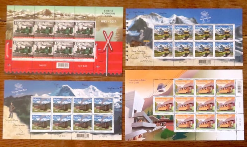
Poste suisse:
4 séries spéciales de timbres-poste - Trains suisses. Brienz Rothorn Bahn - Train de la Schynige Platte - Train de la Wengernalp - Stanserhorn Bahn.
4 feuilles totalisant 34 timbres à 1.-
Référence libraire : 23506
|
|
|
Poste suisse:
6 timbres-poste - Liebe-Amour-Amore-Love.
Berne, 2017. Feuille de 6 timbres de 1.-, en forme de coeur.
Référence libraire : 23501

|
|
|
Poste suisse:
8 timbres-poste - Hornussen.
Feuille de 8 timbres de 1.-
Référence libraire : 23505

|
|
|
Poste suisse:
8 timbres-poste - Schweizer Jass - Jass suisse - Jass svizzero - Jass zwizzer.
Berne, 2025. Feuille de 8 timbres de 1.-
Référence libraire : 23504

|
|
|
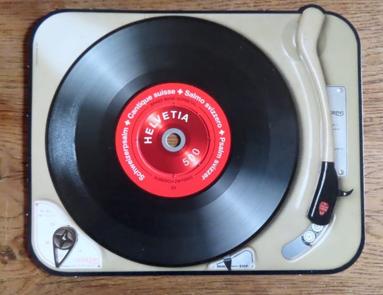
Poste suisse:
Timbre sonore. Schweizerpsalm - Cantique suisse - Salmo svizzero - Psalm sviszzer, Hymne national suisse.
Poste Suisse, 2014. Timbre à la valeur faciale de 5.-, sur un carton au format 17 x 13,5 cm. Très très léger pli à un bord, la rondelle centrale commence à se détacher, en très bon état néanmoins.
Référence libraire : 20821
|
|
|
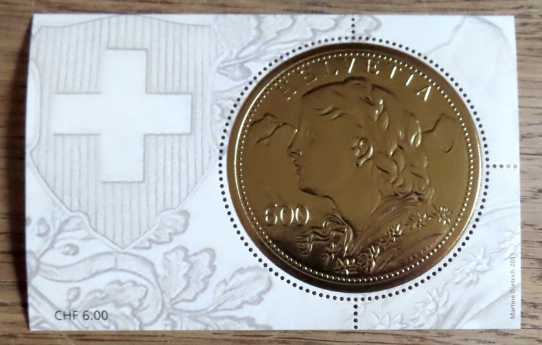
Poste suisse:
«Goldvreneli» – Bloc spécial avec timbres-poste à CHF 6.00.
Poste Suisse, 2014. Timbre circulaire (5,6 cm.), feuille au format 10,7 7 cm. Valeur faciale 6.-
Référence libraire : 20822
|
|
|
Postgate JF. Horrabin maps Wells H. G.; Raymond revision and new material J. F.
The Outline of History Being a Plain History of Life and Mankind - Two Volume Set
US: Garden City Books 1961. Garden City Books 1961 Book Club Edition Very Good/ Complete 2 volume Set. Light bumping to red cloth volume 2 with very good dust jacket Light to moderate wear to red cloth volume 1 with NO DUST JACKET. Light soil to page edges bright pages vol 2 light soil inside covers vol 1 tight bright illustrated pages. Large Heavy Item. Book Club Edition. Hardcover. Very Good. No Exp. Garden City Books Hardcover
Référence libraire : 2000035679
|
|
|
Postkarte/ Ansichtskarte / Künstlerkarte / Carte postale
Adolf Reich, Kunst- und Naturfreund. Nr. 148, München, Haus der Kunst.
Um 1940. 15 x 10,5 cm.
Référence libraire : 3843B

|
|
|
Postkarte/ Ansichtskarte / Künstlerkarte / Carte postale
Arno Breker, "Psyche". Nr. 24, München, Haus der Kunst.
Um 1940. 15 x 10,5 cm.
Référence libraire : 3832B

|
|
|
Postkarte/ Ansichtskarte / Künstlerkarte / Carte postale
Arno Breker, Schreitende. Nr. 36, München, Haus der Kunst.
Um 1940. 15 x 10,5 cm.
Référence libraire : 3845B

|
|
|
Postkarte/ Ansichtskarte / Künstlerkarte / Carte postale
Barbara von Kalckreuth, Träumerei. Nr. 352, München, Haus der Kunst.
Um 1940. 15 x 10,5 cm.
Référence libraire : 3841B

|
|
|
Postkarte/ Ansichtskarte / Künstlerkarte / Carte postale
Ernst Liebermann, Naja an der Quelle. Nr. 408, München, Haus der Kunst.
Um 1940. 15 x 10,5 cm.
Référence libraire : 3840B

|
|
|
Postkarte/ Ansichtskarte / Künstlerkarte / Carte postale
Jacob V. Fehrle, Diana. Nr. 327, München, Haus der Kunst.
Um 1940. 15 x 10,5 cm.
Référence libraire : 3842B

|
|
|
Postkarte/ Ansichtskarte / Künstlerkarte / Carte postale
Jak. Wilh. Fehrle, Tänzerin. Nr. 473, München, Haus der Kunst.
Um 1940. 15 x 10,5 cm.
Référence libraire : 3837B

|
|
|
Postkarte/ Ansichtskarte / Künstlerkarte / Carte postale
Joh Schult, Erwartung. Nr. 507, München, Haus der Kunst.
Um 1940. 15 x 10,5 cm.
Référence libraire : 3835B

|
|
|
Postkarte/ Ansichtskarte / Künstlerkarte / Carte postale
Johann Schult, Im Lebensfrühling. Nr. 411, München, Haus der Kunst.
Um 1940. 15 x 10,5 cm.
Référence libraire : 3839B

|
|
|
Postkarte/ Ansichtskarte / Künstlerkarte / Carte postale
Josef Thorak. Leda mit dem Schwan. München, Haus der Kunst.
Um 1940. 15 x 10,5 cm.
Référence libraire : 3833B

|
|
|
Postkarte/ Ansichtskarte / Künstlerkarte / Carte postale
Konstantin Gerhardinger, Modell-Pause. Nr. 448, München, Haus der Kunst.
Um 1940. 15 x 10,5 cm.
Référence libraire : 3838B

|
|
|
Postkarte/ Ansichtskarte / Künstlerkarte / Carte postale
M. Alfred Brumme, Die Belebende. Nr. 497, München, Haus der Kunst.
Um 1940. 15 x 10,5 cm.
Référence libraire : 3836B

|
|
|
Postkarte/ Ansichtskarte / Künstlerkarte / Carte postale
Prof. Richard Scheibe, Der Morgen. Nr. 58, München, Haus der Kunst.
Um 1940. 15 x 10,5 cm.
Référence libraire : 3844B

|
|
|
Postkarte/ Ansichtskarte / Künstlerkarte / Carte postale
Sepp Hilz, Eitelkeit. München, Haus der Kunst.
Um 1940. 15 x 10,5 cm.
Référence libraire : 3834B

|
|
|
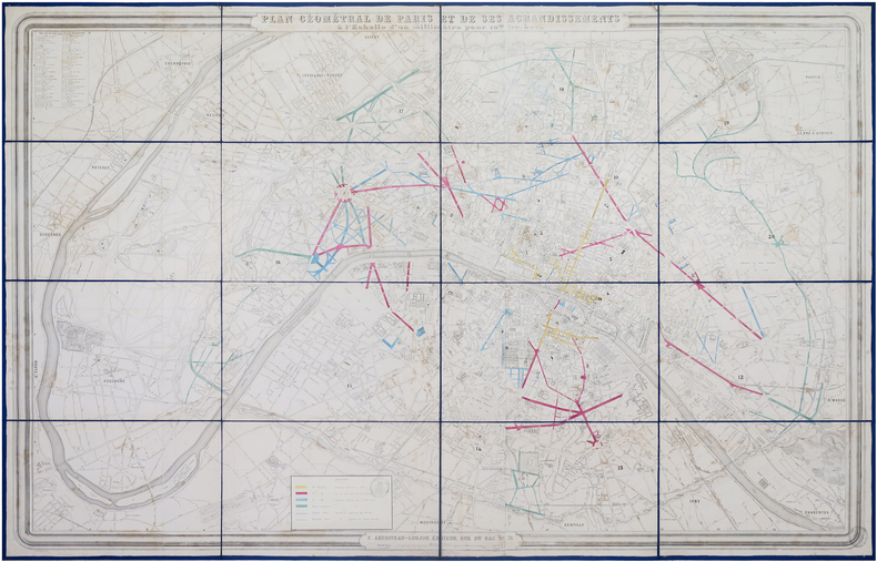
POTIQUET (Alfred) & ANDRIVEAU-GOUJON (Eugène).
Plan géométral de Paris et de ses agrandissements à l'échelle d'un millimètre pour 10 m (10,1 000).
Paris, E. Andriveau-Goujon, 1868. En 16 sections montées sur toile bleu nuit et repliées, formant une carte de 1,03 x 1,53 m ; deux étiquettes au dos avec titres en manuscrit.
Référence libraire : LBW-8041
|
|
|
Potter, Jonathan
Country Life Book of Antique Maps - An Introduction to the History of Maps and How to Appreciate Them
192 pages including bibliography and index. A thorough introduction to the history of antique maps and how to collect and enjoy them, written by one of the world's leading antique map dealers. Wonderfully illustrated in colour. Text divided into three sections: Looking at Maps; Mapping the World and It's Countries; Globes, Curiosities and Miniatures. Book is clean, bright and unmarked with very light wear to reddish boards. Moderate wear to attractive dust jacket which bears two closed tears, each under a half-inch in length, to top edge of back panel. Nice copy. Book
|
|
|
POUQUEVILLE François-Charles-Hugues-Laurent:
Grèce.
Paris, Firmin Didot frères, 1835. In-8 de [4]-447-[1] pages, demi-chagrin rouge, dos lisse orné de fers romantique dorés, tranches marbrées.
Référence libraire : 21047

|
|
|
POUQUEVILLE François-Charles-Hugues-Laurent:
Voyage de la Grèce avec cartes, vues et figures.
Paris, Firmin-Didot, 1826. 6 volumes in-8 de [4]-LXXVIII-[2]-418; [4]-524; [4]-552; [4]-511; [4]-624; [4]-481 pages, demi-basane chamois, dos lisses ornés de fers romantiques. Bel exemplaire non rogné.
Référence libraire : 16419
|
|
|
POURCHER (François).
Carte des chaînes de montagnes de la France, de ses principales rivières, et des principaux canaux de navigation, faits, ou à faire, dans ce royaume.
1782. 435 x 398 mm.
Référence libraire : LBW-5895

|
|
|
Poussart.
CENT PATIENCES OU REUSSITES, LA PLUPART INEDITES.
P., Garnier, 1927. In-12 broché, 208 pages + catalogue. Couv. lég. frottée, Inscriptions en regard de la page de titre, qqs très lég. rousseurs.
Référence libraire : 3382
|
|
|
POWELL MARGIE C.; BUCHT TOM MAPS
Corvallis Trails: Exploring The Heart Of The Valley
Oregon State University Press. Softcover. Brand new book. Situated in the heart of the Willamette Valley and nestled against the rolling hills of the Coast Range Corvallis is an outdoor enthusiast's paradise renowned for its abundance of parks and natural areas easily accessed within a few minutes from downtown. This informative well-organized guide introduces nearly sixty trails all either in Corvallis or within an hour's drive and many suited for casual hikers and families with children. In Corvallis Trails you'll discover close-in recreational opportunities including walks and short hikes in Corvallis city parks and McDonald Forest. Most of these are easily accessible by foot bicycle or public transportation. trails outside of Corvallis but still within easy reach including Marys Peak four National Wildlife Refuges two waterfall walks and nearby Coast Range outings. The detailed trail descriptions include directions maps the length and difficulty of each trail and a wealth of information on the plants wildlife and natural attractions to be found. Also included are accounts of area history and local conservation efforts. Walkers hikers runners mountain bikers equestrians and outdoor enthusiasts of all kinds will find this comprehensive guidebook an essential companion as they explore the miles of well-known - and not so well-known - trails in Corvallis and environs. Oregon State University Press paperback
Référence libraire : 78116X2
|
|
|
Powell, J. W
TWELFTH ANNUAL REPORT OF THE UNITED STATES GEOLOGICAL SURVEY TO THE SECRETARY OF THE INTERIOR 1890-'91. Part 1 - GEOLOGY.
Washington, Government Printing Office, 1891. 4°. With many plates, illustrations and maps, 6 folding pocket maps. 675 pp. Original gold stamped cloth. Mit zahlreichen Tafeln, Textabbildungen und Karten, 6 Faltkarten in Anhangtasche. Orig.-Leinen mit Deckelvergoldung, Rückengoldprägung. - Content: The origin and nature of soils; The lafayette formation; The north american continent during cambrian time; The eruptive rocks of electric peak and sepulchre mountain, yellowstone national park etc. Binding scratched. Einband berieben.
Référence libraire : 5664

|
|
|
Pratt Fletcher. Maps By Rafael Palacios
The Third King
New York: William Sloane Associates Inc. 1950. First edition stated first printing 1950. Biography of King Valdemar of Denmark. Dark turquoise cloth with color illustrated dustjacket. Some edgewear good hinges sound text block age-toned endpapers pages clean and free from names or other markings. The mylar protected dustjacket is not priceclipped and has some minor edge chipping mainly to the spine ends little paper loss. First Edition. Hard Cover. Good/Good. 12mo - over 6�" - 7�" tall. William Sloane Associates, Inc. Hardcover
Référence libraire : 029341

|
|
|
Pratt Waldo Selden & Maps Drawings
The History of Music A Handbook & Guide for Students
SCHIRMER Books. Good with no dust jacket. 1924. Hardcover. Corners bumped name inscription inside cover. No text marks very clean copy. . SCHIRMER Books hardcover
Référence libraire : 146435

|
|
|
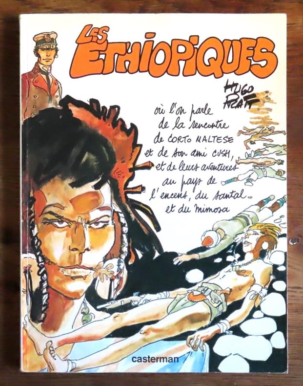
Pratt Hugo:
Corto Maltese - Les Ethiopiques.
Casterman, 1979. In-4 broché, couverture couleurs, très légèrement défraîchie.
Référence libraire : 19798
|
|
|
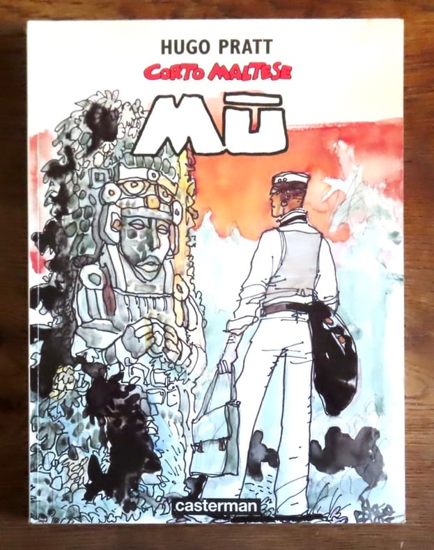
Pratt Hugo:
Corto Maltese - Mû.
Casterman, 1979. In-4 broché, couverture couleurs, très légèrement défraîchie (plis de lecture au dos).
Référence libraire : 19799
|
|
|
Pratt Hugo:
Corto Maltese. La cour secrète des Arcanes. . . en 36 cartes.
Christian Desbois. Jeu de 36 cartes au format 7,5 x 12 cm, feuillet dépliant illustré, sous boîte couleurs. Frottements en bords de la boîte.
Référence libraire : 23076

|
|
|
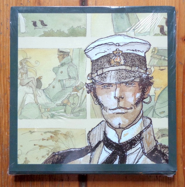
Pratt Hugo:
Les Celtiques.
Casterman, 1996. 6 cartes doubles avec enveloppes, sous pochette illustrée. A l'état de neuf, sous emballage d'origine.
Référence libraire : 6240
|
|
|
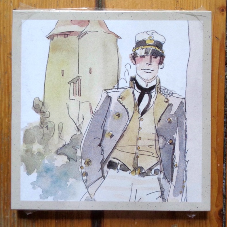
Pratt Hugo:
Les Helvétiques.
Casterman, 1997. 6 cartes doubles avec enveloppes, sous pochette illustrée. A l'état de neuf, sous emballage d'origine.
Référence libraire : 6239
|
|
|
PRE WWII MAPS OF JAVA.
Map of Java in 3 sections. Kaart van Java in 3 deelen met Afstandstabellen en enkele gegevens.
Batavia.: Travellers Official Information Bureau of the Netherlands Indies. No date 1937. Complete set of three maps of Java backed onto linen. Maps measure 31 x 45cm. Scale 1:1000000. Each map coloured in pink apparently by a prior owner and some places underlined in blue pencil. Ink blot on margin of Oost-Java map one map a little damp damaged but not offensively so. Some general wear and markings. Original card case and tables of distances missing. A useful working set. In Dutch and English. The three maps in this collection: West Java; Middle Java and East Java show main roads other motor roads cart tracks ferry routes air routes and landing fields railways rest houses and hotels perfect for tourists visiting Java in the late 1930s. . Travellers Official Information Bureau of the Netherlands Indies. unknown
Référence libraire : 162234

|
|
|
PRE WWII MAPS OF JAVA.
Map of Java in 3 sections. Kaart van Java in 3 deelen met Afstandstabellen en enkele gegevens.
Batavia.: Travellers Official Information Bureau of the Netherlands Indies. No date 1937. Complete set of three maps of Java backed onto linen with presented in the original card slipcase. Maps measure 31 x 45cm. Scale 1:1000000. 4 folding sheets with tables showing distances loosely inserted presented in the original card slipcase. Slipcase torn with a little loss and a little damp damaged in places. Signature of a prior owner dated 1941 slipcase. A nice set. In Dutch and English. The three maps in this collection: West Java; Middle Java and East Java show main roads other motor roads cart tracks ferry routes air routes and landing fields railways rest houses and hotels perfect for tourists visiting Java in the late 1930s. . Travellers Official Information Bureau of the Netherlands Indies. unknown
Référence libraire : 162235

|
|
|
Prentice, Robin (editor)
The National Trust for Scotland Guide
No marks or inscriptions. A very clean very tight copy with bright unmarked boards and no bumping to corners. Dust jacket not price clipped or marked or torn with sunned spine and a little creasing to edges. 320pp. A comprehensive reference to the National Trust's houses, castles, gardens, islands, historic sites and the people associated with them.

|
|
|
Prep. by GILBERT R. MARTINEAU.
Les guides Nagel. Finlande. Preface de Jean-Paul Sartre.
Very Good English Paperback. Pbo. 12mo. (16 x 10 cm). In French. [xv], 184 p. Color maps. Les guides Nagel. Finlande. Preface de Jean-Paul Sartre.
|
|
|
Prep. by OSMAN NURI ERGIN, (1883-1961).
[EARLY ISTANBUL CITY GUIDE OF THE REPUBLIC PERIOD] Istanbul sehri rehberi 1934.
Fine Turkish Original grey cloth bdg. Cr. 8vo. (20,5 x 11,5 cm). In Turkish. 240 p., texts and many folding color plans (additionally in end-pockets). First Edition. Maps are complete, scarce. Osman Nuri Ergin was the initiator of the studies regarding modern municipalities' studies and gave so many qualified books related to Ottoman-Turkish urbanism and municipalities' studies scientifically. He was also the first scholar who was one of the architectures of municipalities' studies and the history of urbanism and education. Since he worked as an officer for the government during World War I, the time of Abdulhamid II, and at the time of the young Republic, he was one of the figures who know the cultural and social changes in Turkish society. During this cultural transformation, he played the role of a bridge between Ottoman culture and modern-day Turkey with the help of some enlightened scholars. He had so many attempts to transform the Ottoman Sufi culture into the next generations. To reach this goal, he wrote so many valuable books. OCLC 216699691.
|
|
|
President: H. E. SIR MILES LAMPSON, (1880-1964).
[RARE DESERT MOTOR-ROUTES FOR THE ANGLO-EGYPTIAN MOTORISTS] Egyptian Touring Association handbook 1939-40. Member of Alliance Internationale de Tourisme; federated with the Automobile Association of Great Britain. Preface by Sir Stenson Cooke.
Very Good English Original green cloth. Title gilt in black "Egyptian Touring Association" and "ETA logo" to the front board. Foolscap 8vo. (17,5 x 13 cm). In English. 110 p. with rich separate advertisements, and a fine folded b/w map titled "Desert motor-routes" on a scale of 1:4,000,000. Slightly fading on cloth, otherwise a fine copy. First and only edition of this rare complete and very detailed desert motor-routes' guide for the Anglo-Egyptian motorists, printed by the Egyptian Touring Association in Cairo, including details about hospitals, "what to do in cases of accidents on the roads", free legal defence, hotels, garages as well as itineraries, pedestrian crossings, speed limits in the country, parking regulations of Sharia Kasr el Nil, Adly Pasha, no-lights area, railway bridges, postal rates, exchange rates, rates of freight on motor cars by sea and rail, kilometers into miles, transcontinental road London - Istanbul with other useful information. This guide was explained in the introduction as "This handbook has been compiled for the benefit of members and is issued to them free. Extra copies may be obtained from the Head Office, 3 Sh. Cattawi Bey, Kasr el Nil, Cairo, at the price of P.T. 10. It contains a good deal of useful information regarding touring of all kinds in Egypt and abroad including a list of recommended hotels and garages throughout the country. "The president of the Association which was founded in 1932, was H.E. Sir Miles Lampson (1880-1964). He was a British diplomat who was appointed High Commissioner for Egypt and Sudan in 1934. As a result of the Anglo-Egyptian Treaty in December 1936, to which Lampson was a signatory, Britain loosened its grip on Egypt and the post title was changed to Ambassador to Egypt and High Commissioner for Sudan in 1936. Lampson continued in this office until 1946. Vice presidents were Sir Stenson Cooke and J. A. Crawford. According to the ETA's service page of the guide, the purpose of the association can be determined as "Association was formed to provide a long-felt want in Egypt, that is, a touring club in the true sense of the word, devoted to the interests of all kinds of travelers. It's a non-profit making co-operative organization with the aim of making the path of the motorist, the airman, the camper, and every other kind of traveler pleasanter and smoother. The E.T.A. is officially recognized by the Egyptian Government and already in its short existence has grown enormously, being able to offer the following very real services to its members: Expert and detailed advice on all touring matters. Expert advice on motoring matters and vetting of cars. Free itineraries to all parts of Egypt and abroad. Reminders are sent to all members when a car and driving license is due for renewal. Renewal of car and driving licenses. Free legal defense for motoring offenses. Triptyques, carnets, and all documents for foreign touring, including passport arrangements. Agents at Alexandria, PortSaid, Suez, and the principal ports to look after the incoming and outgoing motorist and relieve him of all worry. A full stock of maps and guide books of Egypt and other countries. Up-to-date information on the state of roads and desert tracks. Welcome and help from the 100 odd touring clubs of the A.I.T. [i.e. the Alliance Internationale de Tourisme], of which the E.T.A. is a member. Recommended hotels and garages throughout Egypt and the Near East. Insurance for members can be effected at the most advantageous rates, and advice is given. Cars can be driven to any part of Egypt, by experienced drivers. Guides are provided. Other benefits, it is hoped, will be given in due of course.". Not located in OCLC. "1938-39 Edition" of the series (not published more than two years) is located in OCLC in no. 862336537.
|
|
|
Press Waterford; National Geographic Maps; Press Waterford Compiler
Belize Adventure Set: Map & Naturalist Guide
Waterford Press 2015-04-14. Wall Chart. Used:Good. Waterford Press unknown
Référence libraire : DADAX1583559221 ISBN : 1583559221 9781583559222

|
|
|
Press Waterford; National Geographic Maps; Press Waterford Compiler
Galapagos Islands Adventure Set: Map & Naturalist Guide
Waterford Press 2015-04-14. Paperback. Used:Good. Waterford Press paperback
Référence libraire : DADAX1583559094 ISBN : 1583559094 9781583559093

|
|
|
Press Waterford; National Geographic Maps; Press Waterford Compiler
Zion National Park Adventure Set: Map & Naturalist Guide
Waterford Press 2015-04-14. Map. Used:Good. Waterford Press unknown
Référence libraire : DADAX1583559205 ISBN : 1583559205 9781583559208

|
|
|
PRESTIDIGITATION.
LE RIRE PARISIEN .
1900 1900 Fabrique d ' Appareils de Prestidigitation et d ' Illusion . CATALOGUE GENERAL environ 1930 ?. couverture orange illustrée. plaquette in 8 . 175 pp + table des matières. abondamment illustré in texte. Exemplaire très propre.
Référence libraire : 494QUA

|
|
 Recevoir par e-mail
 Télécharger en PDF
 Flux RSS


