|
Ruth Kent maps: MacLean Robert
TOURING THE OLD WEST
Brattleboro VT: Stephen Greene Press. VG/G. 1971. . Cloth. 8vo. 218 pp. DJ chipped . Stephen Greene Press hardcover
Referência livreiro : BOOKS18161 ISBN : 0828901295 9780828901291
|
|
|
Ruth H. McCuaig (Signed)
Our Pointe Au Baril
Signed and inscribed by author atop first blank leaf. xii, 322 pages. Bibliography. Index. Generously illustrated with black and white reproductions of archival photos. Presents the history of this community on the eastern shore of Georgian Bay in the Parry Sound District. Chapters include: The French; The Fur Trade; The Cartographers; Nineteenth Century Transients; The Loggers; The Fishermen; The Hotels; The Summer People; Pointe au Baril Station; The Islanders' Association; The Arts; and more. Average wear. Binding intact. A sound copy of this informative local history. Book

|
|
|
Région de Lyon.
Carte géologique détaillée de la France. Lyon N° 168.
1890 carte toilée 61 x 112 cms, texte entourant la carte, en couleurs. P. Baudry 1890,
Referência livreiro : 7703
|
|
|
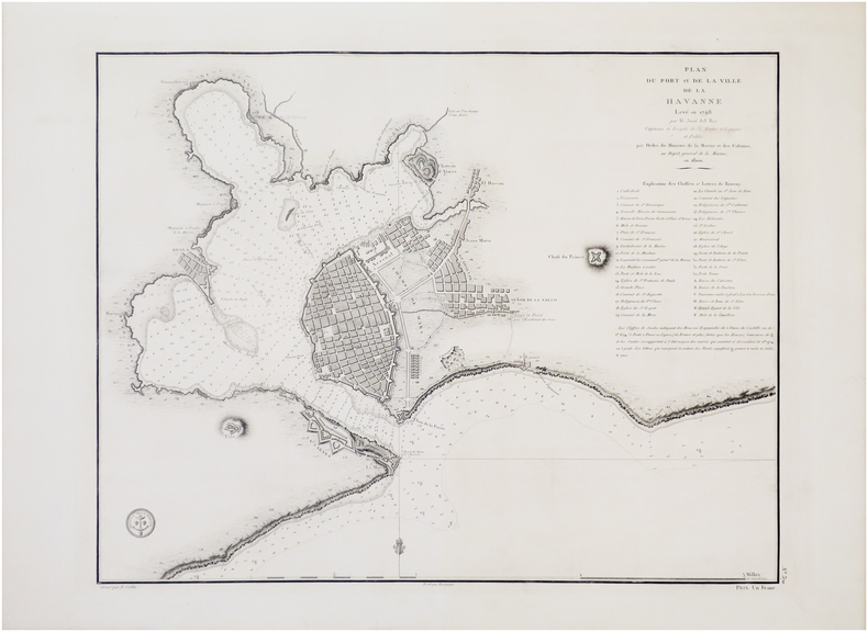
RÍO de LA COSA (José del).
[CUBA] Plan du port et de la ville de La Havanne levé en 1798 par D. José del Rio.
[Paris], Dépôt Général de la Marine, 1800. 415 x 530 mm.
Referência livreiro : LBW-7679
|
|
|
Röder, Franz; Röder, Karl [Hrsg.]
Der Kriegszug Napoleons gegen Rußland im Jahr 1812. Nach den besten Quellen und seinen eignen Tagebüchern dargestellt nach der Zeitfolge der Begebenheiten von Franz Röder. Nach des Verfassers Tode herausgegeben von dessen Sohn Karl Röder.
Leipzig, Verlag von Wilhelm Engelmann, 1848. 8°. 21 cm. XXX, 567 Seiten, X Blatt. Pappband der Zeit, gebunden. Mit goldgeprägtem Rückentitel.
Referência livreiro : 6469DB

|
|
|
S P Maps
Chester and Ellesmere Port Street Plan and Guide
Shoreham-on-Sea: Service Publications 1994. Book. Very Good. Map. 9th edition. Folded map in very good condition card cover has light shelfwear. Undated but probably 1994 =/- a year. Service Publications Paperback
Referência livreiro : 19110812-205 ISBN : 1852821124 9781852821128

|
|
|
S P Maps
Ludlow Leominster Church Stretton Tenbury Wells . Street Plan and Guide
Shoreham-on-Sea: Service Publications 1999. Book. Very Good. Map. 1st Edition. Folded map in very good condition card cover has light shelfwear. Service Publications Paperback
Referência livreiro : 19110810-205 ISBN : 1852823100 9781852823108

|
|
|
S P Maps
York Street Plan and Guide
Shoreham-on-Sea: Service Publications 1998. Book. Good. Map. 12th ed. Folded map generally in very good condition card cover has shelfwear front cover has a crease. Service Publications Paperback
Referência livreiro : 19110811-205 ISBN : 1852823089 9781852823085

|
|
|
S P Maps Service Publications
Grantham Stamford Sleaford & Bourne: Street Plan and Guide
Shoreham-by-Sea: Service Publications Ltd. Covers creased contents very good. . Good. Paperback. 9th Edition. 1999. Service Publications Ltd paperback
Referência livreiro : 148885 ISBN : 1852821590 9781852821593
|
|
|
s. l.d. d'Annemie Buffels. Avec une introduction de Willem Elias
Art du jeu, 75 ans de Loterie Nationale
Bruxelles, Fonds Mercator/ Mercatorfonds , 2009 Hardback, 280x240mm, 224p, French ( FR ) edition ISBN 978906153912413.
Referência livreiro : 24404
|
|
|
s. l.d. d'Annemie Buffels. Avec une introduction de Willem Elias
Kunst van het Spel , 75 jaar Nationale Loterij
Bruxelles, Fonds Mercator/ Mercatorfonds , 2009 Hardback, 280x240mm, 224p, Dutch (NL) edition ISBN 978906153911713.
Referência livreiro : 23416
|
|
|
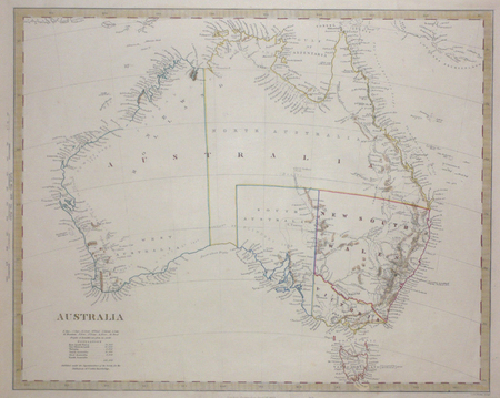
S.D.U.K.;
[AUSTRALIE] Australia.
Londres Society for the Diffusion of Useful Knowledge 1853 317 x 395 mm.
Referência livreiro : LBW0072b
|
|
|
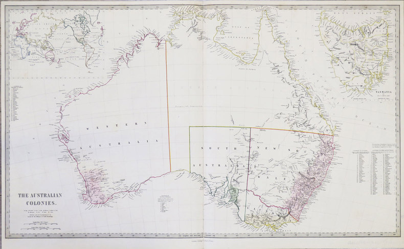
S.D.U.K.
[AUSTRALIE] The Australian colonies.
London, George Cox, 1853. 405 x 684 mm.
Referência livreiro : LBW-855
|
|
|
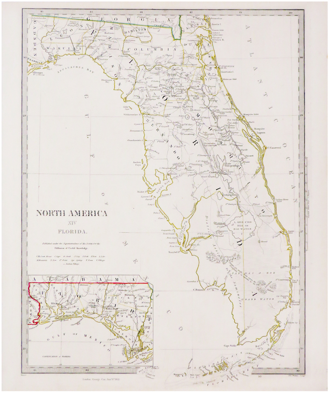
S.D.U.K.
[FLORIDE] North America XIV Florida.
London, George Cox, 1852. 410 x 312 mm.
Referência livreiro : LBW-3494
|
|
|
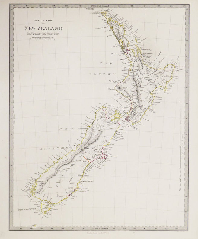
S.D.U.K.
[NOUVELLE-ZÉLANDE] The Islands of New Zealand.
London, George Cox, 1853. 400 x 310 mm.
Referência livreiro : LBW-3418
|
|
|
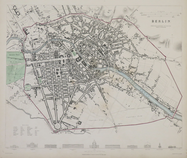
S.D.U.K.
Berlin.
Londres, Baldwin & Cradock, 1833. 310 x 365 mm.
Referência livreiro : LBW-4317
|
|
|
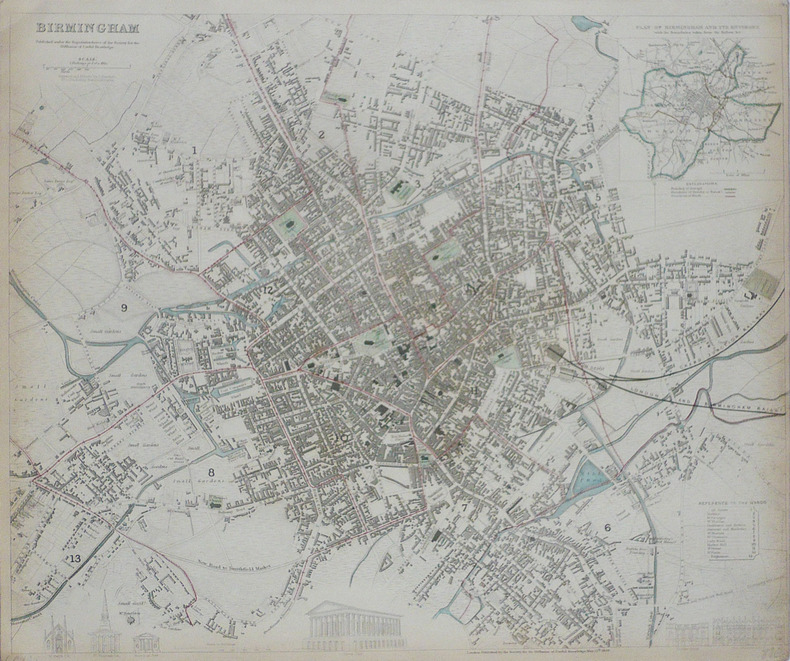
S.D.U.K.;
Birmingham.
Londres Society for the Diffusion of Useful Knowledge 1839 332 x 403 mm.
Referência livreiro : LBW-1767
|
|
|
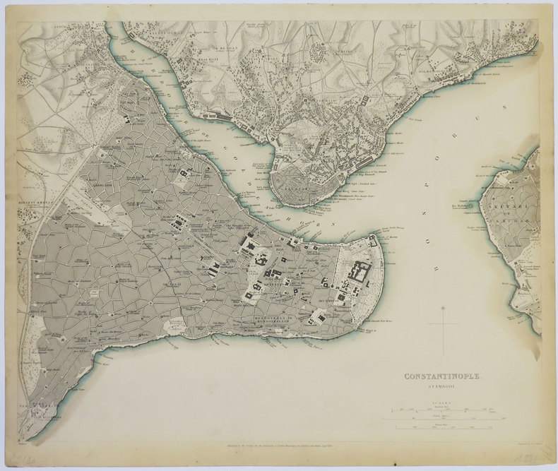
S.D.U.K.
Constantinople. Stambool.
Londres, 1840. 320 x 391 mm.
Referência livreiro : LBW-3552
|
|
|
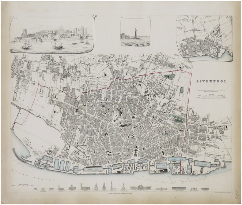
S.D.U.K.
Liverpool reduced by permission from Mr. Gage's elaborate survey.
Londres, Baldwin & Cradock, 1836. 380 x 385 mm.
Referência livreiro : LBW-1765
|
|
|
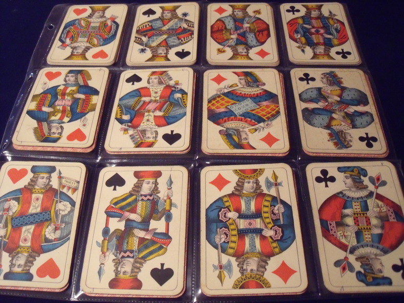
S.D.MODIANO ://:
WIENER BILD.
Wiener Bild.Portrait Viennois. Jeu Des Couronnes.Kaffée Haus KARTEN.(cartes des maisons de café.)type A. 52cartes.complet.1906.Fabricant:SD.ModianoTriest.Italie.Trés bon état .Sans boite.
Referência livreiro : 0631906
|
|
|
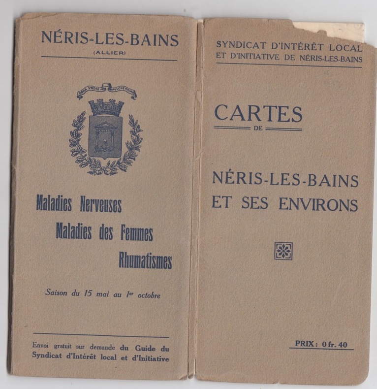
S.I.- Neris les bains
Cartes de Neris les bains et ses environs
S.I.- Neris les bains, grandes cartes dépliantes,texte au dos,rare
Referência livreiro : 25585
|
|
|
Saalfeld:
Saalfeld. "Plan des Marches einiger Königl. Preussischen Trouppen nach Salfeld und der dabey vorgefallenen Gefangennehmung zweyer Bataillons der combinirten Reichs-Armee, d. 2. April 1761". Schlachtenplan von Saalfeld. Kupferstich mit farbigen Truppenaufstellungen aus "Neues Kriegs-Theater ...", No. 38.
Format: 18 x 29,5 cm. *Leicht gebräunt, insgesamt gut erhalten. Landkarten de
|
|
|
SAARBRUCKEN
Carte d'Etat-Major au 1/200 000?. Fin XIXe.
1 feuille repli?e. 32x49 cm.
|
|
|
Sack Manfred
Playgirls d'Antan
Duculot In-12°, 171 pages, bel ouvrage orné de 77 clichés à pleine page au format carte postale en noir et en couleurs.
Referência livreiro : 9183
|
|
|
Saccone, Richard
Travel Korea Your Way
213 pages including index. Describes over 60 of the most popular attractions Korea has to offer. Includes over 160 spectacular color photos and 20 informative maps. Provides everything you need to plan a wonderful vacation in Korea. Price clipped from flap of back cover. Minimal traces of wear. Tiny rubber date stamp upon bottom edge of textblock. Book
|
|
|
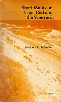
Sadlier Paul & Ruth; photos & maps by the authors Illustrator
SHORT WALKS ON CAPE COD AND THE VINEYARD Paperback Jan 01 1976 Sadlier .
The Pequot Press 1976-01-01. Paperback. Very Good. Prompt reliable service mailed next business dayThe Pequot Press 1975 stated first edition paperback signed by both authors on half-title fine wrapper smooth spine tight binding clean unmarked text Prompt reliable service shipped next business day. Int'l mailed via first class or priority. The Pequot Press paperback
Referência livreiro : SpNF122159
|
|
|
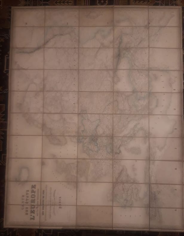
Sagansan.
Carte des Etats de l'Europe avec les régions circonvoisines, indiquant les chemins de fer, les principales routes et les subdivisions des états, dressée d'après les documents officiels les plus récents.
1868 1 160 cm x 120cms Carte Entoilée indiquant les chemins de fer, les principales routes et les subdivisions des états, dressée d'après les documents officiels les plus récents.Géographie gravée par Blondeau et écritures par Rousset.
Referência livreiro : LCI-4059
|
|
|
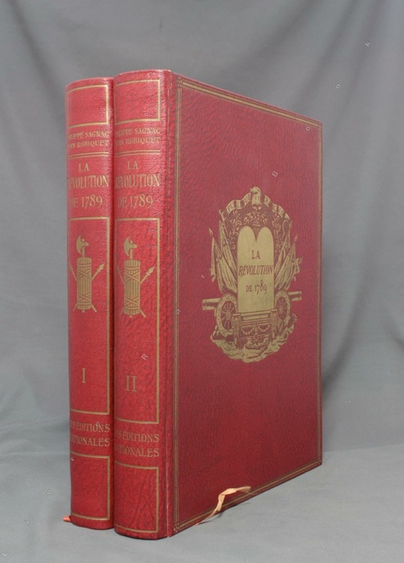
SAGNAC Philippe:
La Révolution de 1789.
A Paris, Les Ed. nationales, 1934. 2 volumes in-4 de XV-390-[6] + 412-[12] pages, reliure d’éditeur percailne rouge, dos lisses ornés, plats ornés d’un médaillon doré en leur centre et encadré de 3 filets dorés, couvertures conservées.
Referência livreiro : 1643
|
|
|
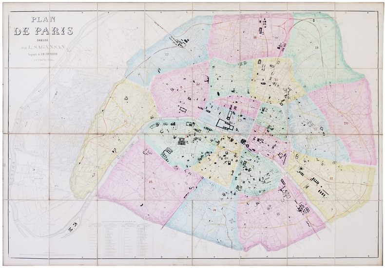
SAGANSAN (L.).
Plan de Paris.
1866. En 32 sections montées sur toile et pliées, formant une carte de 0,80 x 1,14 m ; étiquette de l'éditeur Lanée au dos de la carte ; sous étui de papier marbré.
Referência livreiro : LBW-5780
|
|
|
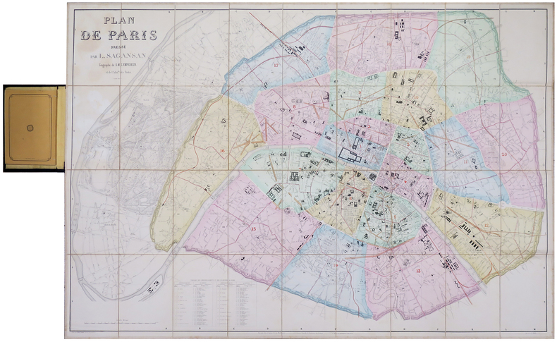
SAGANSAN (L.).
Plan de Paris.
Paris, chez l'auteur, 1860. En 36 sections montées sur toile et pliées, formant un plan de 0,79 x 1,14 m ; monté dans sa reliure éditeur en percaline noire (20,5 x 13 cm), contenant une nomenclature des rues de 104 pages ; titre en lettres dorées sur le premier plat.
Referência livreiro : LBW-6199
|
|
|
Sagebrush Maps; Rand McNally
Eugene Springfield Oregon: Street Atlas
Sagebrush Maps 2001-01. Spiral-bound. Good. Sagebrush Maps unknown
Referência livreiro : SONG0929591674 ISBN : 0929591674 9780929591674

|
|
|
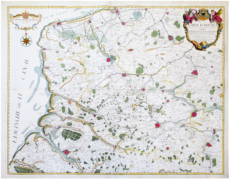
SAINT-ALEXIS (Constantin de).
[ARTOIS] Carte d’Artois dressée sur de nouveaux mémoires.
Arras, Barbier, 1741. En quatre feuilles jointes formant une carte de 97,3 x 119,6 cm.
Referência livreiro : LBW-6681
|
|
|
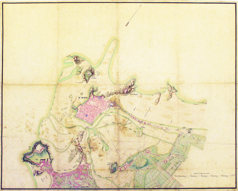
SAINT-MALO. MANUSCRIT.
[Plan de Saint-Malo et de Saint-Servan].
[circa 1830]. 870 x 720 mm, sur papier vélin.
Referência livreiro : LBW-4189
|
|
|
SAINTE-CROIX par Ernest-Louis PAILLARD.
Les vallons de Sainte-Croix et des Granges de Sainte-Croix, dans le Haut Jura vaudois. Etude de géographie avec 22 cartes, dessins et graphiques dans le texte.
Ntel, société neuchâteloise de géographie 1943. Bel ex. broché, couv. D'orig. Gd in-8, 152 p. pour cette étude avec introductions, illustrations et sources.
Referência livreiro : AUB-7920
|
|
|
SAINT-GERMAIN.-
Maître Pierre, ou le Savant de village. Géographie de la France.
Paris, Chez F.G. Levrault, 1834, in-12°, 216 p. + 3 cartes dépliantes, envois ms à la première page + stempel 'Hospice du Simplon', en page de titre. cartonnage originale illustrée. Bel exemplaire.
Referência livreiro : 50921aaf
|
|
|
SAINT-OMER. MANUSCRIT.
Plan de S.t Omer.
[circa 1710]. En 2 feuilles jointes de 510 x 715 mm.
Referência livreiro : LBW-4193

|
|
|
SAINT-OMER. MANUSCRIT.
Plan de St Omer.
[circa 1750]. En 2 feuilles jointes de 435 x 600 mm, sur papier fin huilé.
Referência livreiro : LBW-4194

|
|
|
SAINT-JEAN-de-LUZ. MANUSCRIT.
Plan de St. Jean de Luz avec les projets d'aggrandissement du port.
[circa 1782]. 510 x 660 mm.
Referência livreiro : LBW-4179

|
|
|
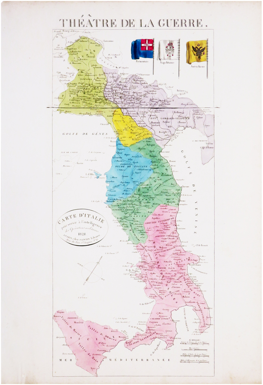
SAINTIN (Claude-Auguste).
Théâtre de la guerre. Carte d'Italie pour servir à l'intelligence des opérations militaires.
Paris, Saintin, 1821. 535 x 241 mm.
Referência livreiro : LBW-8033
|
|
|
SAIT TALÂT (Büyük Erkâniharbiye IX. Sube Md. Deniz Kaymakami).
En eski Amerikan haritasi.
Very Good Turkish Modern cloth. Roy. 8vo. (24 x 17 cm). In Turkish. 16, [1] p., b/w ills. En eski Amerikan haritasi.
|
|
|
Sakellarakis, JA
Herakleion Museum
Previous owner's name on ffep. No other inscriptions or marks. No creasing to covers or to spine. A very clean crisp tight copy with bright unmarked boards and no bumping to corners. 144pp. Comes with a tucked-in map of Crete and details of public bus service.

|
|
|
Sakkas George K.
Crete in Colour : A Tourist Guide Book.
Athens: Artemis Pub 1972 Short interesting guide book to Crete. Pbk. 120p. plates some col. maps of Crete and street map of Iraklion. Very Good. Artemis Pub unknown
Referência livreiro : 14736
|
|
|
Sakkas George K.
Crete in Colour : A Tourist Guide Book.
Athens: Artemis Pub 1972 Short interesting guide book to Crete. Pbk. 120p. plates some col. maps of Crete and street map of Iraklion Condition : Good. Very Good. Artemis Pub unknown
Referência livreiro : 14737
|
|
|
Sakkas George K.
Crete in Colour : A Tourist Guide Book.
Athens: Artemis Pub 1972 Short interesting guide book to Crete. Pbk. 120p. plates some col. maps of Crete and street map of Iraklion. Very Good. Artemis Pub unknown
Referência livreiro : 14735
|
|
|
Sakkas,George K.
Crete in Colour : A Tourist Guide Book.
Short interesting guide book to Crete. 120p. plates (some col.) maps of Crete and street map of Iraklion. Vintage copyY) Book
|
|
|
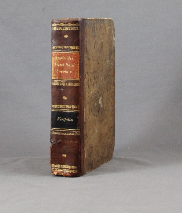
SALMON Thomas:
Lo stato presente du tutti i paesi, e popoli del mondo naturale, politico, e morale, con nuove osservazioni, e correzioni degli antichi, e moderni viaggiatori. Volume X. Dei circoli susseguenti dell'Imperio, cioe' Svevia, alto, e basso Reno, e Vestfalia e delle dieci provincie dei Paesi Bassi austriaci, e francesi.
Venezia, Giambatista Albrizzi, 1740. In-8 de [12]-502-[2]p. demi-basane brune, dos lisse, filets et fleurons dorés, pièces de titre et tomaison noir et orange (un mors fendu tristement recollé, coins tapés, rousseurs, annotations).
Referência livreiro : 6334
|
|
|
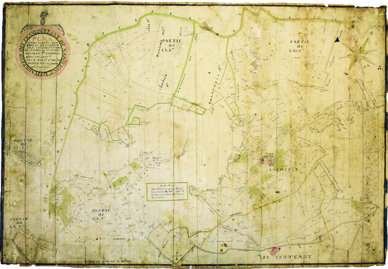
SALEON DUCLO (Jean-François). MANUSCRIT.
Plan d'une partie des biens de monsieur Jala Louis Allexandre de Lachieze, commune de Pranles comprise dans les sectons levé par Jn Fois Saléon Duclo géomètre du cadastre de la ville de Cheylard.
1812. 560 x 825 mm.
Referência livreiro : LBW-4182
|
|
|
Sale, Richard ; Rudd, Peter
The Visitor's Guide to the Italian Lakes
No marks or inscriptions to contents. A very clean very tight copy with bright unmarked red cloth boards, discolouration to small part of upper rear corner and no bumping to corners. Dust jacket price clipped but not marked or torn or creased with general traces of storage. 256pp. Detailed guide to the Italian Lakes - Orta, Maggiore, Lugano, Como and Garda and the surrounding area. Well illustrated.

|
|
|
Salvador, I.
Geschichte der RÖmerherrschaft in JudÄa und der ZerstÖrung Jerusalems [Vol. 2 ONLY]
[Vol.2 ONLY]. 8' 483pp. glit hardcover. cover slightly worn. ex library with usual words. a few pencil marks on inner cover. some aging marks on pages. a couple of maps added. else in fair condition.
|
|
|
Samson, Pet. Heinr. [Peter Heinrich]
Die Entwickelung der Freien und Hansestadt Hamburg von der Entstehung bis auf die Gegenwart in geschichtl. Grundzügen, Sagen u. Biographien, nach den Quellen chronologisch geordnet.
Hamburg, Carl Pottier, 1886. VIII, 119 S. Mit 1 gefalt. farb. lithograph. Straßenplan. HLn. d. Zt.
Referência livreiro : 17370

|
|
 Receber por correio electrónico
 Descarregar em documento PDF
 Fluxo RSS


