|
|
|
ZAHN Johann (1631-1707)
Tabula Geographico-Hydrographica Motus Oceani Currentes, Abyssos, Montes Ignivomos in Universo Orbe…
Carta nautica del mondo tratta dalla Specula physico-mathematico-historica notabilium ac mirabilium sciendorum, in qua mundi mirabilis oeconomia ... nunc autem ad lucem protractus, ac ad varias perfacili methodo acquirendas scientias in epitomen collectus thesaurus curiosis omnibus cosmosophis inspectandus proponitur... / authore Joanne Zahndello Zahn, una cosmografia riccamente illustrata. Zahn era un monaco, studioso e scienziato, si dedicò a studi sulla camera oscura. La sua opera è sulla scia di Athanasius Kircher - studioso gesuita, uno dei primi scrittori sui fenomeni fisici della terra - che, nel suo Mundus Subterraneus (1665) teorizzava che tutti gli oceani della Terra erano connessi tra loro tramite dei tunnel sotterranei che univano oceani e mari. Tra il Mar Mediterraneo, il Mar Nero, il Mar Caspio e il Golfo Persico, Kircher ha teorizzato enormi gallerie e un complesso interscambio di flussi d'acqua. Questi tunnel sono particolarmente noti tra il Mar Nero e il Mar Caspio e tra il Mediterraneo e il Golfo Persico. L'Antartide è rappresentata lungo la parte meridionale della mappa. A nord è raffigurato un grande passaggio aperto a nord-ovest che corre lungo tutta la mappa. Mostra la Nuova Guinea e una suggestione dell'Australia collegata alla terraferma Australsis Incognita. L'Africa è mostrata con una precisione notevolmente maggiore rispetto a molte mappe disegnate centinaia di anni dopo - in particolare per quanto riguarda il Niger e i sistemi fluviali del Nilo. Il Nord America e il Sud America sono entrambi maldestramente raffigurati, il che indica una conoscenza relativamente sommaria del continente. La Corea viene mostrata come un'isola e il Giappone appare come un'unica isola. Incisione in rame, in ottimo stato di conservazione. A world chart from the Specula physico-mathematico-historica notabilium ac mirabilium sciendorum, in qua mundi mirabilis oeconomia ... nunc autem ad lucem protractus, ac ad varias perfacili methodo acquirendas scientias in epitomen collectus thesaurus curiosis omnibus cosmosophis inspectandus proponitur... / authore Joanne Zahn, a finely illustrated cosmography, designed to show the ocean currents, vortexes and volcanos. Johann Zahn (1631-1707), a German monk, also published a … read morebook on optics, 'Oculus Artificialis Teledioptricus Sive Telescopium' (1685), with extensive descriptions of both the camera obscura and the magic lantern, which he used for anatomical lectures.[«] SHIRLEY: World 583, "engravings of a high standard". The Mundi Mirabilis oeconomia was influenced by Kircher’s Mundus Subterraneus (1665). The Jesuit scholar, Athanasius Kircher, was one of the first compilers of semi-scientific knowledge about the physical features of the world. This map expounds on Kircher's theories by noting the abysses and the currents they create as well as the locations of the world's known volcanoes. Between the Mediterranean Sea, the Black Sea, the Caspian Sea, and the Persian Gulf, Kircher theorized massive tunnels and a complex interchange of water flows. These tunnels are noted most particularly between the Black and Caspian Sea and between the Mediterranean and the Persian Gulf. Antarctica is shown along the southern part of the map. In the North a great open northwest passage is depicted running all the way across the map. Shows New Guinea and a suggestion of Australia attached to the 'Australsis Incognita' mainland. Africa is shown with considerably greater accuracy than many maps drawn hundreds of years later – particularly with regard to Niger and Nile River Systems. North America and South America are both wildly malformed, indicating a relatively sketchy knowledge of the continent. Korea is shown as an Island and Japan appears as only a single island. Copperplate, very good condition. R. W. Shirley, "The Mapping of the world", 583.

|
|
|
Zatta Antonio active Pugsley William H. William Howard donor WH. Pugsley Collection of Early Canadian Maps W. H.
La partie occidentale della Nuova Francia o Canada 1778 Leather Bound
2019. Leather Bound. New. Leather Binding on Spine and Corners with Golden Leaf Printing on round Spine extra customization on request like complete leather Golden Screen printing in Front Color Leather Colored book etc. Reprinted in 2019 with the help of original edition published long back 1778. This book is printed in black & white sewing binding for longer life Printed on high quality Paper re-sized as per Current standards professionally processed without changing its contents. As these are old books we processed each page manually and make them readable but in some cases some pages which are blur or missing or black spots. If it is multi volume set then it is only single volume if you wish to order a specific or all the volumes you may contact us. We expect that you will understand our compulsion in these books. We found this book important for the readers who want to know more about our old treasure so we brought it back to the shelves. Hope you will like it and give your comments and suggestions. Lang: - Italian. EXTRA 10 DAYS APART FROM THE NORMAL SHIPPING PERIOD WILL BE REQUIRED FOR LEATHER BOUND BOOKS. COMPLETE LEATHER WILL COST YOU EXTRA US$ 25 APART FROM THE LEATHER BOUND BOOKS. hardcover
Referência livreiro : LB1111007011041
|
|
|
Zatta Antonio active Pugsley William H. William Howard donor WH. Pugsley Collection of Early Canadian Maps W. H.
La partie occidentale della Nuova Francia o Canada 1778 FULL LEATHER BOUND
2019. SUPER DELUXE EDITION. New. Antique look with Golden Leaf Printing and embossing with round Spine completely handmade bindingextra customization on request like Color Leather Colored book special gold leaf printing etc. Reprinted in 2019 with the help of original edition published long back 1778. This book is printed in black & white sewing binding for longer life Printed on high quality Paper re-sized as per Current standards professionally processed without changing its contents. As these are old books we processed each page manually and make them readable but in some cases some pages which are blur or missing or black spots. If it is multi volume set then it is only single volume if you wish to order a specific or all the volumes you may contact us. We expect that you will understand our compulsion in these books. We found this book important for the readers who want to know more about our old treasure in old look so we brought it back to the shelves. Hope you will like it and give your comments and suggestions. Lang: - Italian. EXTRA 10 DAYS APART FROM THE NORMAL SHIPPING PERIOD WILL BE REQUIRED. Normal Hardbound Edition is also available on request. unknown
Referência livreiro : SD1111007011041
|
|
|
Zatta Antonio active Pugsley William H. William Howard donor WH. Pugsley Collection of Early Canadian Maps W. H.
La partie occidentale della Nuova Francia o Canada 1778
2019. Paperback. New. Lang: - Italian. Reprinted in 2019 with the help of original edition published long back 1778. This book is Printed in black & white sewing binding for longer life with Matt laminated multi-Colour Soft Cover HARDCOVER EDITION IS ALSO AVAILABLE Printed on high quality Paper re-sized as per Current standards professionally processed without changing its contents. As these are old books we processed each page manually and make them readable but in some cases some pages which are blur or missing or black spots. If it is multi volume set then it is only single volume if you wish to order a specific or all the volumes you may contact us. We expect that you will understand our compulsion in these books. We found this book important for the readers who want to know more about our old treasure so we brought it back to the shelves. Any type of Customisation is possible with extra charges. Hope you will like it and give your comments and suggestions. paperback
Referência livreiro : PB1111007011041
|
|
|
Zatta Antonio active Pugsley William H. William Howard donor WH. Pugsley Collection of Early Canadian Maps W. H.
La partie occidentale della Nuova Francia o Canada 1778 Hardcover
2019. Hardcover. New. Lang: - Italian. Reprinted in 2019 with the help of original edition published long back 1778. This book is Printed in black & white Hardcover sewing binding for longer life with Matt laminated multi-Colour Dust Cover Printed on high quality Paper re-sized as per Current standards professionally processed without changing its contents. As these are old books we processed each page manually and make them readable but in some cases some pages which are blur or missing or black spots. If it is multi volume set then it is only single volume if you wish to order a specific or all the volumes you may contact us. We expect that you will understand our compulsion in these books. We found this book important for the readers who want to know more about our old treasure so we brought it back to the shelves. Any type of Customisation is possible with extra charges. Hope you will like it and give your comments and suggestions. hardcover
Referência livreiro : 1111007011041
|
|
|
Zatta Antonio
Stato del Mogol con le coste del Malabar e del Coromandel
Venezia: Presso Antonio Zatta e figli 1791. Unbound Map. Very Good/No Jacket. Map 40.4 x 31.2 cm. Only minor wear. A map of the Mughal Empire in India Presso Antonio Zatta e figli unknown
Referência livreiro : 899998

|
|
|
ZATTA Antonio (Venezia 1722 - 1804)
Emisfero Terrestre Settentrionale tagliato su l'Equatore - Emisfero Terrestre Meridionale tagliato su l'Equatore
Coppia di carte geografiche tratte dall'Atlante Novissimo di Antonio Zatta, edito tra il 1779 ed il 1785. Mappamondo a proiezione polare, in due carte a fogli distinti, rappresentazione dell'emisfero terrestre settentrionale e meridionale. Nella lunga didascalia esplicativa al margine inferiore, nel redigere la carta e nel far riferimento alle "terre Antartiche, "in cui fin ora la Geografia non ha il minimo fondamento" si è fatto riferimento alle "più probabili congeture adottando il sistema proposto dal Sig.r Robeto de Vaugundy". É interessante come nella carta siano rappresentate le principali montuosità, con tratteggio da destra a sinistra. Tavole tratte dall’Atlante novissimo, illustrato ed accresciuto sulle osservazioni e scoperte fatte dai più celebri e più recenti geografi. Stampato in quattro volumi da Antonio Zatta tra il 1779 ed il 1785. Atlante fra i più belli e completi mai pubblicati in Italia nel XVIII secolo, l'opera più famosa dello Zatta. L’Atlante Novissimo, come si specifica anche nel titolo, è “accresciuto sulle osservazioni scoperte fatte dai più celebri e più recenti geografi”. Tra le novità più significative vi è la comparsa delle nuove isole scoperte nell'Oceano Pacifico da James Cook e la prima carta italiana della Nuova Zelanda. Le illustrazioni furono ideate e disegnate dai suoi collaboratori Giovanni Marco Pitteri, Anton Friedrich Busching, Pietro Antonio Novelli ed incise da Giuliano Zuliani. Il primo tomo dell’atlante è introdotto da un breve saggio di geografia generale dove l’autore definisce in modo sintetico e preciso gli elementi che compongono i reticoli eclittico ed equatoriale usati nelle tavole. Interessante la sezione dove si sofferma a descrivere il fenomeno della precessione degli equinozi e quello della variazione ciclica dell'obliquità dell'eclittica. Acquaforte, stampata su carta vergata coeva, coloritura coeva dei contorni, in buone condizioni. A polar projection World map taken from the Atlante Novissimo, printed in Venice between 1776 and 1785. The map was issued in Zatta's Atlante Novissimo a monumental 4 volume work and one of the last great decorative atlases. The northern plate, is based on De Vaugondy's map; this is a polar projection covering from the pole to the equator. In North America, the mythical Northwest Passage is shown connecting through the Strait of Anian to Hudson Bay. Lanhotan's Longue River is also shown connecting the Mississippi River with the Pacific.The southeren plate, depicts the Antarctic Hemisphere (south) to the equator and Capt. James Cook's route on his first voyage. New Zealand and the Australian East coast are featured in their entirety for the first time. Plates from the Atlante novissimo, illustrato ed accresciuto sulle osservazioni e scoperte fatte dai più celebri e più recenti geografi. Printed in four volumes by Antonio Zatta between 1779 and 1785. Atlas among the most beautiful and complete ever published in Italy in the eighteenth century, the most famous work of Zatta. The Atlante Novissimo, as also specified in the title, is “increased on the observations made by the most famous and most recent geographers”. Among the most significant innovations there is the appearance of the new islands discovered in the Pacific Ocean by James Cook and the first Italian map of New Zealand. The illustrations were designed and drawn by his collaborators Giovanni Marco Pitteri, Anton Friedrich Busching, Pietro Antonio Novelli and engraved by Giuliano Zuliani. The first volume of the atlas is introduced by a brief essay of general geography where the author defines in a concise and precise way the elements that make up the ecliptic and equatorial grids used in the tables. Interesting is the section where he pauses to describe the phenomenon of precession of the equinoxes and the cyclical variation of the obliquity of the ecliptic. Etching, printed on contemporary laid paper, contemporary outline coloring, in good condition.

|
|
|
ZATTA Antonio (Venezia 1722 - 1804)
Il Mappamondo o sia Descrizione generale del Globo
PRIMA EDIZIONE del mappamondo di Zatta con i due emisferi, edito a Venezia ne 1774.La mappa riporta le scoperte, allora recenti, del capitano Cook, successive a quelle in Australia e Nuova Zelanda. Di notevole interesse anche la cartografazione aggiornata della costa nord-occidentale dell'America, inclusa l'area del Pacifico. Di grande impatto decorativo, la carta è arricchita ai lati con quattro figure allegoriche dei quattro continenti. Carta geografica tratta dall’Atlante novissimo, illustrato ed accresciuto sulle osservazioni e scoperte fatte dai più celebri e più recenti geografi. Stampato in quattro volumi da Antonio Zatta tra il 1779 ed il 1785. Atlante fra i più belli e completi mai pubblicati in Italia nel XVIII secolo, l'opera più famosa dello Zatta. L’Atlante Novissimo, come si specifica anche nel titolo, è “accresciuto sulle osservazioni scoperte fatte dai più celebri e più recenti geografi”. Tra le novità più significative vi è la comparsa delle nuove isole scoperte nell'Oceano Pacifico da James Cook e la prima carta italiana della Nuova Zelanda. Le illustrazioni furono ideate e disegnate dai suoi collaboratori Giovanni Marco Pitteri, Anton Friedrich Busching, Pietro Antonio Novelli ed incise da Giuliano Zuliani. Il primo tomo dell’atlante è introdotto da un breve saggio di geografia generale dove l’autore definisce in modo sintetico e preciso gli elementi che compongono i reticoli eclittico ed equatoriale usati nelle tavole. Interessante la sezione dove si sofferma a descrivere il fenomeno della precessione degli equinozi e quello della variazione ciclica dell'obliquità dell'eclittica. Acquaforte, stampata su carta vergata coeva, coloritura coeva dei contorni, in buone condizioni. First edition of Antonio Zatta's decorative double hemisphere map of the World, published in Venice in 1774.Includes allegorical vignettes of the 4 continents, embellishing the outer corners.The map depicts the recent discoveries of Captain James Cook, immediately following his discoveries in New Zealand and Australia.The depiction of New Zealand is especially fascinating.The map also includes interesting updated cartographic details along the Northweast Coast of America, including the Sea of the West. Map from the Atlante novissimo, illustrato ed accresciuto sulle osservazioni e scoperte fatte dai più celebri e più recenti geografi. Printed in four volumes by Antonio Zatta between 1779 and 1785. Atlas among the most beautiful and complete ever published in Italy in the eighteenth century, the most famous work of Zatta. The Atlante Novissimo, as also specified in the title, is “increased on the observations made by the most famous and most recent geographers”. Among the most significant innovations there is the appearance of the new islands discovered in the Pacific Ocean by James Cook and the first Italian map of New Zealand. The illustrations were designed and drawn by his collaborators Giovanni Marco Pitteri, Anton Friedrich Busching, Pietro Antonio Novelli and engraved by Giuliano Zuliani. The first volume of the atlas is introduced by a brief essay of general geography where the author defines in a concise and precise way the elements that make up the ecliptic and equatorial grids used in the tables. Interesting is the section where he pauses to describe the phenomenon of precession of the equinoxes and the cyclical variation of the obliquity of the ecliptic. Etching, printed on contemporary laid paper, contemporary outline coloring, in good condition.

|
|
|
ZATTA Antonio (Venezia 1722 - 1804)
Il Mappamondo o sia descrizione generale del Globo ridotto in Quadro
Carta geografica tratta dall’Atlante novissimo, illustrato ed accresciuto sulle osservazioni e scoperte fatte dai più celebri e più recenti geografi. Stampato in quattro volumi da Antonio Zatta tra il 1779 ed il 1785. Atlante fra i più belli e completi mai pubblicati in Italia nel XVIII secolo, l'opera più famosa dello Zatta. L’Atlante Novissimo, come si specifica anche nel titolo, è “accresciuto sulle osservazioni scoperte fatte dai più celebri e più recenti geografi”. Tra le novità più significative vi è la comparsa delle nuove isole scoperte nell'Oceano Pacifico da James Cook e la prima carta italiana della Nuova Zelanda. Le illustrazioni furono ideate e disegnate dai suoi collaboratori Giovanni Marco Pitteri, Anton Friedrich Busching, Pietro Antonio Novelli ed incise da Giuliano Zuliani. Il primo tomo dell’atlante è introdotto da un breve saggio di geografia generale dove l’autore definisce in modo sintetico e preciso gli elementi che compongono i reticoli eclittico ed equatoriale usati nelle tavole. Interessante la sezione dove si sofferma a descrivere il fenomeno della precessione degli equinozi e quello della variazione ciclica dell'obliquità dell'eclittica. Il mondo è disegnato nella proiezione di Mercatore. Nel margine di sinistra sono riportate le zone climatiche, mentre a destra i gradi dei climi; la lunghezza del giorno e della notte; i climi settentrionali e meridionali. Acquaforte, stampata su carta vergata coeva, coloritura coeva dei contorni, in buone condizioni. This world map was published in Atlante Novissimo, and the world now shown in Mercator projection. Climate zones shown in left margin. Right margin shows Degrees of Climate, Length of Day, Length of Night, and Northern/Southern Climates. Map from the Atlante novissimo, illustrato ed accresciuto sulle osservazioni e scoperte fatte dai più celebri e più recenti geografi. Printed in four volumes by Antonio Zatta between 1779 and 1785. Atlas among the most beautiful and complete ever published in Italy in the eighteenth century, the most famous work of Zatta. The Atlante Novissimo, as also specified in the title, is “increased on the observations made by the most famous and most recent geographers”. Among the most significant innovations there is the appearance of the new islands discovered in the Pacific Ocean by James Cook and the first Italian map of New Zealand. The illustrations were designed and drawn by his collaborators Giovanni Marco Pitteri, Anton Friedrich Busching, Pietro Antonio Novelli and engraved by Giuliano Zuliani. The first volume of the atlas is introduced by a brief essay of general geography where the author defines in a concise and precise way the elements that make up the ecliptic and equatorial grids used in the tables. Interesting is the section where he pauses to describe the phenomenon of precession of the equinoxes and the cyclical variation of the obliquity of the ecliptic. Etching, printed on contemporary laid paper, contemporary outline coloring, in good condition.

|
|
|
ZELLER Jules
Fondation de l’Empire germanique
Charlemagne-OTTON le grand-Les OTTONIDES,in 8 demi-chagrin vert à nerfs,titre, fers dorés,filets à froid,plats percaline verte Lycée Condorcet sur le premier plat.Faux-titre,titre XXVI,carte dépliante en couleurs,L’Allemagne au temps des Carolingiens.499 pages,1 carte dépliante en couleurs,L’Allemagne au Temps des OTTONS.Didier é Cie 1873. Rousseurs habituelles,une légère décoloration en haut du premier plat.
Referência livreiro : 7030
|
|
|
ZELLER Jules
Histoire de l’Italie depuis l’invasion des barbares jusqu’à nos jours
in 12 demi-chagrin marron à nerfs,titre,roulette sur nerfs, filets dorés.Caissons à froid.Filets à froid encadrant lesplats.Titre XXI 672 pages,4 pages de catalogue, figures dans le texte ,5 cartes dépliantes.La dernière carte Italie en 1852 est incomplètes Hachette & Cie 1853 édition originale,rousseurs habituelles,plus concentrées en début et fin de volume.
Referência livreiro : 6685
|
|
|
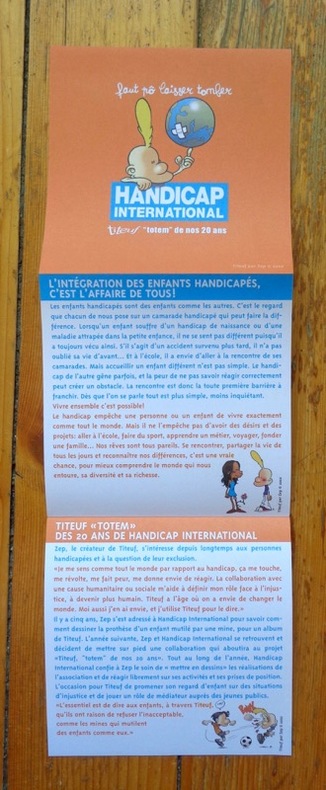
Zep:
Faut pô laisser tomber. Titeuf, totem de nos 20 ans.
Handicap International, 2002 Dépliant édité par Handicap international, illustré par Zep. Tout beau tout neuf.
Referência livreiro : 5476
|
|
|
Zep:
La Châtelaine de Genève.
Dépliant présentant le Domaine du Paradis, illustré par Zep et signé par lui au premier plat. Tout beau tout neuf.
Referência livreiro : 5475

|
|
|
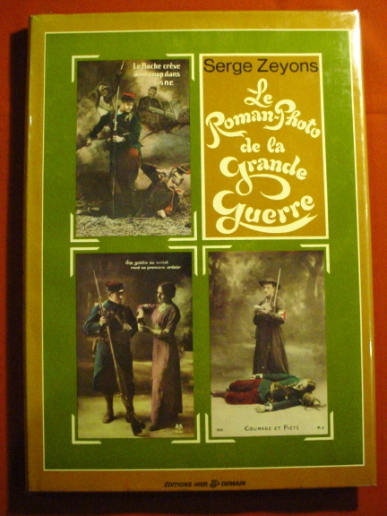
ZEYONS Serge
Le roman-photo de la Grande Guerre
Hier et Demain. 1976. In-4. Relié toilé. Bon état, Couv. convenable, Dos satisfaisant, Intérieur frais. 135p, illustré à chaque page de 330 cartes postales couleurs et noir et blanc dans le texte, relié toilé rose.. Avec Jaquette. . . Classification Dewey : 741.68-Illustrations des cartes postales
Referência livreiro : RO20017066
|
|
|
ZEYONS Serge
Le roman-photo de la Grande guerre.
Editions hier & demain, 1976. Grand album relié avec jaquette illustrée en couleurs, 135 pages avec d'innombrables reproductions de cartes postales anciennes sur la guerre de 1914-1918 (collection Henri Leblanc). Très bon état.
Referência livreiro : 16850
|
|
|
ZIEGLER, J.M. (Jakob Melchior 1801-1883)
Zur Hypsometrie der Schweiz und zur Orographie der Alpen. Erläuterungen für die hypsometrische Karte der Schweiz.
Winterthur, J. Wurster, 1866, in-8vo, VII + 1 S. (Inhaltsverz.) + 59 S. + 1 S. (Errata), Stempel auf Titelbl. S.A.C. Basel, ausgebunden, ohne Umschlag.
Referência livreiro : 57191aaf
|
|
|
Ziegenhirth, C
Die Welt in Karten: No. 9: Bayern. 16 farb. Spezialkarten mit Text und Namensverzeichnis des bayer. Gebietes.
Leipzig um 1924. Landkarte Faltmaß 18x12 cm.
Referência livreiro : 5140
|
|
|
Zimmermann A. et G.:
Calendrier 1994 - Regards en coin.
Genève, Société d'Art public, 1993. Calendrier pour l'année 1994, composé de cartes postales détachables, photographies de bâtiments de coin de Genève. Tout beau tout neuf.
Referência livreiro : 4458

|
|
|
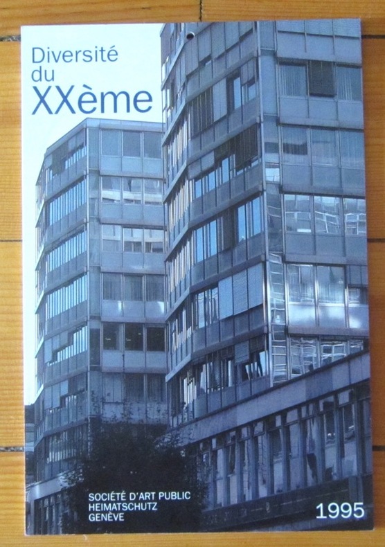
Zimmermann A. et G.:
Calendrier 1995 - Diversité du XXe.
Genève, Société d'Art public, 1994. Calendrier pour l'année 1995, composé de cartes postales détachables, photographies architecturales de Genève. Tout beau tout neuf.
Referência livreiro : 4459
|
|
|
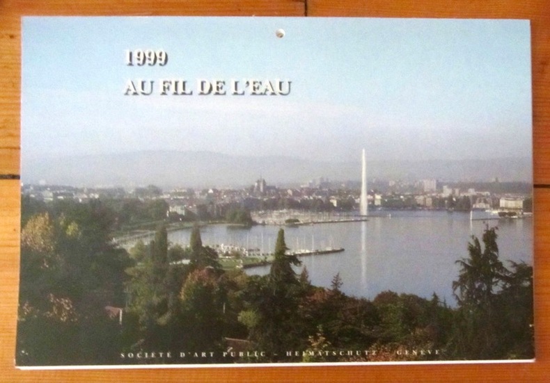
Zimmermann A. et G.:
Calendrier 1999 - Au fil de l'eau.
Genève, Société d'Art public, 1994. Calendrier pour l'année 1999, composé de cartes postales détachables, photographies de bâtiments de Genève. Les feuillets sont volants, mais le calendrier est bien complet.
Referência livreiro : 4461
|
|
|
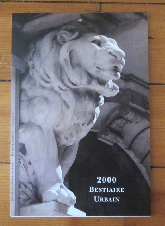
Zimmermann A. et G.:
Calendrier 2000 - Bestiaire urbain.
Genève, Société d'Art public, 1994. Calendrier pour l'année 2000, composé de cartes postales détachables, photographies d'animaux sur les bâtiments de Genève. Démonté en 3 parties, mais bien complet et en bon état.
Referência livreiro : 4462
|
|
|
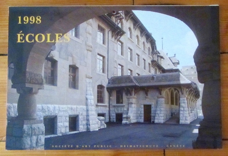
Zimmermann A. et G.:
Calendrier 1998 - Ecoles (Genève).
Genève, Société d'Art public, 1994. Calendrier pour l'année 1998, composé de cartes postales détachables, photographies de bâtiments scolaires de Genève. Tout beau tout neuf.
Referência livreiro : 4463
|
|
|
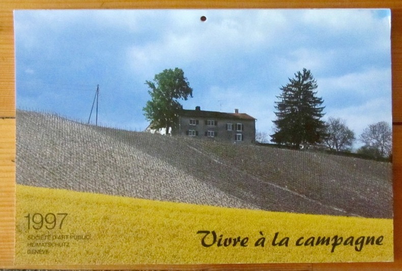
Zimmermann A. et G.:
Vivre à la campagne.
Société d'Art public, Genève, 1996. Calendrier pour l'année 1997, composé de cartes postales détachables, photographies de la campagne genevoise. En bon état.
Referência livreiro : 3344
|
|
|
ZIMMERN ALFRED WITH MAPS
THE GREEK COMMONWEALTH: POLITICS & ECONOMICS IN 5TH C ATHENS
CLARENDON PRESS 1931 5TH EDIT H/B. 1931. Hardcover. GOOD EXLIB LABELS & STAMPS BOXJW; 9694 . CLARENDON PRESS 1931 5TH EDIT H/B hardcover
Referência livreiro : 9694
|
|
|
ZOLA].
Gil Blas publie Au Bonheur des Dames, grand roman inédit par Emile Zola. Lithographie en couleurs (80 x 60 cm), sans nom d'artiste.
Paris Emile Lévy imprimeur, s.d. [1882] 1 vol. Broché Rare affiche annonçant la prépublication en feuilleton, entre décembre 1882 et mars 1883, du grand roman de Zola. "Cette affiche représente Denise Baudu, l'héroïne du Bonheur des dames, telle que Zola la décrit dans son roman : "Toutes [les vendeuses] avaient, entre deux boutonnières du corsage, comme piqué dans la poitrine un grand crayon qui se dressait, la pointe en l'air ; et l'on apercevait, sortant à demi d'une poche, la tache blanche du cahier de notes de débit". Cependant, les boucles d'oreille et la broche sont de trop car on peut lire au chapitre IX que "[Mouret] la regardait en souriant, dans sa robe de soie toute simple, sans un bijou". On peut expliquer cette inexactitude par le fait que le dessinateur ne disposait sans doute pas encore des derniers chapitres lorsqu'il composa cette affiche, Zola étant en retard sur son programme et le roman commençant à paraître sous forme de feuilleton avant d'être achevé." [Site pédagogique de la BnF]. Exemplaire entoilé, en parfaite condition.
Referência livreiro : 117250

|
|
|
ZOLA].
Gil Blas publie Au Bonheur des Dames, grand roman inédit par Emile Zola. Lithographie en couleurs (80 x 60 cm), sans nom d'artiste.
Paris Emile Lévy imprimeur, s.d. [1882] 1 vol. Broché Rare affiche annonçant la prépublication en feuilleton, entre décembre 1882 et mars 1883, du grand roman de Zola. "Cette affiche représente Denise Baudu, l'héroïne du Bonheur des dames, telle que Zola la décrit dans son roman : "Toutes [les vendeuses] avaient, entre deux boutonnières du corsage, comme piqué dans la poitrine un grand crayon qui se dressait, la pointe en l'air ; et l'on apercevait, sortant à demi d'une poche, la tache blanche du cahier de notes de débit". Cependant, les boucles d'oreille et la broche sont de trop car on peut lire au chapitre IX que "[Mouret] la regardait en souriant, dans sa robe de soie toute simple, sans un bijou". On peut expliquer cette inexactitude par le fait que le dessinateur ne disposait sans doute pas encore des derniers chapitres lorsqu'il composa cette affiche, Zola étant en retard sur son programme et le roman commençant à paraître sous forme de feuilleton avant d'être achevé." [Site pédagogique de la BnF]. Exemplaire entoilé, en parfaite condition.
Referência livreiro : 117250
|
|
|
Zorndorf:
Zorndorf. "Plan der Bataille welche von der Kayserl. Russischen und Königl. Preussischen Armee d. 25. Aug. 1758 bei Zorndorf ohnweit Cüstrin geliefert worden." Schlachtenplan von Zorndorf. Kupferstich mit farbigen Truppenaufstellungen aus "Neues Kriegs-Theater ...", No. 17.
Format: 18 x 29,5 cm. *Leicht gebräunt, insgesamt gut erhalten. Landkarten de
|
|
|
ZU DOHNA-SCHLODIEN Burgrave Nicolas, capitaine de corvette en retraite - René Jouan, lieutenant de vaisseau (traduit de l'allemand par)
La "Möwe": ses croisières et ses aventures. Avec 3 croquis, 2 cartes et 11 illustrations hors texte
1932 Payot, collection de mémoires, études et documents pour servir à l'histoire de la guerre mondiale - 1929 - In-8 broché - 222 pages - reproductions photographiques
Referência livreiro : 95409
|
|
|
ZUCCAGNI ORLANDINI (Attilio);
[FERRARA] Pianta della città di Ferrara.
circa 1850 525 x 340 mm.
Referência livreiro : LBW03595

|
|
|
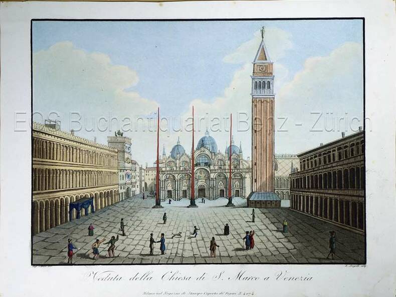
Zucoli:
Veduta della Chiesa di S. Marco a Venezia.
Milano, nel Negozio di Stampe sotto il Coperto de Figini N. 4074, (um 1820). Altkolorierte Aquatina von A. Angeli. Bildgrösse: 15 x 20,5 cm. Blattgrösse: 18,2 x 24,3 cm.
Referência livreiro : 772CG
|
|
|
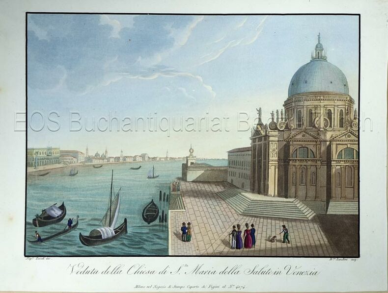
Zucoli:
Veduta della Chiesa di S.ta Maria della Salute in Venezia.
Milano, nel Negozio di Stampe Soperto de Figini al No. 4074. (um 1820). Altkolorierte Aquatina von Landini. Bildgrösse: 15,3 x 21 cm. Blattgrösse: 18,4 x 24,5 cm.
Referência livreiro : 770CG
|
|
|
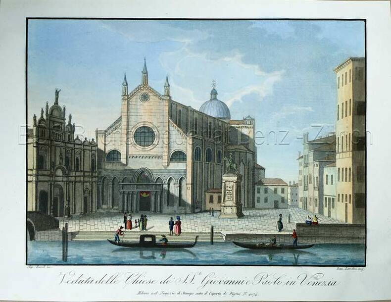
Zucoli:
Veduta delle Chiese de SS.ti Giovanni Paolo in Venezia.
Milano, nel Negozio di Stampe sotto il Coperto de Figini N. 4074, (um 1820). Altkolorierte Aquatina von Landini. Bildgrösse: 15 x 20,7 cm. Blattgrösse: 18,4 x 24 cm.
Referência livreiro : 771CG
|
|
|
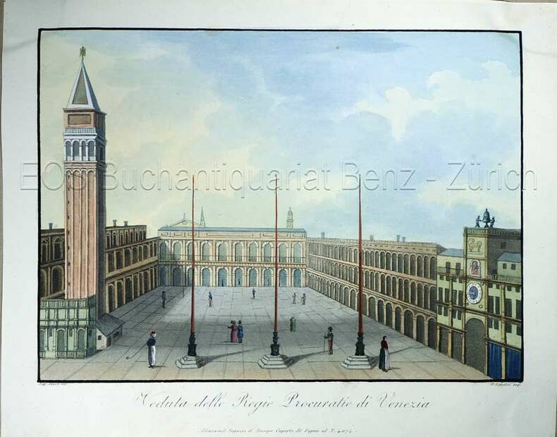
Zucoli:
Veduta delle Regie Procuratie di Venezia.
Milano, nel Negozio di Stampe sotto il Coperto de Figini al N. 4074, (um 1820). Altkolorierte Aquatina von D. Landini. Bildgrösse: 15,2 x 21 cm. Blattgrösse: 19 x 24 cm.
Referência livreiro : 773CG
|
|
|
ZUCCAGNI ORLANDINI Attilio (Fiesole 1784 - Firenze 1872)
Pianta della Città di Roma
Pianta tratta dall’Atlante geografico degli Stati italiani delineato sopra le migliori e più moderne mappe per servire di corredo alla corografia fisica storica e statistica dell'Italia, di Attilio Zuccagni Orlandini stampato a Firenze, presso gli editori, 1844. In 2° massimo, 2 voll. Il primo volume contenente le carte dell’Italia Superiore in 52 fogli, il secondo volume quelle dell’Italia Inferiore in 77 fogli. Attilio Zuccagni Orlandini (1784-1872) nacque a Fiesole con il nome di Giuseppe Orlandini. In seguito all’adozione da parte del facoltoso zio materno Attilio Zuccagni (1754-1807), botanico e georgofilo, assunse il nome di Attilio Zuccagni Orlandini. La sua più importante opera è la relazione geografico-cartografica di tutti gli Stati preunitari italiani, la grandiosa Corografia fisica, storica e statistica dell’Italia e delle sue Isole (Firenze 1835-1845), in dodici volumi per diciannove tomi, con un volume introduttivo sull’intera penisola italiana. L’opera costituì la summa delle centinaia di opere geografiche generali, regionali e locali allora disponibili e presentava, per ogni Stato preunitario, la trattazione fisica, storica, topografica e un inquadramento statistico. Nel 1844-45, la Corografia fu arricchita con cinque volumi di cartografie, vedute e altre illustrazioni di luoghi e monumenti: Atlante geografico degli Stati italiani delineato sopra le migliori e più moderne mappe (due volumi con 144 tavole inclusa la grande carta della penisola in 15 fogli) e Atlante illustrativo ossia raccolta dei principali monumenti italiani antichi, del medio evo e moderni e di alcune vedute pittoriche (tre volumi con 413 illustrazioni, stampate su 269 fogli). Le tavole furono incise, sempre a Firenze, in due apposite officine, da quattro valenti artisti lombardi (Vittorio Angeli, Giacinto Maina, Pietro Manzoni e Giuseppe Pozzi). Soprattutto il primo dei due atlanti rappresenta, ancora oggi, una pietra miliare nella storia della cartografia e dell’iconografia geografica italiana. Fu veramente ‘un’ardua impresa’, dal momento che spesso mancavano ancora (come, ad esempio, per il Ducato di Lucca e lo Stato Pontificio) prodotti cartografici compiutamente geometrici. I due prodotti furono presentati ai Georgofili nel 1843 e nel 1844, insieme alla mappa della Repubblica di San Marino. L’opera si rivelò oltremodo costosa e non ottenne il successo commerciale sperato, ma servì da base per tante altre iniziative editoriali successive che vi attinsero, talora senza neppure rispettarne i diritti d’autore. Incisione in rame, coloritura coeva dei contorni, lievi ossidazioni, per il resto in ottimo stato di conservazione. Bibliografia Cfr. Anna Guarducci - Dizionario Biografico degli Italiani - Volume 100 (2020). Plan taken from the Atlante geografico degli Stati italiani delineato sopra le migliori e più moderne mappe per servire di corredo alla corografia fisica storica e statistica dell'Italia, di Attilio Zuccagni Orlandini printed in Florence, 1844. The first volume contains the maps of Northern Italy in 52 sheets, the second volume those of Southern Italy in 77 sheets. Attilio Zuccagni Orlandini (1784-1872) was born in Fiesole under the name of Giuseppe Orlandini. Following adoption by his wealthy maternal uncle Attilio Zuccagni (1754-1807), a botanist and georgofile, he took the name Attilio Zuccagni Orlandini. His most important work is the geographic-cartographic report of all the pre-unification Italian states, the great Corografia fisica, storica e statistica dell'Italia e delle sue Isole (Florence 1835-1845), in twelve volumes for nineteen tomes, with an introductory volume on the entire Italian peninsula. The work constituted the sum of hundreds of general, regional and local geographic works then available and presented, for each pre-unification state, the physical, historical, topographical and statistical framework. In 1844-45, the Corografia was enriched with five volumes of maps, views and other illustrations of places and monuments: Atlante geografico degli Stati italiani delineato sopra le migliori e più moderne mappe (two volumes with 144 plates including the large map of the peninsula in 15 sheets) and Atlante illustrativo ossia raccolta dei principali monumenti italiani antichi, del medio evo e moderni e di alcune vedute pittoriche (three volumes with 413 illustrations, printed on 269 sheets). The plates were engraved, again in Florence, in two special workshops, by four talented Lombard artists (Vittorio Angeli, Giacinto Maina, Pietro Manzoni and Giuseppe Pozzi). Especially the first of the two atlases represents, even today, a milestone in the history of cartography and Italian geographic iconography. It was truly 'an arduous undertaking', since cartographic products were often still lacking (as, for example, for the Duchy of Lucca and the Papal States) fully geometric. The two products were presented to the Georgofili in 1843 and 1844, along with the map of the Republic of San Marino. The work proved to be very expensive and did not achieve the commercial success hoped for, but served as a basis for many other subsequent publishing initiatives that drew on it, sometimes without even respecting the copyright. Copperplate with fine outline colour, good condition. Literature Anna Guarducci - Dizionario Biografico degli Italiani - Volume 100 (2020).

|
|
|
Zucoli
Veduta della Chiesa di S. Marco a Venezia.
Milano, nel Negozio di Stampe sotto il Coperto de Figini N. 4074, (um 1820). Altkolorierte Aquatina von A. Angeli. Bildgrösse: 15 x 20,5 cm. Blattgrösse: 18,2 x 24,3 cm. + Wichtig: Für unsere Kunden in der EU erfolgt der Versand alle 14 Tage verzollt ab Deutschland / Postbank-Konto in Deutschland vorhanden +, Bild
Referência livreiro : 772CG

|
|
|
Zucoli
Veduta della Chiesa di S.ta Maria della Salute in Venezia.
Milano, nel Negozio di Stampe Soperto de Figini al No. 4074., (um 1820). Altkolorierte Aquatina von Landini. Bildgrösse: 15,3 x 21 cm. Blattgrösse: 18,4 x 24,5 cm. + Wichtig: Für unsere Kunden in der EU erfolgt der Versand alle 14 Tage verzollt ab Deutschland / Postbank-Konto in Deutschland vorhanden +, Bild
Referência livreiro : 770CG

|
|
|
Zucoli
Veduta delle Chiese de SS.ti Giovanni Paolo in Venezia.
Milano, nel Negozio di Stampe sotto il Coperto de Figini N. 4074, (um 1820). Altkolorierte Aquatina von Landini. Bildgrösse: 15 x 20,7 cm. Blattgrösse: 18,4 x 24 cm. + Wichtig: Für unsere Kunden in der EU erfolgt der Versand alle 14 Tage verzollt ab Deutschland / Postbank-Konto in Deutschland vorhanden +, Bild
Referência livreiro : 771CG

|
|
|
Zucoli
Veduta delle Regie Procuratie di Venezia.
Milano, nel Negozio di Stampe sotto il Coperto de Figini al N. 4074, (um 1820). Altkolorierte Aquatina von D. Landini. Bildgrösse: 15,2 x 21 cm. Blattgrösse: 19 x 24 cm. + Wichtig: Für unsere Kunden in der EU erfolgt der Versand alle 14 Tage verzollt ab Deutschland / Postbank-Konto in Deutschland vorhanden +, Bild
Referência livreiro : 773CG

|
|
|
ZUEHLKE Mark text. Maps by C. Stuart Daniel
THE CANADIAN MILITARY ATLAS The Nation's Battlefields from the French and Indian Wars to Kosovo
Toronto: Stoddart 2001. 1st edition. Hardcover. maps photos illustrations. pp. xi 228.4toVery. sl. bumped; else vg/nf in sl. scuffed o/w vg/nf dj <br/><br/>Eighty intricately detailed maps and 50 photos of 400 years of Canada's battlefields. ISBN 0773732896 Stoddart hardcover
Referência livreiro : 9900045107 ISBN : 0773732896 9780773732896
|
|
|
Zuehlke Mark maps by C Stuart Daniel
The Canadian Military Atlas : The Nation's Battlefields from the French and Indian Wars to Kosovo
Toronto : Stoddart 2001 . First Edition . Fine/Fine . Folio . A beautifully produced book with extensive text many illustrations and colour maps of dozens of battlefields in Canada and overseas. A fine copy. A large and heavy book special shipping considerations may apply. Stoddart unknown
Referência livreiro : 30857 ISBN : 0773732896 9780773732896

|
|
|
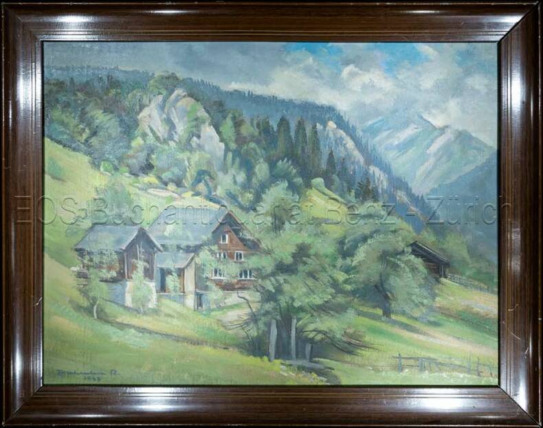
Zurkinden, Rudold:
Berglandschaft mit Bauernhaus.
1947. Oel auf Leinwand. Bildausschnitt: 37 x 49 cm.
Referência livreiro : 811CG
|
|
|
ZURBRIGGEN, Bernhard:
Schauen und Wandern im freiburgischen Senseland. Ein Naturkundeführer.
Wünnewill, Bernhard Zurbriggen, 1996, in-8vo, 223 S., reich ill. mit farbig Fotor. und Abbildungen, Original-Broschüre.
Referência livreiro : 109147aaf
|
|
|
Zur Westen, Walter v
Berlins graphische Gelegenheitskunst.
Berlin, Otto v. Holten, 1912. 4°. [2] w. Bl., [7] Bl., 199 S., [1] Bl.; [2] w. Bl., [5] Bl., 183 S., [1] Bl. mit Titel in Rot und Schwarz und 113 teils montierten Abbildungen und 1 Holzschnitt, 6 Radierungen, 12 Lithographien und 1 Prägedruck nach Hans Baluschek, Franz v. Bayros, Ludwig Burger, Daniel Chodowiecki, Fidus, Max Klinger, Max Liebermann, Adolph Menzel, Max Slevogt u. a. Orig.-Halbpergamentbände mit goldgepr. Rückentiteln und Rückenvergoldung (Entwurf: E. Doepler). 2 Bände.
Referência livreiro : 107028BB
|
|
|
Zurkinden, Rudold
Berglandschaft mit Bauernhaus.
1947. Oel auf Leinwand. Bildausschnitt: 37 x 49 cm. + Wichtig: Für unsere Kunden in der EU erfolgt der Versand alle 14 Tage verzollt ab Deutschland / Postbank-Konto in Deutschland vorhanden +, Abb.
Referência livreiro : 811CG

|
|
|
ZURNER Adam Friedrich (1679 - 1742)
Planisphaerium Terrestre Cum Utroque Coelesti, Sive Diversa Orbis Terraquei…
Bell'esemplare della rara mappa del doppio emisfero del mondo di Adam Freidrich Zurner, impreziosita da 26 scene decorative e proiezioni scientifiche dei cieli celesti e teorie e insegnamenti astronomici contemporanei.Il lavoro di Zürner è relativamente sconosciuto, di solito appare negli atlanti di altri editori, come l'Atlas Contractus di Schenk o della famiglia Ottens.Una mappa attraente e interessante ricca di dettagli che comprende la maggior parte della costa dell'Australia, la costa occidentale della Nuova Zelanda e le rotte e le scoperte degli esploratori Magellano, Dampier ("Nova Britannia" nel 1700), Tasman, Gaetani e Chaumont. Intorno alla mappa c'è un bordo elaborato che mostra venti e climi e lungo il bordo inferiore un panorama che illustra tempeste, terremoti, maree, vortici e un commento testuale su tutti i fenomeni naturali illustrati. Acquaforte, finemente colorata a mano in epoca, in ottimo stato di conservazione. Fine example of Adam Freidrich Zurner's scarce double hemisphere map of the World, embellished with 26 decorative scenes and scientific projections of the Celestial skies and contemporary astronomical theories and teachings.Zürner's work is relatively unknown, appearing usually in other publishers' atlases, such as Schenk's Atlas Contractus.An attractive and interesting map full of detail including most of the coast of Australia, the western coast of New Zealand, and the routes and discoveries of explorers Magellan, Dampier ("Nova Britannia" in 1700), Tasman, Gaetani and Chaumont. Surrounding the map is an elaborate border showing winds and climates, and along the bottom edge a panorama illustrating tempests, earthquakes, tides, vortices, and a textual commentary on all the natural phenomena illustrated.California is shown as an island, but very tentatively so, with the coloring suggesting that it may be a peninsula, suggesting early knowledge of Fra. Eusebio Kino's observations from California. Copperplate, fine original colouring, good condition. Shirley, The Mapping of the World, n. 639.

|
|
|
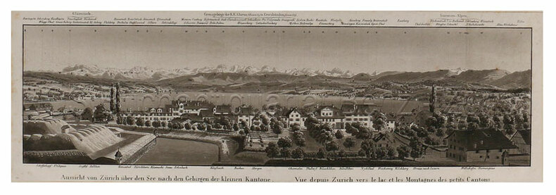
Zürich. – Schmid, Franz (1796-1851):
Aussicht von Zürich über den See nach den Gebirgen der kleinen Kantone. – Vue depuis Zurich vers le lac et les montagnes de petits Cantons.
(Zürich, Keller, 1829). Aquatinta auf Papier. Bildgrösse: 10,5 x 38,7 cm. Blattgrösse: 13 x 40,5 cm.
Referência livreiro : 597DG
|
|
|
ÁLVARO ZAMORA, María Isabel [et al.].
El plano más antiguo de Zaragoza. Descripciones literarias e imágenes dibujadas de la capital aragonesa en la Edad Moderna (1495-1614).
Zaragoza, 2010. Folio; 179 pp., con 78 ilustraciones en color entre el texto y un mapa plegado. Cubiertas originales.

|
|
|
Étienne Bézout
Suite du cours de mathématiques, à l'usage des gardes du pavillon et de la marine, contenant le traité de navigation
1793, Ph.-D. Pierres, Paris. In-8, relié, plein veau de l'époque, dos lisse orné, XII-296pp suivies des "tables à l'usage de la navigation" [45 ff] et bien complet des 10 planches dépliantes in fine. Cachets humides colorés sur le contreplat, ex-libris à la plume sur le faux-titre. Très bon exemplaire
Referência livreiro : MAR923M
|
|
|
 Receber por correio electrónico
 Descarregar em documento PDF
 Fluxo RSS
