|
|
|
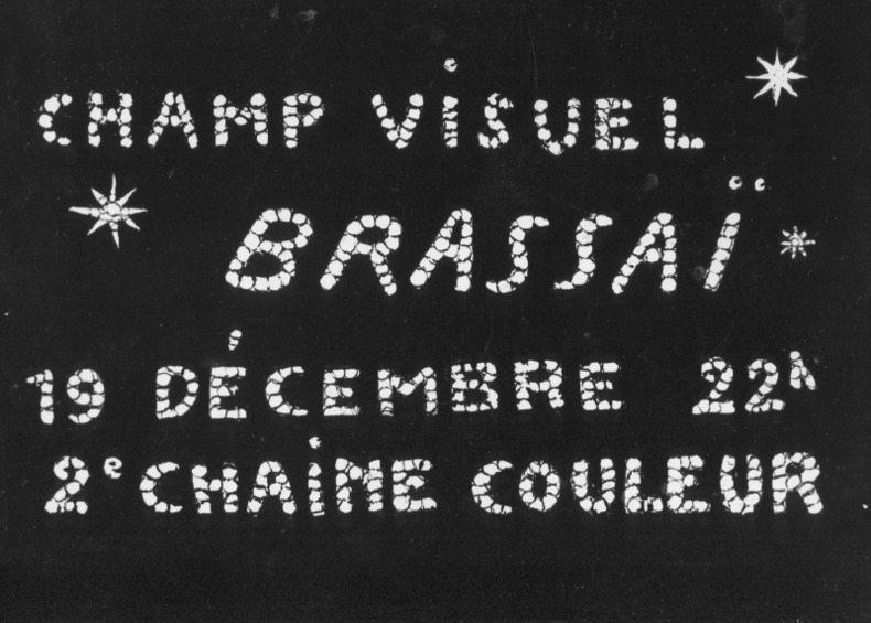
BRASSAI.
Photo-carte avec la signature autographe de Brassaï au verso (années 1970).
Carte postale (10,5 x 15 cm), années 70. Annonce du documentaire télévisé "Champ visuel Brassaï - 19 décembre 22 h - 2e chaîne couleur". Signé au dos par le photographe.
Referenz des Buchhändlers : 68129
|
|
|
BRASSAI.
Photo-carte avec la signature autographe de Brassaï au verso (années 1970).
Carte postale (10,5 x 15 cm), années 70. Annonce du documentaire télévisé "Champ visuel Brassaï - 19 décembre 22 h - 2e chaîne couleur". Signé au dos par le photographe.
Referenz des Buchhändlers : 68129
|
|
|
BRAUN & Franz HOGENBERG Georg
Antiqua Urbis Roma Imago Accuratissima
Grande pianta della città stampata su due fogli, ispirata alla celebre carta del Pirro Ligorio, tratta dal Civitates Orbis Terrarum. Questa straordinaria ricostruzione di Roma durante il regno di Augusto, arricchita da una cospicua legenda con 269 richiami, costituisce il lavorò più ambizioso contenuto nel Civitates Orbis Terrarum, del quale oltretutto è una delle sole tre mappe a doppio foglio. L’opera è inserita nel Civitates Orbis Terrarum, il primo atlante devoto esclusivamente alle piante e vedute delle principali città del mondo. Il primo volume delle Civitates Orbis Terrarum fu pubblicato a Colonia nel 1572. Il sesto e ultimo volume apparve nel 1617. Questo grande atlante di città – cartografia urbana - curato da Georg Braun e inciso in gran parte da Franz Hogenberg, conteneva 546 prospettive, vedute a volo d'uccello e vedute cartografiche di città di tutto il mondo. Franz Hogenberg realizzò le tavole dei primi quattro volumi e Simon van den Neuwel (Novellanus, attivo dal 1580) quelle dei volumi V e VI. Georg Braun (1541-1622), un ecclesiastico di Colonia, fu il principale redattore dell'opera e fu molto aiutato nel suo progetto dalla vicinanza e dal continuo interesse di Abraham Ortelius, il cui Theatrum Orbis Terrarum del 1570 fu, come raccolta sistematica e completa di mappe di stile uniforme, il primo vero atlante. Le Civitates, in effetti, erano destinate ad accompagnare il Theatrum, come indicato dalla somiglianza dei titoli e dai riferimenti contemporanei sulla natura complementare delle due opere. Tuttavia, le Civitates erano progettate per avere un approccio più popolare, senza dubbio perché la novità di una raccolta di piante e vedute di città rappresentava un'impresa commerciale più rischiosa di un atlante mondiale, per il quale c'erano stati diversi precedenti di successo. Franz Hogenberg (1535-1590) era figlio di un incisore di Monaco che si era stabilito a Malines. Incise la maggior parte delle tavole del Theatrum di Ortelius e la maggior parte di quelle delle Civitates, e potrebbe essere anche indicato come il responsabile dell'origine del progetto. Oltre un centinaio di artisti e cartografi diversi, il più importante dei quali fu l'artista di Anversa Georg Hoefnagel (1542-1600), fornirono i disegni per le tavole delle Civitates. Hoefnagel non solo contribuì alla maggior parte del materiale originale per le città spagnole e italiane, ma rielaborò e modificò anche quello di altri collaboratori. Dopo la morte di Hoefnagel, il figlio Jakob continuò il lavoro per le Civitates. Gli autori della raccolta si proponevano di raffigurare "non icones et typi urbium", cioè non immagini generiche e tipizzate, "sed urbes ipsae admirabili caelaturae artificio, spectantium oculis subiectae appareant": non intendeva alludere o idealizzare, ma rappresentare fedelmente sulla carta, riprodurre esattamente, e in tempo reale, ciò che l'occhio vede, come annunciato nella prefazione al primo volume delle Civitates Orbis Terrarum. Incisione in rame, bella coloritura coeva, leggeri restauri perfettamente eseguiti per il resto in buono stato di conservazione. A good example, with fine original colour, of the Braun & Hogenberg Plan of Rome, first published in the 1588 edition of the Civitates Orbis Terrarum.Braun & Hogenberg's view is based upon the work of Pirro Ligorio. However, the title banner and lower key embellishments are completely revised, the former lacking the strapwork used by Braun & Hogenberg and replaced with a tapestry style fringe, while the lower key is now embellished with images of two nobles.Rome is shown from the west in a bird's-eye view that was a major achievement in its day. It includes the most important buildings from antiquity, several aqueducts, the Aurelian Wall and large arterial streets. The three figures in Roman garb in the foreground underscore the aim of meticulous reconstruction.Mont Testaccio is shown on the far side of the Tiber in the lower right-hand edge of the picture, with the Pyramid of Cestius above it to the right. At the center of the illustration the Marcellus Theatre can be identified above the island in the Tiber, with the vast Circus Maximus, used for chariot races, just above it to the right. Above that is the Palatine represented with intricately detailed buildings, an indication of the confusion at the time about how the seat of imperial power actually looked.To the north the Coliseum flanks the Palatine. In the lower left-hand part of the picture field is the Campus Martius, with the stadium of Domitian at the center, site of the modern Piazza Navona. Slightly higher up is the Pantheon with its monumental dome, looking as it does today. On the lower left edge the two great imperial mausoleums are shown as they would have appeared during the Roman epoch. Above the mausoleum of Augustus and below, at the bend in the river, is that of Hadrian.In the lower left-hand corner, the Mons Vaticanus with the Circus built by Caligua and a Neronian palace are recognizable outside the city. The baths of Diocletan dominate the northeastern part of the city. The Castra Praetoria, the barracks of the Praetorian Guard, is shown below the city walls in the upper left-hand corner. The work is included in the Civitates Orbis Terrarum, the first atlas devoted exclusively to plans and views of the world's major cities. Printed in six volumes between 1572 and 1617 it was so successful and widespread that several editions translated into Latin, German and French were printed. The first volume of the Civitates Orbis Terrarum was published in Cologne in 1572. The sixth and the final volume appeared in 1617. This great city atlas, edited by Georg Braun and largely engraved by Franz Hogenberg, eventually contained 546 prospects, bird-eye views and map views of cities from all over the world. Fransz Hogenberg produced the plates for the first four books, and Simon van den Neuwel (Novellanus, active since 1580) those for volumes V and VI. Georg Braun (1541-1622), a cleric of Cologne, was the principal editor of the work, and was greatly assisted in his project by the close, and continued interest of Abraham Ortelius, whose Theatrum Orbis Terrarum of 1570 was, as a systematic and comprehensive collection of maps of uniform style, the first true atlas. The Civitates, indeed, was intended as a companion for the Theatrum, as indicated by the similarity in the titles and by contemporary references regarding the complementary nature of two works. Nevertheless, the Civitates was designs to be more popular in approach, no doubt because the novelty of a collection of city plans and views represented a more hazardous commercial undertaking than a world atlas, for which there had been a number of successful precedents. Franz Hogenberg (1535-1590) was the son of a Munich engraves who settled in Malines. He engraved most of the plates for Ortelius's Theatrum and the majority of those in the Civitates, and may have been responsible for originating the project. Over a hundred of different artists and cartographers, the most significant of w... Fauser, A. 11932; Huelsen (1915) n. 38; Caldana, Roma Antica, p. 84, n. I.17.

|
|
|
BRAUN & Franz HOGENBERG Georg
Roma
Sorprendente veduta a volo d'uccello di Roma con cartiglio decorativo con titolo, che mostra la città com'era nel 1550. Sono incluse varie strutture superstiti dell'antica Roma: le mura circostanti, il Pantheon, il Colosseo, l'Arco di Costantino e il Foro Romano. Nell'angolo sinistro in primo piano si possono vedere il Palazzo Papale e l'Obelisco dal circo di Caligola e Nerone. In basso due figure in primo piano e due ampie tabelle con la legenda."E' una copia ridotta della pianta del Camocio (o della precedente di Leon Pitor come sostiene Scaccia Scarafoni) nella quale la città è ritratta a volo d'uccello dal Gianicolo" (cfr. Marigliani p. 152). L’opera è inserita nel Civitates Orbis Terrarum, il primo atlante devoto esclusivamente alle piante e vedute delle principali città del mondo. Il primo volume delle Civitates Orbis Terrarum fu pubblicato a Colonia nel 1572. Il sesto e ultimo volume apparve nel 1617. Questo grande atlante di città – cartografia urbana - curato da Georg Braun e inciso in gran parte da Franz Hogenberg, conteneva 546 prospettive, vedute a volo d'uccello e vedute cartografiche di città di tutto il mondo. Franz Hogenberg realizzò le tavole dei primi quattro volumi e Simon van den Neuwel (Novellanus, attivo dal 1580) quelle dei volumi V e VI. Georg Braun (1541-1622), un ecclesiastico di Colonia, fu il principale redattore dell'opera e fu molto aiutato nel suo progetto dalla vicinanza e dal continuo interesse di Abraham Ortelius, il cui Theatrum Orbis Terrarum del 1570 fu, come raccolta sistematica e completa di mappe di stile uniforme, il primo vero atlante. Le Civitates, in effetti, erano destinate ad accompagnare il Theatrum, come indicato dalla somiglianza dei titoli e dai riferimenti contemporanei sulla natura complementare delle due opere. Tuttavia, le Civitates erano progettate per avere un approccio più popolare, senza dubbio perché la novità di una raccolta di piante e vedute di città rappresentava un'impresa commerciale più rischiosa di un atlante mondiale, per il quale c'erano stati diversi precedenti di successo. Franz Hogenberg (1535-1590) era figlio di un incisore di Monaco che si era stabilito a Malines. Incise la maggior parte delle tavole del Theatrum di Ortelius e la maggior parte di quelle delle Civitates, e potrebbe essere anche indicato come il responsabile dell'origine del progetto. Oltre un centinaio di artisti e cartografi diversi, il più importante dei quali fu l'artista di Anversa Georg Hoefnagel (1542-1600), fornirono i disegni per le tavole delle Civitates. Hoefnagel non solo contribuì alla maggior parte del materiale originale per le città spagnole e italiane, ma rielaborò e modificò anche quello di altri collaboratori. Dopo la morte di Hoefnagel, il figlio Jakob continuò il lavoro per le Civitates. Gli autori della raccolta si proponevano di raffigurare "non icones et typi urbium", cioè non immagini generiche e tipizzate, "sed urbes ipsae admirabili caelaturae artificio, spectantium oculis subiectae appareant": non intendeva alludere o idealizzare, ma rappresentare fedelmente sulla carta, riprodurre esattamente, e in tempo reale, ciò che l'occhio vede, come annunciato nella prefazione al primo volume delle Civitates Orbis Terrarum. Incisione in rame, finemente colorata a mano, lieve gora d'acqua nel margine inferiore destro, piega di carta centrale, per il resto in ottimo stato di conservazione.BibliografiaA. P. Frutaz, "Le piante di Roma", tav. 123; C. Marigliani, "Le Piante di Roma delle collezioni private", n. 52; M. Gori Sassoli (a cura di), "Roma Veduta" n. 12; Scaccia Scarafoni, "Le Piante di Roma", n. 156. Striking bird's-eye plan of Rome with decorative title cartouche, showing the city as it was c. 1550. Included are various surviving features of ancient Rome: the surrounding walls, the Pantheon, the Coliseum, the Arch of Constantine, and the Forum Romanum. In the left corner in the foreground can be seen the Papal Palace and the Obelisk from the circus of Caligula and Nero. With two figures in the foreground, and two extensive tables of explanations."E' una copia ridotta della pianta del Camocio (o della precedente di Leon Pitor come sostiene Scaccia Scarafoni) nella quale la città è ritratta a volo d'uccello dal Gianicolo" (cfr. Marigliani p. 152). The work is included in the Civitates Orbis Terrarum, the first atlas devoted exclusively to plans and views of the world's major cities. Printed in six volumes between 1572 and 1617 it was so successful and widespread that several editions translated into Latin, German and French were printed. The first volume of the Civitates Orbis Terrarum was published in Cologne in 1572. The sixth and the final volume appeared in 1617. This great city atlas, edited by Georg Braun and largely engraved by Franz Hogenberg, eventually contained 546 prospects, bird-eye views and map views of cities from all over the world. Fransz Hogenberg produced the plates for the first four books, and Simon van den Neuwel (Novellanus, active since 1580) those for volumes V and VI. Georg Braun (1541-1622), a cleric of Cologne, was the principal editor of the work, and was greatly assisted in his project by the close, and continued interest of Abraham Ortelius, whose Theatrum Orbis Terrarum of 1570 was, as a systematic and comprehensive collection of maps of uniform style, the first true atlas. The Civitates, indeed, was intended as a companion for the Theatrum, as indicated by the similarity in the titles and by contemporary references regarding the complementary nature of two works. Nevertheless, the Civitates was designs to be more popular in approach, no doubt because the novelty of a collection of city plans and views represented a more hazardous commercial undertaking than a world atlas, for which there had been a number of successful precedents. Franz Hogenberg (1535-1590) was the son of a Munich engraves who settled in Malines. He engraved most of the plates for Ortelius's Theatrum and the majority of those in the Civitates, and may have been responsible for originating the project. Over a hundred of different artists and cartographers, the most significant of whom was Antwerp artist Georg Hoefnagel (1542-1600), engraved the cooper-plates of the Civitates from drawings. He not only contributed most of the original material for the Spanish and Italian towns but also reworked and modified those of other contributors. After Hoefnagel's death his son Jakob continued the work for the Civitates. The author set out to depict "non icones et typi urbium," that is, not generic and typified images, "sed urbes ipsae admirabili caelaturae artificio, spectantium oculis subiectae appareant": not intended to allude or idealize but to represent faithfully on paper, to reproduce exactly, and in real time, what the eye sees, as announced in the preface to the first volume of Civitates Orbis Terrarum. Etching on copperplate with original hand colour, a light waterstain in the lower right corner, otherwise in good conditions.BibliografiaA. P. Frutaz, "Le piante di Roma", tav. 123; C. Marigliani, "Le Piante di Roma delle collezioni private", n. 52; M. Gori Sassoli (a cura di), "Roma Veduta" n. 12; Scaccia Scarafoni, "Le Piante di Roma", n. 156.

|
|
|
BRAUN & Franz HOGENBERG Georg
Urbis Romae Situs Cum Iis Quae Adhuc Conspiciuntur Veter Monumet Reliquiis Pyrrho Ligorio...
Pianta archeologica di Roma, a proiezione verticale obliqua, orientata con il nord in alto.La pianta deriva da quella che Pirro Ligorio disegna per l'editore Michele Tramezzino nel 1552. Si tratta della prima derivazione stampata all'estero ed è ridotta leggermente nelle dimensioni. Erroneamente viene indicata come data d'esecuzioni il 1570, invece del 1552. Appare per la prima volta nel 1575, inserita nel Civitates Orbis Terrarum, il primo atlante devoto esclusivamente alle piante e vedute delle principali città del mondo. L’opera è inserita nel Civitates Orbis Terrarum, il primo atlante devoto esclusivamente alle piante e vedute delle principali città del mondo. Il primo volume delle Civitates Orbis Terrarum fu pubblicato a Colonia nel 1572. Il sesto e ultimo volume apparve nel 1617. Questo grande atlante di città – cartografia urbana - curato da Georg Braun e inciso in gran parte da Franz Hogenberg, conteneva 546 prospettive, vedute a volo d'uccello e vedute cartografiche di città di tutto il mondo. Franz Hogenberg realizzò le tavole dei primi quattro volumi e Simon van den Neuwel (Novellanus, attivo dal 1580) quelle dei volumi V e VI. Georg Braun (1541-1622), un ecclesiastico di Colonia, fu il principale redattore dell'opera e fu molto aiutato nel suo progetto dalla vicinanza e dal continuo interesse di Abraham Ortelius, il cui Theatrum Orbis Terrarum del 1570 fu, come raccolta sistematica e completa di mappe di stile uniforme, il primo vero atlante. Le Civitates, in effetti, erano destinate ad accompagnare il Theatrum, come indicato dalla somiglianza dei titoli e dai riferimenti contemporanei sulla natura complementare delle due opere. Tuttavia, le Civitates erano progettate per avere un approccio più popolare, senza dubbio perché la novità di una raccolta di piante e vedute di città rappresentava un'impresa commerciale più rischiosa di un atlante mondiale, per il quale c'erano stati diversi precedenti di successo. Franz Hogenberg (1535-1590) era figlio di un incisore di Monaco che si era stabilito a Malines. Incise la maggior parte delle tavole del Theatrum di Ortelius e la maggior parte di quelle delle Civitates, e potrebbe essere anche indicato come il responsabile dell'origine del progetto. Oltre un centinaio di artisti e cartografi diversi, il più importante dei quali fu l'artista di Anversa Georg Hoefnagel (1542-1600), fornirono i disegni per le tavole delle Civitates. Hoefnagel non solo contribuì alla maggior parte del materiale originale per le città spagnole e italiane, ma rielaborò e modificò anche quello di altri collaboratori. Dopo la morte di Hoefnagel, il figlio Jakob continuò il lavoro per le Civitates. Gli autori della raccolta si proponevano di raffigurare "non icones et typi urbium", cioè non immagini generiche e tipizzate, "sed urbes ipsae admirabili caelaturae artificio, spectantium oculis subiectae appareant": non intendeva alludere o idealizzare, ma rappresentare fedelmente sulla carta, riprodurre esattamente, e in tempo reale, ciò che l'occhio vede, come annunciato nella prefazione al primo volume delle Civitates Orbis Terrarum. Incisione in rame, finemente colorata a mano, in ottimo stato di conservazione. Archeological map of Rome published in the Civitates Orbis Terrarum of 1575.The map is a close copy of the Pirro Ligorio map of Rome (1552, published by Michele Tramezzino) reduced in size. Latin text edition. The work is included in the Civitates Orbis Terrarum, the first atlas devoted exclusively to plans and views of the world's major cities. Printed in six volumes between 1572 and 1617 it was so successful and widespread that several editions translated into Latin, German and French were printed. The first volume of the Civitates Orbis Terrarum was published in Cologne in 1572. The sixth and the final volume appeared in 1617. This great city atlas, edited by Georg Braun and largely engraved by Franz Hogenberg, eventually contained 546 prospects, bird-eye views and map views of cities from all over the world. Fransz Hogenberg produced the plates for the first four books, and Simon van den Neuwel (Novellanus, active since 1580) those for volumes V and VI. Georg Braun (1541-1622), a cleric of Cologne, was the principal editor of the work, and was greatly assisted in his project by the close, and continued interest of Abraham Ortelius, whose Theatrum Orbis Terrarum of 1570 was, as a systematic and comprehensive collection of maps of uniform style, the first true atlas. The Civitates, indeed, was intended as a companion for the Theatrum, as indicated by the similarity in the titles and by contemporary references regarding the complementary nature of two works. Nevertheless, the Civitates was designs to be more popular in approach, no doubt because the novelty of a collection of city plans and views represented a more hazardous commercial undertaking than a world atlas, for which there had been a number of successful precedents. Franz Hogenberg (1535-1590) was the son of a Munich engraves who settled in Malines. He engraved most of the plates for Ortelius's Theatrum and the majority of those in the Civitates, and may have been responsible for originating the project. Over a hundred of different artists and cartographers, the most significant of whom was Antwerp artist Georg Hoefnagel (1542-1600), engraved the cooper-plates of the Civitates from drawings. He not only contributed most of the original material for the Spanish and Italian towns but also reworked and modified those of other contributors. After Hoefnagel's death his son Jakob continued the work for the Civitates. The author set out to depict "non icones et typi urbium," that is, not generic and typified images, "sed urbes ipsae admirabili caelaturae artificio, spectantium oculis subiectae appareant": not intended to allude or idealize but to represent faithfully on paper, to reproduce exactly, and in real time, what the eye sees, as announced in the preface to the first volume of Civitates Orbis Terrarum. Copperplate with fine later hand colour, good condition. Scaccia Scarafoni p. 29, n. 22.

|
|
|
BRAUN (Georg) & HOGENBERG (Frans) & JANSSON (Johannes).
[IRLANDE] Galwaye - Dubline - Lymericke - Corcke.
[Amsterdam, 1657]. 306 x 438 mm.
Referenz des Buchhändlers : LBW-3186

|
|
|
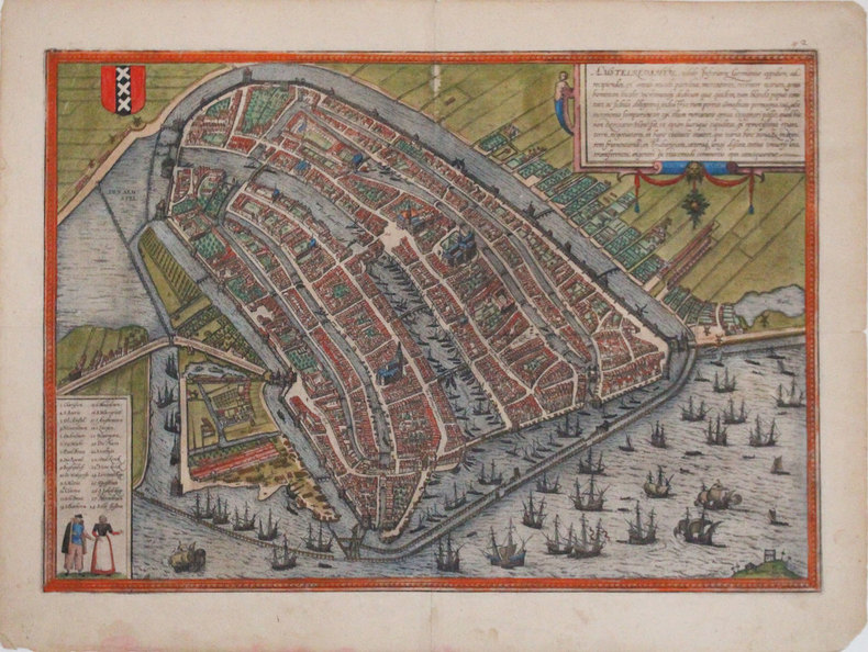
BRAUN (Georg) & HOGENBERG (Frans).
[AMSTERDAM] Amstelredamum, nobile Inferioris Germaniæ oppidum.
[Cologne, 1572]. 338 x 486 mm.
Referenz des Buchhändlers : LBW-3255
|
|
|
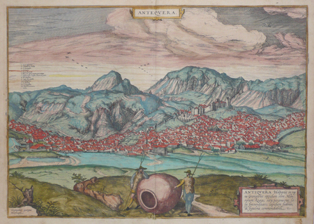
BRAUN (Georg) & HOGENBERG (Frans).
[ANDALOUSIE] Antequera.
[Cologne, 1572]. 351 x 497 mm.
Referenz des Buchhändlers : LBW0621c
|
|
|
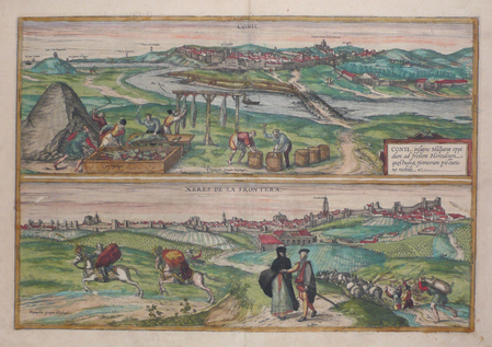
BRAUN (Georg) & HOGENBERG (Frans).
[ANDALOUSIE] Conil - Xeres de la Frontera.
[Cologne, 1572]. 351 x 497 mm.
Referenz des Buchhändlers : LBW0621b
|
|
|
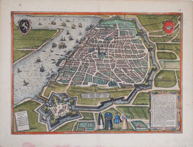
BRAUN (Georg) & HOGENBERG (Frans).
[ANVERS] Anverpia.
[Cologne, 1572]. 338 x 479 mm.
Referenz des Buchhändlers : LBW-3249
|
|
|
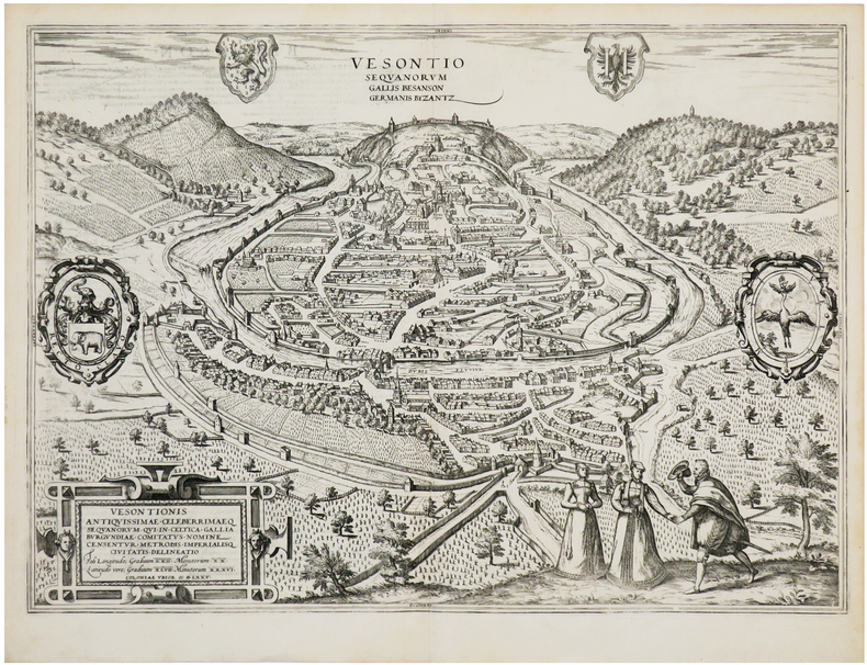
BRAUN (Georg) & HOGENBERG (Frans).
[BESANÇON] Vesontio Sequanorum Gallis Besanson Germanis Byzantz.
[Cologne, 1575]. 353 x 493 mm.
Referenz des Buchhändlers : LBW-7194
|
|
|
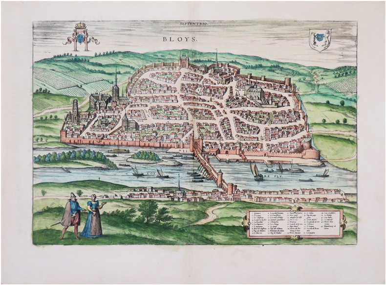
BRAUN (Georg) & HOGENBERG (Frans).
[BLOIS] Bloys.
[Cologne, 1575]. 308 x 438 mm.
Referenz des Buchhändlers : LBW-7902
|
|
|
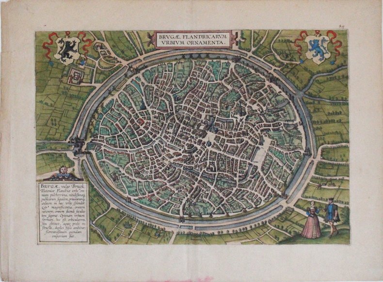
BRAUN (Georg) & HOGENBERG (Frans).
[BRUGES] Brugæ, Flandricarum urbium ornamenta.
[Cologne, 1572]. 310 x 453 mm.
Referenz des Buchhändlers : LBW-3254
|
|
|
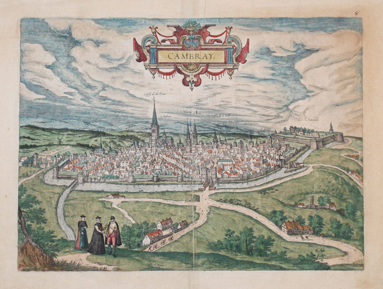
BRAUN (Georg) & HOGENBERG (Frans).
[CAMBRAI] Cambray.
[Cologne, 1588]. 355 x 495 mm.
Referenz des Buchhändlers : LBW-3234
|
|
|
BRAUN (Georg) & HOGENBERG (Frans).
[CANTERBURY] Cantuarbury.
[Cologne, 1588]. 289 x 431 mm.
Referenz des Buchhändlers : LBW-3243

|
|
|
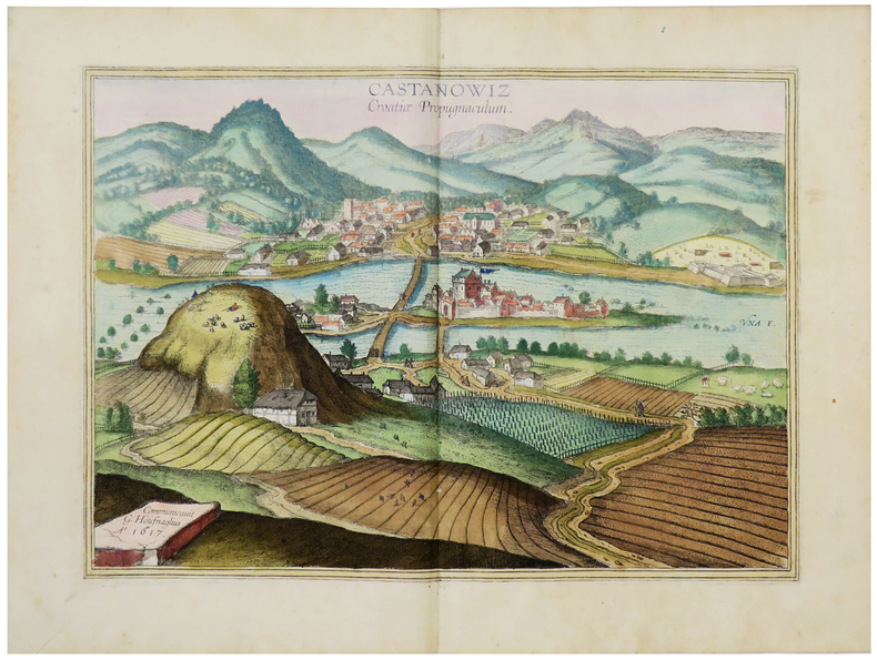
BRAUN (Georg) & HOGENBERG (Frans).
[CROATIE/KOSTANJICA] Castanowiz Croatiæ propugnaculum.
[Cologne], 1617 [1618]. 325 x 449 mm.
Referenz des Buchhändlers : LBW-5913
|
|
|
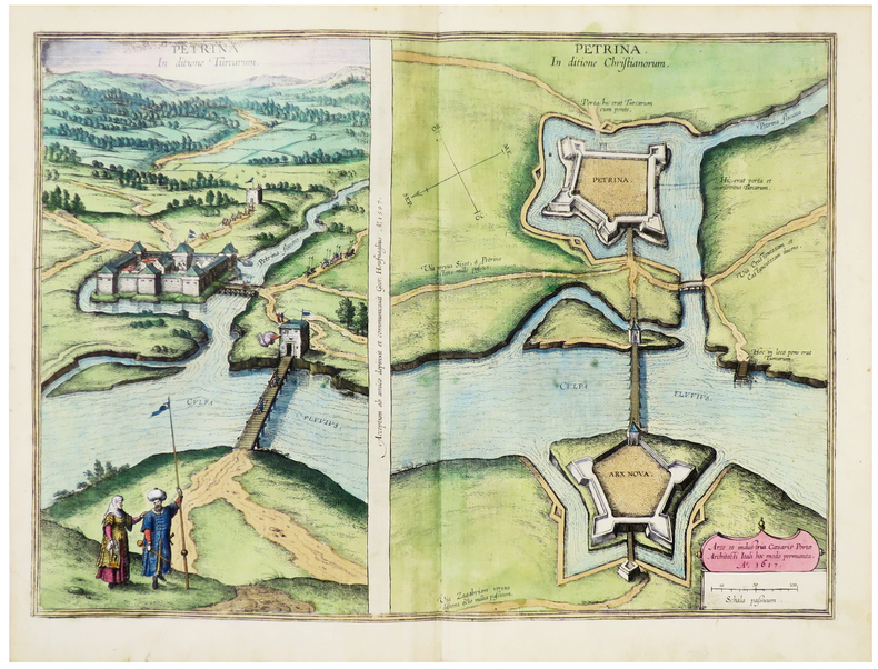
BRAUN (Georg) & HOGENBERG (Frans).
[CROATIE/PETRINJA] Petrina in ditione Turcarum - Petrina in ditione Christianorum.
[Cologne], 1617 [1618]. 364 x 504 mm.
Referenz des Buchhändlers : LBW-5882
|
|
|
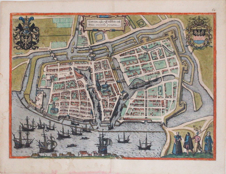
BRAUN (Georg) & HOGENBERG (Frans).
[EMDEN] Emuda, vulgo Embden urbs Frisiæ orientalis primaria.
[Cologne, 1588]. 347 x 486 mm.
Referenz des Buchhändlers : LBW-3306
|
|
|
BRAUN (Georg) & HOGENBERG (Frans).
[GAND] Gandavum, amplissima Flandriæ urbs.
[Cologne, 1572]. 336 x 480 mm.
Referenz des Buchhändlers : LBW-3298

|
|
|
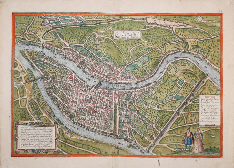
BRAUN (Georg) & HOGENBERG (Frans).
[LYON] Lugdunum.
[Cologne, 1572]. 355 x 495 mm.
Referenz des Buchhändlers : LBW-3233
|
|
|
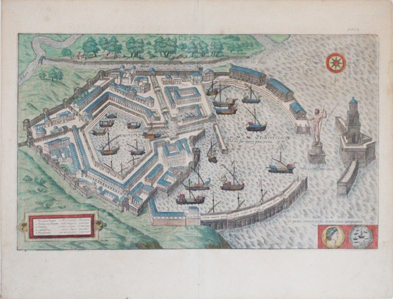
BRAUN (Georg) & HOGENBERG (Frans).
[OSTIE] Ostia.
[Cologne, 1588]. 294 x 496 mm.
Referenz des Buchhändlers : LBW-3307
|
|
|
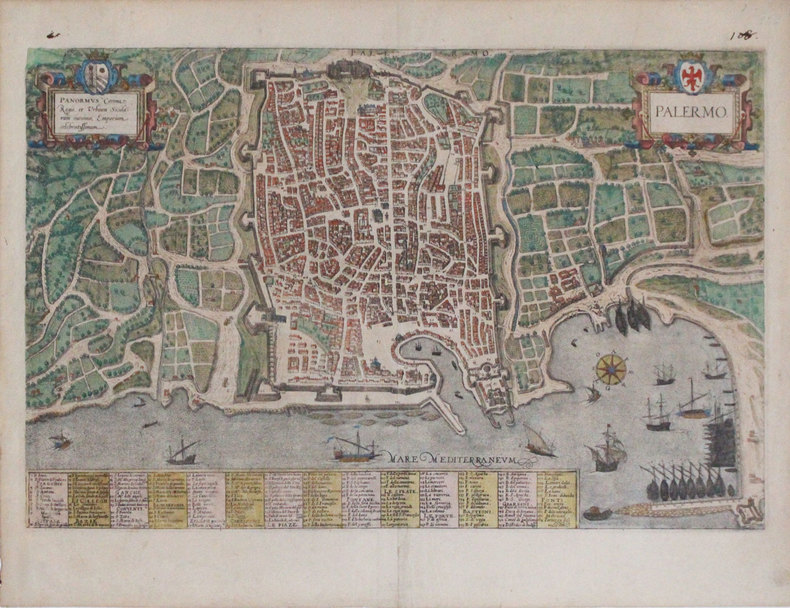
BRAUN (Georg) & HOGENBERG (Frans).
[PALERME] Palermo.
[Cologne, 1588]. 324 x 500 mm.
Referenz des Buchhändlers : LBW-3308
|
|
|
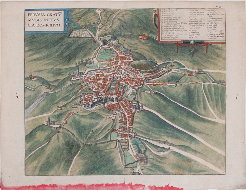
BRAUN (Georg) & HOGENBERG (Frans).
[PÉROUSE] Perusia gratum musis in Tuscia domicilium.
[Cologne, 1588]. 364 x 439 mm.
Referenz des Buchhändlers : LBW-3300
|
|
|
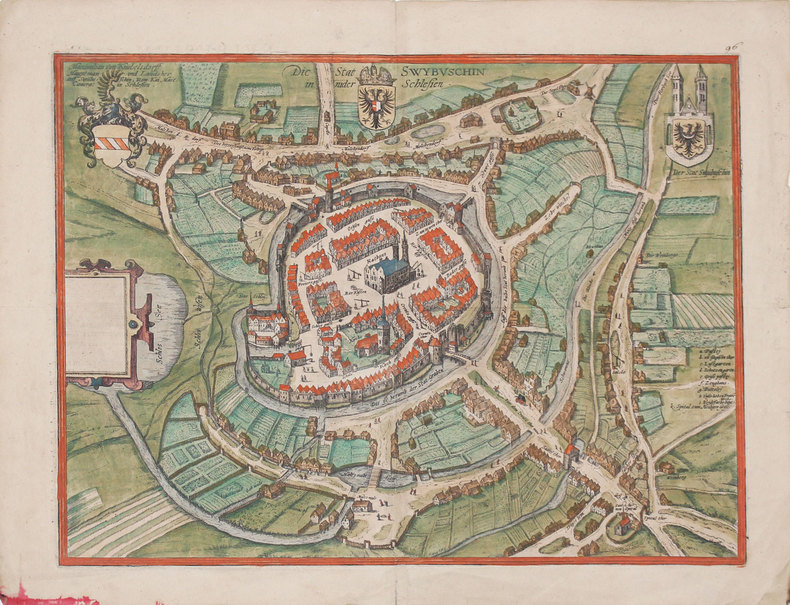
BRAUN (Georg) & HOGENBERG (Frans).
[SWIEBODZIN] Die Stat Swybuschin in nider Schlesien.
[Cologne, 1596-1597]. 341 x 461 mm.
Referenz des Buchhändlers : LBW-3151
|
|
|
BRAUN (Georg) & HOGENBERG (Frans).
Lutetia, vulgari nomine Paris, urbis Galliæ maxima.
[Cologne, 1572]. 339 x 482 mm.
Referenz des Buchhändlers : LBW-8238

|
|
|
BRAUN (Georg);HOGENBERG (Frans);
[COSTUMES] Diversi Dithmarsorum et vicinarum gentium habitus.
Cologne 1598 362 x 495 mm.
Referenz des Buchhändlers : LBW0028b

|
|
|
Braun, [Georg] und [Frans] Hogenberg
Civitas Francofordiana ad M. Altkolorierter Kupferstich.
um 1580. unter Passepartout; Bildausschnitt: 33x47,6 cm; Außenmaß: 47,4x60,6 cm; Mittelfalz, an den Seitenrändern des Blattes zwei ca 1x1,5 cm große gebräunte Stellen (nicht störend), verso lateinischer Text. Ansicht von Frankfurt am Main aus dem ersten Band der sechsbändigen "Civitates orbis terrarum" von Georg Braun und Frans Hogenberg (1572). Blick von Südwesten. Das Straßennetz ist stark vereinfacht, in der Altstadt fälschlich rechtwinklig, die Neustadt flächenmäßig zu klein wiedergegeben. Vorne links drei Figurinen in Landestracht.
Referenz des Buchhändlers : GRAP0192

|
|
|
Braun, Georg (1541-1622) et Hogenberg, Frans (1539?-1590?)
PLAN DE CHARTRES, tiré de l'Atlas : "Civitates orbis terrarum liber primus", Coloniae Agrippinae : [s.n.], 1573
1573 PLAN ANCIEN en couleurs, colorée d'époque à la main, en marron, bleu, vert et rouge. Format total : 40 centimètres de haut par 31 centimètres de large, réalisée par Braun, Georg et Hogenberg, Frans , tiré de l'ATLAS : "Civitates orbis terrarum liber primus", 1573 Coloniae Agrippinae : [s.n.] Editeur,
Referenz des Buchhändlers : 8976
|
|
|
Braun, Georg / Hogenberg, Franz
Beschreibung und Contrafactur der vornembster Stät der Welt.
(Berlin, Coron bei Kindler, 2004). 56 Blatt, 56 Farbtafeln, 15 TextS. (= Coron Exclusiv). Folio. 42,5 cm. Rotbraunes Ganzleder auf 6 imit. Bünden mit reicher Vergoldung und Ganzgoldschnitt.
Referenz des Buchhändlers : 91916

|
|
|
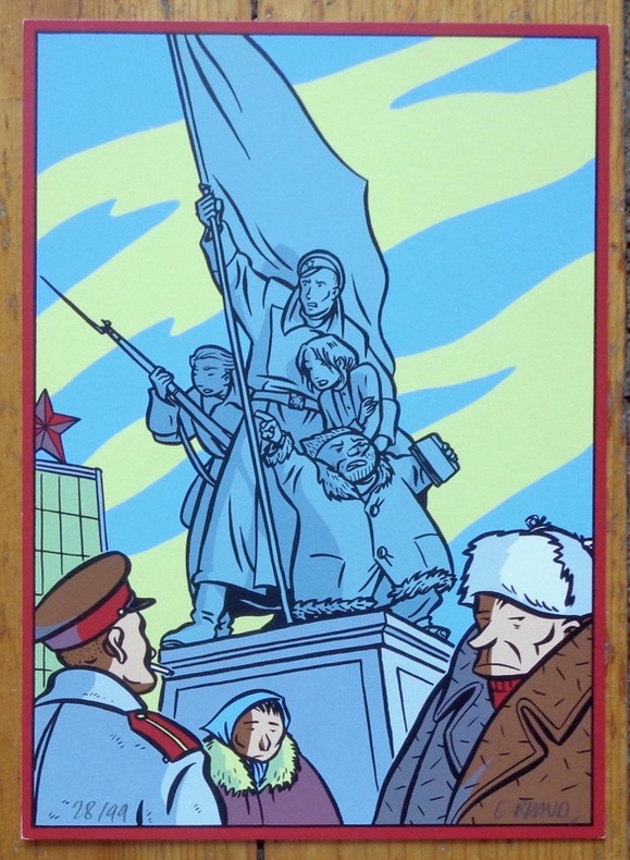
Bravo Emile:
Aleksis Strogonov.
SilkScreen Art. Ex-libris (sérigraphie) au format 15,5 x 22 cm. A l'état de neuf.
Referenz des Buchhändlers : 8461
|
|
|
Breckwoldt, J. J. [Johann Jakob]
Historische Nachrichten über die Elbinsel Altenwerder. Gesammelt und bearbeitet unter Mitwirkung des Lehrers [Gustav] Bosenick.
Harburg, Danckwerts'sche Buchhandlg. C. Sieke [hs. korrigiert "E. Schneider], 1894. 60 TextS. Mit 8 Faltktn. OBrosch.
Referenz des Buchhändlers : 30785

|
|
|
Bredelar:
Bredelar. "Plan der Action welche d. 5. Aug. 1761 zwischen einem Aliirten Hannoverischen und Königl. Französischen Corps bey Bredelar in Westphalen vorgefallen". Schlachtenplan von Bredelar. Kupferstich mit farbigen Truppenaufstellungen aus "Neues Kriegs-Theater ...", 28. Supplement.
Format: 18 x 29,5 cm. *Leicht gebräunt, insgesamt gut erhalten. Landkarten de
|
|
|
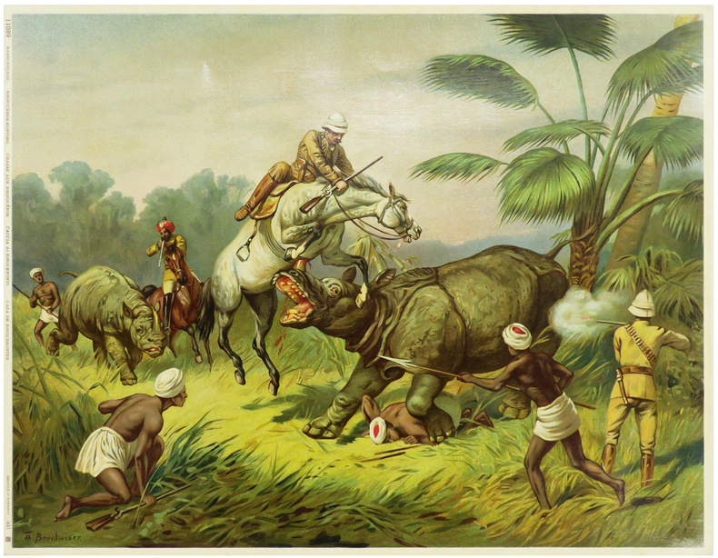
BREIDWISER (Théodore).
[CHASSE au RHINOCÉROS] Chasse aux rhinocéros.
Germany, [circa 1900]. 319 x 416 mm.
Referenz des Buchhändlers : LBW-5968
|
|
|
Breisach:
Alt Breysach eine unvergleichliche Vestung an den rechten Ufer des Ober Rheins in Breißgau gelegen. Altkolorierter Kupferstich.
Format 50 x 58,5 cm. *Großer kolorierter Stadtplan mit Befestigung und den umliegenden Rheinarmen im oberen Teil. Unten mit einer großen Gesamtansicht von Alt Breisach (Ansicht über den Fluß), rechts und links flankiert von je einer allegorischen Darstellung. - Sehr dekoratives Blatt. Sauber und sehr gut erhalten. Landkarten de
|
|
|
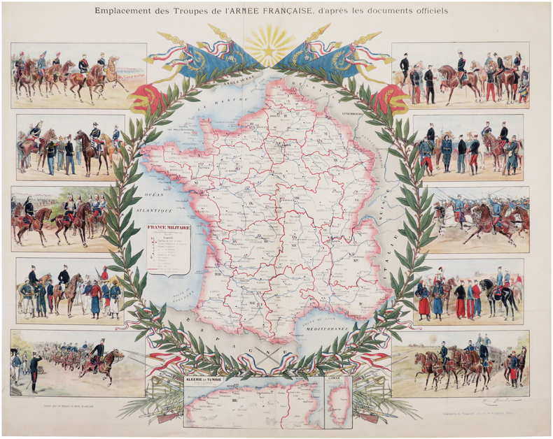
BRESSLER (Henri) & TROPÉ (Henri).
Emplacement des troupes de l'Armée Française, d'après les documents officiels.
Ducourtioux & Huillard, [circa 1895]. Lithographie en couleurs de 507 x 635 mm.
Referenz des Buchhändlers : LBW-7254
|
|
|
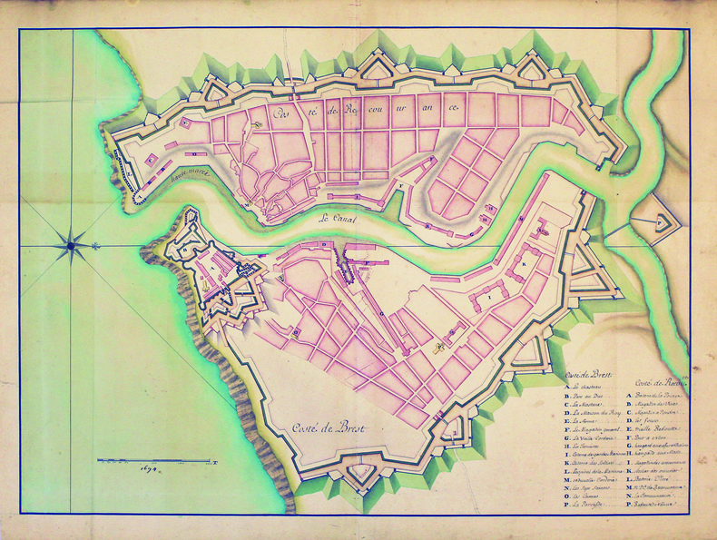
BREST. MANUSCRIT.
[Plan de la ville et du château de Brest].
[circa 1700]. 490 x 640 mm.
Referenz des Buchhändlers : LBW-4186
|
|
|
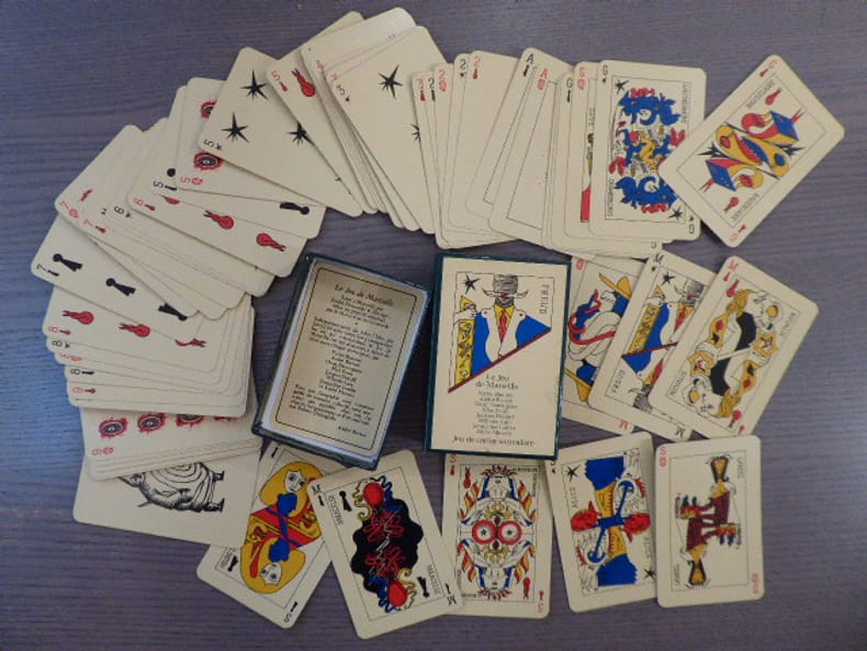
BRETON André - BRAUNER V. - ERNST Max - CHAR R. - DUCHAMP Marcel
LE JEU DE MARSEILLE. - Jeu De Cartes Surréaliste. TAROT des SURREALISTES.
Grimaud - André Dimanche Marseille S.D. (1983) Jeu de 54 cartes ( 90 X 60 mm ) sous coffret illustré en couleurs. Jeu en couleurs édité à Marseille par André Dimanche et fabriqué selon un procédé artisanal par le Maitre-Cartier Grimaud en 1983. créé sur le modèle du tarot de Marseille par les surréalistes présents à la Villa Air-Bel en 1940. Les seize cartes de figures ( indépendamment du joker Ubu, par Jarry ) ont été dessinées, par Arthur Adamov - Victor Brauner - René Char - René Daumal - Robert Delanglade - Oscar Dominguez - Marcel Duchamp - Max Ernst - Jacques Hérold - Sylvain Itkine - Wifredo Lam - André Masson - Benjamin Peret - Tristan Tzara. Les lames d'honneurs représentent Alice, Lautréamont, Freud, Baudelaire, la religieuse Portugaise, Paracelse, Novalis, Pancho Villa, etc. Très bel exemplaire à l'état de neuf bien complet de la petite notice dépliante.
Referenz des Buchhändlers : 462190
|
|
|
Brewer, Leslie
Britain By Road : A Car and Coach Travel Digest
No marks or inscriptions to contents. Slight creasing to front corners, creasing to spine. Very clean very tight pages with slightly dusty boards, small mark to front, a little rubbing to spine and no bumping to corners. 214pp. Routes around Britain for the car traveller using many by-roads to get the traveller to a destination more quickly (1963 style). The book avoids the industrial areas - as these are not 'worthy of recommendation to the tourist' !

|
|
|
BRIAN LE MESSURIER SKETCH MAPS BY F. RODNEY FRASER
Le Messurier Brian : Ggw:Dartmoor33 Warne walking guides
Frederick Warne Publishers Ltd 05/28/1987. Paperback. Used; Good. WE SHIP WITHIN 24 HRS FROM LONDON UK 98% OF OUR ORDERS ARE RECEIVED WITHIN 7-10 DAYS. We believe you will be completely satisfied with our quick and reliable service. All orders are dispatched as swiftly as possible! Buy with confidence! Frederick Warne Publishers Ltd paperback
Referenz des Buchhändlers : 3658718 ISBN : 0723234396 9780723234395
|
|
|
Brian Roberts & Richard Schwadel Illustrated Maps in Red B/W. Paperback with Wild Looking Guy Driving on Cvr with Wild Brown
L.A. Shortcuts: A Guidebook for Drivers Who Hate to Wait Paperback with Wild Looking Guy Driving on Cvr with Wild Brown Eyes Drawn By Perry Van Schelt. Includes Beverly Hills Shortcuts Canyon Shortcuts Downtown Shortcuts Hollywood & Valley Shortc
Red Car Press Los Angeles 1989. Blue SOFTCOVER PBO 1989 Stated 1st Edition 3rd Printing NF/VG SOFTCOVER 7 1/2 X 9 in. Cover light rub wear & tiny chips Edges.213 pgs interior nice tight cleanlight wear. First Edition. Soft Cover. Red Car Press Los Angeles paperback
Referenz des Buchhändlers : 25854 ISBN : 0926055003 9780926055001

|
|
|
BRIAND Pierre-César:
Les jeunes voyageurs en Europe, ou description raisonnée des divers pays compris dans cette partie du monde.
Paris, Lelong, 1823. 5 volumes in-12 de [4]-IV-251; [4]-231; [4]-239; [4]-255-[1]; 292 pages, demi-veau glacé rouge, dos lisse orné de filets et fleurons dorés.
Referenz des Buchhändlers : 19071
|
|
|
Bricker Charles Text and Tooley R. V.Maps
LANDMARKS OF MAPMAKING AN ILLUSTRATED SURVEY OF MAPS AND MAPMAKERS
Elsevier 1968. Hardcover. Good/Good. Hardcover: Linen bound boards with design in gold on lower front board. Title on spine in gold with white/gold printed bands. Top spine edge is frayed through down to board. Corners are lightly bumped. Nice illustrated endpapers. Absolutely fascinating text with gorgeous Fold-out antique map reproductions. Nice tight binding. Color map illustrated dust jacket has edgewear and chipping to corners spine ends and all edges. Lamination is gone from sections of the jacket. Foxed with some soil. Closed tears rubbing. In protective mylar. Elsevier hardcover
Referenz des Buchhändlers : INVENT011918I
|
|
|
BRIE-SERRANT (Clément-Alexandre, marquis de).
[PORNIC] Plan du port et de la rade de Pornic et du canal de communication du dit Pornic avec Nantes.
[1789]. 530 x 882 mm.
Referenz des Buchhändlers : LBW-7944

|
|
|
BRIGHTON.
Plan of Brighton [with comprehensive Street Index]. W. H. Smith's Series of Reduced Ordnance Survey Maps for Tourists by J. Bartholomew. [Scale: 2.5 inches to One Mile.] FINE COPY AND A RARE SURVIVAL
8vo., folding coloured map on cloth measuring 17 x 23 inches (approx. 43 x 59 cms) folding in 18 panels to 6.5 x 4.25 inches (approx. 17 x 11 cms); original limp cloth wrappers printed in red and black, radial corners, a near fine copy. Includes comprehensive street index keyed to map. EXTREMELY SCARCE IN THIS CONDITION.
|
|
|
Brill, Edith
Portrait of the Cotswolds
No marks or inscriptions. A very clean very tight copy with bright unmarked boards, slight foxing to top of page edges and no bumping to corners. Dust jacket price clipped but not marked or creased with small nicks to upper edge and a chip to lower edge. 192pp. Same year reprint of the first edition of Edith Brill's excellent study of the Cotswolds.

|
|
|
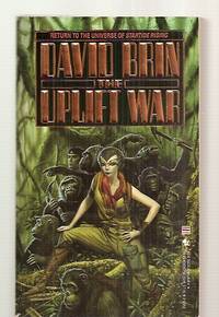
Brin David cover art by Michael Whelan maps by Jaye Zimet
THE UPLIFT WAR
New York: Bantam Books Spectra 1987. Very Good. 1987. First Edition. Mass Market Paperback. 055325121X . First trade edition. Hugo Award winning sequel to STARTIDE RISING. 638 pages. VG copy slight spine cocking cheap text paper starting to tan. . Bantam Books [Spectra] [1987] paperback
Referenz des Buchhändlers : 40527 ISBN : 055325121X 9780553251210
|
|
|
BRION de la TOUR (Louis) & LAVALLÉE (Joseph).
[CORSE] Département du Golo, partie de l'île de Corse – Département de Liamone, partie de l'île de Corse.
[Paris, Brion, 1799]. En deux feuilles de 170 x 215 et 167 x 212 mm.
Referenz des Buchhändlers : LBW-7284

|
|
|
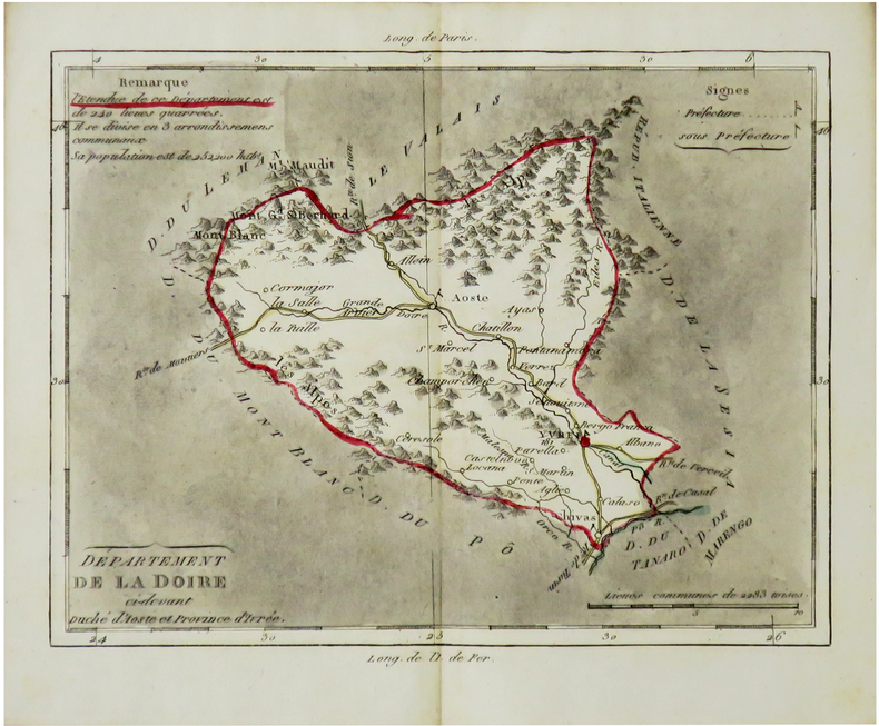
BRION de la TOUR (Louis) & LAVALLÉE (Joseph).
[DOIRE/PIÉMONT] Département de la Doire ci-devant Duché d'Aoste et province d'Ivrée.
[Paris, Brion, 1803]. 170 x 208 mm.
Referenz des Buchhändlers : LBW-7304
|
|
|
BRION de la TOUR (Louis) & LAVALLÉE (Joseph).
[GERS] Département du Gers, ci-devant partie de la Gascogne.
[Paris, Brion, 1798]. 172 x 215 mm.
Referenz des Buchhändlers : LBW-7286

|
|
|
BRION de la TOUR (Louis) & LAVALLÉE (Joseph).
[GIRONDE] Département de la Gironde, ci-devant partie de la Guienne.
[Paris, Brion, 1796]. 223 x 163 mm.
Referenz des Buchhändlers : LBW-7287

|
|
|
 Per e-mail erhalten
 Als pdf-Dokument herunterladen
 RSS feed


