|
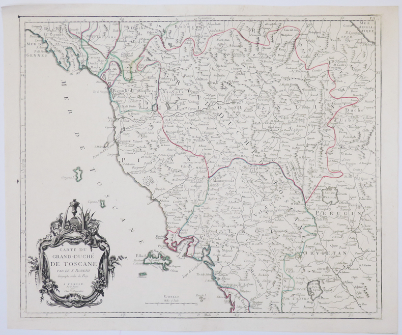
SANTINI (Paolo).
[TOSCANE] Carte du Grand-Duché de Toscane.
Venise, M. Remondini, 1776. 470 x 564 mm.
Referencia librero : LBW-4927
|
|
|
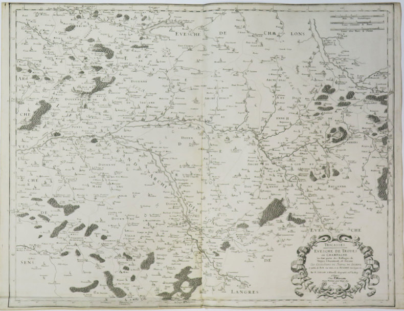
SANSON d'ABBEVILLE (Nicolas).
[TROYES] Tricasses. Evesché de Troyes en Champagne où sont partie des balliages de Troyes, Chaumont, et Sézane.
Paris, P. Mariette, 1656. 430 x 544 mm.
Referencia librero : LBW-3638
|
|
|
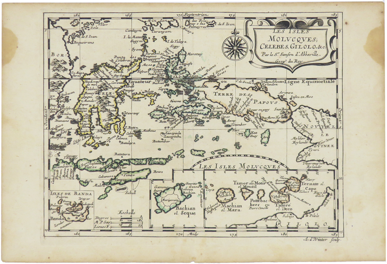
SANSON d'ABBEVILLE (Nicolas).
[ÎLES MOLUQUES] Les isles Molucques, Célèbes, Gilolo, &c.
[Paris, circa 1680]. 187 x 245 mm.
Referencia librero : LBW-5478
|
|
|
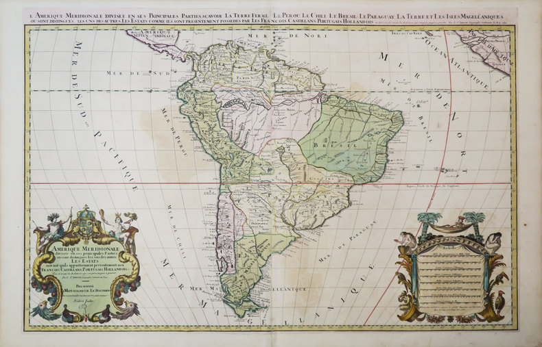
SANSON d'ABBEVILLE (Nicolas) & JAILLOT (Hubert).
Amérique méridionale divisée en ses principales parties où sont distingués les uns des autres les estats suivant qu'ils appartiennent présentement aux François, Castillans, Portugais, Hollandois, &c.
Paris, H. Jaillot, 1691. En deux feuilles jointes de 573 x 884 mm.
Referencia librero : LBW-3673
|
|
|
SANSON d'ABBEVILLE (Nicolas);
Audience de Guatimala.
1683 182 x 276 mm.
Referencia librero : LBW-697

|
|
|
SANSON d'ABBEVILLE.
Baillage de Mascon en Bourgogne, Evesché de Mascon.
1659 Limites aquarellées. 1 carte gravée sur cuivre, 43 x 53 cms. P. Sanson 1659
Referencia librero : 12214
|
|
|
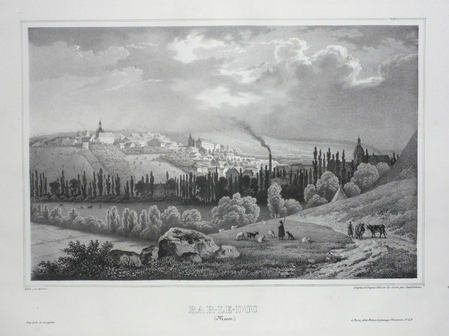
SANDMANN;
BAR-LE-DUC (Meuse).
Paris Benard circa 1850 222 x 295 mm.
Referencia librero : LBW03d58
|
|
|
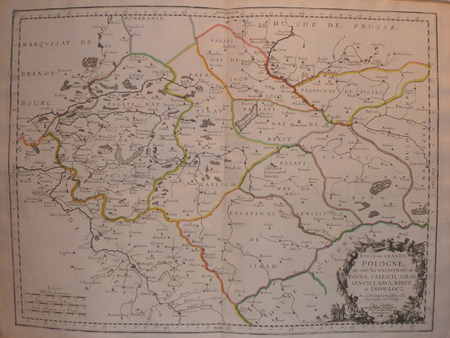
SANSON d'ABBEVILLE (Nicolas);
Basse ou Grande Pologne où sont les palatinats de Posna, Calisch, Sirad, Lencici, Rava, Brest, et Inowlocz.
Paris chez l'autheur 1703 417 x 560 mm.
Referencia librero : LBW02524
|
|
|
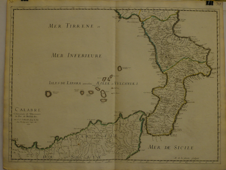
SANSON d'ABBEVILLE (Nicolas);
Calabre citérieure et ultérieure, le far de Messine &c.
1648 409 x 558 mm.
Referencia librero : LBW-969
|
|
|
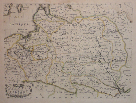
SANSON d'ABBEVILLE (Nicolas);
Estats de la couronne de Pologne.
Paris chez l'autheur 1657 191 x 253 mm.
Referencia librero : LBW0418d
|
|
|
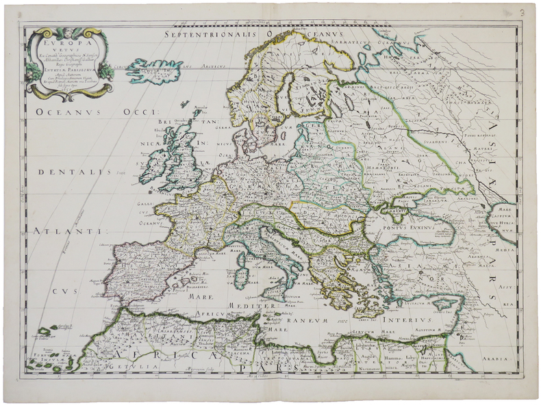
SANSON d'ABBEVILLE (Nicolas).
Europa vetus.
Paris, chez l'auteur et chez Pierre Mariette, 1650. 393 x 553 mm.
Referencia librero : LBW-4944
|
|
|
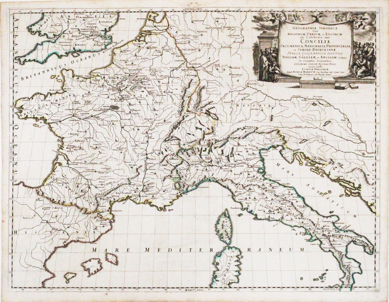
SANSON d'ABBEVILLE (Nicolas).
Geographia synodica sive regionum, urbium, et locorum, ubi celebrata sunt Concilia œcumenica, nationalia, provincialia, et synodi diœcesanæ tabula geographica secunda Italiam, Galliam, et Angliam.
Paris, Pierre Mariette, 1667. 422 x 554 mm.
Referencia librero : LBW-3266
|
|
|
SANDS M. Et Mme H. et BOLAND Henri
Guides-Joanne : Angleterre , Écosse , Irlande . Complet De Sa Carte Indépendante En Fin D'ouvrage
Paris - Londres - New York Hachette & Cie 1908 In 16 Collection " Des Guides-Joanne " avec 7 plans et 10 cartes en couleurs dont certaines dépliantes . Nombreuses publicités , notamment d'hôtels mais aussi de Michelin , de chocolat Menier etc . Illustré de photographies en noir et blanc .- 190 p. + 152 p. , 450 gr.
Referencia librero : 015241

|
|
|
SANSON d'ABBEVILLE (Nicolas);
Isle et royaume de Candie.
Paris chez l'autheur 1670 circa 393 x 552 mm.
Referencia librero : LBW-587
|
|
|
SANSON d'ABBEVILLE (Nicolas).
Isle et royaume de Sicile.
Paris, Pierre Mariette, 1663. 382 x 560 mm.
Referencia librero : LBW-657

|
|
|
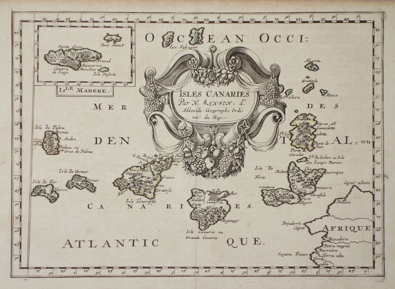
SANSON d'ABBEVILLE (Nicolas).
Isles Canaries.
1683. 189 x 265 mm.
Referencia librero : LBW-705
|
|
|
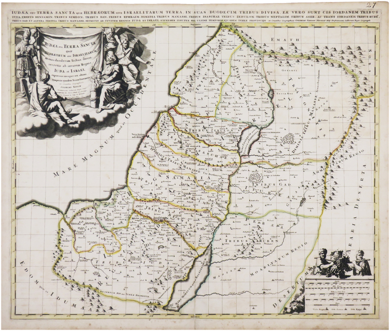
SANSON (Guillaume).
Judæa seu Terra Sancta quæ Hebræorum sive Israelitarum in suas duodecim tribus divisa.
Amsterdam, Pierre Schenk, [circa 1700]. 487 x 577 mm.
Referencia librero : LBW-8050
|
|
|
SANSON d'ABBEVILLE (Nicolas).
L'Afrique, ou Lybie ultérieure où sont le Saara, ou Désert, le Pays des Nègres, la Guinée, et les pays circonv.
Paris, Pierre Mariette, 1655. 342 x 547 mm.
Referencia librero : LBW-7677

|
|
|
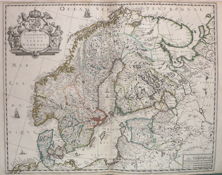
SANSON d'ABBEVILLE (Nicolas);
La Scandinavie où sont les estats de Suède, Norwègue et Danemarck.
Paris P. Mariette 1658 421 x 525 mm.
Referencia librero : LBW0394d
|
|
|
SANSON d'ABBEVILLE (Nicolas);
Le Brésil.
1683 197 x 269 mm.
Referencia librero : LBW-698
|
|
|
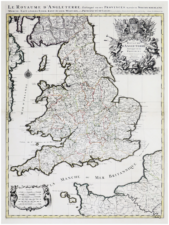
SANSON d'ABBEVILLE (Nicolas) & JAILLOT (Alexis-Hubert).
Le Royaume d'Angleterre distingué en ses provinces.
Paris, H. Jaillot, 1693. En deux feuilles jointes formant une carte de 785 x 584 mm.
Referencia librero : LBW-6390
|
|
|
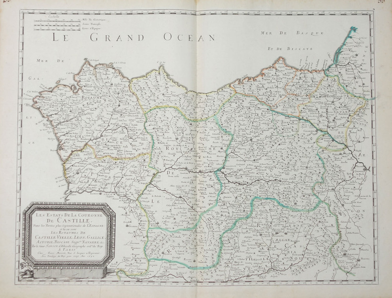
SANSON d'ABBEVILLE (Nicolas).
Les Estats de la couronne de Castille, dans les parties plus septentrionales de l'Espagne.
Paris, Pierre Mariette, 1652. 404 x 533 mm.
Referencia librero : LBW-656
|
|
|
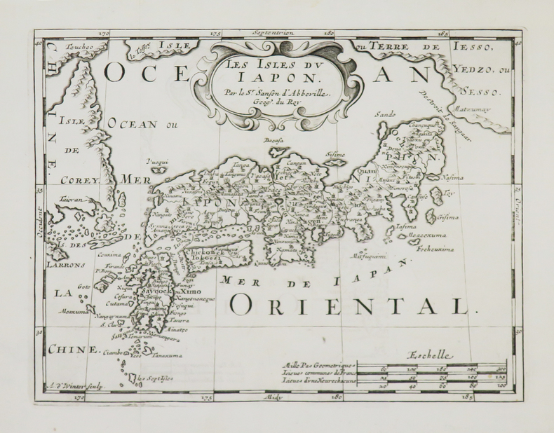
SANSON d'ABBEVILLE (Nicolas).
Les Isles du Japon.
[1700]. 185 x 239 mm.
Referencia librero : LBW-4948
|
|
|
SANDMANN;
LILLE (Nord).
Paris Benard circa 1850 225 x 292 mm.
Referencia librero : LBW03d78
|
|
|
SANDMANN.
MELUN (Seine et Marne).
Paris, Benard, [circa 1850]. 212 x 298 mm.
Referencia librero : LBW03d75
|
|
|
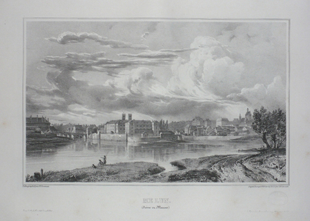
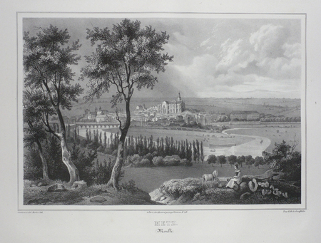
SANDMANN;
METZ (Moselle).
Paris Benard circa 1850 224 x 292 mm.
Referencia librero : LBW03d4f
|
|
|
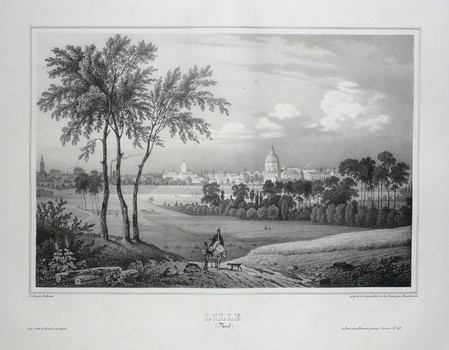
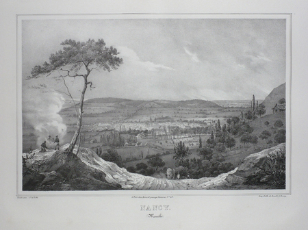
SANDMANN;
NANCY (Meurthe).
Paris Benard circa 1850 218 x 293 mm.
Referencia librero : LBW03d4e
|
|
|
SANDEMANN;
ORLEANS (Loiret).
Paris Benard circa 1850 216 x 295 mm.
Referencia librero : LBW03d6b

|
|
|
SANSON d'ABBEVILLE (Nicolas);
Partie septentrionale du royaume de Hongrie, tirée de divers autheurs.
Paris chez l'autheur 1699 361 x 580 mm.
Referencia librero : LBW006af

|
|
|
SANSON d'ABBEVILLE (Nicolas).
Partie de l'Inde au delà du Gange - Presqu'isle de l'Inde au delà du Gange.
1652. 188 x 251 mm.
Referencia librero : LBW04196
|
|
|
SANTINI (Paolo).
Partie des gouvernemens d'Astrakhan et de Woronez : le Kabarda et partie du païs des cosaques du Don et du Jaik.
Venise, Remondini, 1778. 437 x 549 mm.
Referencia librero : LBW-2638

|
|
|
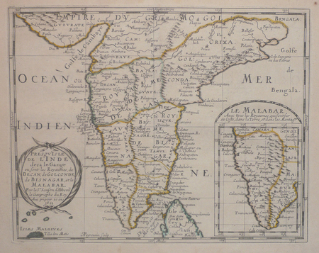
SANSON d'ABBEVILLE (Nicolas);
Presqu'isle de l'Inde deça le Gange où sont les royaumes de Decan, de Golconde, de Bisnagar, et le Malabar.
1652 192 x 243 mm.
Referencia librero : LBW04197
|
|
|
sans nom
PUZZLE VINTAGE LAROUSSE DU XXEME SIECLE carte n°32 EUROPE et n°33 AFRIQUE
Larousse, 1950 environ, boite en bon état ( arêtes des coins frottées) contenant 2 puzzles en bois: l'Afrique et l'Europe. Ce sont les cartes du Larousse du XXeme siecle. Les puzzles sont en excellent état, et complets.
Referencia librero : 8820
|
|
|
SANSON d'ABBEVILLE (Nicolas) & COVENS (Jean) & MORTIER (Pierre).
Romani imperii qua occidens est, descriptio geographica.
Amsterdam, J. Covens et C. Mortier, [circa 1720]. 400 x 501 mm.
Referencia librero : LBW-464
|
|
|
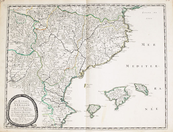
SANSON d'ABBEVILLE (Nicolas);
Royaume d'Arragon divisé en sept dioecèses.
1663 417 x 378 mm.
Referencia librero : LBW-948
|
|
|
SANDMANN;
STRASBOURG (Bas-Rhin).
Paris Benard circa 1850 217 x 294 mm.
Referencia librero : LBW03d4d

|
|
|
Sanborn Anne Fay; Maps Illustrator
Transylvania and the Hungarian-Rumanian Problem: A Symposium Compiled by the Danubian/Research and Information Center. Ed by Anne Fay Sanborn
Danubian Pr 1979-09-01. Hardcover. Very Good. Hardcover no marks noted in text no dj cover stainedAND AS ALWAYS SHIPPED IN 24 HOURS; and emailed to you a USPS tracking number on all orders; all books are sanitized and cleaned for your protection before mailing Danubian Pr hardcover
Referencia librero : 121120020 ISBN : 0879340215 9780879340216
|
|
|
Sanborn Anne Fay; Maps Illustrator
Transylvania and the Hungarian-Rumanian Problem: A Symposium Compiled by the Danubian/Research and Information Center. Ed by Anne Fay Sanborn
Danubian Pr 1979-09-01. Hardcover. Very Good. Hardcover with dj no marks noted in textAND AS ALWAYS SHIPPED IN 24 HOURS; and emailed to you a USPS tracking number on all orders; all books are sanitized and cleaned for your protection before mailing Danubian Pr hardcover
Referencia librero : 121120024 ISBN : 0879340215 9780879340216
|
|
|
Sanderson Ivan T. chapter head drawings by F. Enderoth Saunders maps and charts by the author Dust Wrapper design by Samuel H.
FOLLOW THE WHALE
Boston: Little Brown and Company 1956. Fair in Fair dust jacket. 1956. First Edition. Hardcover. First edition stated. "From time immemorial man has pursued the whale. This is the story of the peoples who have engaged in that pursuit---its historical cultural and economic consequences". 423 pages illustrated with maps including the endpapers charts and drawings general whaling chronology note on maps appendixes bibliography by periods and subjects index. Otherwise VG copy light wear very light bumping to some corners with owner's name and date to the front free endpaper and pencil annotations to the margins of a dozen or two pages scattered throughout the book in worn/torn/chipped especially to the spine head/etc Good at best Dust Wrapper. . Little Brown and Company [1956] hardcover
Referencia librero : 53121

|
|
|
SANDRART Joachim von (Francoforte 1606 - Norimberga 1688)
Recentis Romae Ichonographia ...
Grande pianta della città, stampata su due fogli reali, copia di quella realizzata da Giovan Battista Falda nel 1667 per papa Alessandro VII. Pianta a proiezione mista, orientata con il nord a sinistra. Topograficamente la carta del Sandrart è fedele a quella del Falda; le modifiche sostanziali sono nei cartigli, con le scritte in tedesco, e nella dedica a papa Innocenzo XI. Il cartiglio di destra raffigura gli stemmi dei Rioni, mentre in basso al centro sono incise delle piccole vedute delle sette chiese giubilari. Incisa a quattro mani con Johannes Meyer, questa pianta risulta per l’eleganza del segno, più raffinata rispetto al Falda, intagliata dal francese Lhuiler. "Copia della pianta piccola del Falda incisa dal Meyer che si firma in basso a sinistra Iohann Meyer fecit Tiguri. IN alto a sinistra, in luogo della dedica fatta dal Falda ad Alessandro VII, compare quella ad Innocenzo XI (1676-89) con la data 1677 e più in basso il nome di Ioachini Sandrart. La pianta è probabilmente anche contenuta nell'opera del Sandrart Der Alten und neue, pubblicata a Norimberga nel 1768" (cfr. Marigliani p. 219). Acquaforte, con margini, in eccellente stato di conservazione. Rara. Large plan of the city, printed on two real sheets, copy of the one made by Giovan Battista Falda in 1667 for Pope Alexander VII. Mixed projection map, oriented with north on the left. Topographically, Sandrart's map is faithful to Falda's; the substantial changes are in the cartouches, with the German inscriptions, and in the dedication to Pope Innocezo XI. The right-hand cartouche depicts the coats of arms of the Rioni, while small views of the seven Jubilee churches are engraved in the bottom centre. Engraved by four hands with Johannes Meyer, this plan is more refined in the elegance of its sign than the Falda, carved by the Frenchman Lhuiler. "Copy of Falda's small plan engraved by Meyer, signed at lower left Iohann Meyer fecit Tiguri. In the upper left corner, instead of the dedication made by Falda to Alexander VII, the dedication to Innocent XI (1676-89) appears with the date 1677 and lower down the name of Ioachini Sandrart. The plan is probably also contained in Sandrart's work Der Alten und neue, published in Nuremberg in 1768' (cf. Marigliani p. 219). Sandrart carved this plan together with Johannes Meyer; the result is a far more refained work compared to that of Falda, carved by Lhuiler. Etching, with margins, in excellent condition. Rare. Huelsen (1915): n. 119; Scaccia Scarafoni (1939): n. 200; A. P. Frutaz, "Le piante di Roma", CLVI ; TIB p. 317, 281 C1. C. Marigliani, "Le Piante di Roma delle collezioni private", tav. 126.

|
|
|
SANDS M. Et Mme H. et BOLAND Henri
Guides-Joanne : Angleterre , Écosse , Irlande . Complet De Sa Carte Indépendante En Fin D'ouvrage
Collection " Des Guides-Joanne " avec 7 plans et 10 cartes en couleurs dont certaines dépliantes . Nombreuses publicités , notamment d'hôtels mais aussi de Michelin , de chocolat Menier etc . Illustré de photographies en noir et blanc .- 190 p. + 152 p. , 450 gr.

|
|
|
Sanson Nicolas Pugsley William H. William Howard donor WH. Pugsley Collection of Early Canadian Maps W. H.
Le Canada ou Nouvelle France &c. : tiree de diverses relations des Francois Anglois Hollandois &c. 1667 Leather Bound
2019. Leather Bound. New. Leather Binding on Spine and Corners with Golden Leaf Printing on round Spine extra customization on request like complete leather Golden Screen printing in Front Color Leather Colored book etc. Reprinted in 2019 with the help of original edition published long back 1667. This book is printed in black & white sewing binding for longer life Printed on high quality Paper re-sized as per Current standards professionally processed without changing its contents. As these are old books we processed each page manually and make them readable but in some cases some pages which are blur or missing or black spots. If it is multi volume set then it is only single volume if you wish to order a specific or all the volumes you may contact us. We expect that you will understand our compulsion in these books. We found this book important for the readers who want to know more about our old treasure so we brought it back to the shelves. Hope you will like it and give your comments and suggestions. Lang: - freeng. EXTRA 10 DAYS APART FROM THE NORMAL SHIPPING PERIOD WILL BE REQUIRED FOR LEATHER BOUND BOOKS. COMPLETE LEATHER WILL COST YOU EXTRA US$ 25 APART FROM THE LEATHER BOUND BOOKS. hardcover
Referencia librero : LB1111007010808
|
|
|
Sanson Nicolas Pugsley William H. William Howard donor WH. Pugsley Collection of Early Canadian Maps W. H.
Le Canada ou Nouvelle France &c. : tiree de diverses relations des Francois Anglois Hollandois &c. 1667 FULL LEATHER BOUND
2019. SUPER DELUXE EDITION. New. Antique look with Golden Leaf Printing and embossing with round Spine completely handmade bindingextra customization on request like Color Leather Colored book special gold leaf printing etc. Reprinted in 2019 with the help of original edition published long back 1667. This book is printed in black & white sewing binding for longer life Printed on high quality Paper re-sized as per Current standards professionally processed without changing its contents. As these are old books we processed each page manually and make them readable but in some cases some pages which are blur or missing or black spots. If it is multi volume set then it is only single volume if you wish to order a specific or all the volumes you may contact us. We expect that you will understand our compulsion in these books. We found this book important for the readers who want to know more about our old treasure in old look so we brought it back to the shelves. Hope you will like it and give your comments and suggestions. Lang: - freeng. EXTRA 10 DAYS APART FROM THE NORMAL SHIPPING PERIOD WILL BE REQUIRED. Normal Hardbound Edition is also available on request. unknown
Referencia librero : SD1111007010808
|
|
|
Sanson Nicolas Pugsley William H. William Howard donor WH. Pugsley Collection of Early Canadian Maps W. H.
Le Canada ou Nouvelle France &c. : tiree de diverses relations des Francois Anglois Hollandois &c. 1667
2019. Paperback. New. Lang: - freeng. Reprinted in 2019 with the help of original edition published long back 1667. This book is Printed in black & white sewing binding for longer life with Matt laminated multi-Colour Soft Cover HARDCOVER EDITION IS ALSO AVAILABLE Printed on high quality Paper re-sized as per Current standards professionally processed without changing its contents. As these are old books we processed each page manually and make them readable but in some cases some pages which are blur or missing or black spots. If it is multi volume set then it is only single volume if you wish to order a specific or all the volumes you may contact us. We expect that you will understand our compulsion in these books. We found this book important for the readers who want to know more about our old treasure so we brought it back to the shelves. Any type of Customisation is possible with extra charges. Hope you will like it and give your comments and suggestions. paperback
Referencia librero : PB1111007010808
|
|
|
Sanson Nicolas Pugsley William H. William Howard donor WH. Pugsley Collection of Early Canadian Maps W. H.
Le Canada ou Nouvelle France &c. : tiree de diverses relations des Francois Anglois Hollandois &c. 1667 Hardcover
2019. Hardcover. New. Lang: - freeng. Reprinted in 2019 with the help of original edition published long back 1667. This book is Printed in black & white Hardcover sewing binding for longer life with Matt laminated multi-Colour Dust Cover Printed on high quality Paper re-sized as per Current standards professionally processed without changing its contents. As these are old books we processed each page manually and make them readable but in some cases some pages which are blur or missing or black spots. If it is multi volume set then it is only single volume if you wish to order a specific or all the volumes you may contact us. We expect that you will understand our compulsion in these books. We found this book important for the readers who want to know more about our old treasure so we brought it back to the shelves. Any type of Customisation is possible with extra charges. Hope you will like it and give your comments and suggestions. hardcover
Referencia librero : 1111007010808
|
|
|
SANZ, Carlos.
Cartografía histórica de los Descubrimientos Australes.
Madrid, Publicaciones de la Real Sociedad Geográfica, 1967. 4to. mayor; 96 pp., con 82 reproducciones de mapas a toda plana, tres de ellos plegados. Cubiertas originales

|
|
|
SAONE ET LOIRE
Carte d?partementale couleurs au 1/200 000e. D?but XXe.
Une feuille repli?e. 80 x 60 cm.
|
|
|
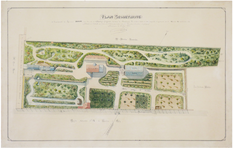
SARRAZIN (E. C.).
[DOUBS] Plan géométrique de la propriété de Monsieur Bossy, sise lieu-dit à Champ-Forgeron, territoire de Besançon.
1875. 45 x 70 cm ; monté sur carton fort.
Referencia librero : LBW-7429
|
|
|
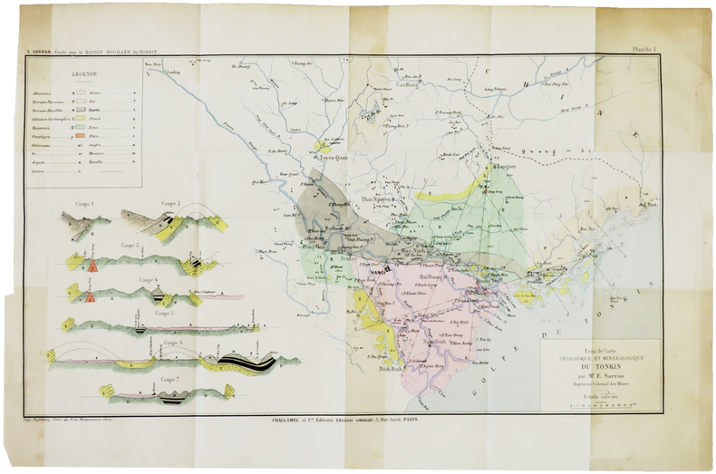
SARRAN (Émile).
[GÉOLOGIE/TONKIN] Essai de carte géologique et minéralogique du Tonkin.
[1888]. 243 x 433 mm.
Referencia librero : LBW-5005
|
|
|
SARTIAUX Félix
Villes Mortes D'Asie Mineure Pergame, Ephese, Priene, Milet, Le Didymeion, Hierapolis.
1911 à Paris , chez Hachette , in-8 (200x130),relié pleine toile ,233pp avec 40 vues photographiques Hors texte prises par l'auteur ,3 reproductions de monuments, 8 cartes et plans .
Referencia librero : PHO-926
|
|
 Recibir por correo electrónico
 Descargar en documento PDF
 Flujo RSS


