|
s. l.d. d'Annemie Buffels. Avec une introduction de Willem Elias
Kunst van het Spel , 75 jaar Nationale Loterij
Bruxelles, Fonds Mercator/ Mercatorfonds , 2009 Hardback, 280x240mm, 224p, Dutch (NL) edition ISBN 978906153911713.
Referenz des Buchhändlers : 23416
|
|
|
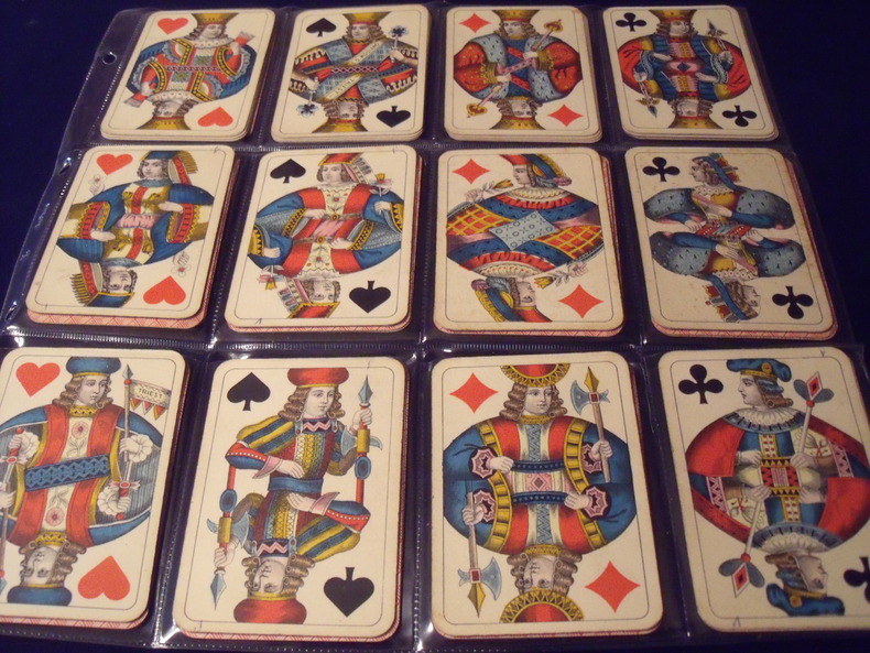
S.D.MODIANO ://:
WIENER BILD.
Wiener Bild.Portrait Viennois. Jeu Des Couronnes.Kaffée Haus KARTEN.(cartes des maisons de café.)type A. 52cartes.complet.1906.Fabricant:SD.ModianoTriest.Italie.Trés bon état .Sans boite.
Referenz des Buchhändlers : 0631906
|
|
|
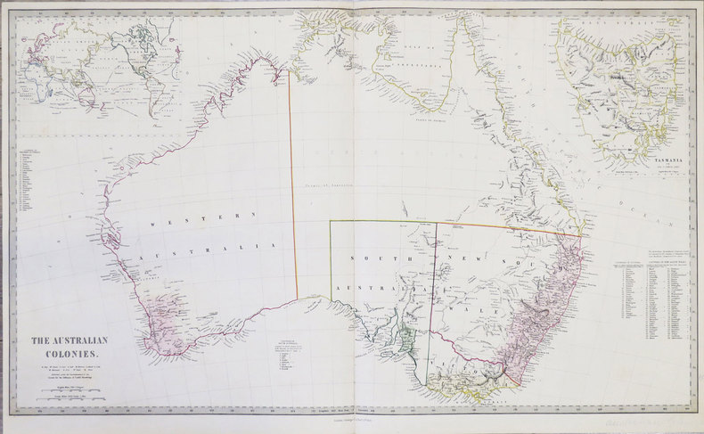
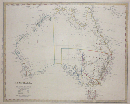
S.D.U.K.
[AUSTRALIE] The Australian colonies.
London, George Cox, 1853. 405 x 684 mm.
Referenz des Buchhändlers : LBW-855
|
|
|
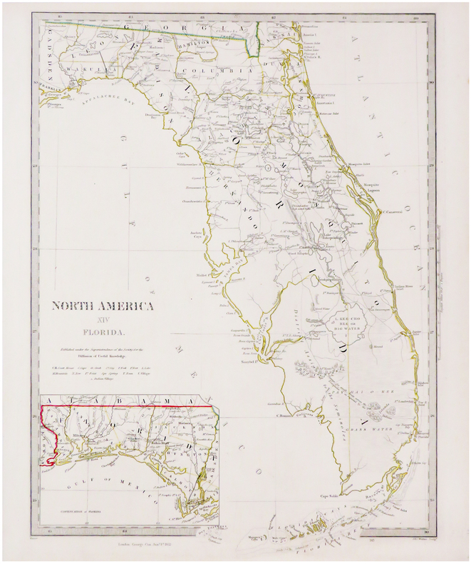
S.D.U.K.
[FLORIDE] North America XIV Florida.
London, George Cox, 1852. 410 x 312 mm.
Referenz des Buchhändlers : LBW-3494
|
|
|
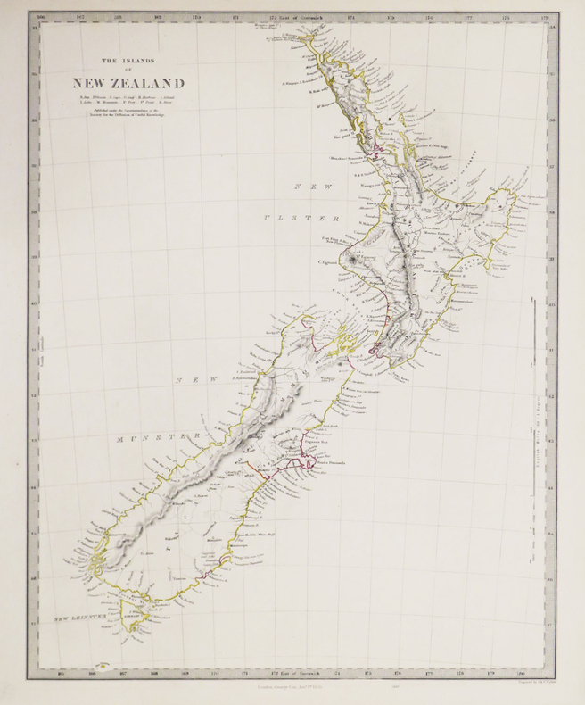
S.D.U.K.
[NOUVELLE-ZÉLANDE] The Islands of New Zealand.
London, George Cox, 1853. 400 x 310 mm.
Referenz des Buchhändlers : LBW-3418
|
|
|
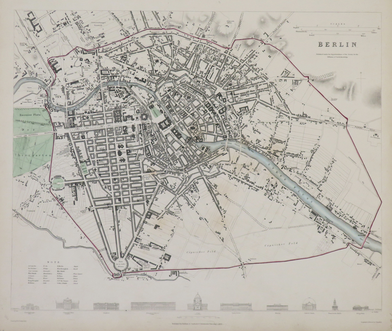
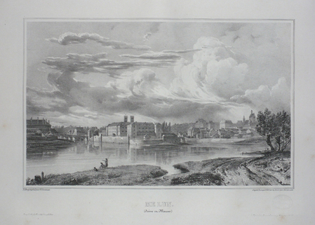
S.D.U.K.
Berlin.
Londres, Baldwin & Cradock, 1833. 310 x 365 mm.
Referenz des Buchhändlers : LBW-4317
|
|
|
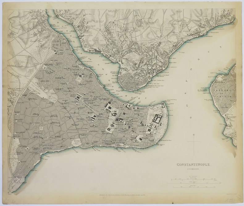
S.D.U.K.
Constantinople. Stambool.
Londres, 1840. 320 x 391 mm.
Referenz des Buchhändlers : LBW-3552
|
|
|
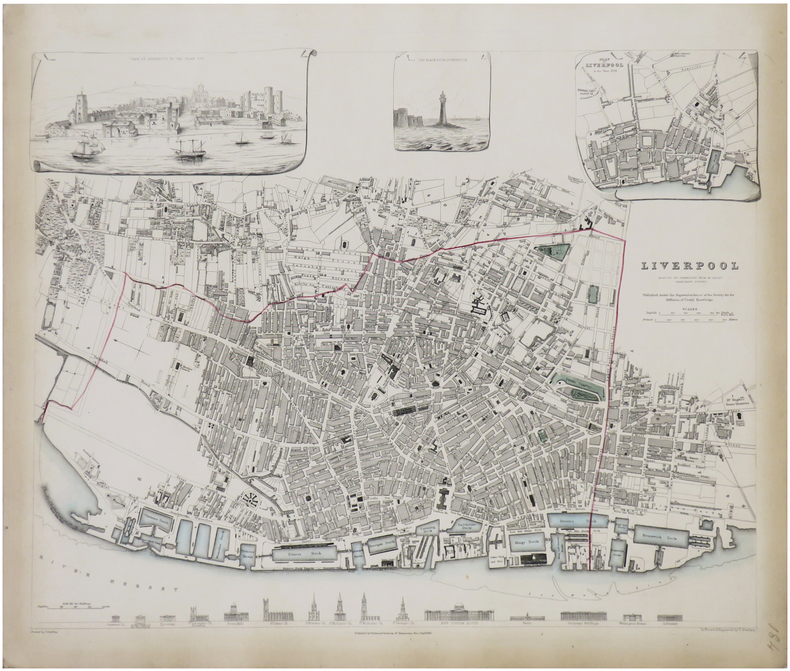
S.D.U.K.
Liverpool reduced by permission from Mr. Gage's elaborate survey.
Londres, Baldwin & Cradock, 1836. 380 x 385 mm.
Referenz des Buchhändlers : LBW-1765
|
|
|
S.D.U.K.;
[AUSTRALIE] Australia.
Londres Society for the Diffusion of Useful Knowledge 1853 317 x 395 mm.
Referenz des Buchhändlers : LBW0072b
|
|
|
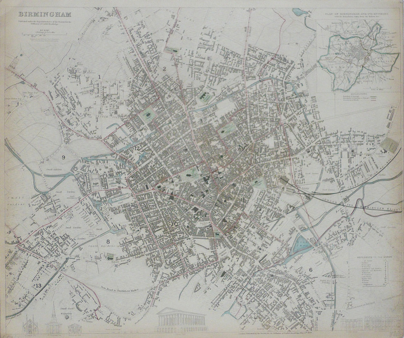
S.D.U.K.;
Birmingham.
Londres Society for the Diffusion of Useful Knowledge 1839 332 x 403 mm.
Referenz des Buchhändlers : LBW-1767
|
|
|
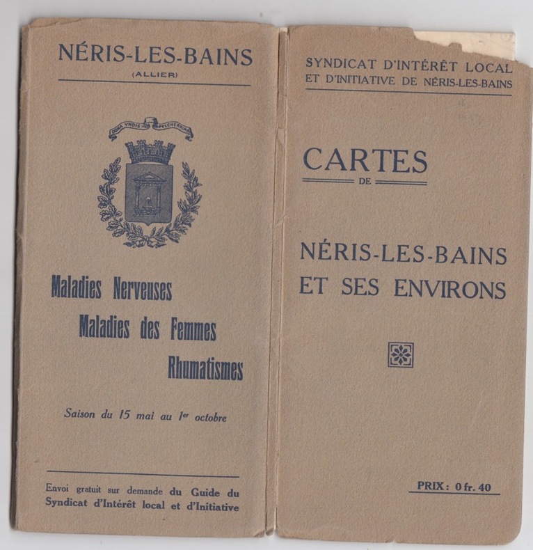
S.I.- Neris les bains
Cartes de Neris les bains et ses environs
S.I.- Neris les bains, grandes cartes dépliantes,texte au dos,rare
Referenz des Buchhändlers : 25585
|
|
|
Saalfeld:
Saalfeld. "Plan des Marches einiger Königl. Preussischen Trouppen nach Salfeld und der dabey vorgefallenen Gefangennehmung zweyer Bataillons der combinirten Reichs-Armee, d. 2. April 1761". Schlachtenplan von Saalfeld. Kupferstich mit farbigen Truppenaufstellungen aus "Neues Kriegs-Theater ...", No. 38.
Format: 18 x 29,5 cm. *Leicht gebräunt, insgesamt gut erhalten. Landkarten de
|
|
|
SAARBRUCKEN
Carte d'Etat-Major au 1/200 000?. Fin XIXe.
1 feuille repli?e. 32x49 cm.
|
|
|
Saccone, Richard
Travel Korea Your Way
213 pages including index. Describes over 60 of the most popular attractions Korea has to offer. Includes over 160 spectacular color photos and 20 informative maps. Provides everything you need to plan a wonderful vacation in Korea. Price clipped from flap of back cover. Minimal traces of wear. Tiny rubber date stamp upon bottom edge of textblock. Book
|
|
|
Sack Manfred
Playgirls d'Antan
Duculot In-12°, 171 pages, bel ouvrage orné de 77 clichés à pleine page au format carte postale en noir et en couleurs.
Referenz des Buchhändlers : 9183
|
|
|
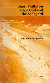
Sadlier Paul & Ruth; photos & maps by the authors Illustrator
SHORT WALKS ON CAPE COD AND THE VINEYARD Paperback Jan 01 1976 Sadlier .
The Pequot Press 1976-01-01. Paperback. Very Good. Prompt reliable service mailed next business dayThe Pequot Press 1975 stated first edition paperback signed by both authors on half-title fine wrapper smooth spine tight binding clean unmarked text Prompt reliable service shipped next business day. Int'l mailed via first class or priority. The Pequot Press paperback
Referenz des Buchhändlers : SpNF122159
|
|
|
SAGANSAN (L.).
Plan de Paris.
1866. En 32 sections montées sur toile et pliées, formant une carte de 0,80 x 1,14 m ; étiquette de l'éditeur Lanée au dos de la carte ; sous étui de papier marbré.
Referenz des Buchhändlers : LBW-5780
|
|
|
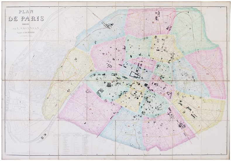
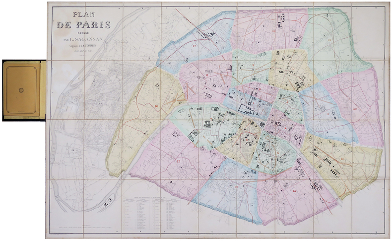
SAGANSAN (L.).
Plan de Paris.
Paris, chez l'auteur, 1860. En 36 sections montées sur toile et pliées, formant un plan de 0,79 x 1,14 m ; monté dans sa reliure éditeur en percaline noire (20,5 x 13 cm), contenant une nomenclature des rues de 104 pages ; titre en lettres dorées sur le premier plat.
Referenz des Buchhändlers : LBW-6199
|
|
|
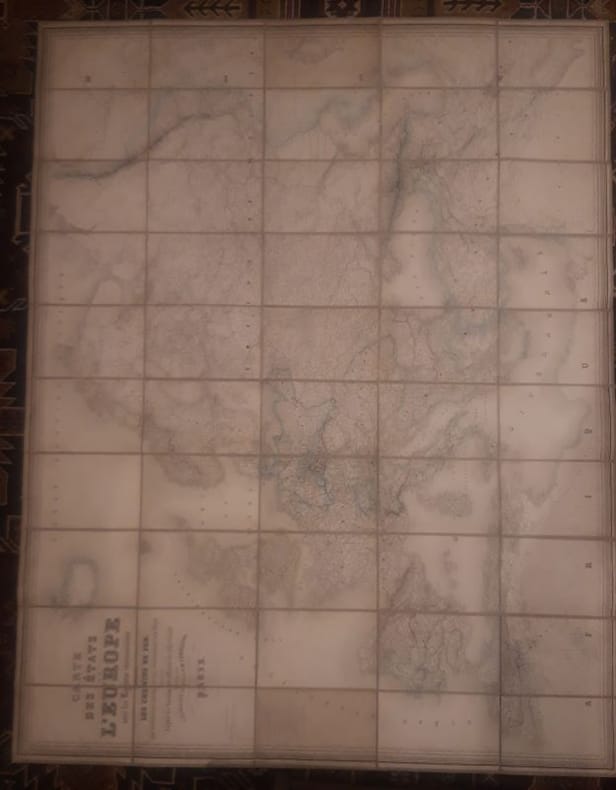
Sagansan.
Carte des Etats de l'Europe avec les régions circonvoisines, indiquant les chemins de fer, les principales routes et les subdivisions des états, dressée d'après les documents officiels les plus récents.
1868 1 160 cm x 120cms Carte Entoilée indiquant les chemins de fer, les principales routes et les subdivisions des états, dressée d'après les documents officiels les plus récents.Géographie gravée par Blondeau et écritures par Rousset.
Referenz des Buchhändlers : LCI-4059
|
|
|
Sagebrush Maps; Rand McNally
Eugene Springfield Oregon: Street Atlas
Sagebrush Maps 2001-01. Spiral-bound. Good. Sagebrush Maps unknown
Referenz des Buchhändlers : SONG0929591674 ISBN : 0929591674 9780929591674

|
|
|
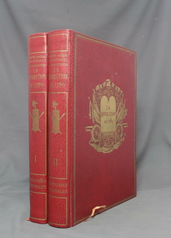
SAGNAC Philippe:
La Révolution de 1789.
A Paris, Les Ed. nationales, 1934. 2 volumes in-4 de XV-390-[6] + 412-[12] pages, reliure d’éditeur percailne rouge, dos lisses ornés, plats ornés d’un médaillon doré en leur centre et encadré de 3 filets dorés, couvertures conservées.
Referenz des Buchhändlers : 1643
|
|
|
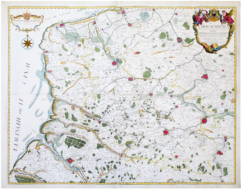
SAINT-ALEXIS (Constantin de).
[ARTOIS] Carte d’Artois dressée sur de nouveaux mémoires.
Arras, Barbier, 1741. En quatre feuilles jointes formant une carte de 97,3 x 119,6 cm.
Referenz des Buchhändlers : LBW-6681
|
|
|
SAINT-GERMAIN.-
Maître Pierre, ou le Savant de village. Géographie de la France.
Paris, Chez F.G. Levrault, 1834, in-12°, 216 p. + 3 cartes dépliantes, envois ms à la première page + stempel 'Hospice du Simplon', en page de titre. cartonnage originale illustrée. Bel exemplaire.
Referenz des Buchhändlers : 50921aaf
|
|
|
SAINT-JEAN-de-LUZ. MANUSCRIT.
Plan de St. Jean de Luz avec les projets d'aggrandissement du port.
[circa 1782]. 510 x 660 mm.
Referenz des Buchhändlers : LBW-4179

|
|
|
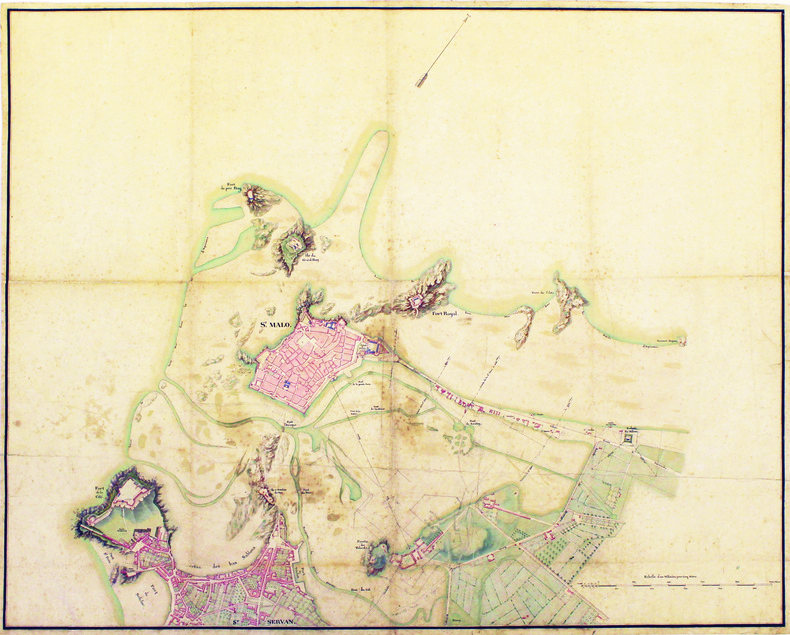
SAINT-MALO. MANUSCRIT.
[Plan de Saint-Malo et de Saint-Servan].
[circa 1830]. 870 x 720 mm, sur papier vélin.
Referenz des Buchhändlers : LBW-4189
|
|
|
SAINT-OMER. MANUSCRIT.
Plan de S.t Omer.
[circa 1710]. En 2 feuilles jointes de 510 x 715 mm.
Referenz des Buchhändlers : LBW-4193

|
|
|
SAINT-OMER. MANUSCRIT.
Plan de St Omer.
[circa 1750]. En 2 feuilles jointes de 435 x 600 mm, sur papier fin huilé.
Referenz des Buchhändlers : LBW-4194

|
|
|
SAINTE-CROIX par Ernest-Louis PAILLARD.
Les vallons de Sainte-Croix et des Granges de Sainte-Croix, dans le Haut Jura vaudois. Etude de géographie avec 22 cartes, dessins et graphiques dans le texte.
Ntel, société neuchâteloise de géographie 1943. Bel ex. broché, couv. D'orig. Gd in-8, 152 p. pour cette étude avec introductions, illustrations et sources.
Referenz des Buchhändlers : AUB-7920
|
|
|
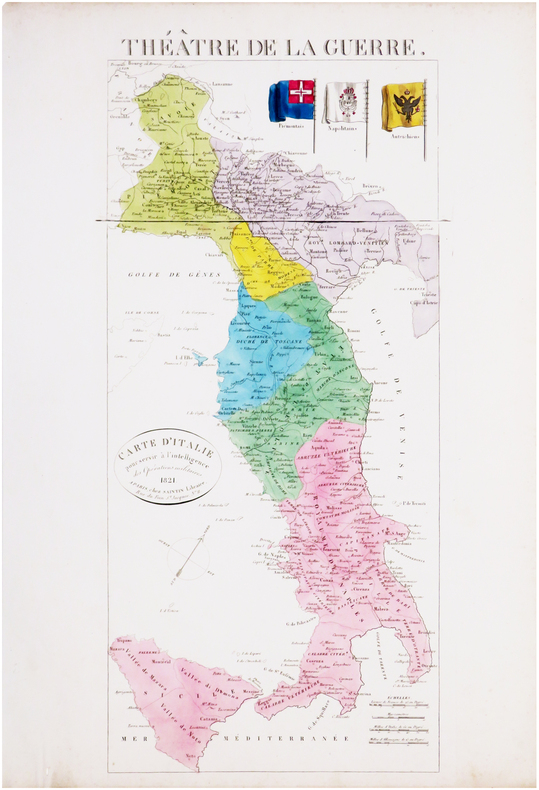
SAINTIN (Claude-Auguste).
Théâtre de la guerre. Carte d'Italie pour servir à l'intelligence des opérations militaires.
Paris, Saintin, 1821. 535 x 241 mm.
Referenz des Buchhändlers : LBW-8033
|
|
|
SAIT TALÂT (Büyük Erkâniharbiye IX. Sube Md. Deniz Kaymakami).
En eski Amerikan haritasi.
Very Good Turkish Modern cloth. Roy. 8vo. (24 x 17 cm). In Turkish. 16, [1] p., b/w ills. En eski Amerikan haritasi.
|
|
|
Sakellarakis, JA
Herakleion Museum
Previous owner's name on ffep. No other inscriptions or marks. No creasing to covers or to spine. A very clean crisp tight copy with bright unmarked boards and no bumping to corners. 144pp. Comes with a tucked-in map of Crete and details of public bus service.

|
|
|
Sakkas George K.
Crete in Colour : A Tourist Guide Book.
Athens: Artemis Pub 1972 Short interesting guide book to Crete. Pbk. 120p. plates some col. maps of Crete and street map of Iraklion. Very Good. Artemis Pub unknown
Referenz des Buchhändlers : 14736
|
|
|
Sakkas George K.
Crete in Colour : A Tourist Guide Book.
Athens: Artemis Pub 1972 Short interesting guide book to Crete. Pbk. 120p. plates some col. maps of Crete and street map of Iraklion Condition : Good. Very Good. Artemis Pub unknown
Referenz des Buchhändlers : 14737
|
|
|
Sakkas George K.
Crete in Colour : A Tourist Guide Book.
Athens: Artemis Pub 1972 Short interesting guide book to Crete. Pbk. 120p. plates some col. maps of Crete and street map of Iraklion. Very Good. Artemis Pub unknown
Referenz des Buchhändlers : 14735
|
|
|
Sakkas,George K.
Crete in Colour : A Tourist Guide Book.
Short interesting guide book to Crete. 120p. plates (some col.) maps of Crete and street map of Iraklion. Vintage copyY) Book
|
|
|
Sale, Richard ; Rudd, Peter
The Visitor's Guide to the Italian Lakes
No marks or inscriptions to contents. A very clean very tight copy with bright unmarked red cloth boards, discolouration to small part of upper rear corner and no bumping to corners. Dust jacket price clipped but not marked or torn or creased with general traces of storage. 256pp. Detailed guide to the Italian Lakes - Orta, Maggiore, Lugano, Como and Garda and the surrounding area. Well illustrated.

|
|
|
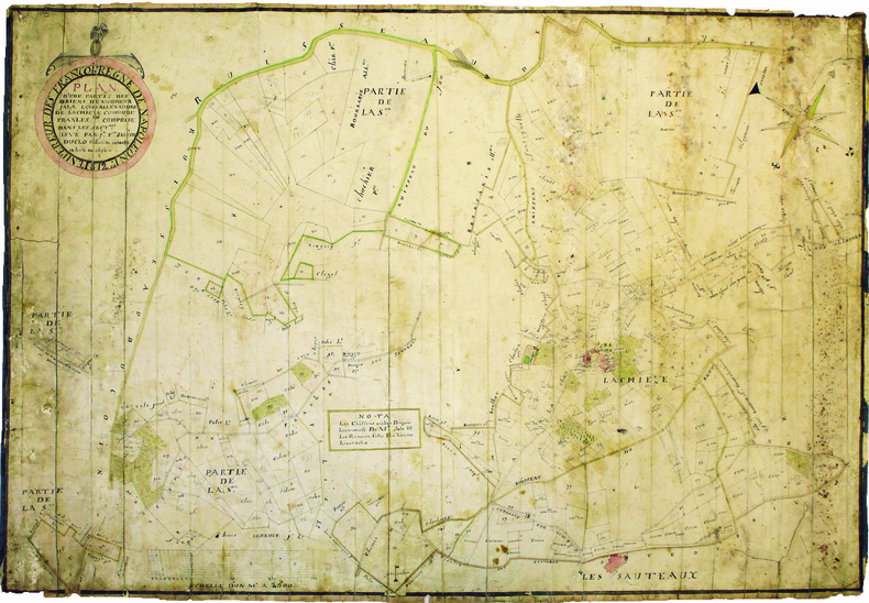
SALEON DUCLO (Jean-François). MANUSCRIT.
Plan d'une partie des biens de monsieur Jala Louis Allexandre de Lachieze, commune de Pranles comprise dans les sectons levé par Jn Fois Saléon Duclo géomètre du cadastre de la ville de Cheylard.
1812. 560 x 825 mm.
Referenz des Buchhändlers : LBW-4182
|
|
|
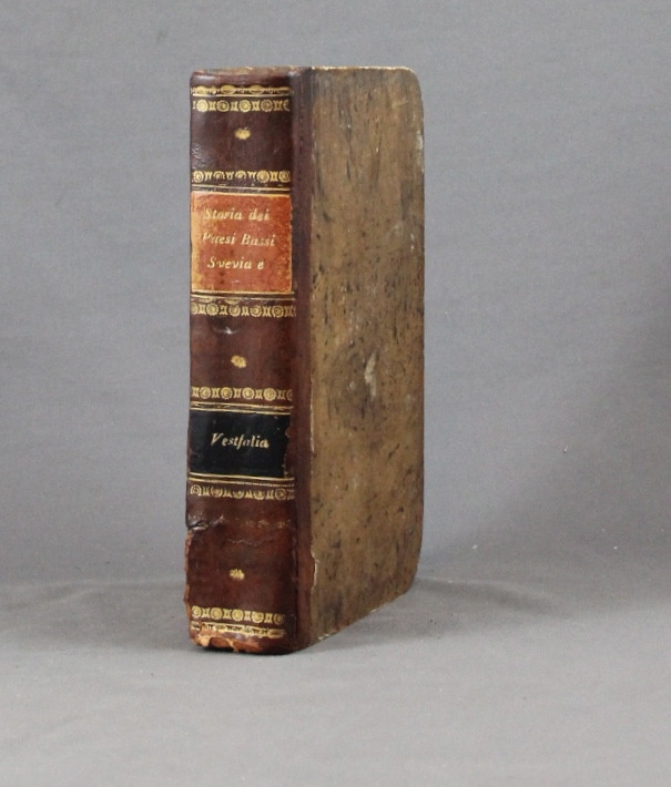
SALMON Thomas:
Lo stato presente du tutti i paesi, e popoli del mondo naturale, politico, e morale, con nuove osservazioni, e correzioni degli antichi, e moderni viaggiatori. Volume X. Dei circoli susseguenti dell'Imperio, cioe' Svevia, alto, e basso Reno, e Vestfalia e delle dieci provincie dei Paesi Bassi austriaci, e francesi.
Venezia, Giambatista Albrizzi, 1740. In-8 de [12]-502-[2]p. demi-basane brune, dos lisse, filets et fleurons dorés, pièces de titre et tomaison noir et orange (un mors fendu tristement recollé, coins tapés, rousseurs, annotations).
Referenz des Buchhändlers : 6334
|
|
|
Salvador, I.
Geschichte der RÖmerherrschaft in JudÄa und der ZerstÖrung Jerusalems [Vol. 2 ONLY]
[Vol.2 ONLY]. 8' 483pp. glit hardcover. cover slightly worn. ex library with usual words. a few pencil marks on inner cover. some aging marks on pages. a couple of maps added. else in fair condition.
|
|
|
Samson, Pet. Heinr. [Peter Heinrich]
Die Entwickelung der Freien und Hansestadt Hamburg von der Entstehung bis auf die Gegenwart in geschichtl. Grundzügen, Sagen u. Biographien, nach den Quellen chronologisch geordnet.
Hamburg, Carl Pottier, 1886. VIII, 119 S. Mit 1 gefalt. farb. lithograph. Straßenplan. HLn. d. Zt.
Referenz des Buchhändlers : 17370

|
|
|
Samuel Bagster
ILLUSTRATIONS TO THE HOLY SCRIPTURES Consisting of Eighteen Maps and Plans
London: Samuel Bagster and Sons 1856. Undated but Plan of Jerusalem dated 1837 and inscription to the front free end paper dated 1859 Copac suggests 1856. The maps state "Engraved for Bagster's English Version of the Polyglott Bible" and have evidently been borrowed from that work to make up this small book of maps. Title page explanatory list; follwed by 12 leaves of engraved maps printed to one side only consisting of double and single page maps most of which hand-coloured. All present in accordance with the explanatory list but not bound in the same order. Original red-coated end papers all edges dyed red. Original quarter tan morocco over pink cloth boards with gilt lettering to the upper board. Very good a few ink marks - more so to the rear board. Contents good and tight all maps in very good clean condition the small private stamp of H. E. Spencer near contemporary has been liberally applied to the front blank and title pages. A very good copy - scarce Copac lists only three copies. Hard Cover. Very Good. 12mo. Samuel Bagster and Sons Hardcover
Referenz des Buchhändlers : 023880

|
|
|
Samuel Eliot & Commager Henry Steele Morrison Morison; Illustrator Maps Photos
The Growth Of The American Republic: Volume Two.
Oxford University Press 1942. Hardcover. Acceptable. Disclaimer:A readable copy. All pages are intact and the cover is intact. Pages can include considerable notes-in pen or highlighter-but the notes cannot obscure the text. At ThriftBooks our motto is: Read More Spend Less.Dust jacket quality is not guaranteed. Oxford University Press hardcover
Referenz des Buchhändlers : GB00226EPM4I5N00

|
|
|
Samuel Merwin endpapers of maps with former owner stamp & some fox Beautiful coloured frontispiece with small stain at top pag
Silk A Legend as narrated in the journals & correspondence of Jan Po
Houghton Mifflin Printed in Great Britain. HBNoDJ 1923 1st editionGreen Silk Covers lettered in Gold GiltCover some stains & small amount clear tape & some wear Hinge starting slightly interior Nice & TightVG-/G- AS-IS NODJ. Houghton Mifflin, Printed in Great Britain unknown
Referenz des Buchhändlers : 7552
|
|
|
Sanborn Anne Fay; Maps Illustrator
Transylvania and the Hungarian-Rumanian Problem: A Symposium Compiled by the Danubian/Research and Information Center. Ed by Anne Fay Sanborn
Danubian Pr 1979-09-01. Hardcover. Very Good. Hardcover no marks noted in text no dj cover stainedAND AS ALWAYS SHIPPED IN 24 HOURS; and emailed to you a USPS tracking number on all orders; all books are sanitized and cleaned for your protection before mailing Danubian Pr hardcover
Referenz des Buchhändlers : 121120020 ISBN : 0879340215 9780879340216
|
|
|
Sanborn Anne Fay; Maps Illustrator
Transylvania and the Hungarian-Rumanian Problem: A Symposium Compiled by the Danubian/Research and Information Center. Ed by Anne Fay Sanborn
Danubian Pr 1979-09-01. Hardcover. Very Good. Hardcover with dj no marks noted in textAND AS ALWAYS SHIPPED IN 24 HOURS; and emailed to you a USPS tracking number on all orders; all books are sanitized and cleaned for your protection before mailing Danubian Pr hardcover
Referenz des Buchhändlers : 121120024 ISBN : 0879340215 9780879340216
|
|
|
SANDBY (Thomas) & SANDBY (Paul).
[GRAND PARC de WINDSOR] View from the north side of the Virginia river, near the Manour Lodge.
London, John Boydell, March the 2.d 1772. 335 x 563 mm.
Referenz des Buchhändlers : LBW-6246

|
|
|
SANDEMANN;
ORLEANS (Loiret).
Paris Benard circa 1850 216 x 295 mm.
Referenz des Buchhändlers : LBW03d6b

|
|
|
Sanderson Ivan T. chapter head drawings by F. Enderoth Saunders maps and charts by the author Dust Wrapper design by Samuel H.
FOLLOW THE WHALE
Boston: Little Brown and Company 1956. Fair in Fair dust jacket. 1956. First Edition. Hardcover. First edition stated. "From time immemorial man has pursued the whale. This is the story of the peoples who have engaged in that pursuit---its historical cultural and economic consequences". 423 pages illustrated with maps including the endpapers charts and drawings general whaling chronology note on maps appendixes bibliography by periods and subjects index. Otherwise VG copy light wear very light bumping to some corners with owner's name and date to the front free endpaper and pencil annotations to the margins of a dozen or two pages scattered throughout the book in worn/torn/chipped especially to the spine head/etc Good at best Dust Wrapper. . Little Brown and Company [1956] hardcover
Referenz des Buchhändlers : 53121

|
|
|
SANDMANN.
MELUN (Seine et Marne).
Paris, Benard, [circa 1850]. 212 x 298 mm.
Referenz des Buchhändlers : LBW03d75
|
|
|
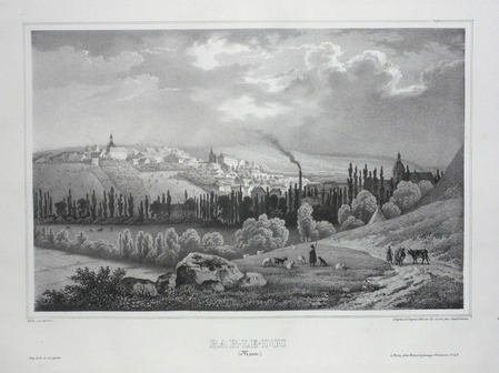
SANDMANN;
BAR-LE-DUC (Meuse).
Paris Benard circa 1850 222 x 295 mm.
Referenz des Buchhändlers : LBW03d58
|
|
 Per e-mail erhalten
 Als pdf-Dokument herunterladen
 RSS feed


