|
White TH.Terence Hanbury and Maps on End Papers T. H.
The Master an Adventure Story
Hardcover. Very Good. VG book & jacket. 1957.3.50 jacket price hardcover
Referenz des Buchhändlers : OU-36UB-0E9R
|
|
|
White Denim; Maps & Atlases
Daytrotter Vinyl Series No 5
Daytrotter 2012-12-11. Vinyl. Used:Good. Daytrotter unknown
Referenz des Buchhändlers : DADAXB00AEBB8AQ
|
|
|
White, Nelia; Chamberlain, W.; Laveridge, G.; Manchester, W.; MacKaye, Milton; Frank, Stanley; Linn, Edward; Barber, Noel; Mowat, Farley; Pagenstecher, Adelyn; Taylor, Frank; Baum, A.; Richter, Conrad; Le May, Alan
The Saturday Evening Post, April 13, 1957 - The Woes of Willie Mays / Governor Meyner of New Jersey
140 pages. Fiction: End of a Marriage; The Platoon of Pariahs; A Dream for Sale; Record Run; The Lady (part 3 of 4); Kiowa Moon (part 5 of 7). Articles: The Glamorous Governor of New Jersey - Bob Meyner abandoned bachelorhood mid-term; The Seven Dictators of Broadway - Reviewers John McClain, John Chapman, Richard Watts, Jr.; Robert Coleman, Tom Donnelly, Walter Kerr and Brooks Atkinson; ; The Woes of Willy Mays - why 1956 was almost a nightmare for him; The Oddest War Ever Fought - The Aden-Yemen war has been going on for 2,000 years, with daily time-outs for prayers and narcotic binges - article with maps and interesting photos; The Face of America - Prize Babies (photo); Pals of My Childhood - Farley Mowat writes of his two hilarious pets; My Daughter's Silent World - Adelyn Pagenstecher was told her daugher Mari was deaf; A Bloom for Mother-In-Law - beautiful color photos of tulips and daffodils ; Wonderful Wooden Sandwich - how plywood turns waste wood into a useful product - with photo of Sol Walter (Tony) of United States Plywood.. Ads: Liberty Mutual auto accident insurance; Savage brand lawn mowers; Bunnygrans - one-page photo ad featuring Lucille Ball and son; Nice Easter-themed two-page photo ad for Buick cars; National Cash Register (NCR) adding machines; Fantastic three-page color ad for International trucks; Vigoro plant foods; One-page black and white photo ad for movie "The Spirit of St. Louis" starring James Stewart; Great two-page color-photo ad for the 1957 Dodge Swept-wing convertible featuring Lawrence Welk; Pink Westinghouse clothes washer; 1957 Frigidaire pink (interior) fridge; 1957 Ford - two-page color-photo ad; Pall Mall cigarettes - cowboy scene; Page & Shaw chocolates; Chevrolet - two-page color photo of four 1957 models; Elgin Watches (graduation theme); American Airlines - nice color two-page ad shows glamorous lady boarding plane; L&M cigarettes - nautical theme; Eaton tandem axle ad features Joseph J. Hock of Baltimore; Longines-Wittnauer Watches; Nice two-page color ad for Kodak's broad line of cameras; Hit Parade cigarettes; Kings Men aftershave "I don't want to be a tycoon"; Douglas DC-7 airliner; Viewmaster; Johnson outboard motors; Harrison car air conditioning; Pullman cars; Evinrude outboards; Springfield mowers and tillers; Richard Harding Davis is honored in a U.S. Savings Bond ad; Vista auto wax; Nice color one-page Viceroy cigarette ad features tennis player Pancho Gonzales and his lovely wife Henrietta; Back cover Coke ad with sailing illustration. Average wear. Unmarked. A sound vintage copy. Magazine

|
|
|
White, Walter
A Month in Yorkshire (Signed By Publisher)
Appears unread. Signed to front end paper 'With the publisher's compliments M.T.D. Rigg, Dec 01'. No other marks or inscriptions. A lovely clean very tight copy with bright unmarked boards and no bumping to corners. Dust jacket not price clipped or marked or torn or creased. 386pp. The original travel/history account was published in 1858. This is the second edition facsimile.

|
|
|
Whitehead, Jack
Growth of Camden Town, The: AD 1800-2000
Book is in excellent condition with very light shelf wear to covers only. Binding is solid and square, covers have sharp corners, exterior shows no other blemishes, text/interior is clean and free of marking of any kind. 231 pages, heavily illustrated with color and b&w photos, drawings, maps, cross sections, architectural drawings. Contents include: Regents canal, Park Village east, Cumberland Basin, London, Girmingham, Railway, Robert B. Dockray, the Roundhouse, North London Railway, Great Wall of Camden, Ice wells, Gilbey's Wine and Spirits, Booth Poverty, survey, maps, Purfleet wharf, Harlow, Pirates club, Jubilee Waterside Centre, Stables Market, Suffolk wharf, Albert street, etc.

|
|
|
Whitehouse David and Ruth; maps drawn by John Woodcock and Shalom Schotten
ARCHAEOLOGICAL ATLAS OF THE WORLD
San Francisco CA: W. H. Freeman and Company. G/No Dustjacket. 1975. . Paperback. Sm 4to. 272 pp. rubbed bumped . W. H. Freeman and Company paperback
Referenz des Buchhändlers : BOOKS268939 ISBN : 0716702738 9780716702733
|
|
|
Whitney Josiah Dwight photographs by Carleton E. Watkins; maps by Charles Frederick Hoffmann; introduction by Jim Snyder
The Yosemite Book facsimile of 1868 edition on CD-ROM
<p>New York: Julius Bien Oakland: Octavo 1868; 2003. 1st edition. Other Binding. New/No Jacket as issued. New digital facsimile in electronic PDF format on CD-ROM disc of the 1868 first edition of this landmark of nature photography and conservation. California State Geologist Josiah Dwight Whitney created this lavish publication issued in an edition of only 250 copies as part of his campaign to claim and reserve the area that later became Yosemite National Park. Photographer Carleton Watkins who had earlier made his fame with breathtaking views of the Yosemite Valley contributed albumen-print photographs actual prints of which were mounted into each copy. The book also features two large- scale foldout maps by Charles Hoffmann and others. This Octavo Edition contains detailed digital images of every page of the original book as well as optimized viewing images of the plates and maps and supplementary materials including an introductory essay extra maps some never before published a provenance essay and detailed bibliographical information. "The most famous and rare book published about Yosemite. The volume was as much a work of photographic art as it was a guidebook."--Yosemite Association Newsletter</p> New York: Julius Bien (Oakland: Octavo)
Referenz des Buchhändlers : 8VWHYB01 ISBN : 1591100127 9781591100126

|
|
|
Wichmann, E. H. (Ernst Heinrich)
Begleitworte zu der Wandkarte des Hamburger Gebiets nebst Umgebung. Eine historisch topographische Beschreibung der Umgebung von Hamburg als Leitfaden für den Unterricht in der Heimatskunde.
Hamburg, Hermann Grüning, 1867. 144 S. Kl.-8vo. 16,5 cm. OBrosch.
Referenz des Buchhändlers : 91409

|
|
|
Wichmann, E. H. (Ernst Heinrich)
Begleitworte zu der Wandkarte des Hamburger Gebiets nebst Umgebung. Eine historisch topographische Beschreibung der Umgebung von Hamburg als Leitfaden für den Unterricht in der Heimatskunde.
Hamburg, Hermann Grüning, 1867. 144 S. Kl.-8vo. 17 cm. Spät. HLn. mit neuen Vorsatzbll.
Referenz des Buchhändlers : 56770

|
|
|
Wichmann, E. H. [Ernst Heinrich] (Hrsg.)
Heimatskunde. Topographische, historische und statistische Beschreibung von Hamburg und der Vorstadt St. Georg.
Hamburg, Wilhelm Jowien, 1863. VIII S., 1 Bl., 242 S. Mit 1 farb. lithograph. Faltkte. (Bildmaß 38,56 x 53,5 cm, darauf 4 historische Pläne). Blindgeprägt. OLn. (Rücken und Vorsätze fachmännisch ersetzt).
Referenz des Buchhändlers : 17571

|
|
|
Wide World of Maps
Greater Las Vegas Street Guide & Directory 2012 / 2013 NV Atlas
Wide World of Maps 2012-01-01. Spiral-bound. VeryGood. 9.5000 inches 8.5000 inches. Wide World of Maps unknown
Referenz des Buchhändlers : mon0002257278 ISBN : 1934839191 9781934839195
|
|
|
Wide World of Maps Inc.
Maricopa Florence & Coolidge Street Map
2010-01-01. Good. Ships with Tracking Number! INTERNATIONAL WORLDWIDE Shipping available. May not contain Access Codes or Supplements. May be re-issue. May be ex-library. Shipping & Handling by region. Buy with confidence excellent customer service! unknown
Referenz des Buchhändlers : 1934839132 ISBN : 1934839132 9781934839133

|
|
|
Wide World of Maps Inc.
Phoenix Metropolitan Street Atlas
Wide World of Maps Inc. 2013. Spiral-bound. Acceptable. Disclaimer:A readable copy. All pages are intact and the cover is intact. Pages can include considerable notes-in pen or highlighter-but the notes cannot obscure the text. At ThriftBooks our motto is: Read More Spend Less.Dust jacket quality is not guaranteed. Wide World of Maps, Inc. unknown
Referenz des Buchhändlers : G1934839221I5N00 ISBN : 1934839221 9781934839225

|
|
|
Wide World of Maps
Tucson Metropolitan Street Atlas : 2002 Edition
Wide World of Maps Incorporated 2002. Spiral-bound. Good. Disclaimer:A copy that has been read but remains in clean condition. All pages are intact and the cover is intact. The spine may show signs of wear. Pages can include limited notes and highlighting and the copy can include previous owner inscriptions. At ThriftBooks our motto is: Read More Spend Less.Dust jacket quality is not guaranteed. Wide World of Maps, Incorporated unknown
Referenz des Buchhändlers : G1887749330I3N00 ISBN : 1887749330 9781887749336

|
|
|
Wide World of Maps
Yavapai/Coconino Counties Street & Road Atlas
Phoenix Mapping Service. Used - Very Good. Ships from Reno NV. Great condition for a used book! Minimal wear. 100% Money Back Guarantee. Shipped to over one million happy customers. Your purchase benefits world literacy! Phoenix Mapping Service unknown
Referenz des Buchhändlers : GRP114747893 ISBN : 1887749373 9781887749374
|
|
|
Widhalm, Richard; Mück, Thomas
Topic Maps - Semantische Suche im Internet
Mak. Bibl.
|
|
|
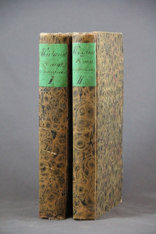
WIELAND Johannes:
Geschichte der Kriegsbegebenheiten in Helvetien und Rhätien als Handbuch zum Militairunterricht für Schweizeroffiziere aller Waffen.
Basel, In der Schweighauser’schen Buchhandlung, 1827. 2 volumes in-8 de 552 + 444 pages, cartonnages du temps recouverts de papier marbré, dos lisses, petite découpure en haut des 2 pages de garde (probablement afin d’ôter un nom ou un tampon).
Referenz des Buchhändlers : 1454
|
|
|
Wieland, Johann Wolfgang
Karte des historischen Herzogtums Oppeln, 1736. Principatus Silesiae Oppoliensis exactissima Tabula geographica: sistens Circulos Oppoliensem Ober-Glogau Gross Strelitz, Cosel, Tost. Rosenberg, Falckenberg & Lubleniz. Cum Spec. S. Caes. Rque. Mtis Privilegio. [Altkolorierter Original-Kupferstich / original coloured copper engraving].
o.J. [2 Warenabbildungen]
Referenz des Buchhändlers : 65322CB

|
|
|
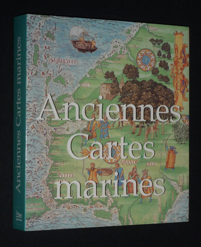
Wigal Donald
Anciennes cartes maritimes
Sirrocco Broché 2006 In-12 (14,8 x 16,2 cm), broché, 255 pages, illustrations en couleurs ; très bon état. Livraison a domicile (La Poste) ou en Mondial Relay sur simple demande.
Referenz des Buchhändlers : fj1065
|
|
|
WILLOUGBY Martin
"La carte postale; une histoire illustrée du tournant du siècle à nos jours."
Paris, Bookking International, 1993. 23 x 30, 153 pp., très nombreuses illustrations en couleurs, reliure d'édition carton imprimé + jaquette, très bon état.
Referenz des Buchhändlers : 73751 ISBN : 287714173
|
|
|
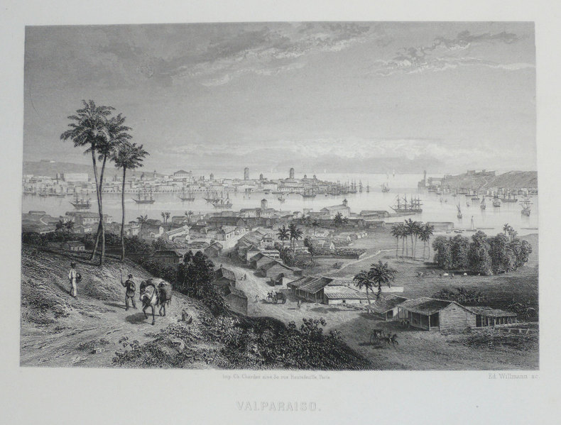
WILLMANN (Edward);
[CHILI] Valparaiso.
Paris circa 1860 126 x 168 mm.
Referenz des Buchhändlers : LBW-1203
|
|
|
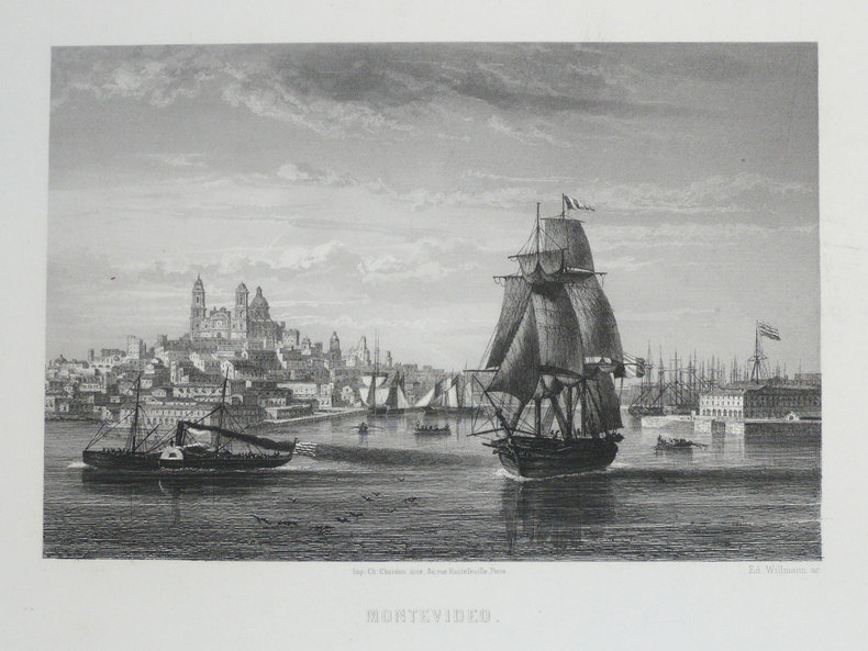
WILLMANN (Edward).
[URUGUAY] Montevideo.
Paris, [circa 1860]. 126 x 168 mm.
Referenz des Buchhändlers : LBW-1233
|
|
|
WILLIAMS & Co
Articles et Costumes pour Sports et Jeux.
Paris, Williams, Rue Caumartin, 1924. In 8 (115 x 195) de 72 p. Agrafé, couverture illustrée en brun. Excellent état.
Referenz des Buchhändlers : EYL-175
|
|
|
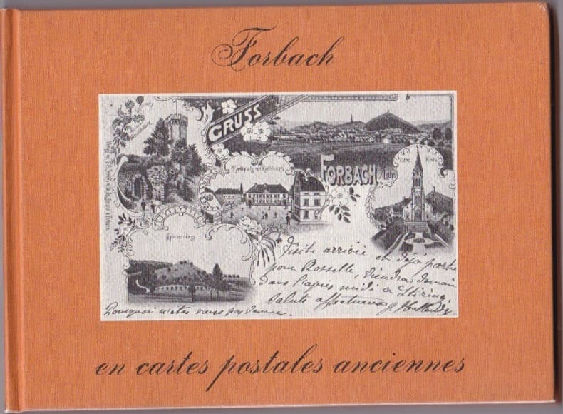
WILMIN H
Forbach En Cartes Postales Anciennes
Pays Bas Bibliotheque Europeenne 1980 In 12 Oblong Non paginé - env. 80 pages - cartonnage editeur illustré - trés nombreuses reproductions de CPA - bel etat
Referenz des Buchhändlers : RES10L74
|
|
|
WILMIN H
Forbach En Cartes Postales Anciennes
Pays Bas Bibliotheque Europeenne 1980 In 12 Oblong Non paginé - env. 80 pages - cartonnage editeur illustré - trés nombreuses reproductions de CPA - bel etat
Referenz des Buchhändlers : RES10L74
|
|
|
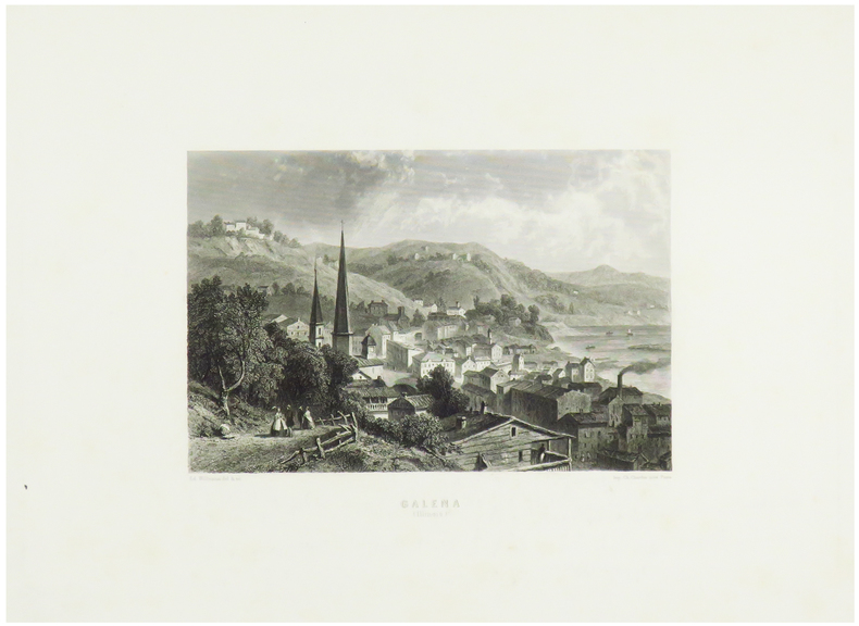
WILLMANN (Edward).
Galena (Illinois).
Paris, [circa 1860]. 131 x 172 mm.
Referenz des Buchhändlers : LBW-1248
|
|
|
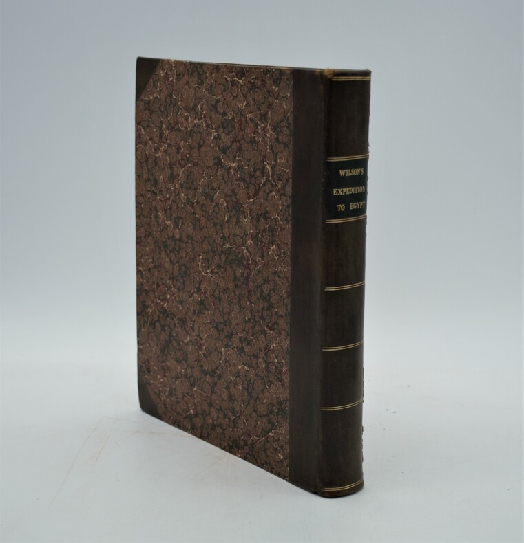
WILSON, Robert Thomas
History Of The British Expedition To Egypt; To Which Is Subjoined A Sketch Of The Present State Of That Country And Its Means Of Defence; Illustrated With Maps And Portraits of Sir Ralph Abercromby
London: T. Egerton, 1803. in-4° , (270x215) , relié demi basane et coins , dos lisse avec pièce de titre et auteur, xxi-387pp , frontispice , 2 tableaux dépliants et 3 cartes dépliantes légèrement coloriées ,quelques rousseurs , déchirure à une carte sans manque ,ex-libris charles Kettaneh, bon exemplaire .
Referenz des Buchhändlers : PHO-893
|
|
|
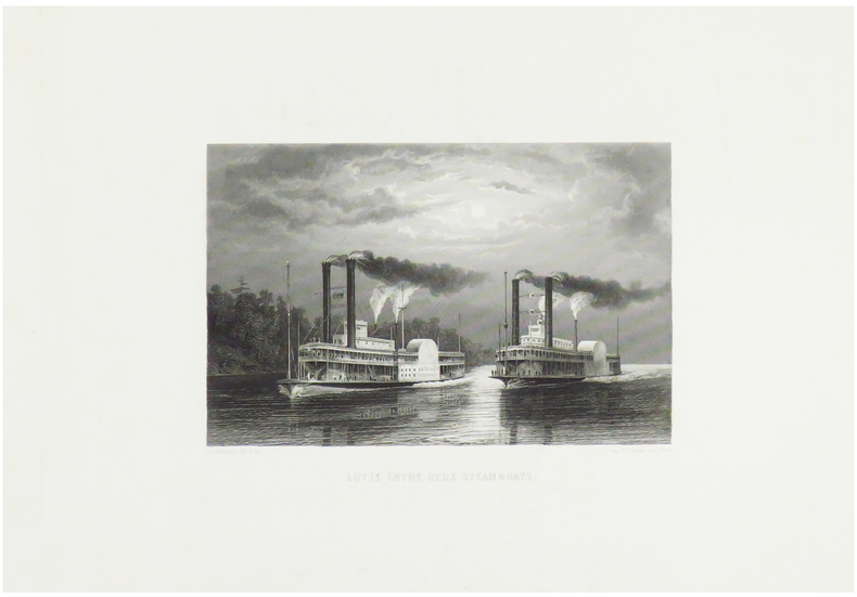
WILLMANN (Edward).
Lutte entre deux steamboats.
Paris, [circa 1860]. 125 x 170 mm.
Referenz des Buchhändlers : LBW-1249
|
|
|
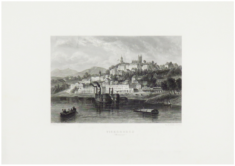
WILLMANN (Edward).
Vicksburgh (Missouri).
Paris, [circa 1860]. 130 x 170 mm.
Referenz des Buchhändlers : LBW-1247
|
|
|
wilbur cross Illustrated by paintings prints drawings maps
Naval Battles and Heroes
american heritage 1960. Used - Good. Ships from Reno NV. Shows some signs of wear and may have some markings on the inside. 100% Money Back Guarantee. Shipped to over one million happy customers. Your purchase benefits world literacy! american heritage, 1960 unknown
Referenz des Buchhändlers : GRP116949921
|
|
|
Wilbur E. Editor Garrett Maps photos Illustrator
National Geographic Index 1888-1988
National Geo. Society 1989. National Geo. Society 1989 Fine/Very Good DJ Unread. Bright red cloth with gold lettering and design. Bright mended jacket protected in clear archival Brodart dust jacket cover. Large Heavy Item. Hardcover. Fine/Very Good DJ. No Exp. National Geo. Society Hardcover
Referenz des Buchhändlers : 2000034744
|
|
|
Wiliam L Langer; Illustrator Maps
European Alliances and Alignments 1871-1890
Vintage 1964. Paperback. Good. good plus paperback light creasing/fading to cover former owner's stamp to bottom edge very slight water stain to bottom edge Vintage paperback
Referenz des Buchhändlers : 128484
|
|
|
Wilkes John Pugsley William H. William Howard donor WH. Pugsley Collection of Early Canadian Maps W. H.
British Colonies in North America 1797 Leather Bound
2019. Leather Bound. New. Leather Binding on Spine and Corners with Golden Leaf Printing on round Spine extra customization on request like complete leather Golden Screen printing in Front Color Leather Colored book etc. Reprinted in 2019 with the help of original edition published long back 1797. This book is printed in black & white sewing binding for longer life Printed on high quality Paper re-sized as per Current standards professionally processed without changing its contents. As these are old books we processed each page manually and make them readable but in some cases some pages which are blur or missing or black spots. If it is multi volume set then it is only single volume if you wish to order a specific or all the volumes you may contact us. We expect that you will understand our compulsion in these books. We found this book important for the readers who want to know more about our old treasure so we brought it back to the shelves. Hope you will like it and give your comments and suggestions. Lang: - English. EXTRA 10 DAYS APART FROM THE NORMAL SHIPPING PERIOD WILL BE REQUIRED FOR LEATHER BOUND BOOKS. COMPLETE LEATHER WILL COST YOU EXTRA US$ 25 APART FROM THE LEATHER BOUND BOOKS. hardcover
Referenz des Buchhändlers : LB1111007011100
|
|
|
Wilkes John Pugsley William H. William Howard donor WH. Pugsley Collection of Early Canadian Maps W. H.
British Colonies in North America 1797 FULL LEATHER BOUND
2019. SUPER DELUXE EDITION. New. Antique look with Golden Leaf Printing and embossing with round Spine completely handmade bindingextra customization on request like Color Leather Colored book special gold leaf printing etc. Reprinted in 2019 with the help of original edition published long back 1797. This book is printed in black & white sewing binding for longer life Printed on high quality Paper re-sized as per Current standards professionally processed without changing its contents. As these are old books we processed each page manually and make them readable but in some cases some pages which are blur or missing or black spots. If it is multi volume set then it is only single volume if you wish to order a specific or all the volumes you may contact us. We expect that you will understand our compulsion in these books. We found this book important for the readers who want to know more about our old treasure in old look so we brought it back to the shelves. Hope you will like it and give your comments and suggestions. Lang: - English. EXTRA 10 DAYS APART FROM THE NORMAL SHIPPING PERIOD WILL BE REQUIRED. Normal Hardbound Edition is also available on request. unknown
Referenz des Buchhändlers : SD1111007011100
|
|
|
Wilkes John Pugsley William H. William Howard donor WH. Pugsley Collection of Early Canadian Maps W. H.
British Colonies in North America 1797
2019. Paperback. New. Lang: - English. Reprinted in 2019 with the help of original edition published long back 1797. This book is Printed in black & white sewing binding for longer life with Matt laminated multi-Colour Soft Cover HARDCOVER EDITION IS ALSO AVAILABLE Printed on high quality Paper re-sized as per Current standards professionally processed without changing its contents. As these are old books we processed each page manually and make them readable but in some cases some pages which are blur or missing or black spots. If it is multi volume set then it is only single volume if you wish to order a specific or all the volumes you may contact us. We expect that you will understand our compulsion in these books. We found this book important for the readers who want to know more about our old treasure so we brought it back to the shelves. Any type of Customisation is possible with extra charges. Hope you will like it and give your comments and suggestions. paperback
Referenz des Buchhändlers : PB1111007011100
|
|
|
Wilkes John Pugsley William H. William Howard donor WH. Pugsley Collection of Early Canadian Maps W. H.
British Colonies in North America 1797 Hardcover
2019. Hardcover. New. Lang: - English. Reprinted in 2019 with the help of original edition published long back 1797. This book is Printed in black & white Hardcover sewing binding for longer life with Matt laminated multi-Colour Dust Cover Printed on high quality Paper re-sized as per Current standards professionally processed without changing its contents. As these are old books we processed each page manually and make them readable but in some cases some pages which are blur or missing or black spots. If it is multi volume set then it is only single volume if you wish to order a specific or all the volumes you may contact us. We expect that you will understand our compulsion in these books. We found this book important for the readers who want to know more about our old treasure so we brought it back to the shelves. Any type of Customisation is possible with extra charges. Hope you will like it and give your comments and suggestions. hardcover
Referenz des Buchhändlers : 1111007011100
|
|
|
Will Durant; Illustrator Glossy B&W illust. EP Maps
Life of Greece "the Story of Civilization" Series Part 2 II Two
simon & schuster Pub 1966-01-01. Unknown Binding. Very Good. Nice looking book has minor edge wear.dusk jacket is faded & has tears.Pages are tan and not crisp white. simon & schuster Pub unknown
Referenz des Buchhändlers : 641110222004
|
|
|
Willett, B. M. . [et al.] (eds.)
Philip's Modern School Atlas
85th edition. Fine hbk bound in glazed pictorial boards. Co-editors, D. Gaylard, L. Prince-Smith, J. Russell, R. Smith, A. Wells. ISBN 0540055549. 21219. eng
|
|
|
William C. Herow Maps Illustrator
National Park Service Camping Guide : Second Edition
Roundabout Publications 2004-01-01. Paperback. Used:Good. Roundabout Publications paperback
Referenz des Buchhändlers : DADAX1885464061 ISBN : 1885464061 9781885464064
|
|
|
William C. Herow; Illustrator Maps
National Park Service Camping Guide : Second Edition
Roundabout Publications 2004. Paperback. Good. Roundabout Publications paperback
Referenz des Buchhändlers : SONG1885464061 ISBN : 1885464061 9781885464064
|
|
|
William Camden; Epistle Dedicatory by Edmund Gibson; Maps by Robert Morden
Camden's Britannia Newly Translated into English: with large additions and improvements
Edmund Gibson of Queens-College in Oxford printed by F Collins for A Swalle at the Unicorn at the West-End of St. Pauls Church-Yard; and A & J Churchil at the Black Swan in Pater-Noster-Row Oxford and London 1695. First Edition. Hardcover. Very Good Condition/No Dust Jacket. Illustrator: Robert Morden. Recent library rebind with replacement end-papers library labels on new end-papers only no labels on original pages and no library stamps anywhere. Complete work containing all texts maps and plates listed below as published and original to this publication except that the Map showing 17th century England is missing and a page of the index COR-GRA is missing. Fresh covers and spine sound binding. Faded red text block edges. Clean pages plates and maps very occasional minor flaws are described below. Two binding stubs between columns xvi and xvii. Occasional short creases across corners and very occasional loss of extreme corner on lower edge. List of Contents: New end paper; Frontis neat repair on reverse; Title Page; Epistle Dedicatory 2; The Preface To The Reader and Advertisement 4; The Life Of Mr Camden 11; Mr Camden's Preface 5; A Catalogue of Some Books and Treatises belonging to the Antiquities of England and Scotland and Ireland 5; Antoninus's Itinerary Through Britain 2; The General Heads of the Introduction and Counties of England 1; Britain The Manners of the Britains The Romans in Britain British Coins Roman Coins The Destruction of Britain Britains of Armorica Wales and Cornwall The Picts Scots The English Saxons Saxon Coins Danes The Normans The Division of Britain The Degrees of England The Law Courts of England The Earl Marshall of England CXCV columns; The Counties of England and Wales 1-876 columns except 833-848; Scotland Ireland and the British Islands 877-1116 columns; The Annals of Ireland 18; Index 20 last page has corner missing with loss of text to advertisement; Appendix 2. List of Plates and Maps: Frontis neat repair on reverse; Britannia Saxonica minor worm damage in lower margin; Britannia Romana minor worm damage in lower margin; British Coins x8 one with corner of margin missing; Cornwall by Robert Morden; Devonshire; Dorset Shire; Somerset Shire; Wilt Shire; Stonehenge vignette; Hamp Shire; Bark Shire; Surrey; Sussex; Kent double fold; Glocester Shire; Oxford Shire; Buckingham Shire; Bedford Shire; Hertford Shire; Midlesex; Essex; Suffolk; Norfolk double fold partial split on fold; Cambridge Shire; Huntington Shire; Northampton Shire; Leicester Shire; Comitatus Rotelandiae Tabula Nova & Aucta Rutland; Lincoln Shire; Nottingham Shire; Darby Shire; Warwick Shire; Worcester Shire; Stafford Shire; Shrop Shire; The County Palatine of Chester Cheshire; Hereford Shire several small brown marks; South Wales; The County of Monmouth; North Wales small pale brown mark; Curiosities of Wales; The West Riding of York Shire; The East Riding of Yorkshire; The North Riding of Yorkshire; Episcopaius Dunelmensis Vulgo The Bishoprick of Durham; The County Palatine of Lancaster Lancashire; Westmorland; Cumberland; Northumberland; Scotland; The Kingdom of Ireland; The Smallest Islands in the British Ocean - Farne Holy Man Scilly Jersey Garnsey Guernsey Alderney White; First edition in this translation. No dust jacket as published. Illustrator: Robert Morden. Quantity Available: 1. Shipped Weight: 3-4kg. Pictures of this item not already displayed here available upon request. Inventory No: 42019081083. These books are much heavier than 1kg and may incur significant additional delivery charges for some delivery services to some locations. Edmund Gibson of Queens-College in Oxford, printed by F Collins, for A Swalle at the Unicorn at the West-End of St. Pauls Church hardcover
Referenz des Buchhändlers : 42019081083

|
|
|
William Guthrie
Geographical Historical and Commercial Grammar Kingdoms & Maps of the World 1792
1792. leather. Fair. Photo Gallery Original Edition <b>-RARE!-</b> <b>1792 -Thirteenth Edition- </b>Corrected First Edition was about 1770 Publisher-Printing Location: Printed for Charles Dilly etc. London Author: William Guthrie the Astronomical Part by James Ferguson Date: 1792 Size and Page Count: 5.5 X 8.5 Tall; 910 Pages Condition: -Fair- Leather Bound that has <b>ancient repairs</b> with leather on hinge and spine corners heavy wear a few pages have stain spots tears on edges Foxing heavier on front pages; text block Good many fold out maps that extend at their fold past the paper text block that have wear and tears from storage.over 220 years <br /><br />Illustrations Information: <b>15 foldout MAPS and Hundreds of Tables and Charts</b> -------- An excellent opportunity for the collector researcher or historian --------- Articles and <i>Information: Includes: </i><br />Title page <br />advertisement bibliography of changes to each edition up to this one <b>mentions the 13 Colonies</b> <br />Preface6 pages <br />Contents <br />Introduction pages 1 to 58 <br />Body Part 1 astronomical Geography <br />Part II Origin of Laws Government and Commerce <br />Part III Origin and Progress of religion <br />Each Continent divided up into Countries - Title page- A New Geographical Historical and Commercial Grammar and Present State of the Several Kingdoms of the World Containing I. The Figures Motions and Distances of the planets according to the Newtonian System and the latest Observations. II. A general View of the Earth considered as a Planet ; with several useful Geographical Definitions and Problems. III. The grand Divisions of the Globe into Land and Water Continents and Islands. IV. The Situation and Extent of Empires Kingdoms States Provinces and Colonies. V. Their Climates Air Soil vegetable Productions Metals Minerals natural Curiosities Seas Rivers Bays Capes Promontories and Lakes. VI. The Birds and Beads peculiar to each Country. VII. Observations on the Changes that have been any where observed upon the Face of Nature fince the moll early Periods of Hiftory. VIII. The History and Origin of Nations; their Forms of Government Religion Laws Revenues Taxes naval and military Strength. IX. The Genius Manners Customs and Habits of the People. X. Their Language Learning Arts Sciences Manufactures and Commerce. XI. The chief Cities Structures Ruins and artificial Curiosities. XII. The Longitude Latitude Bearings and Distances of principal Places from London. TO WHICH ARE ADDED I. A Geographical Index with the Names and Places alphabetically arranged. II. A Table of the Coins of all Nations and their Value in English Money. III. A Chronological Table of remarkable Events from the Creation to the prefent Time. Maps not in this book: World Sphere Europe West Indies South America North America Foldout MAPS: Denmark Sweden and Norway 61 40% missing Russia in Europe 116 a piece missing Scotland 148 England and Wales 198 Ireland 417 France 445 Germany Netherlands 490 Poland Lithuania and Prussia 537 Switzerland 557 Spain and Portugal 564 Italy 597 Turkey in Durope and Hungary 626 Asia 635 East Indies India etc half missing 678 Africa torn but complete 726 hardcover
Referenz des Buchhändlers : 730

|
|
|
William Seymour with maps & battle plans drawn by W F N Watson
BATTLES IN BRITAIN 1066 - 1547 Volume 1 Narrative accounts of main battles
Sidgwick & Jackson publishers London 1975 hardcover 6�" x 9�" with dust jacket Ours is an ex-library copy in transparent protective covering with usual stamps stickers & barcode etc. GOOD book in GOOD unclipped dust jacket This is an account of all the major battles fought on British soil from 1066 to 1547. It includes 1 Narrative accounts of the main battles 2 An analysis of the historical background and results of battles 3 A guide to all battlefields including road directions; 4 Aerial photographs keyed with the positions of the troops during the battle; 5 Battle-plans specially commissioned for this book; 6 Numerous contemporary illustrations. Sidgwick & Jackson, publishers, London hardcover
Referenz des Buchhändlers : 37061
|
|
|
William Seymour with maps & battle plans drawn by W F N Watson
BATTLES IN BRITAIN 1642 - 1746 Volume 2 Narrative accounts of main battles
Sidgwick & Jackson publishers London 1975 hardcover 6�" x 9�" with dust jacket Ours is an ex-library copy in transparent protective covering with usual stamps stickers & barcode etc. GOOD book in GOOD unclipped dust jacket This is an account of all the major battles fought on British soil from 1642 to 1746. It includes 1 Narrative accounts of the main battles 2 An analysis of the historical background and results of battles 3 A guide to all battlefields including road directions; 4 Aerial photographs keyed with the positions of the troops during the battle; 5 Battle-plans specially commissioned for this book; 6 Numerous contemporary illustrations. A fascinating synopsis of fifteen major conflicts. Sidgwick & Jackson, publishers, London hardcover
Referenz des Buchhändlers : 37041
|
|
|
William Seymour maps drawn by W F N Watson
DECISIVE FACTORS IN TWENTY GREAT BATTLES OF THE WORLD
Sidgwick & Jackson Bloomsbury Way London 1988 Hardcover 16�cms x 24cms 6�" x 9�" with dust jacket VERY GOOD book in VERY GOOD unclipped dust jacket In every battle it is possible to discern one or more factors that have a bearing on the outcome. In this book each battle is set in its historical background with a detailed outline of the action battles included here range from 202BC to 1954 and cover the Battle of Hastings the Saratoga Campaign the Battle of Waterloo The American Civil War the Battle of Warsaw and the Siege of Dien Bien Phu and many others. Clearly written thoroughly researched and illustrated throughout with maps this highly original book provides a convincing insight into the anatomy of victory and defeat. Sidgwick & Jackson, Bloomsbury Way, London hardcover
Referenz des Buchhändlers : 42534
|
|
|
William T. Sherman; Illustrator Maps
Memoirs
Barnes & Noble Books 2005. Paperback. Good. Barnes & Noble Books paperback
Referenz des Buchhändlers : SONG0760773688 ISBN : 0760773688 9780760773680
|
|
|
Williams Kenneth P. and Clark Ray maps
Lincoln Finds A General 2 vols:
Macmillan 1949. Hardcover. Acceptable. Disclaimer:A readable copy. All pages are intact and the cover is intact. Pages can include considerable notes-in pen or highlighter-but the notes cannot obscure the text. The dust jacket is missing. At ThriftBooks our motto is: Read More Spend Less. Macmillan hardcover
Referenz des Buchhändlers : GB002DIOOZYI5N01

|
|
|
Williams Kenneth P. and Clark Ray maps.
Lincoln Finds A General 2 vols:
New York:: Macmillan 1949. Hardcover. Near Fine. 902 pp. 8vo. Hardcovers in slc. 2 vols. 47 military maps - 11 full pg photos by Mathew Brady. Light rubbing & sunning to spines. Bindings sturdy. Light foxing to textblock edges. Textblocks clean & crisp. Slight wear to slc. Macmillan, hardcover
Referenz des Buchhändlers : 162389

|
|
|
Williams Jay. Maps By Richard Edes Harrison
The Battle for the Atlantic. Landmark Books Series No. 87
Random House 1959. Hardcover. Good. Disclaimer:A copy that has been read but remains in clean condition. All pages are intact and the cover is intact. The spine may show signs of wear. Pages can include limited notes and highlighting and the copy can include previous owner inscriptions. At ThriftBooks our motto is: Read More Spend Less.Dust jacket in good condition. Fourth printing. Shelf and handling wear to cover and binding with general signs of previous use. Unclipped dust jacket in protective mylar cover. Secure packaging for safe delivery.Dust jacket quality is not guaranteed. Random House hardcover
Referenz des Buchhändlers : 727925710
|
|
|
Williams Jay. Maps By Richard Edes Harrison
The Battle for the Atlantic. Landmark Books Series No. 87
Random House 1959. Hardcover. Acceptable. Disclaimer:A readable copy. All pages are intact and the cover is intact. Pages can include considerable notes-in pen or highlighter-but the notes cannot obscure the text. The dust jacket is missing. At ThriftBooks our motto is: Read More Spend Less. Random House hardcover
Referenz des Buchhändlers : GB000QXT8LII5N01

|
|
 Per e-mail erhalten
 Als pdf-Dokument herunterladen
 RSS feed


