|
AFRICA - JAILLOT, H./ BRION DE LA TOUR.
L'Afrique divisée suivant l'estendüe de ses Principales Parties ou sont distinguès les uns des autres, Les Empires, Monarchies, Royaumes, Estats, et Peuples...Corrigées et augmentée par Mr. Brion.
Paris, chez le Sr Desnos, (ca 1783). 46,5x64,5 cm. Engraved map of Africa with the Mediterranean Sea at north. Contemporary handcoloured. Cartouche uncoloured. A few tears showing in right grade-scale, no loss.
|
|
|
AFRIQUE...
Atlas Levasseur. Carte entour?e de vignettes grav?es.
Une feuille 36x50 cm. L?g?rement d?fra?chie. D?chirure r?par?e en marge.
|
|
|
AFRIQUE...
Carte muette pour exercices g?ographiques au 1/25 000 000?. (Remplie par un ?l?ve). Dress?e par A. Meissas et A. Michelot.
Une feuille 64x49 cm. D?fra?chie.
|
|
|
AGACHE Alfred - PRADO Antonio Junior
Cidade do Rio de Janeiro. Remodelacao - extensao e embellezamento. 1926-1930.
Paris Foyer brésilien 1930 Fort in-4 Cartonnage éditeur
Référence libraire : 010174
|
|
|
AGASSIZ Mme et M. Louis; VOGELI Félix (trad.):
Voyage au Brésil.
Paris, Hachette, 1869. Grand in-8 de XII-532 p., demi-chagrin rouge, dos à 4 nerfs orné de caissons et filets dorés, plats de percaline rouge, décorés de filets à froid, tranches dorées. Coins légèrement frottés, quelques rousseurs.
Référence libraire : 14916
|
|
|
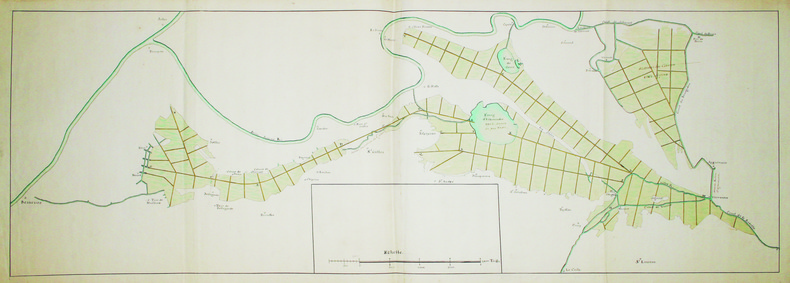
AIGUES-MORTES. MANUSCRIT.
[Carte des marais et canaux entre Arles et Aigues-Mortes].
[circa 1750]. En 2 feuilles jointes de 0,39 x 1,12 m.
Référence libraire : LBW-4159
|
|
|
AIGUES-MORTES. MANUSCRIT.
[Fort de Peccais et marais salant de l’Abbé].
[circa 1720]. 430 x 384 mm.
Référence libraire : LBW-4143

|
|
|
AIGUES-MORTES. MANUSCRIT.
Plan géométrique du domaine de Labadier appartenant à Mrs les héritiers de Louis Mourgues.
[circa 1840]. 543 x 725 mm, sur papier calque et monté sur papier.
Référence libraire : LBW-4153

|
|
|
AIN
Carte d?partementale couleurs au 1/200 000?.
Une feuille 55x74 cm.
|
|
|
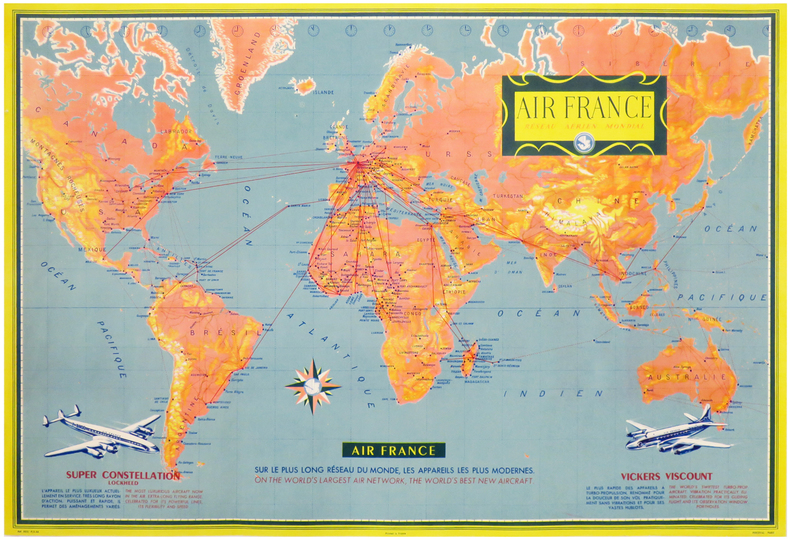
AIR FRANCE.
AIR FRANCE. Réseau Aérien Mondial.
Paris, Perceval, 1956. Lithographie en couleurs de 477 x 704 mm.
Référence libraire : LBW-3313
|
|
|
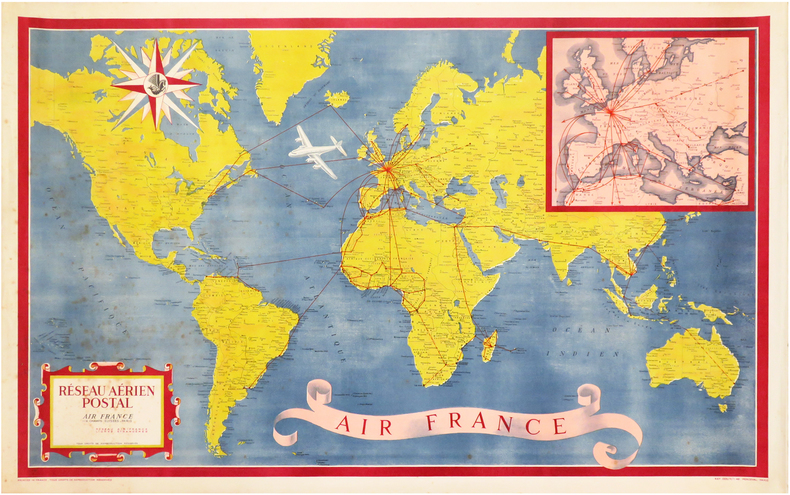
AIR FRANCE.
Réseau Aérien Postal. Air France.
Paris, Perceval, 1948. Lithographie en couleurs de 585 x 955 mm.
Référence libraire : LBW-3312
|
|
|
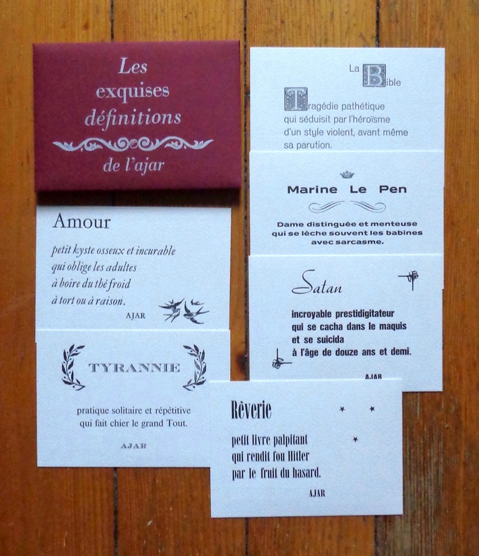
AJAR:
Les exquises définitions de l'ajar.
l'AJAR / L'atelier du Cadratin, 2012. 6 cartes postales - au format carte postale, faisons simple - sous pochette bordeaux avec titre argenté. A l'état de neuf.
Référence libraire : 6334
|
|
|
Akiyama, C.; Akiyama, N.
Learn Japanese the Fast and Fun Way (Fast and Fun Way Language Bks.)
234 pages plus vocabulary cards. The activity kit that makes learning a language quick and easy! Complete with maps, puzzles, and quizzes. Hundreds of amusing illustrations. Please note: does not include pull-out dictionary. First half of book has pencil markings in answer blanks. Light wear. Nice copy. Book
|
|
|
AL IDRISI - Miller, Konrad
Weltkarte des Arabers Idrisi vom Jahre 1154. Neudruck des 1928 erschienen Werkes.
Brockhaus / Antiquarium Stuttgart 1981. 22 Textseiten und eine vielfach gefaltete, farbige Karte, gefalzt in 3 Teilen. (linker Teil, mittlerer Teil und rechter Teil) zusammen in Original-Leinwand-Einband mit farbig mont. Abbildung. (Geringe Gebrauchsspuren. Einband etwas randfleckig) 33x25,5 cm
Référence libraire : 146393

|
|
|
ALAIN BRÊTHES ( BRÊTHE )
L'INTERPRETATION DES ARCANES MAJEURS
Broché - 15,5 x 25 - 308 pp - année 2001 - Editions Oriane - illustrations
Référence libraire : 16521

|
|
|
Alain Marc Adolphe Germaine
Sudoku ninja niveau 1: L'éveil du dragon
BRAVO 2009 322 pages 10 8x2 2x16 4cm. 2009. mass_market. 322 pages.
Référence libraire : 500106015

|
|
|
Alain Marc Adolphe Germaine
Sudoku ninja niveau 1: L'éveil du dragon
BRAVO 2009 322 pages 10 8x2 2x16 4cm. 2009. mass_market. 322 pages.
Référence libraire : 500136605

|
|
|
Alan Godfrey Maps
Belfast East 1901: Co Down Sheet 4.11 Old Ordnance Survey Maps of County Down
1997-12-01. Good. Ships with Tracking Number! INTERNATIONAL WORLDWIDE Shipping available. May not contain Access Codes or Supplements. May be re-issue. May be ex-library. Shipping & Handling by region. Buy with confidence excellent customer service! unknown
Référence libraire : 0850549361 ISBN : 0850549361 9780850549362

|
|
|
Alan Godfrey Maps
Belfast Shankill 1901: Co Antrim Sheet 60.08 Old Ordnance Survey Maps of County Antrim
2000-03-15. Good. Ships with Tracking Number! INTERNATIONAL WORLDWIDE Shipping available. May not contain Access Codes or Supplements. May be re-issue. May be ex-library. Shipping & Handling by region. Buy with confidence excellent customer service! unknown
Référence libraire : 184151151X ISBN : 184151151x 9781841511511

|
|
|
Alan Godfrey Maps
Birmingham South 1913: Warwickshire Sheet 14.09 Old Ordnance Survey Maps of Warwickshire
1996-03-01. Good. Ships with Tracking Number! INTERNATIONAL WORLDWIDE Shipping available. May not contain Access Codes or Supplements. May be re-issue. May be ex-library. Shipping & Handling by region. Buy with confidence excellent customer service! unknown
Référence libraire : 0850547946 ISBN : 0850547946 9780850547948

|
|
|
Alan Godfrey Maps
Blackburn 1910: Lancashire Sheet 62.16a Old O.S. Maps of Lancashire
1986-08-02. Good. Ships with Tracking Number! INTERNATIONAL WORLDWIDE Shipping available. May not contain Access Codes or Supplements. May be re-issue. May be ex-library. Shipping & Handling by region. Buy with confidence excellent customer service! unknown
Référence libraire : 0850540844 ISBN : 0850540844 9780850540840

|
|
|
Alan Godfrey Maps
Calderdale and Huddersfield 1902: One Inch Sheet 077 Old Ordnance Survey Maps - Inch to the Mile
2000-07-22. Good. Ships with Tracking Number! INTERNATIONAL WORLDWIDE Shipping available. May not contain Access Codes or Supplements. May be re-issue. May be ex-library. Shipping & Handling by region. Buy with confidence excellent customer service! unknown
Référence libraire : 1841511889 ISBN : 1841511889 9781841511887

|
|
|
Alan Godfrey Maps
Cradley Heath and Old Hill 1901: Staffordshire Sheet 71.08 Old O.S. Maps of Staffordshire
1995-05-01. Good. Ships with Tracking Number! INTERNATIONAL WORLDWIDE Shipping available. May not contain Access Codes or Supplements. May be re-issue. May be ex-library. Shipping & Handling by region. Buy with confidence excellent customer service! unknown
Référence libraire : 0850547318 ISBN : 0850547318 9780850547313

|
|
|
Alan Godfrey Maps.
Crystal Palace 1871: Kent Sheet 7.10 Old Ordnance Survey Maps
Gateshead: Alan Godfrey Maps. 1990. First edition thus. Paperback. Very Good. undated Alan Godfrey Maps. paperback
Référence libraire : 500038880
|
|
|
Alan Godfrey Maps
Edinburgh Holyrood 1894: Edinburgh Sheet 3.08 Old O.S. Maps of Edinburgh
1984-09-01. Good. Ships with Tracking Number! INTERNATIONAL WORLDWIDE Shipping available. May not contain Access Codes or Supplements. May be re-issue. May be ex-library. Shipping & Handling by region. Buy with confidence excellent customer service! unknown
Référence libraire : 0907554768 ISBN : 0907554768 9780907554769

|
|
|
Alan Godfrey Maps
Fleet Street and the Strand 1874: London Large Scale Sheet 07.64 Old Ordnance Survey Maps of London - Yard to the Mile
1995-05-01. Good. Ships with Tracking Number! INTERNATIONAL WORLDWIDE Shipping available. May not contain Access Codes or Supplements. May be re-issue. May be ex-library. Shipping & Handling by region. Buy with confidence excellent customer service! unknown
Référence libraire : 0850547334 ISBN : 0850547334 9780850547337

|
|
|
Alan Godfrey Maps
Great Malvern and West Malvern 1926: Worcestershire Sheet 39.12 Old Ordnance Survey Maps of Worcestershire
2004-03-01. Good. Ships with Tracking Number! INTERNATIONAL WORLDWIDE Shipping available. May not contain Access Codes or Supplements. May be re-issue. May be ex-library. Shipping & Handling by region. Buy with confidence excellent customer service! unknown
Référence libraire : 1841516228 ISBN : 1841516228 9781841516226
|
|
|
Alan Godfrey Maps
Prestwich 1915: Lancashire Sheet 96.09 Old O.S. Maps of Lancashire
2004-11-17. New. Ships with Tracking Number! INTERNATIONAL WORLDWIDE Shipping available. May be re-issue. Buy with confidence excellent customer service! unknown
Référence libraire : 1841517208n ISBN : 1841517208 9781841517209

|
|
|
Alan Godfrey Maps
Prestwich 1915: Lancashire Sheet 96.09 Old O.S. Maps of Lancashire
2004-11-17. Good. Ships with Tracking Number! INTERNATIONAL WORLDWIDE Shipping available. May not contain Access Codes or Supplements. May be re-issue. May be ex-library. Shipping & Handling by region. Buy with confidence excellent customer service! unknown
Référence libraire : 1841517208 ISBN : 1841517208 9781841517209

|
|
|
Alan Godfrey Maps
Shoreditch 1872: London Sheet 051.1 Old Ordnance Survey Maps of London
1987-10-01. Good. Ships with Tracking Number! INTERNATIONAL WORLDWIDE Shipping available. May not contain Access Codes or Supplements. May be re-issue. May be ex-library. Shipping & Handling by region. Buy with confidence excellent customer service! unknown
Référence libraire : 0850541247 ISBN : 0850541247 9780850541243
|
|
|
Alan Godfrey Maps
West India Docks 1867: London Sheet 079.1 Old O.S. Maps of London
1992-01-01. Good. Ships with Tracking Number! INTERNATIONAL WORLDWIDE Shipping available. May not contain Access Codes or Supplements. May be re-issue. May be ex-library. Shipping & Handling by region. Buy with confidence excellent customer service! unknown
Référence libraire : 0850544661 ISBN : 0850544661 9780850544664

|
|
|
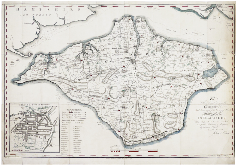
ALBIN (John).
[ÎLE de WIGHT] To the Right Honorable Lord Bolton, Lord Lieutenant of the county of Hants & governor of the isle of Wight.
Newport, Isle of Wight, J. Albin, 1802. 393 x 584 mm.
Référence libraire : LBW-6386
|
|
|
ALBARRAN Pierre, Robert DE NEXON, José LE DENTU
Le nouveau bridge pour tous.
relié avec jacquette - 14,5x19,5 - 388 pp - 1965 - éditions ARTHEME FAYARD, Paris.Nouvelle édition revue et corrigée.
Référence libraire : 6595
|
|
|
ALBARRAN Pierre
Le nouveau bridge pour tous.
Paris, Fayard, 1958 14 x 20, 396 pp., cartonnage + jaquette (défraîchie), bon état
Référence libraire : 3206
|
|
|
Albert Dupaigne
Les Montagnes (cartes en couleurs)
Alfred Mame et fils, Tours, 1877. In-8 relié percaline verte, dos à 5 nerfs orné, plats percaline rouge, encadrement estampé à froid sur les plats, toutes tranches dorées, 592 pages. Ouvrage illustré de sept cartes en couleur hors-texte (dessinées par Dumas-Vorzet et gravées par Erhard) et de 184 figures noires in-texte et hors-texte dont le frontispice par Riou, Bayard, Weil... Sommaire: Introduction - Pays de plaines et pays de montagnes -Une science méconnue - Où sont les montagnes - Les formes des montagnes - De quoi sont faites les montagnes - L'origine des montagnes - La géologie - Deux pages de la Genèse - Les volcans - L'atmosphère et ses météores - La circulation des eaux - La démolition des montagnes - Les glaciers - La vie dans les montagnes - Conclusion.
Référence libraire : PPP-315

|
|
|
ALBARRAN (P.) et NEXON (R. de).-
Notre méthode de bridge. Edition revue, corrigée et augmentée 1948.
P., Grasset, 1950, in 8° broché, 249 pages (en partie non coupé) ; couverture illustrée en couleurs.
Référence libraire : 27373
|
|
|
ALBARRAN-SVARC Simone et LE DENTU José
Nouveau mémento de bridge en 100 leçons, enchères naturelles.
Paris, Fayard, 1976 13 x 21, 108 pp., broché, bon état
Référence libraire : 8288
|
|
|
ALBARRAN Pierre - DE NEXON Robert
Le bridge pour tous. Le jeu de la carte par José Le Dentu.
Cartonnage de l'éditeur. 380 pages.
|
|
|
ALBRIZZI Giambattista (Venezia 1698 - 1777)
Mappamondo o sia Descrizione Generale del Globo Terrestre ed Acquatico
Mappa del mondo tratta dall’Atlante Novissimo, edito da Giambattista Albrizzi, nel 1740 circa; una delle più interessanti e decorative carte del mondo che compaiono in un Atlante della metà del Settecento italiano. Elegante esempio della scuola italiana di cartografia commerciale; la decorazione intorno alla carta è stata realizzata da Giovanni Battista Piazzetta (1682-1754 ca.), la cui influenza è visibile nella successiva opera di Antonio Zatta e di altri editori veneziani del ‘700. Il contenuto cartografico della carta, che è tratto dal Mappe Monde di De l'Isle (1700), è circondato da allegorie femminili in ogni angolo che rappresentano i quattro continenti, delle quali il Piazzetta è il disegnatore e Giuliano Giampiccoli l’incisore. La mappa comprende una sfera armillare, le rotte dell'esploratore, la sconosciuta costa nord-occidentale dell'America, le proiezioni incomplete dell'Australia (ancora attaccata alla Nuova Guinea) e della Nuova Zelanda, la congiunzione della massa della Terra Asiatica che si estende verso l'Alaska e molti altri miti cartografici e proiezioni errate. Acquaforte, finemente colorata a mano, in ottime condizioni. Map of the World taken from Atlante Novissimo, published by Giambattista Albrizzi, circa 1740. Globe with allegorical representations of the four continents in the corners, surmounted by an armillary sphere. Striking example of Albrizzi's double hemipshere map of the World, one of the most interesting and decorative world maps to appear in a mid-18th Italian Century Atlas. An elegant example of the Italian school of commercial cartography, the art work around the map having been done by important Italian artist Giovanni Battista Piazzetta (ca. 1682-1754), whose influence can be seen in the subsequent work of Zatta and others. The cartographic content of the map, which is drawn from De l'Isle's Mappe Monde (1700), is secondary to the very beautiful, serene female figures in each corner representing the four continents. G. Batta Piaceta is shown as Inventor (left), and Guliano Giampicoli, as engraver (right). The map includes a finley executed armillary sphere, explorer's routes, unknown NW Coast of America, incomplete projections of Australia (still attached to New Guinea) and New Zealand, conjectural Asian Land mass extending toward Alaska and many other cartographic myths and misprojections. Copperplate with fine later hand colour, very good condition.

|
|
|
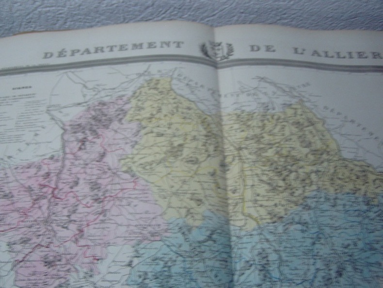
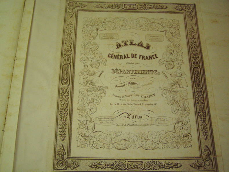
Alexis Donnet DONNET ,FREMIN et LEVASSEUR ou DONNET and MONIN
Carte du Département de l'ALLIER avec vue de Moulin dréssée par Donnet
1841 1841 à paris ,chez DUSSILLON ,rue Lafitte ,gravure sur acier avec limites coloriées par les fréres Malo,Extr. de l'Atlas des Départemens de la France, par M. Donnet, Frémin et Levasseur.- Atlas des départements de la France (délimitation par cantons) / par A. Donnet, Frémin & Levasseur ; revue par Granger
Référence libraire : 2768
|
|
|
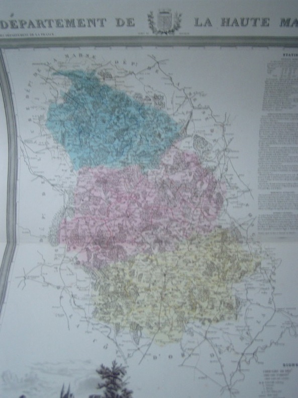
Alexis Donnet DONNET ,FREMIN et LEVASSEUR ou DONNET and MONIN- DONNET (Alexis) & FRÉMIN (Antoine-Rémy).
Carte du Département de la HAUTE-MARNE avec vue de Chaumont dréssée par Donnet
1841 1841 à paris ,chez DUSSILLON ,rue Lafitte ,gravure sur acier avec limites coloriées par les fréres Malo,Extr. de l'Atlas des Départemens de la France, par M. Donnet, Frémin et Levasseur.Alexis Donnet était un ingénieur-géographe attaché au Cadastre de la France. Élève de Bacler d'Albe, il fut à l'origine d'une abondante œuvre cartographique souvent rééditée. À ses cartes de France et des environs de Paris s'ajoutent des cartes de l'Italie et de la péninsule ibérique, et des cartes concernant les nouvelles lignes de chemins de fer. Antoine-Rémy Frémin était un géographe attaché au Dépôt général de la Guerre. Victor Levasseur était un ingénieur-géographe et géomètre attaché au Génie du Cadastre et de la Ville de Paris, et membre de la Société de Géographie. Bel exemplaire, contours aquarellés à l'époque.
Référence libraire : 2769
|
|
|
Alexis Donnet DONNET ,FREMIN et LEVASSEUR ou DONNET and MONIN
Carte du Département de la NIEVRE avec vue de Nevers dréssée par Donnet
1841 1841 à paris ,chez DUSSILLON ,rue Lafitte ,gravure sur acier avec limites coloriées par les fréres Malo,Extr. de l'Atlas des Départemens de la France, par M. Donnet, Frémin et Levasseur.
Référence libraire : 2770

|
|
|
Alexis Donnet DONNET ,FREMIN et LEVASSEUR ou DONNET and MONIN
Carte du Département des ARDENNES avec vue de Mézieres dréssée par Donnet
1841 1841 à paris ,chez DUSSILLON ,rue Lafitte ,gravure sur acier avec limites coloriées par les fréres Malo,Extr. de l'Atlas des Départemens de la France, par M. Donnet, Frémin et Levasseur.
Référence libraire : 2771
|
|
|
Alexis Donnet DONNET ,FREMIN et LEVASSEUR ou DONNET and MONIN- DONNET (Alexis) & FRÉMIN (Antoine-Rémy).
Carte du Département du DOUBS avec vue de Besançon dréssée par Donnet
1841 1841 à paris ,chez DUSSILLON ,rue Lafitte ,gravure sur acier avec limites coloriées par les fréres Malo,Extr. de l'Atlas des Départemens de la France, par M. Donnet, Frémin et Levasseur.
Référence libraire : 2772

|
|
|
Alexis Donnet DONNET ,FREMIN et LEVASSEUR ou DONNET and MONIN
Carte du Département de l' AUBE avec vue de Troyes dréssée par Donnet
1841 1841 à paris ,chez DUSSILLON ,rue Lafitte ,gravure sur acier avec limites coloriées par les fréres Malo,Extr. de l'Atlas des Départemens de la France, par M. Donnet, Frémin et Levasseur.
Référence libraire : 2774

|
|
|
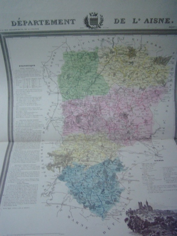
Alexis Donnet DONNET ,FREMIN et LEVASSEUR ou DONNET and MONIN
Carte du Département de l'AISNE avec vue de Laon dréssée par Donnet
1841 1841 à paris ,chez DUSSILLON ,rue Lafitte ,gravure sur acier avec limites coloriées par les fréres Malo,Extr. de l'Atlas des Départemens de la France, par M. Donnet, Frémin et Levasseur.
Référence libraire : 2775
|
|
|
Alexis Donnet DONNET ,FREMIN et LEVASSEUR ou DONNET and MONIN
Carte du Département de l'ILLE et VILAINE avec vue de Rennes dréssée par Donnet
1841 1841 à paris ,chez DUSSILLON ,rue Lafitte ,gravure sur acier avec limites coloriées par les fréres Malo,Extr. de l'Atlas des Départemens de la France, par M. Donnet, Frémin et Levasseur.
Référence libraire : 2777

|
|
|
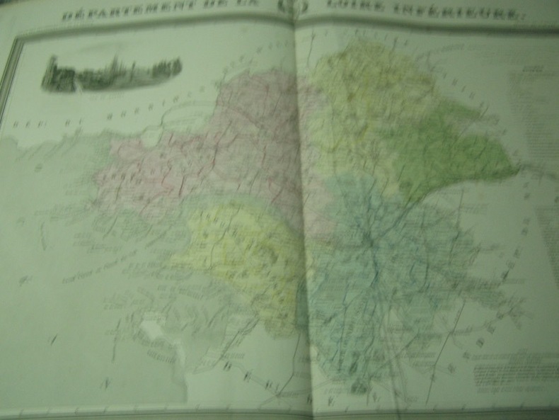
Alexis Donnet DONNET ,FREMIN et LEVASSEUR ou DONNET and MONIN
Carte du Département de la LOIRE INFERIEURE avec vue de Nantes dréssée par Donnet
1841 1841 à paris ,chez DUSSILLON ,rue Lafitte ,gravure sur acier avec limites coloriées par les fréres Malo,Extr. de l'Atlas des Départemens de la France, par M. Donnet, Frémin et Levasseur.
Référence libraire : 2778
|
|
|
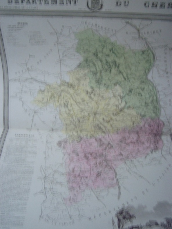
Alexis Donnet DONNET ,FREMIN et LEVASSEUR ou DONNET and MONIN
Carte du Département du CHER avec vue de Bourges dréssée par Donnet
1841 1841 à paris ,chez DUSSILLON ,rue Lafitte ,gravure sur acier avec limites coloriées par les fréres Malo,Extr. de l'Atlas des Départemens de la France, par M. Donnet, Frémin et Levasseur.
Référence libraire : 2779
|
|
|
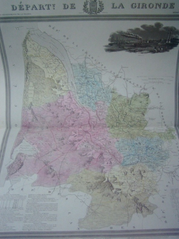
Alexis Donnet DONNET ,FREMIN et LEVASSEUR ou DONNET and MONIN- DONNET (Alexis) & FRÉMIN (Antoine-Rémy) & MONIN (Charles V.).
Carte du Département de la GIRONDE avec vue de Bordeaux dréssée par Donnet
1841 1841 à paris ,chez DUSSILLON ,rue Lafitte ,gravure sur acier avec limites coloriées par les fréres Malo,Extr. de l'Atlas des Départemens de la France, par M. Donnet, Frémin et Levasseur.
Référence libraire : 2780
|
|
 Recevoir par e-mail
 Télécharger en PDF
 Flux RSS


