|
Bodenehr, Gabriel
Europens Pracht und Macht. 2 Teile in einem Band. REPRINT der Ausgabe Augsburg, Bodenehr, um 1710.
(Unterschneidheim, Walter Uhl, 1972). 200, 100 oft gefalt. s/w Taf. Quer-Folio. 27,5 x 37,5 cm. OLn.
Référence libraire : 93929

|
|
|
Bodenehr, Gabriel
Force de l'Europe oder die merckwurdigst und furnehmste, meistentheils auch ihrer Fortification wegen berühmteste Staette, Vestungen, Seehaefen, Paesse, Camps de Bataille in Europa, welche ihren Königreichen und Landschafften in Fridens Zeiten zu Nuz und Zier, in Kriegs Läufften zum Schuz und Wehr dienen ... Verlegt u. hrsg. von Gabriel Bodenehr. REPRINT der Ausgabe Augsburg [um 1700]. 2 Bde. in einem Band.
(Unterschneidheim, Walter Uhl, 1972). 200, 100 oft gefalt. s/w Taf. Quer-Folio. 27,5 x 37,5 cm. OLn.
Référence libraire : 93928

|
|
|
Bogdanos Matthew with Patrick William/Sinclair James maps/diagrams
Thieves of Baghdad: One Marine's Passion for Ancient Civilizations and the Journey to Recover the World's Greatest Stolen Treasures
NY: Bloomsbury 2005. 1st American printing. Fine/Fine dust jacket. vi 305 p. color photos maps diagrams notes biblio 8vo; Bloomsbury hardcover
Référence libraire : 52211 ISBN : 1582346453 9781582346458

|
|
|
Bogdanos Matthew AUTOGRAPHED with Patrick William/Sinclair James maps/diagrams
Thieves of Baghdad: One Marine's Passion for Ancient Civilizations and the Journey to Recover the World's Greatest Stolen Treasures
NY: Bloomsbury 2005. 1st American printing. VG/VG dust jacket. SIGNED BY AUTHOR vi 305 p. color photos maps diagrams notes biblio 8vo; Bloomsbury hardcover
Référence libraire : 47415 ISBN : 1582346453 9781582346458
|
|
|
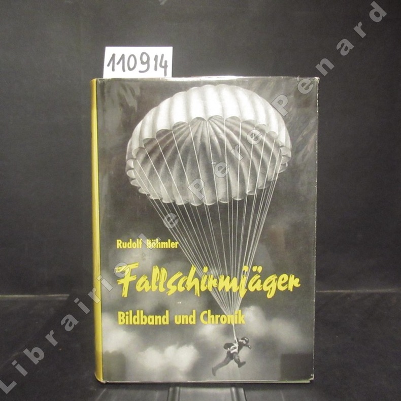
BOHMLER, Rudolf
Fallschirmjäger. Bildband und Chronik.
1961 Editions Podzun-Verlag Bad Nauheim - 1961 - In-8, cartonnage toilé vert avec décoration en doré sur le premier plat et titre en doré au dos sous jaquette illustrée - 497 p. - Reproductions photographiques en N&B in et hors-texte - Ouvrage en allemand
Référence libraire : 110914
|
|
|
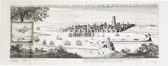
BOISSEAU (Jean).
[DUNKERQUE] Profil ou nouvelle description de la ville maritime port et havre de Dunquerque, au comté de Flandre.
Paris, Jean Boisseau, 1642-1648. En deux feuilles jointes de 270 x 691 mm.
Référence libraire : LBW-612
|
|
|
BOISSEAU (Jean).
[FORET de FONTAINEBLEAU] Nouvelle description de la forest royalle de Fontaine Belleau.
circa 1650. 353 x 483 mm.
Référence libraire : LBW-1908

|
|
|
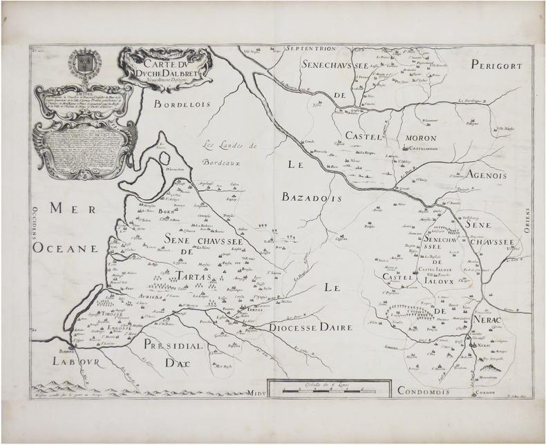
BOISSEAU (Jean).
[GASCOGNE] Carte du duché d'Albret nouvellement deseigné.
[Paris], 1647. 378 x 538 mm.
Référence libraire : LBW-8124
|
|
|
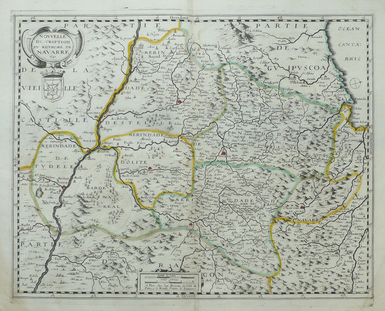
BOISSEAU (Jean).
[NAVARRE] Nouvelle description du royaume de Navarre.
Paris, 1642. 375 x 480 mm.
Référence libraire : LBW-1490
|
|
|
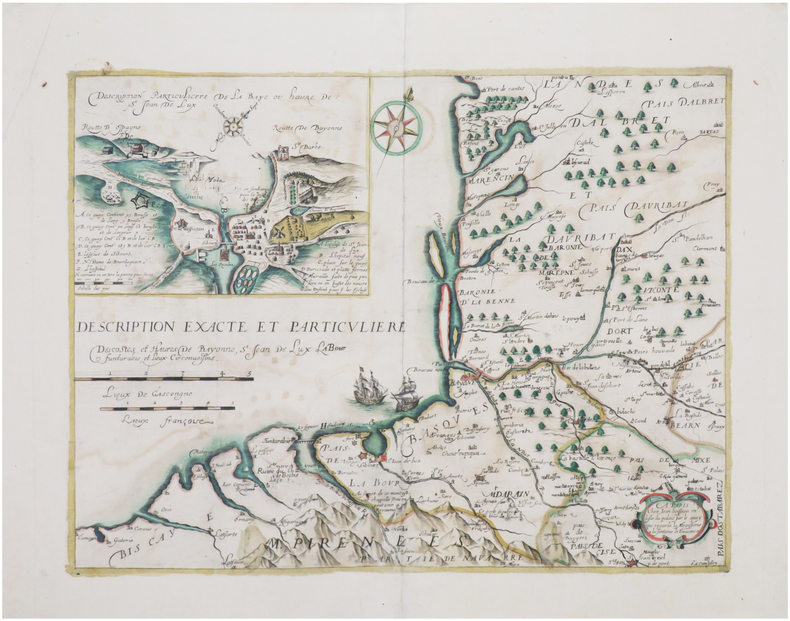
BOISSEAU (Jean).
[PAYS BASQUE] Description exacte et particulière des costes et havres de Bayonne, St. Jean de Lux, Labour, Funtarabie, et lieux circonvoisins.
[Paris, 1642]. 335 x 450 mm.
Référence libraire : LBW-8043
|
|
|
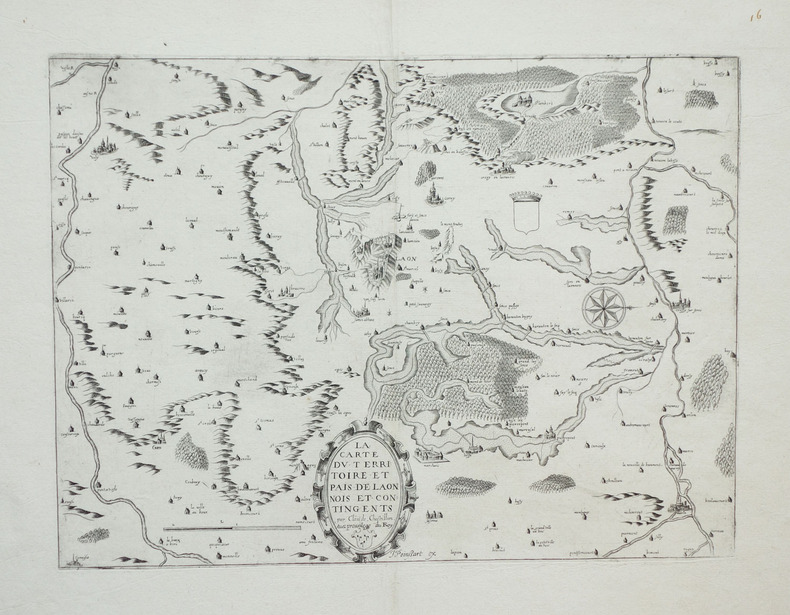
BOISSEAU (Jean) & CHASTILLON (Claude de).
[PICARDIE] La carte du territoire et pais de Laonnois et contingents.
Paris, 1642. 269 x 366 mm.
Référence libraire : LBW-1893
|
|
|
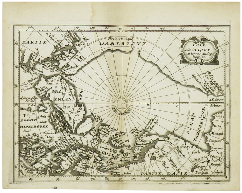
BOISSEVIN (Louis).
[PÔLE NORD] Pôle Arctique ou terres du septentrion.
[Paris, Louis Boissevin, 1653]. 142 x 198 mm.
Référence libraire : LBW-6174
|
|
|
BOISSEAU (Jean).
Carte de la France divisée par les provinces de l'esglise galicane.
Paris, Jean Boisseau, 1642. 357 x 487 mm.
Référence libraire : LBW-8143

|
|
|
BOITE CARTES LECTURE
CARTES A LIRE 3E ANNEE ANAPHORES
PASSE-TEMPS EDITIONS
Référence libraire : SVBLIVCN-9830096008335
|
|
|
BOITE CARTES LECTURE
CARTES A LIRE 3E ANNEE VOCABULAIRE
PASSE-TEMPS EDITIONS
Référence libraire : SVBLIVCN-9830096008342
|
|
|
BOITE CARTES LECTURE
CARTES A LIRE 3E ANNEE INFERENCES
PASSE-TEMPS EDITIONS
Référence libraire : SVBLIVCN-9830096008311
|
|
|
BOITE CARTES LECTURE
CARTES A LIRE 3E ANNEE PREDICTIONS
PASSE-TEMPS EDITIONS
Référence libraire : SVBLIVCN-9830096008328
|
|
|
BOITE CARTES LECTURE
CARTES A LIRE 1RE ANNEE ANAPHORES
PASSE-TEMPS EDITIONS
Référence libraire : SVBLIVCN-9830096008199
|
|
|
BOITE CARTES LECTURE
CARTES A LIRE 1RE ANNEE PREDICTIONS
PASSE-TEMPS EDITIONS
Référence libraire : SVBLIVCN-9830096008182
|
|
|
BOITE CARTES LECTURE
CARTES A LIRE 1RE ANNEE VOCABULAIRE
PASSE-TEMPS EDITIONS
Référence libraire : SVBLIVCN-9830096008205
|
|
|
BOITE CARTES LECTURE
CARTES A LIRE 1RE ANNEE INFERENCES
PASSE-TEMPS EDITIONS
Référence libraire : SVBLIVCN-9830096008175
|
|
|
BOITE CARTES LECTURE
CARTES A LIRE 2E ANNEE IDEE PRINCIPALE
PASSE-TEMPS EDITIONS
Référence libraire : SVBLIVCN-9830096008229
|
|
|
BOITE CARTES LECTURE
CARTES A LIRE 1RE ANNEE IDEE PRINCIPALE
PASSE-TEMPS EDITIONS
Référence libraire : SVBLIVCN-9830096008151
|
|
|
BOITE CARTES LECTURE
CARTES A LIRE 1RE ANNEE REPERAGE
PASSE-TEMPS EDITIONS
Référence libraire : SVBLIVCN-9830096008168
|
|
|
BOITE CARTES LECTURE
CARTES A LIRE 2E ANNEE REPERAGE
PASSE-TEMPS EDITIONS
Référence libraire : SVBLIVCN-9830096008236
|
|
|
BOITE CARTES LECTURE
CARTES A LIRE 2E ANNEE INFERENCES
PASSE-TEMPS EDITIONS
Référence libraire : SVBLIVCN-9830096008243
|
|
|
BOITE CARTES LECTURE
CARTES A LIRE 2E ANNEE PREDICTIONS
PASSE-TEMPS EDITIONS
Référence libraire : SVBLIVCN-9830096008250
|
|
|
BOITE CARTES LECTURE
CARTES A LIRE 2E ANNEE ANAPHORES
PASSE-TEMPS EDITIONS
Référence libraire : SVBLIVCN-9830096008267
|
|
|
BOITE CARTES LECTURE
CARTES A LIRE 2E ANNEE VOCABULAIRE
PASSE-TEMPS EDITIONS
Référence libraire : SVBLIVCN-9830096008274
|
|
|
BOITES CARTES LECTURE
CARTES A LIRE 3E ANNEE IDEE PRINCIPALE
PASSE-TEMPS EDITIONS
Référence libraire : SVBLIVCN-9830096008298
|
|
|
BOITE CARTES LECTUREE
CARTES A LIRE 3E ANNEE REPERAGE
PASSE-TEMPS EDITIONS
Référence libraire : SVBLIVCN-9830096008304
|
|
|
BOITES 80 CARTES JEU
COMPREHENSION EN LECTURE 6E ANNEE
L'ENVOLEE (CA)
Référence libraire : SVBLIVCN-9782894885765
|
|
|
BOITES 80 CARTES JEU
COMPREHENSION EN LECTURE 5E ANNEE
L'ENVOLEE (CA)
Référence libraire : SVBLIVCN-9782894885741
|
|
|
BOILLOT-ROBERT J.; RENAUD G:
De Bâle à Brigue et Zermatt: Guide illustré du réseau du Jura-Simplon.
Lausanne-Zurich, François-Martin Wohlgroth, sans date [1895]. In-4 à l'italienne de 49 planches suivies de 74 et 54 pages, pleine percaline rouge d'éditeur illustrée, plats biseautés, tranches dorées.
Référence libraire : 17618

|
|
|
boisseranc ( claudine ) bayle ( georges )
les hautes-alpes d'antan
les provinciales curendera 1989 in 4 broché (30cmX21cm) 143 pages tres nombreuses illustrations par la carte postale
Référence libraire : 1804

|
|
|
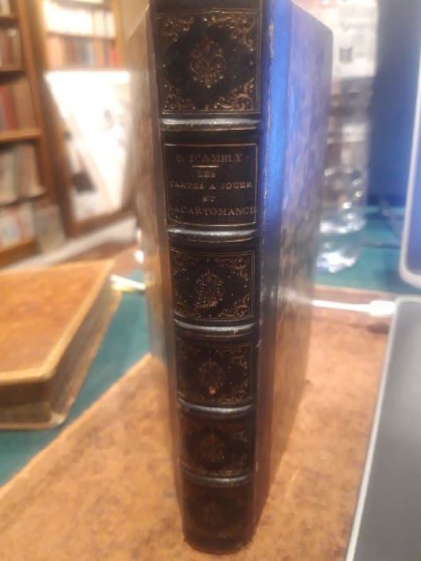
Boiteau d'Ambly,P.
Les cartes à jouer et la cartomancie
Paris, Librairie de L.Hachette 1854 1 in -8 Demi chagrin 386[p.p]
Référence libraire : LCI-4056
|
|
|
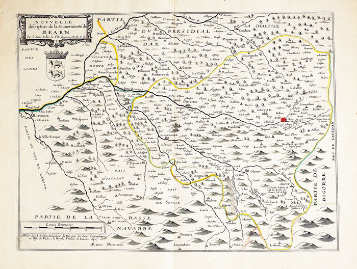
BOISSEAU (Jean).
Nouvelle description de la souveraineté de Béarn.
Paris, J. Boisseau, 1642. 346 x 463 mm.
Référence libraire : LBW-562
|
|
|
BOITE JEUX DE CARTES -ENSEMBLE 3-
ORTHOGRAPHE SANS PAPIER NI CRAYON 10-12 ANS
CHENELIERE EDUCATION (CA)
Référence libraire : SVBLIVCN-9782765051565
|
|
|
BOITE JEUX DE CARTES -ENSEMBLE 1-
ORTHOGRAPHE SANS PAPIER NI CRAYON 6-8 ANS
CHENELIERE EDUCATION (CA)
Référence libraire : SVBLIVCN-9782765051541
|
|
|
BOITE JEUX DE CARTES -ENSEMBLE 2-
ORTHOGRAPHE SANS PAPIER NI CRAYON 8-10 ANS
CHENELIERE EDUCATION (CA)
Référence libraire : SVBLIVCN-9782765051558
|
|
|
BOLL (Marcel).-
La chance et les jeux de hasard. Loterie - Boule - Roulettes - Baccar - 30 et 40 - Dés - Bridge - Poker - Belote - Ecarté - Piquet - Manille.
P., Librairie Larousse, 1936, fort in 8° broché, 382 pages ; couverture illustrée en couleurs, fanée avec petites déchirures avec manques ; 20 premières pages "rongées" à un angle.
Référence libraire : 51488
|
|
|
BOLDENYI M. J. (dir.):
La Hongrie ancienne et moderne. Histoire, arts, littératures, monuments. Par une société de littérateurs.
Paris, H. Lebrun, 1851. 2 tomes en 1 volume in-4 de 239, 159 pages, demi-chagrin marron à coins, dos à nerfs orné. Quelques rousseurs.
Référence libraire : 2049
|
|
|
Bolivar Simon Trend JB. and Maps on End Papers J. B.
Bolivar and the Independence of Spanish America Teach Yourself History Series
Hardcover. Good. hardcover
Référence libraire : 715896
|
|
|
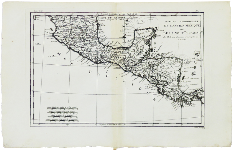
BONNE (Rigobert).
[AMÉRIQUE CENTRALE] Partie méridionale de l'ancien Méxique ou de la Nouv.le Espagne.
[1780]. 211 x 318 mm.
Référence libraire : LBW-5900
|
|
|
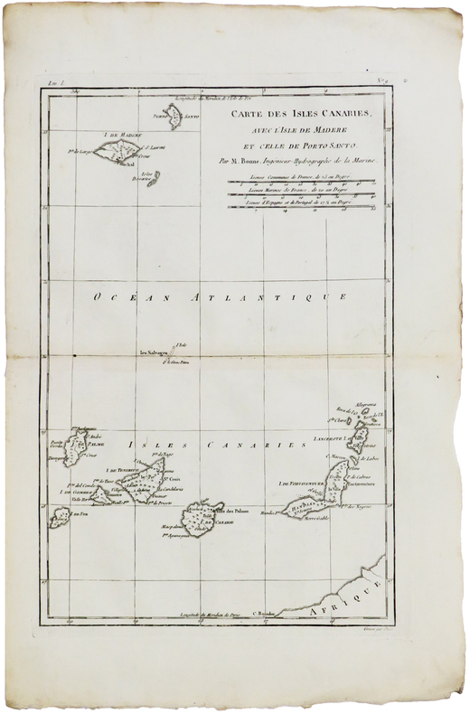
BONNE (Rigobert).
[CANARIES & MADÈRE] Carte des isles Canaries, avec l'isle de Madère et celle de Porto Santo.
[1780]. 320 x 211 mm.
Référence libraire : LBW-5941
|
|
|
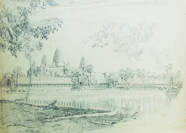
BONNIGAL (Paul).
[CAMBODGE] Vue panoramique d'Angkor Vat.
[vers 1915]. Dessin original sur papier de 58,5 x 42,5 cm.
Référence libraire : LBW-6621
|
|
|
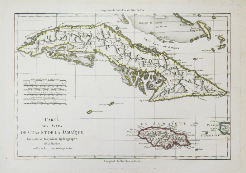
BONNE (Rigobert).
[CUBA/JAMAÏQUE] Carte des isles de Cuba et de la Jamaïque.
1782. 223 x 320 mm.
Référence libraire : LBW-3727
|
|
|
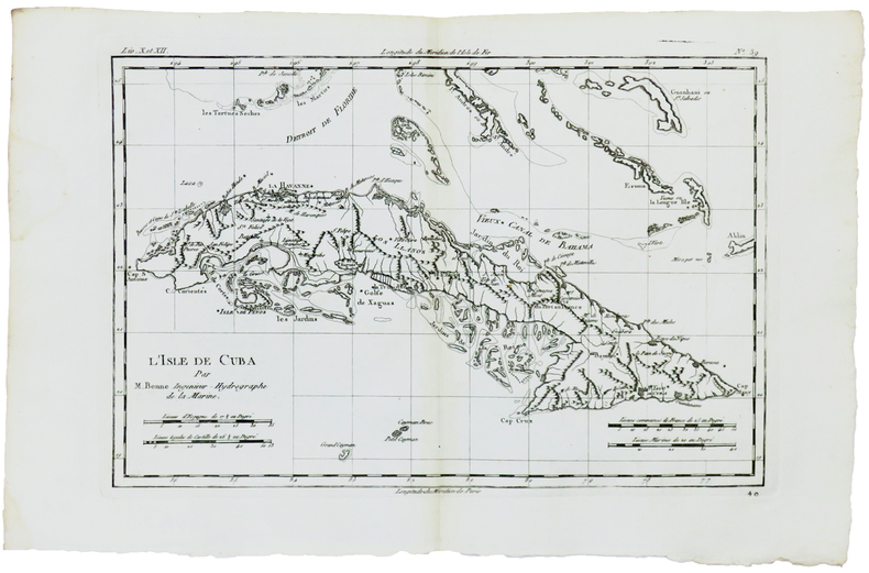
BONNE (Rigobert).
[CUBA] L'isle de Cuba.
[1780]. 214 x 316 mm.
Référence libraire : LBW-5930
|
|
|
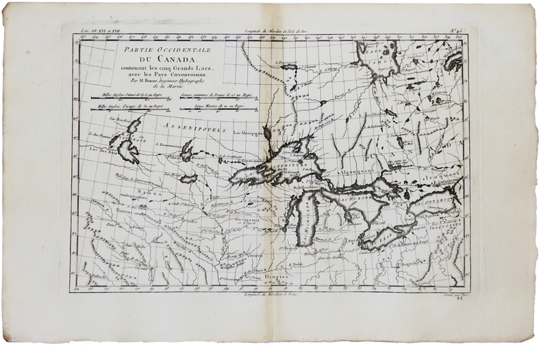
BONNE (Rigobert).
[GRANDS LACS] Partie occidentale du Canada, contenant les cinq Grands Lacs, avec les pays circonvoisins.
[1780]. 212 x 314 mm.
Référence libraire : LBW-5929
|
|
|
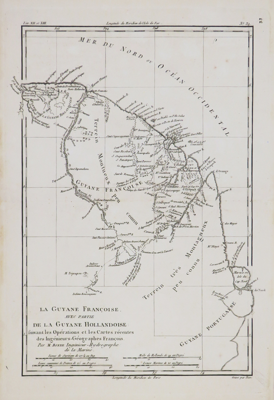
BONNE (Rigobert).
[GUYANE] La Guyane Françoise, avec partie de la Guyane Hollandoise.
[circa 1770]. 322 x 230 mm.
Référence libraire : LBW-4789
|
|
 Recevoir par e-mail
 Télécharger en PDF
 Flux RSS


