|
BOURGOGNE André
LE MORVAN A LA BELLE EPOQUE.
Chez l'auteur, 1981. In-4 broché, couverture illustrée, 122 pagesalbum abondamment illustré de cartes postales anciennes du morvan. Très bon état. Tirage limité à 2000 exemplaires, celui-ci le n° 42.
Referencia librero : 9910
|
|
|
BOURGOGNE FRANCHE-COMTE
Carte de la Bourgogne et de la Franche-Comté.
Paris s.n. 1763 290 x 410 mm
Referencia librero : 17390
|
|
|
BOURGOIN (Pierre).
Carte itinéraire de la France divisée par gouvernements militaires et en ses provinces, contenant les routes royales et particulières.
Paris, Bourgoin, 1779. En 35 sections montées sur toile et pliées, formant une carte de 980x 990 mm ; étiquette au dos de l'éditeur Seguin père, artificier du roi et éditeur de la carte de Cassini ; sous étui de papier bleu avec dentelle dorée d'encadrement.
Referencia librero : LBW-6832

|
|
|
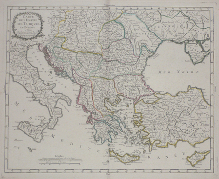
BOURGOIN (Pierre);
Carte de l'empire de Turquie en Europe.
1784 342 x 429 mm.
Referencia librero : LBW02e69
|
|
|
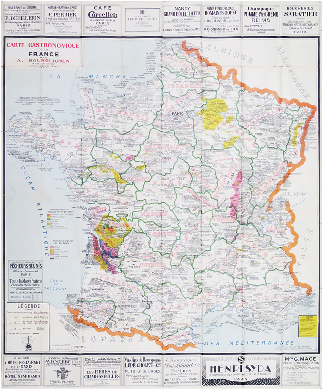
BOURGUIGNON (Alain).
[GASTRONOMIE] Carte gastronomique de la France.
1928. 1,19 x 0,98 m ; repliée.
Referencia librero : LBW-8077
|
|
|
BOURGUIGNON D' ANVILLE, Jean Baptiste (1697 - 1782).
Carte du Royaume d' Aragon. Dressée sur plusieurs Cartes manuscrites et imprimées, sur les Mémoires composés dans le pays par l' Abbé de Vairac (et) sur les Cartes topographiques des Pirenées levées sur les lieux par M. Roussel. 1719. Cartela de encabezamiento con la mención: "Theatre de la Guerre d'Espagne". Reproducción facsímil.
Zaragoza, 1980. 104 x 82 cms. Ejemplar coloreado a mano, a la aguada. Impresión sobre papel fuerte superior.

|
|
|
BOURILLON Florence, CLERGEOT Pierre, VIVIER Nadine
"De l'estime au cadastre en Europe; les systèmes cadastraux au XIXe et XXe siècles."
Paris, Comité pour l'Histoire Economique et Financière de la France, 2008. 16 x 22, 423 pp., quelques cartes, graphiques et illustrations, broché, très bon état.
Referencia librero : 91156 ISBN : 2110953764
|
|
|
Bournis, Theodoritos
I was in the isle of Patmos ...
A short guide to the island of Patmos, particularly the Monastery of St. John the Theologian by the Archimandrite.63p. illus. A small welcome brochure is laid in Book
|
|
|
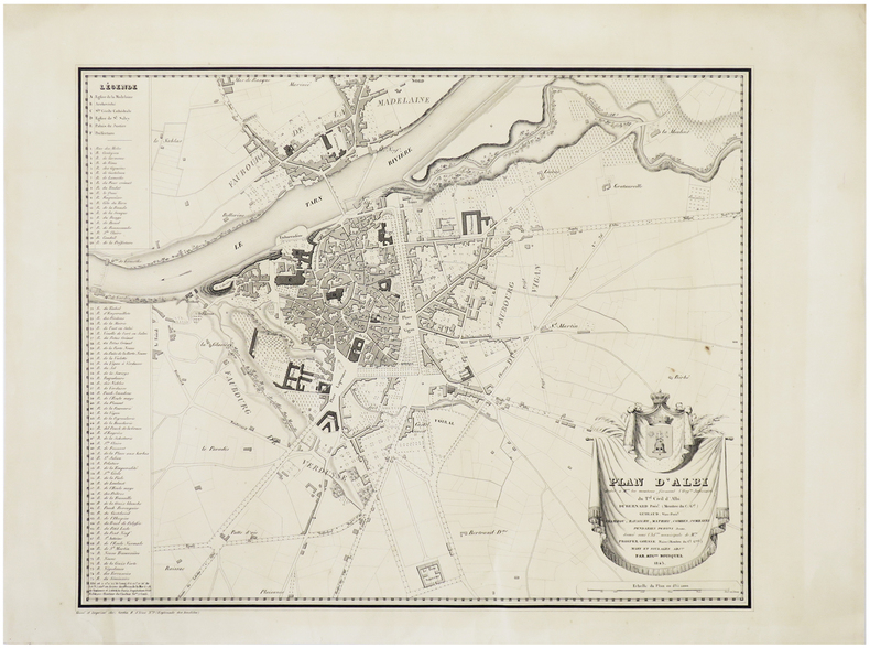
BOUSQUEL (Auguste).
[ALBI] Plan d'Albi.
Paris, Gratia, 1843. 390 x 478 mm.
Referencia librero : LBW-6397
|
|
|
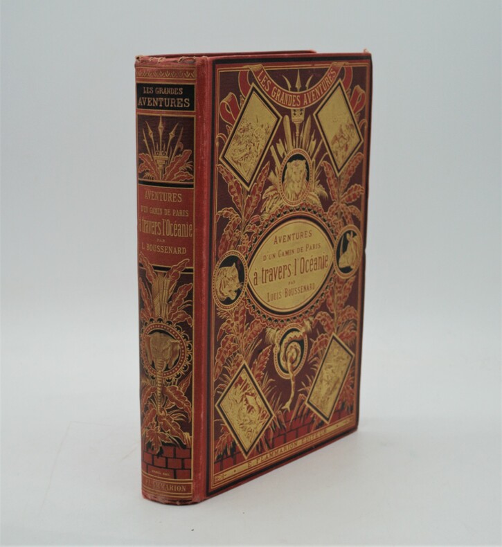
BOUSSENARD (Louis)
Aventures d'un gamin de Paris à travers l'Océanie
Paris, Marpon et Flammarion, sans date (circa 1880). grand in-8, 603 pages. Reliure éditeur pleine percaline rouge au décor richement orné avec plantes et animaux sauvage , dos lisse orné avec auteur , titre, etc. (Engel), tranches dorées , coins légèrement usés ,quelques rousseurs , bel exemplaire.P2-4E
Referencia librero : PHO-1062
|
|
|
BOUTET, Gérard
Les Compagnons du Savoir-Faire, Artisans d’Aujourd’hui
Jean-Cyrille Godefroy, JCG/SELD 1998 In-8, broché couv. illustrée, photographies et croquis en n. & b., 148 pp. Bon état d’occasion.
Referencia librero : 20365
|
|
|
BOUTONNET-TRANIER, Jean-Marc - D'ORPEO, Valtarus
Les quatre songes du bateau mat. Tarots, rouleaux magiques, mythes & symboles.
2022 Editions Dumerchez - 2022 - In-8, broché, couverture à rabats illustrée en couleurs - 75 pages - Nombreuses illustrations en couleurs in-texte
Referencia librero : 119871

|
|
|
Boutwell Clinton Illustrated by Carlson Ken maps charts
Voices of Ancient Civilizations
Leswing Communications 1971. Hardcover. Good. Disclaimer:A copy that has been read but remains in clean condition. All pages are intact and the cover is intact. The spine may show signs of wear. Pages can include limited notes and highlighting and the copy can include previous owner inscriptions. The dust jacket is missing. At ThriftBooks our motto is: Read More Spend Less. Leswing Communications hardcover
Referencia librero : GB000NXQ1MAI3N01

|
|
|
BOUVARD (René) & LAPRÉE (André).
French Line - Linea Francesa. Carte des lignes de la Compagnie Générale Transatlantique.
Paris, Éditions Blondel La Rougery, 1951. 0,73 x 1,09 m.
Referencia librero : LBW-8627

|
|
|
BOUVET Jean
En descendant la Sorgue au début du siècle.
Editions A. Barthélémy, Avignon, 1990.
Referencia librero : 22117
|
|
|
BOUVIER Nicolas; VERNET Thierry:
L'usage du monde.
Paris, Julliard, 1964. In-8 broché de 374-[6]p., couverture à rabats illustrée.
Referencia librero : 20925
|
|
|
BOVARD Pierre-André / BUVELOT Jacques
La côte au bon vieux temps : de Saint-Sulpice à Mies.
Payot, 1975, 176 p., cartonnage éditeur sous jaquette, un ex-libris sur le premier contreplat, l'adhésif de la jaquette se décolle, bon état pour le reste.
Referencia librero : 86441
|
|
|
Bowden Scott/Ward Bill/Skoch George maps
Last Chance for Victory: Robert E. Lee and the Gettysburg Campaign
Cambridge: Da Capo Press 2003. 1st paperback printing. VG. 10 vi 624 p. photos illus maps chapter notes appendices biblio index 8vo; Da Capo Press paperback
Referencia librero : 57223 ISBN : 0306812614 9780306812613

|
|
|
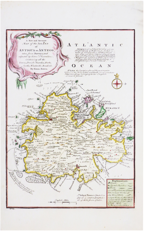
BOWEN (Emanuel).
[ANTIGUA] A new and accurate map of the island of Antigua or Antego.
[Londres, 1747]. 320 x 230 mm.
Referencia librero : LBW-7043
|
|
|
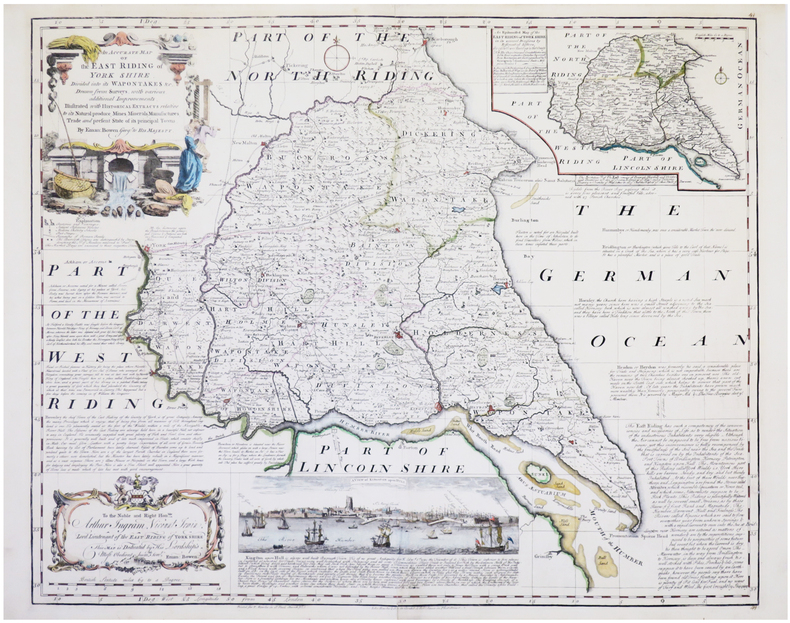
BOWEN (Emanuel).
[YORKSHIRE] An accurate map of the East Riding of York Shire divided into its wapontakes &c.
Londres, John Bowles & Son, & Rob.t Sayer, [circa 1750]. 525 x 652 mm.
Referencia librero : LBW-7675
|
|
|
BOWERY JR. CHARLES R. & RAFUSE ETHAN S. EDITORS; STANLEY STEVEN MAPS
Guide To The Richmond - Petersburg Campaign
University Press of Kansas Lawrence: 2014. Softcover. Brand new book. Lasting from June 1864 through April 1865 the Richmond-Petersburg Campaign was the longest of the Civil War dwarfing even the Atlanta and Vicksburg campaigns in its scope and complexity. This compact yet comprehensive guide allows armchair historian and battlefield visitor alike to follow the campaign's course with a clear view of its multi-faceted strategic operation tactical and human dimensions. A concise single-volume collection of official reports and personal accounts the guide is organized in one-day and multi-day itineraries that take the reader to all the battlefields of the campaign some of which have never before been interpreted and described for the visitor so extensively. Comprehensive campaign and battle maps reflect troop movements historical terrain features and modern roads for ease of understanding and navigation. A uniquely useful resource for the military enthusiast and the battlefield traveler this is the essential guide for anyone hoping to see the historic landscape and the human face of this most decisive campaign of the Civil War. Charles R. Bowery Jr. is an officer in the U.S. Army who has taught Civil War history at West Point led tours of Civil War battlefield sites and authored Lee and Grant: Profiles in Leadership from the Battlefields of Virginia. Ethan S. Rafuse is a professor of military history at the U.S. Army Command and General Staff College. He is the author editor or coeditor of nine books including McClellan's War: The Failure of Moderation in the Struggle for the Union and Robert E. Lee and the Fall of the Confederacy 1863-1865. "A stellar contribution to the long and excellent tradition of the U.S. Army War college guide that covers one of the most important campaigns of the Civil War. The authors' organization and contextualization of their story are superbly done and the maps are outstanding among the best I have ever seen depicting the action and topography of the Richmond Petersburg battle sites."�Earl Hess author of Into the Crater: The Mine Attack at Petersburg "A much needed edition on the final campaign to capture Richmond and Petersburg. This book brings together the events on both sides of the James River enabling readers to understand this very complex and prolonged military event." �Chris Bryce Chief of Interpretation Petersburg National Battlefield "The most thorough detailed and accurate books of their kind. Indeed they are unique. I have used them to lead guided tours of several battlefields with great success." �James M. McPherson author of Battle Cry of Freedom University Press of Kansas, Lawrence: 2014 paperback
Referencia librero : 81930X1
|
|
|
BOWERY JR. CHARLES R. & RAFUSE ETHAN S. EDITORS; STANLEY STEVEN MAPS
Guide To The Richmond - Petersburg Campaign
University Press of Kansas Lawrence: 2014. Hardcover with dustjacket. Brand new book. Lasting from June 1864 through April 1865 the Richmond-Petersburg Campaign was the longest of the Civil War dwarfing even the Atlanta and Vicksburg campaigns in its scope and complexity. This compact yet comprehensive guide allows armchair historian and battlefield visitor alike to follow the campaign's course with a clear view of its multi-faceted strategic operation tactical and human dimensions. A concise single-volume collection of official reports and personal accounts the guide is organized in one-day and multi-day itineraries that take the reader to all the battlefields of the campaign some of which have never before been interpreted and described for the visitor so extensively. Comprehensive campaign and battle maps reflect troop movements historical terrain features and modern roads for ease of understanding and navigation. A uniquely useful resource for the military enthusiast and the battlefield traveler this is the essential guide for anyone hoping to see the historic landscape and the human face of this most decisive campaign of the Civil War. Charles R. Bowery Jr. is an officer in the U.S. Army who has taught Civil War history at West Point led tours of Civil War battlefield sites and authored Lee and Grant: Profiles in Leadership from the Battlefields of Virginia. Ethan S. Rafuse is a professor of military history at the U.S. Army Command and General Staff College. He is the author editor or coeditor of nine books including McClellan's War: The Failure of Moderation in the Struggle for the Union and Robert E. Lee and the Fall of the Confederacy 1863-1865. "A stellar contribution to the long and excellent tradition of the U.S. Army War college guide that covers one of the most important campaigns of the Civil War. The authors' organization and contextualization of their story are superbly done and the maps are outstanding among the best I have ever seen depicting the action and topography of the Richmond Petersburg battle sites."�Earl Hess author of Into the Crater: The Mine Attack at Petersburg "A much needed edition on the final campaign to capture Richmond and Petersburg. This book brings together the events on both sides of the James River enabling readers to understand this very complex and prolonged military event." �Chris Bryce Chief of Interpretation Petersburg National Battlefield "The most thorough detailed and accurate books of their kind. Indeed they are unique. I have used them to lead guided tours of several battlefields with great success." �James M. McPherson author of Battle Cry of Freedom University Press of Kansas, Lawrence: 2014 hardcover
Referencia librero : 81929X1
|
|
|
Bowles, Samuel.
OUR NEW WEST. Records of Travel Between the Mississippi River and the Pacific Ocean. A Full Description of the Pacific Railroad; and of the Life of the Mormons, Indians, and Chinese.
524p. + Plus Engraved Frontis, map and full page plates. Large 8vo. Disbound. ". Over the plains - over the mountains - through the great interior basin-over the Sierra Nevadas-to and up and down the Pacific coast. With details of the wonderful natural scenery, agriculture, mines, busines, social life, progress, and prospects of Colorado, Wyoming, Utah, Idaho, Montana, Nevada, California, Oregon, Washington, and British Columbia; including a full description of the Pacific Railroad; and of the life of the Mormons, Indians, and Chinese." Rader 432; Flake 767; Sabin 7079. AMERICANA BOX 6
|
|
|
Bowsfield Hartwell & Maps
Fort Victoria Letters 1846-1851
Hudson's Bay Record Society. Near Fine in Very Good dust jacket. 1979. Hardcover. Some discoloration and light edgewear to dust jacket. ; 8vo 8" - 9" tall; 376 pp . Hudson's Bay Record Society hardcover
Referencia librero : 36328
|
|
|
BOWYER (Robert).
The Kremlin, Moscow.
1815. 250 x 328 mm.
Referencia librero : LBW-3441

|
|
|
Boyd Andrew Maps By W. H. Bromage
an Atlas of World Affairs
Frederick A. Praeger. Used - Good. Former Library book. Shows some signs of wear and may have some markings on the inside. Frederick A. Praeger unknown
Referencia librero : GRP93418516
|
|
|
Boyd, Andrew
An Atlas of World Affairs
160 pages, maps, index, slight wear to covers, (University Paperbacks ; UP91) eng
|
|
|
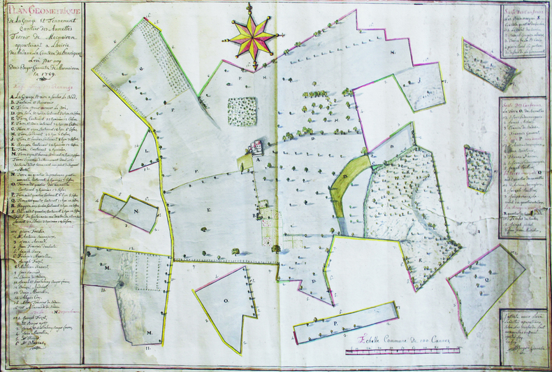
BOYER (Denis).
Plan géométrique de la grange et tennement, quartier des Aumettes, terroir de Mormoiron, appartenant à l'hoirie de Madame la Comtesse des Henriquez. Levé par moy, Denis Boyer, géomètre de Mormoiron, en 1789.
1789. 63 x 94 cm, sur une feuille de 66 x 96,5 cm.
Referencia librero : LBW-6641
|
|
|
Boyle, R.W.
A Decrepitation Study of Quartz from the Campbell and Negus-Rycon Shear Zone Systems, Yellowknife, Northwest Territories
vi, 20 pages with two maps in pocket at back. Geological Survey of Canada Bulletin 30 (Thirty). Bit of writing and two faint stamps on front cover. Average wear. Binding intact. A sound copy. Book

|
|
|
BP
Wales
1 folded map. Good. Scale 4 miles = 1 inch. (BP touring service). 14644. eng
|
|
|
Braby
Braby?s Directories Cover Southern Afrika (Road and Rail Map)
LTD, Brown Davis & Platt, o.J. Faltkarte, einseitig bedruckt mit farbiger Landkarte von Südafrika, Teilstücke von Afrika (Rhodesia, Zambia and Malawi), Statistik-Tabelle und Werbeanzeigen sowie Index, 100x70 cm groß, leichte Einrisse und Kantenbeschabungen, wenige Bleistifteinträge, gebräunt, insgesamt noch ordentlicher Zustand
Referencia librero : 262704ge

|
|
|
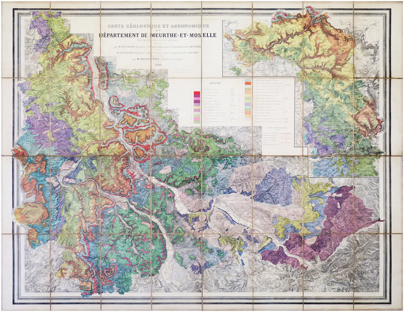
BRACONNIER (Alfred).
[MEURTHE-et-MOSELLE] Carte géologique et agronomique du département de Meurthe-et-Moselle.
1882. En 32 sections montées sur toile et repliées, formant une carte de 1,14 x 1,44 m.
Referencia librero : LBW-7953
|
|
|
Bradley, John
Allied Intervention in Russia
251 pages. Index of names. Bibliography. Maps. "Almost 50 years after the event, the Alliled intervention in Russia following the Bolshevik seizure of power in 1917 remains a conroversial issue. For that reason, and because so much government documentary material has remained inaccessible, it has been badly neglected by professional historians... Provides a wealth of completely new material... The obscure beginnings of the intervention, November 1917 to August 1918, are thoroughly explained, and the role of Japan and Czechoslovakia Corps in the military strategy of the Allies is examined." - from dust jacket. Usual library markings. Above-average wear. Front hinge open. Reading copy only. Book

|
|
|
Bradshaw, Marian Hahn
Canadian Collector Magazine, May/June 1985, Volume 20, No. 3: The Lachine Rapids
100 pages. Features: The Lachine Rapids and their mark on history; Indian trade silver in the McCord Museum collection; Lords of the Lakes - the North West Company 1784-1821; Wintering Dishes - recalling the famed Beaver Club dinners (with recipes!); Trade and Empire - Fishermen began fur trade in New France; The Challenge of Heritage Conservation (in English and French); Several articles in French; Domestic Interiors - Parks Canada's designated houses in Quebec; Exhibit of five centuries of old and rare maps; The Liliane Stewart Collection; Counterfeit Canadiana I; Paperweights. Light wear. Quality copy. Book

|
|
|
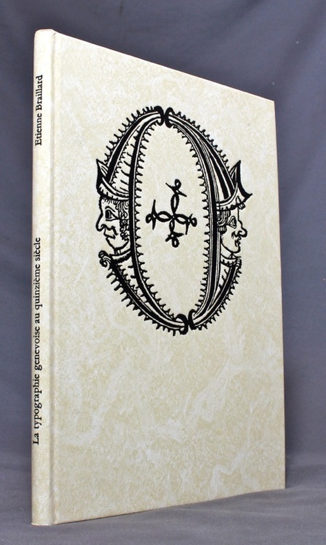
BRAILLARD Etienne; TSCHAN André (préf.):
La typographie genevoise au quinzième siècle.
Genève, Etienne et Christian Braillard, 1978. In-4 de 76-[4] pages, cartonnage ivoire orné d'une grande vignette en noir au premier plat, titre au dos. Impression du texte en noir et rouge.
Referencia librero : 13009
|
|
|
BRAIVE (Georges).
[VENDÉE/ÎLE d'YEU] Île d'Yeu.
Île d'Yeu, G. Penaud, "Nouvelles Galeries Insulaires", 1938. 237 x 349 mm.
Referencia librero : LBW-8221

|
|
|
BRAMBILLA Ambrogio attivo a Roma tra il 1579 ed il 1599
Nova Urbis Romae Descriptio Anni 1587
Rarissima pianta prospettica della città dal Gianicolo, incisa da Ambrogio Brambilla per il tipografo Girolamo Franzini. Si tratta di una piccola pianta, dipendente da quella che il Brambilla stesso incise per Claudio Duchetti nel 1582, aggiornata in parte alla riforma urbanistica di Sisto V. Sono raffigurati gli obelischi di S. Pietro, S. Giovanni e S. M. Maggiore e la via Nova. L’opera è di grandissima rarità; Hülsen (1915) descrive due esemplari nei cataloghi di inizio secolo delle librerie antiquarie romane Rappaport e Lang. Marigliani (2007) riproduce l’esemplare di una collezione privata romana, con una legenda è molto nutrita, addirittura stampata su una lastra separata; è composta da 136 rimandi, dei quali i primi 114 derivano dalla pianta del 1582.In alto, nel riquadro di sinistra, troviamo il titolo e le indicazioni editoriali: NOVA URBIS ROMAE DESCRIPTIO ANNI 1587. Per Ambrosiu s brambilla spictore[m] delineatu s et incisa m. Nel riquadro di destra si legge: Roma fu edifficata gl’anni del mondo 5550 e da poi la destruttione de Troia anni 753 da Romolo, e Remo, fratelli nati da Silvia figliola de Numitore Re de Albano: fu anticame[n]te il suo circuito de le mura miglia 32.Orientazione nei quattro lati al centro con il nome dei punti cardinali: SEPTENTRIO, MERIDIES, OCCIDENS, ORIENS, il nord è a sinistra. Acquaforte e bulino, stampata su carta vergata coeva, con ampi margini, in perfetto stato di conservazione.BibliografiaBifolco - Ronca, Cartografia e Topografia italiana del XVI secolo (2018), pp. 2406-2407, tav. 1238; Ganado (1994): II, n. 116 e III. n. 93; Hülsen (1915): XVIa, p. 63-64, n. 80; Marigliani (2007): n. 60. A very rare map of the city from the Janiculum Hill, engraved by Ambrogio Brambilla for the publisher Girolamo Franzini. It is a small map, based on the one that Brambilla himself engraved for Claudio Duchetti in 1582, partly updated to the urban reform of Sixtus V. The obelisks of S. Pietro, S. Giovanni and S. M. Maggiore and the via Nova are represented. The work is of great rarity; Hülsen (1915) describes two examples in the catalogs of the beginning of the century of the Roman antique bookshops Rappaport and Lang. Marigliani (2007) reproduces the exemple of a private Roman collection, with a very large legend, even printed on a separate plate; it is composed of 136 references, of which the first 114 derive from the map of 1582.Above, in the left box, we find the title and the printing details: NOVA URBIS ROMAE DESCRIPTIO ANNI 1587. For Ambrosiu s brambilla spictore[m] delineatu s et incisa m. Orientation in the four sides with the name of the cardinal points: SEPTENTRIO, MERIDIES, OCCIDENS, ORIENS, the north is on the left. Etching and engraving, printed on contempoary laid paper, with wide margins, in perfect condition.LiteratureBifolco - Ronca, Cartografia e Topografia italiana del XVI secolo (2018), pp. 2406-2407, tav. 1238; Ganado (1994): II, n. 116 e III. n. 93; Hülsen (1915): XVIa, p. 63-64, n. 80; Marigliani (2007): n. 60. Bifolco - Ronca, Cartografia e Topografia italiana del XVI secolo (2018), pp. 2406-2407, tav. 1238.

|
|
|
Brame-Tremblot Geneviève
Chez toi en Normandie
Hachette 1999 22 6x1x14 4cm. 1999. Broché.
Referencia librero : 500110242

|
|
|
Branch, Melville C.
An Atlas of Rare City Maps: Comparative Urban Design, 1830-1842
This is a very good hardcover copy in a very good dust jacket. The jacket is a little toned and has a bit of light soil. Internally completely clean. Maps of 40 cities in Europe, Russia, America and Asia are presented in full-page color plates. All maps were drawn and published between 1830 - 42. 13" high X 15" wide, 102 pages. Large heavy book. Foreign shipping will be extra. This book will be securely wrapped and packed in a sturdy box and sent with tracking.
|
|
|
Brandao Adriana
Aujourd'hui le Bresil
Casterman 2014 144 pages 20 2x25 1x1 1cm. 2014. Relié. 144 pages.
Referencia librero : 500058969

|
|
|
Brandao Adriana
Aujourd'hui le Bresil
Casterman 2014 144 pages 20 2x25 1x1 1cm. 2014. Relié. 144 pages.
Referencia librero : 500078500

|
|
|
Brandao Adriana
Aujourd'hui le Bresil
Casterman 2014 144 pages 20 2x25 1x1 1cm. 2014. Relié. 144 pages.
Referencia librero : 500078508

|
|
|
Brandao Adriana
Aujourd'hui le Bresil
Casterman 2014 144 pages 20 2x25 1x1 1cm. 2014. Relié. 144 pages.
Referencia librero : 500093062

|
|
|
Brandao Adriana
Aujourd'hui le Bresil
Casterman 2014 144 pages 20 2x25 1x1 1cm. 2014. Relié. 144 pages.
Referencia librero : 500095025

|
|
|
Brandao Adriana
Aujourd'hui le Bresil
Casterman 2014 144 pages 20 2x25 1x1 1cm. 2014. Relié. 144 pages.
Referencia librero : 500121600

|
|
|
Brandlmayr, John; et al
Northwest Sportsman Magazine - Fishing, Hunting and Boating in B.C., May 1961 - Revised Fresh Water Fishing Spots and Maps of British Columbia
42 pages. Features: Revised Fresh Water Fishing Spots and Maps of British Columbia; Nice one-page illustrated ad for Gibbs fishing tackle; One-page illustrated ad for Hardy and Milward split cane fishing rods from England; Marine fir plywood ad; Clay Chips - article with photos of Mr. & Mrs. Bert Whelan, Ray Gray, Virgil Poppe, Rudy Wiley, Earl Caldwell, Don McKay, Paul Maylor, Larry French, C.H. Reinhard, and Verne Greensword; Yacht Bureau begins research and product testing program; Boats; Nice framable one-page ad inside back cover by the B.C. Department of Recreation and Conservation entitled "Good Fishing!"; Nice photo-illustrated Lucky Lager ad on back cover; Many additional nostalgic ads. Unmarked with moderate wear. A quality vintage copy. Book

|
|
|
Brasnett Hugh / with Photographs By the Author and Maps By Jenny Brasnett
Thomas Hardy : A Pictorial Guide A Travel Guide with Maps of Thomas Hardy's England Countryside Perhaps What Inspired Him to Write of English life
~ SCARCE TITLE ~: Lodge Copse Press 1990 1990. Paperback : soft cover edition in good or better condition some slight wear to edges as normal for age of book. Overall good copy of this title. Excellent read. A good book to enjoy and keep on hand. Or would make a great gift for the fan / reader in your life. Clean and Unmarked Text. Illus. by Fully Illustrated. Biography / Great Places to See and Explore. Travel Culture History. Lodge Copse Press 1990 paperback
Referencia librero : 5024231 ISBN : 0951560905 9780951560907

|
|
|
Brass, R.A.
White Rock (British Columbia) By the Sea: Town Map
24" x 18" map of White Rock, British Columbia. Undated but appears to be circa 1978. Includes directory and locations of local businesses. Light wear. Unmarked. A quality copy of this nice White Rock memento. Map

|
|
|
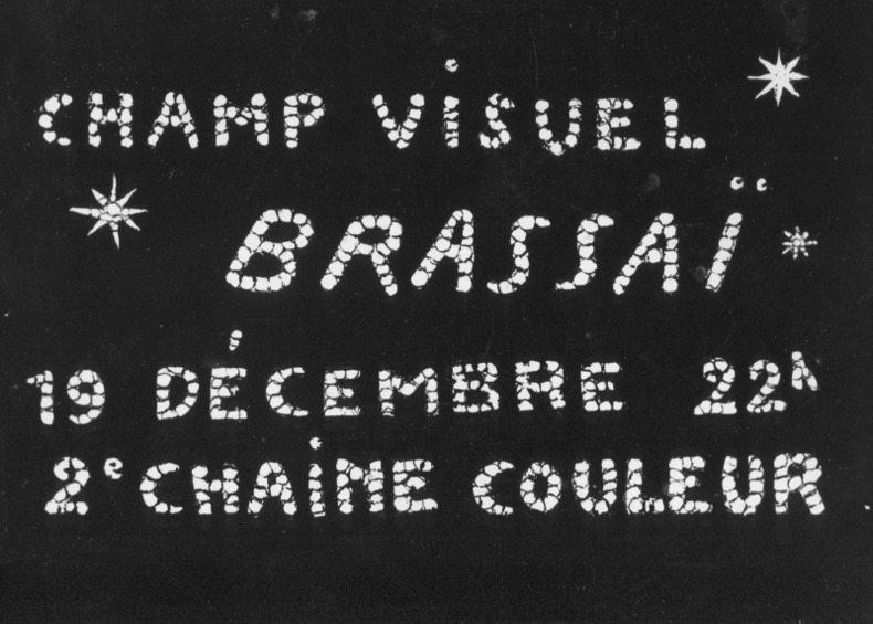
BRASSAI.
Photo-carte avec la signature autographe de Brassaï au verso (années 1970).
Carte postale (10,5 x 15 cm), années 70. Annonce du documentaire télévisé "Champ visuel Brassaï - 19 décembre 22 h - 2e chaîne couleur". Signé au dos par le photographe.
Referencia librero : 68129
|
|
|
BRASSAI.
Photo-carte avec la signature autographe de Brassaï au verso (années 1970).
Carte postale (10,5 x 15 cm), années 70. Annonce du documentaire télévisé "Champ visuel Brassaï - 19 décembre 22 h - 2e chaîne couleur". Signé au dos par le photographe.
Referencia librero : 68129
|
|
 Recibir por correo electrónico
 Descargar en documento PDF
 Flujo RSS


