|
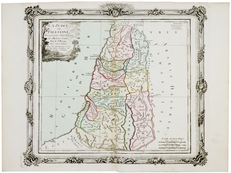
BRION de la TOUR (Louis).
La Judée ou Palestine.
Paris, Desnos, [circa 1760]. 280 x 312 mm.
Referência livreiro : LBW-5177
|
|
|
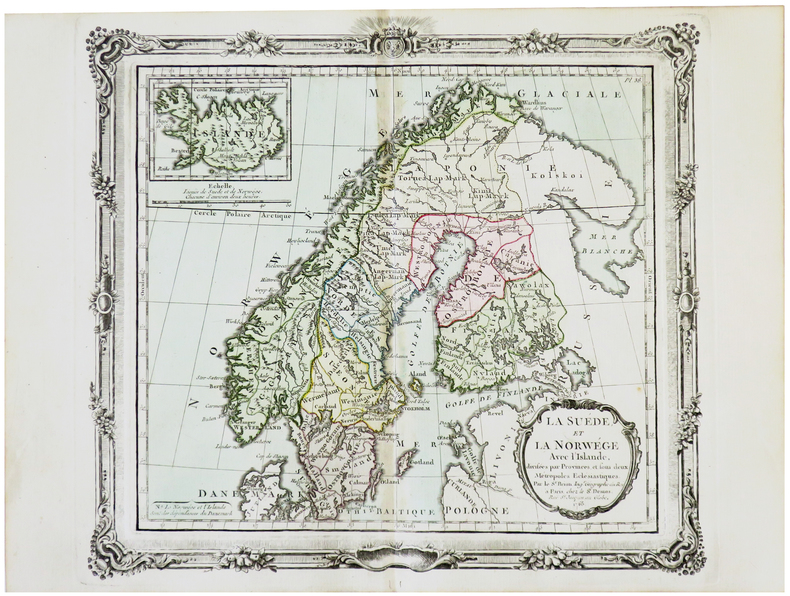
BRION de la TOUR (Louis).
La Suède et la Norwège avec l'Islande.
Paris, Desnos, 1766 [1772]. 275 x 307 mm.
Referência livreiro : LBW-5703
|
|
|
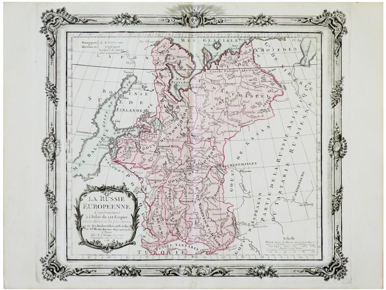
BRION de la TOUR (Louis).
La Russie européenne.
Paris, Desnos, 1766 [1772]. 279 x 313 mm.
Referência livreiro : LBW-5672
|
|
|
BRION de la TOUR (Louis).
Le Danemark divisé par provinces et diocèses.
Paris, Desnos, 1766 [1772]. 280 x 315 mm.
Referência livreiro : LBW-5686

|
|
|
BRIAND Pierre-César:
Les jeunes voyageurs en Europe, ou description raisonnée des divers pays compris dans cette partie du monde.
Paris, Lelong, 1823. 5 volumes in-12 de [4]-IV-251; [4]-231; [4]-239; [4]-255-[1]; 292 pages, demi-veau glacé rouge, dos lisse orné de filets et fleurons dorés.
Referência livreiro : 19071
|
|
|
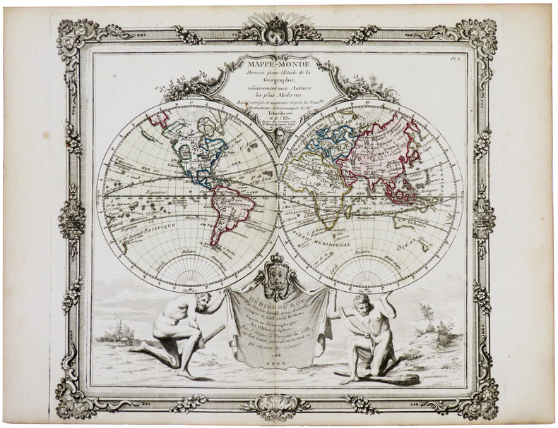
BRION de la TOUR (Louis).
Mappe-monde dressée pour l'étude de la géographie, relativement aux auteurs les plus modernes.
Paris, Desnos, 1766. 284 x 307 mm.
Referência livreiro : LBW-5767
|
|
|
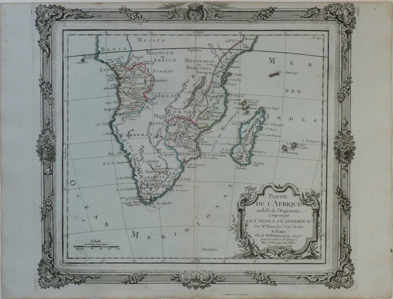
BRION de la TOUR (Louis).
Partie de l'Afrique audelà de l'équateur, comprenant le Congo, la Cafrérie &c.
Paris, Sr. Desnos, 1766 [1772]. 280 x 310 mm.
Referência livreiro : LBW-1186
|
|
|
BRION de la TOUR (Louis).
Partie de l'Afrique au delà de l'équateur, comprenant le Congo, la Cafrérie &c.
Paris, Desnos, 1766 [1772]. 275 x 307 mm.
Referência livreiro : LBW-5639

|
|
|
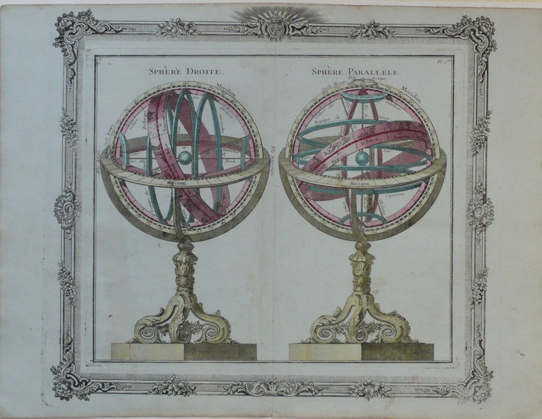
BRION de la TOUR (Louis);
Sphère droite - Sphère parallèle.
Paris Desnos 1772 280 x 310 mm.
Referência livreiro : LBW-1245
|
|
|
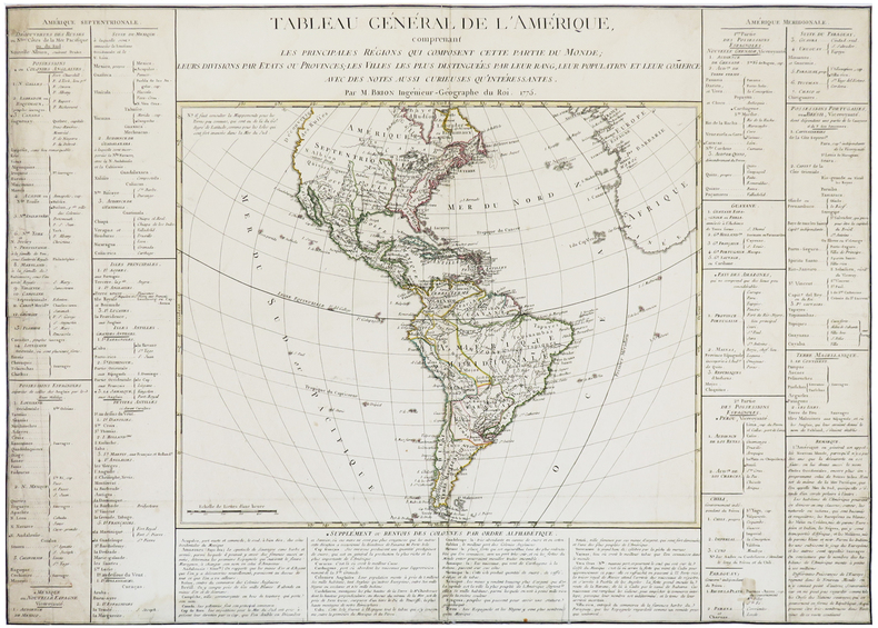
BRION de la TOUR (Louis).
Tableau général de l'Amérique, comprenant les principales régions qui composent cette partie du monde ; leurs divisions par états ou provinces ; les villes les plus distinguées par leur rang, leur population et leur comerce : avec des notes aussi curieuses qu'intéressantes.
1775. 520 x 730 mm.
Referência livreiro : LBW-5870
|
|
|
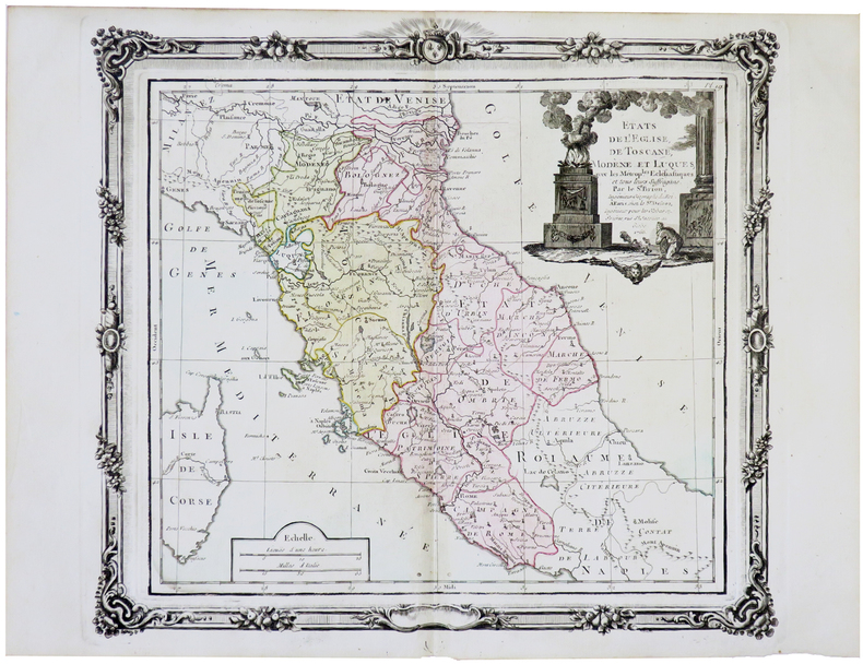
BRION de la TOUR (Louis).
États de l'Église, de Toscane, Modène et Luques.
Paris, Desnos, 1766 [1772]. 280 x 308 mm.
Referência livreiro : LBW-5658
|
|
|
BRIAN LE MESSURIER SKETCH MAPS BY F. RODNEY FRASER
Le Messurier Brian : Ggw:Dartmoor33 Warne walking guides
Frederick Warne Publishers Ltd 05/28/1987. Paperback. Used; Good. WE SHIP WITHIN 24 HRS FROM LONDON UK 98% OF OUR ORDERS ARE RECEIVED WITHIN 7-10 DAYS. We believe you will be completely satisfied with our quick and reliable service. All orders are dispatched as swiftly as possible! Buy with confidence! Frederick Warne Publishers Ltd paperback
Referência livreiro : 3658718 ISBN : 0723234396 9780723234395
|
|
|
Brian Roberts & Richard Schwadel Illustrated Maps in Red B/W. Paperback with Wild Looking Guy Driving on Cvr with Wild Brown
L.A. Shortcuts: A Guidebook for Drivers Who Hate to Wait Paperback with Wild Looking Guy Driving on Cvr with Wild Brown Eyes Drawn By Perry Van Schelt. Includes Beverly Hills Shortcuts Canyon Shortcuts Downtown Shortcuts Hollywood & Valley Shortc
Red Car Press Los Angeles 1989. Blue SOFTCOVER PBO 1989 Stated 1st Edition 3rd Printing NF/VG SOFTCOVER 7 1/2 X 9 in. Cover light rub wear & tiny chips Edges.213 pgs interior nice tight cleanlight wear. First Edition. Soft Cover. Red Car Press Los Angeles paperback
Referência livreiro : 25854 ISBN : 0926055003 9780926055001

|
|
|
Bricker Charles Text and Tooley R. V.Maps
LANDMARKS OF MAPMAKING AN ILLUSTRATED SURVEY OF MAPS AND MAPMAKERS
Elsevier 1968. Hardcover. Good/Good. Hardcover: Linen bound boards with design in gold on lower front board. Title on spine in gold with white/gold printed bands. Top spine edge is frayed through down to board. Corners are lightly bumped. Nice illustrated endpapers. Absolutely fascinating text with gorgeous Fold-out antique map reproductions. Nice tight binding. Color map illustrated dust jacket has edgewear and chipping to corners spine ends and all edges. Lamination is gone from sections of the jacket. Foxed with some soil. Closed tears rubbing. In protective mylar. Elsevier hardcover
Referência livreiro : INVENT011918I
|
|
|
BRIGHTON.
Plan of Brighton [with comprehensive Street Index]. W. H. Smith's Series of Reduced Ordnance Survey Maps for Tourists by J. Bartholomew. [Scale: 2.5 inches to One Mile.] FINE COPY AND A RARE SURVIVAL
8vo., folding coloured map on cloth measuring 17 x 23 inches (approx. 43 x 59 cms) folding in 18 panels to 6.5 x 4.25 inches (approx. 17 x 11 cms); original limp cloth wrappers printed in red and black, radial corners, a near fine copy. Includes comprehensive street index keyed to map. EXTREMELY SCARCE IN THIS CONDITION.
|
|
|
Brill, Edith
Portrait of the Cotswolds
No marks or inscriptions. A very clean very tight copy with bright unmarked boards, slight foxing to top of page edges and no bumping to corners. Dust jacket price clipped but not marked or creased with small nicks to upper edge and a chip to lower edge. 192pp. Same year reprint of the first edition of Edith Brill's excellent study of the Cotswolds.

|
|
|
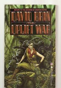
Brin David cover art by Michael Whelan maps by Jaye Zimet
THE UPLIFT WAR
New York: Bantam Books Spectra 1987. Very Good. 1987. First Edition. Mass Market Paperback. 055325121X . First trade edition. Hugo Award winning sequel to STARTIDE RISING. 638 pages. VG copy slight spine cocking cheap text paper starting to tan. . Bantam Books [Spectra] [1987] paperback
Referência livreiro : 40527 ISBN : 055325121X 9780553251210
|
|
|
Brion, de la Tour, L
Cercles de Bavière, de Franconie et de Souabe: divisés en toute leur Principautés et provinces. Altkolorierter Kupferstich mit Flächenkolorit.
Paris, Desnos, 1765. Blattgröße 26 x 34 cm. Bildgröße 23,3 x 26 cm.
Referência livreiro : 28250

|
|
|
Briscoe John D'Auby; Sharp Robert Lathrop & Borish Murray Eugene & Maps
A Mapbook of English Literature
Henry Holt & Co. Good with no dust jacket. 1936. Hardcover. Front cover stained; name whited-out on front pastedown ; 8-1/4" x 11-1/4"; 47 pages . Henry Holt & Co hardcover
Referência livreiro : 309794
|
|
|
BRITISH AMERICAN PLANTATIONS / NORTHWEST COAST MAPS Urban Sylvanus David Henry Editor. Emanuel Bowen cartographer; William Hogar
Gentleman's Magazine and Historical Register.January to December 1754. With maps: "British American Plantations" by Bowen and "Discoveries of Admiral de Fontes."
London.: D. Henry and R. Cave at St. John's Gate. Volume XXIV. 1754. Bound volume 3/4 leather binding spine perished covers detached and very worn; 8 3/4 x 5 1/4 inches; title page and preface; 603 pp and index. Bookplate on verso of front cover of Richard Pulteney MD the English physician who advanced acceptance of Linnaean taxonomy and the author of the first English language biography of the botanist. It appears the volume subsequently became the property of the Exeter City Library as is affirmed by the presence of several circular ink stamps on various pages. Volume notable for two uncolored maps "British American Plantations" by Bowen and "Discoveries of Admiral de Fontes." One plate Bridge at Blois suffers a clean tear along one fold. With regard to the plates the volume has been eccentrically bound. Several plates are not present others are bound not according to the publisher's instructions while there are present plates from other sources. These plates are of eminent men of the time and are inserted at intervals throughout the volume. Overall contents in good condition with plates bright and clean--although somewhat of a grab bag in terms of their organization plus the unlisted presence of additional subject matter. Present is a bright and clean copy of Bowen's "Map of the British American Plantations.from Boston.to Georgia." 9 x 11 1/2 inches. This highly detailed map identifies the Plantations along the east coast and also English and French forts the topography of the region and established trails leading inland to the Mississippi. It is particularly noteworthy for the delineation of Indian tribes to the west of the Blue Ridge Mountains; indeed it is a preeminent map in this regard. Also present is M. De l'Isle's "A General Map of the Discoveries of Admiral De Fonte & Others" 8 x 10.75 inches depicting discoveries in the North Pacific with attention to the supposed Northwest Passage. The map has been described as "a spectacular example of imagination and fiction on the one hand and up-to-date cartography and information on the other" — this latter based on De l'Isle's access in St. Petersburg to secret maps of Russian discoveries as well as personal experiences on a voyage of Russian exploration source: Wendt Collection website. There are six or more engraved portraits of eminent men not called for in the volume's list of plates. These are: Hogarth's James Gibbs the noted architect; Hogarth's Martin Folkes President of the Royal Society; Captain Isaac Schomberg famed for his exploits in the American Revolutionary War; Alexander Cruden eccentric Biblical scholar; Richard Mead physician; and William Dampier explorer and natural historian of New Holland. Also present in the volume is an account of George Washington's "Journey from Williamsburg to the French Fort near the Lake Erri in Virginia." The object of Washington's travels was to dissuade Native Americans from all dealings with the French. A fascinating volume warranting the renewal of covers and spine. Contents in overall good condition with occasional soiling and offset. . D. Henry and R. Cave at St. John's Gate. hardcover
Referência livreiro : 50809

|
|
|
British Columbia (B.C.) Ferries
British Columbia (B.C.) Ferries - 1968 Route Map
9" x 4" - folds out to 24" x 18". Colour map on one side shows B.C. Ferry routes. Reverse side provides details of tourist destinations with colour photos, reservation details for the sailing to Prince Rupert, corporate contact details, and a brief statement by W.A.C. Bennett. Unmarked with moderate wear. A sound copy. Book

|
|
|
British Columbia Government Travel Bureau
British Columbia Road Map 1962-1963 - With Campsite and Fishing Guide
Traditional road map measuring 20" x 40" when unfolded. One side provides a colour map of the province. The back side provides very detailed information about campsites around the province and extensive information about B.C.'s native fish as well as hunting and fishing regulations, including fees. Unmarked with moderate wear. A sound vintage copy. Map

|
|
|
British Columbia Government Travel Bureau
British Columbia Road Map 1964-1965 - With Campsite and Fishing Guide
Traditional road map measuring 20" x 40" when unfolded. One side provides colour maps of the province. The back side provides very detailed information about campsites around the province and extensive information about B.C.'s native fish as well as hunting and fishing regulations, including fees. Unmarked with moderate wear. A sound vintage copy. Map

|
|
|
British Columbia Travel Bureau
British Columbia 1959 Road Map/Travel Guide with Campsite Locations
Traditional road map measuring 31" x 24" when unfolded. Provides excellent colour map coverage of the Province as well as detailed, and now historic, information about campsites in regions around the province. Moderate wear. Four-inch opening along a fold. A quality vintage copy. Map

|
|
|
British War Office
Lille-Ghent British Military Map - Second Edition, June 1944 - Sheet No. 2
34.5" x 25" paper map. Identifies Roads, Railways, International Boundaries, Churches, Forts, Lighthouses, Woodlands. Average wear. Book

|
|
|
British War Office
World War II British Military Map of Le Havre, France N.W. 48/2
34.5" x 26.5" reinforced paper. N.W. 48/2. Geographical Section, General Staff, No. 4072. Compiled and drawn at War Office, 1940. Heliographed and printed at Ordnance Survey, 1940. Identifies Land Aerodromes, Landing Grounds, Water Aerodromes, Radioelectric Stations, Explosives Areas, and more. Average wear and soiling. Name in ink in upper right corner. Name in pencil along top edge. Cover not included. Book
|
|
|
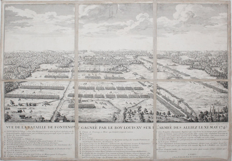
BROÜARD.
[BELGIQUE] Vue de la bataille de Fontenoy gagnée par le roy Louis XV sur l'armée des alliez le XI may 1745.
Paris, Limosin, [circa 1750]. En 6 sections montées sur toile et pliées, formant une carte de 349 x 497 mm.
Referência livreiro : LBW-3212
|
|
|
Brodrick, Alan Houghton (editor)
Normandy : The People's France
No marks or inscriptions. A very clean very tight copy with bright unmarked boards, very slight foxing to page edges and no bumping to corners. Dust jacket not price clipped or marked owith small tear/crease near upper front spine edge. Large fold-out map at rear in excellent condition. 316pp. Well illustrated study and guide for the area of Normandy in northern France. The same format as Mee's King's England.

|
|
|
Bronislaw Malinowski; Illustrator Illustrated by B/w Photos and Maps
Argonauts of the Western Pacific: An Account of Native Enterprise and Adventure in the Archipelagoes of Melanesian New Guinea by Bronislaw Malinowski; Illustrator-Illustrated by B/w Photos and Maps
E. P. Dutton & Co. January 1961. Paperback. Good - Cash. General use wear surface and edges rubbed with some creasing. Corners bumped and show wear. Pages show reader wear. Unmarked pages. Stock photos may not look exactly like the book. E. P. Dutton & Co. paperback
Referência livreiro : 728018
|
|
|
Browicz, Kazimierz
Chorology of Trees and Shrubs in South-West Asia and Adjacent Regions. Maps. Vol. 8 part 1 [and part two]. 2 Bände.
Kórnik [near Poznan], [Eigenverlag], 1989. Qu.-Fol. Mit zus. 51 Karten. OKart-Bde. m. Deckelschild.
Referência livreiro : 57703

|
|
|
Browicz, Kazimierz u. Jerzy Zielinski
Chorology of Trees and Shrubs in South-West Asia and Adjacent Regions. Volume one [1]. Maps.
Kórnik near Poznan, [Eigenverlag], 1978. Qu.-Fol. Mit 100 Karten. OKart. m. mont. Orig.-Fotografie am Vorderdeckel.
Referência livreiro : 57704

|
|
|
Browicz, Kazimierz u. Jerzy Zielinski
Chorology of Trees and Shrubs in South-West Asia and Adjacent Regions. Volume seven [7]. Maps.
Kórnik near Poznan, [Eigenverlag], 1988. Qu.-Fol. Mit 50 Karten. OKart. m. Deckelschild.
Referência livreiro : 57702

|
|
|
Brown MSc DipCOT SROT Gillian Editor; Esdaile PhD MAPS OTR Susan Editor; Ryan Susan Editor;
Becoming an Advanced Healthcare Practitioner 1e
Butterworth-Heinemann 2003-04-30. Paperback. Very Good. Ex-library paperback in very nice condition with the usual markings and attachments. Text block clean and unmarked. Tight binding. Butterworth-Heinemann paperback
Referência livreiro : OCCC082 ISBN : 0750654414 9780750654418

|
|
|
Brown, June
Karen Brown's Ireland : Charming Inns & Itineraries
No marks or inscriptions. No creasing to covers or to spine. A very clean very tight copy with bright unmarked boards, slight traces of storage and no bumping to corners. 243pp. Travel/accommodation guide to Ireland.

|
|
|
Brown, Ruth and Nigel Owens
York : the Picture Map and Guide
1st edition. Very good condition folded picture map and guide. ISBN 0951886908 50969. eng
|
|
|
Browne, Lewis.
STRANGER THAN FICTION. A Short History of the Jews from Earliest Times to the Present Day. With Fifty Animated Maps by the Author, Giving a Pictorial History of Centuries of Wandering.
377 p. AUTOGRAPHED BY THE AUTHOR. Illustrated with numerous maps. John J. Bataille's copy with his notes. 12mo. Original full red cloth binding, gold lettered with pictorial scene embossed in black on front board. Extremities slightly worn. Hardbound. First Edition of a famous classic. JUDAICA BOX 5
|
|
|
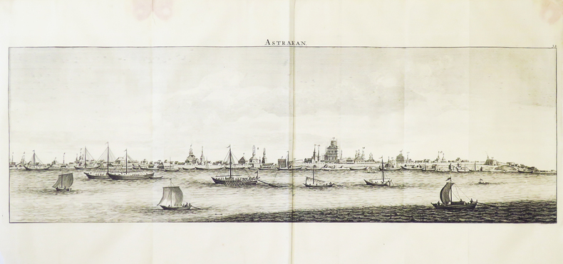
BRUYN (Cornelis de, dit Corneille Le Brun).
[ASTRAKHAN] Astrakan.
[Amsterdam, 1718]. 204 x 620 mm.
Referência livreiro : LBW-4898
|
|
|
BRUNIÈRE (Fernand de la) & PONCE (Nicolas).
[HAÏTI] Vue du Cap François, isle St. Domingue, prise du chemin de l'embarcadère de la Petite Anse.
Paris, M. Moreau de St. Méry et M. Ponce, [1791]. 283 x 587 mm.
Referência livreiro : LBW-5136

|
|
|
BRUYN (Cornelis de, dit Corneille Le Brun).
[IRAN] Spahan.
[Amsterdam, 1718]. 29,4 x 159 cm.
Referência livreiro : LBW-4891

|
|
|
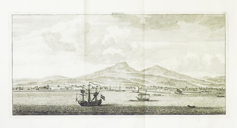
BRUYN (Cornelis de, dit Corneille Le Brun).
[JAKARTA/JAVA] Batavie.
[Amsterdam, 1718]. 169 x 355 mm.
Referência livreiro : LBW-4899
|
|
|
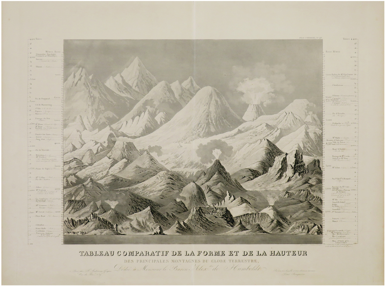
BRUGUIÈRE (Louis).
[MONTAGNES du MONDE] Tableau comparatif de la forme et de la hauteur des principales montagnes du globe terrestre, dédié à Monsieur le Baron Alex.dre de Humboldt.
Paris, J. Andriveau-Goujon, [circa 1845]. 408 x 558 mm.
Referência livreiro : LBW-7411
|
|
|
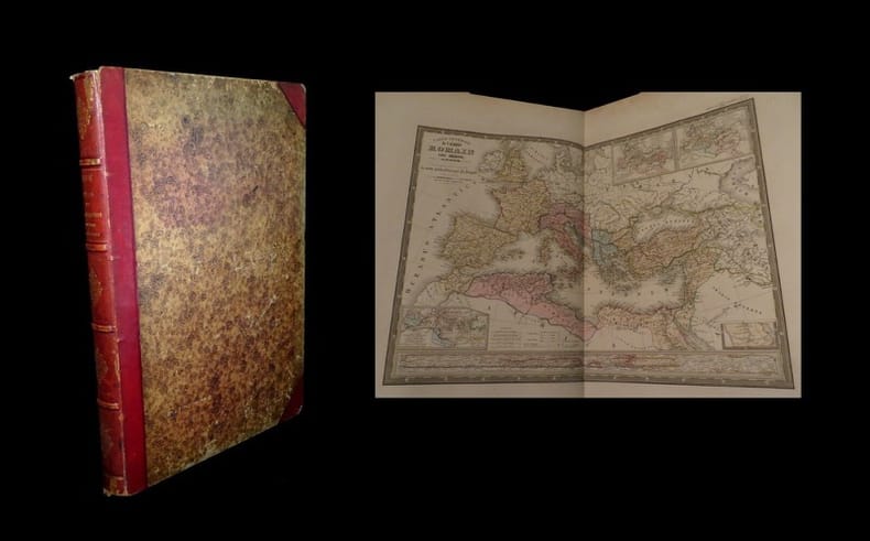
BRUE (Adrien Hubert) & PICQUET (Charles).
Atlas universel de Géographie physique, politique, ancienne et moderne contenant les cartes générales et particulières de toutes les parties du monde pour servir à l'intelligence de l'Histoire, de la Géographie, et des voyages.
Paris, chez Bartheleimer, 1857. Un fort vol. au format in-plano (543 x 397 mm) de 1 f. bl., 3 ff. n.fol., 65 planches et 1 f. bl. Reliure de l'époque de demi-chagrin maroquiné cerise à coins, filets gras et maigres à froid portés sur les plats, dos à nerfs orné de filets gras et maigres à froid, filets en pointillés dorés, quadruples filets dorés sur les nerfs, larges fleurons romantiques dorés, titre doré.
Referência livreiro : 17047
|
|
|
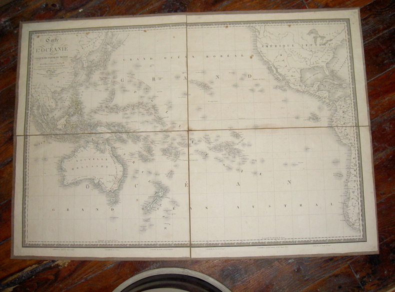
Brué (A.)
Carte de l'Océanie
Carte de l'Océanie ou cinquième partie du Monde, par A. Brue, Géographe du Roi. Publiée pour la première fois en 1822 par J. Goujon. Revue et augmentée par l'éditeur d'après de nouveaux matériaux. A Paris chez J. Goujon et J. Andriveau, géographes éditeurs, rue du Bac N°6 près le Pont-Royal 1827. Carte entoilée (quatre parties en une feuille de 92X63 cm)
Referência livreiro : ARC-223
|
|
|
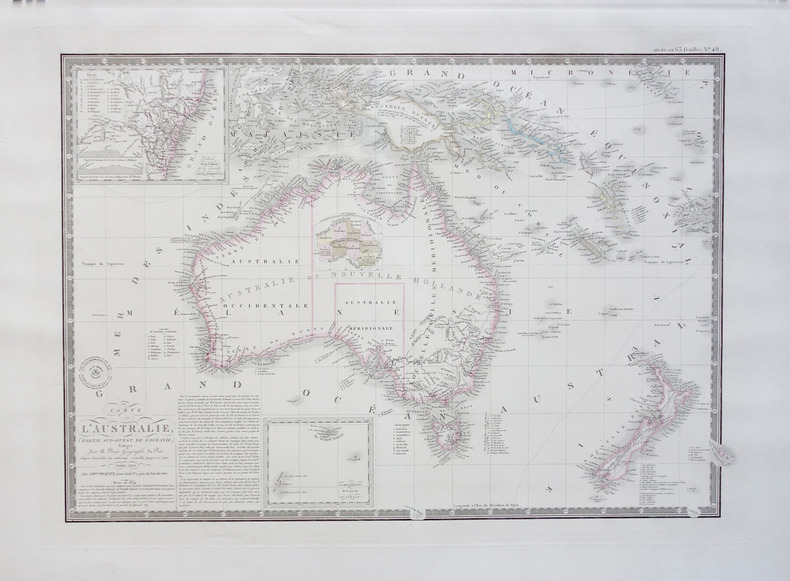
BRUE (Adrien Hubert);
Carte de l'Australie (partie sud-ouest de l'Océanie).
Paris Ch.les Picquet 1834 366 x 530 mm.
Referência livreiro : LBW-1796
|
|
|
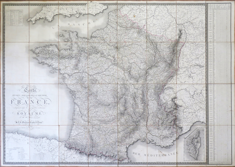
BRUE (Adrien Hubert).
Carte physique, administrative et routière de la France, indiquant aussi la navigation intérieure du royaume.
Paris, J. Goujon, 1818. En 32 sections montées sur toile et pliées, formant une carte de 1,13 x 1,58 m, étiquette de l'éditeur Auvray au dos de la carte.
Referência livreiro : LBW-4324
|
|
|
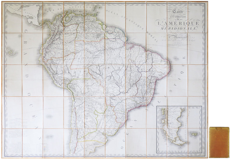
BRUÉ (Adrien Hubert).
Carte encyprotype de l'Amérique méridionale.
Paris, Desray & Goujon, 1816. En 50 sections montées sur toile et repliées, formant une carte de 1,12 x 1,38 m ; sous chemise et étui de papier de l'époque, avec titre en lettres dorées au dos, et dentelle dorée encadrant les plats.
Referência livreiro : LBW-8596
|
|
|
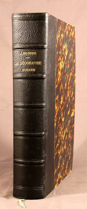
BRUNHES Jean:
La géographie humaine. Essai de classification positive. Principes et exemples.
Paris, Félix Alcan, 1910. In-4 de [4]-IV-843p. demi-maroquin noir, dos à faux nerfs. Belle, simple et solide reliure.
Referência livreiro : 2779
|
|
|
BRUE (Adrien Hubert);
Nouvelle carte des Etats-Unis, des haut et bas-Canada, de la Nouv.le-Ecosse, du Nouv.au Brunswick, de Terre-Neuve &a.
Paris Ch. Picquet 1843 635 x 928 mm.
Referência livreiro : LBW-1705

|
|
|
BRUN Giovanni (Roma 1745 - 1800)
Urbis Ichnographiam A Leonardo Bufalino
Urbis Ichnographiam A Leonardo Bufalino Ligneis formis Evulgatam Servata Proportione contractam Atq. Aeri incsam Jo. Bapta. Nolli. . Pianta geometrica con elevazione, pubblicata a Roma dalla tipografia di Carlo Losi nel 1785. Si tratta di una rielaborazione, senza alcun aggiornamento, dell'importante rilievo di Leonardo Bufalini (1551), riportato in voga da Giovan Battista Nolli nel 1748. La legenda di 307 rimandi in latino è ripesa proprio dalla riduzione di Nolli, e ne dimostra la diretta derivazione. T "La pianta di Roma di Leonardo Bufalini è la prima rappresentazione coerente della città e la più importante raffigurazione ortogonale fino alla pianta grande di Giambattista Nolli (1748). Bufalini si occupò di tutte le fasi della sua realizzazione, dal rilievo all’incisione, impiegando un lungo tempo: sette anni, secondo Onofrio Panvinio, venti secondo l’editore Antonio Trevisi. La Pianta di Roma fu stampata presso il tipografo Antonio Blado il 26 maggio 1551 a Roma, con privilegio decennale della Repubblica di Venezia e la dedica a Carlo V e a papa Giulio III. Si tratta di un’opera monumentale: una xilografia in dodici fogli e quattro strisce laterali. Nessun esemplare della prima edizione è noto; se ne conoscono solo tre della seconda edizione, pubblicata sempre a Roma, dall’editore Antonio Trevisi da Lecce, due conservati alla Biblioteca Vaticana (di cui uno incompleto) e un terzo alla British Library di Londra. Sebbene la pianta sia basata su rilievi effettuati dall’autore con grande perizia, non mancano elementi di fantasia: molti monumenti antichi sono stati aggiunti, completati e ricostruiti liberamente. Del resto, è lo stesso autore a sottolineare questa ambivalenza, dichiarando di voler presentare “la città che oggi è abitata…aggiungendo la [città] antica, un tempo sovrana del mondo…” Bufalini incluse nella pianta anche un autoritratto in cui è raffigurato con in mano il compasso a due punte, mentre a sinistra sono rappresentati i suoi strumenti di lavoro, fra cui la squadra e la bussola nautica. Per una più completa trattazione degli strumenti di misurazione utilizzati e per l’accuratezza della pianta bufaliniana si rimanda ai numerosi studi pubblicati. La fonte primaria utilizzata da Bufalini è la Roma antica di Bartolomeo Marliano, inserita nella sua Urbis Romae Topographia, che ha lo stesso orientamento e la stessa precisione nei particolari. Fin dalla sua pubblicazione nel 1551, la pianta del Bufalini esercitò una notevole influenza sulle successive piante della città fino al 1748, anno in cui Giambattista Nolli ne pubblicò una copia ridotta insieme alla sua pianta grande, che si impose quale nuovo modello" (cfr. B/R p. 2372). Nel margine inferiore, la sottoscrizione dell'editore C. Losi e, nell'angolo opposto, quella dell'incisore Giovanni Brun. In basso, a sinistra, il Pantheon e il Foro di Nerva; a destra, l'arco di Giano quadrifronte. Acquaforte e bulino, impressi su carta vergata coeva, applicata su tela, più volte ripiegata. Astuccio di custodia originale, in cartonato. In ottimo stato di conservazione. Geometric plan with elevation, published in Rome by Carlo Losi in 1785 and engraved by Giovanni Brun. It is a reworking, without any updating, of the important relief by Leonardo Bufalini (1551), brought back by Giovan Battista Nolli in 1748. The key-legend of 307 references in Latin is taken from Nolli's reduction, and demonstrates its direct derivation. Leonardo Bufalini's map of Rome is the first coherent representation of the city and the most important orthogonal representation up to the large plan by Giambattista Nolli (1748). Bufalini took care of all the phases of its realization, from relief to engraving, using a long time: seven years, according to Onofrio Panvinio, twenty according to the publisher Antonio Trevisi. The Map of Rome was printed at the typographer Antonio Blado on May 26, 1551 in Rome, with the ten-year privilege of the Republic of Venice and dedicates it to Charles V and Pope Julius III. It is a monumental work: a woodcut in twelve sheets and four lateral strips. Although the map is based on reliefs made by the author, there is no lack of elements of fantasy: many ancient monuments have been added, completed and rebuilt freely. The primary source used by Bufalini is Bartolomeo Marliano's ancient Rome, inserted in his Urbis Romae Topographia, which has the same orientation and the same precision in detail. Since its publication in 1551, Bufalini's map exerted a notable influence on the subsequent plans of the city until 1748, the year in which Giambattista Nolli published a reduced copy together with his large plan, which became the new model. Below, left, the Pantheon and the Forum of Nerva; right, the four-sided Arch of Janus. Etching and engraving, printed on contemporary laid paper, applied to cloth, folded several times. Original slipcase, in hardback. In excellent state of preservation. Hulsen, p. 40, d. Per la pianta del Bufalini: Bifolco/Ronca (2018), Cartografia e topografia italiana del XVI secolo, pp. 2372-73, tav. 1221.

|
|
|
Brunner, Hanns.
Salzgrubenfahrt Dürrenberg. - Descente dans les mines de Dürnberg. - The descent into the salt-mines of Dürnberg. Dürnberg, Josef Hinterstoisser, [1847].
6 Stahlstiche (gezeichnet von Hanns Brunner). Quer-8vo. Die vollständig vorliegende Serie besteht aus dem mitgezählten allegorischen Titelblatt sowie den Ansichten "Gruben-Eingang" mit einer Ansicht der Wallfahrtskirche am Dürnberg, "Rutschpartie im obern Theil", "Seefahrt im Innern des Berges", "Rutschpartie im untern Theil" und "Gruben-Ausfahrt". Seltene erste Ausgabe, nach der später lithographierte Serien reproduziert wurden. - Etwas fingerfleckig, teils auch mit minimalen Einrissen. Nebehay/W. 903. Deuticke, Salzburg, Nr. 1012.
|
|
 Receber por correio electrónico
 Descarregar em documento PDF
 Fluxo RSS


