|
Cartes Brown
Blague dans le coin
Paris: Gallimard 1962. BROSSURA. OTTIMO. 12 18. MTE0053 Serie Noire romanzo 012 USATO Gallimard unknown
Referência livreiro : MTE0053-Q12D ISBN : 2560846457374 2560846457

|
|
|
Cartes Collin's
Ireland Collins British Isles and Ireland Maps
William Collins & Sons Ltd. Used - Good. Ships from the UK. Former Library book. Shows some signs of wear and may have some markings on the inside. 100% Money Back Guarantee. Your purchase also supports literacy charities. William Collins & Sons Ltd unknown
Referência livreiro : GRP114794567 ISBN : 0004489845 9780004489841

|
|
|
Cartes Hilda
Karma
2019. Paperback. Very Good-New. Rare book paperback
Referência livreiro : 503295 ISBN : 8413174546 9788413174549
|
|
|
Cartes Indispensable
Le bus parisien : Répertoire des 80 lignes Plan circulation transports
Indispensable. Paperback. GOOD. Spine creases wear to binding and pages from reading. May contain limited notes underlining or highlighting that does affect the text. Possible ex library copy will have the markings and stickers associated from the library. Accessories such as CD codes toys may not be included. Indispensable paperback
Referência livreiro : 3198508264 ISBN : 2707204544 9782707204547

|
|
|
Cartes Indispensable
Le bus parisien : Répertoire des 80 lignes Plan circulation transports
Indispensable 2003. Paperback. Acceptable. Disclaimer:A readable copy. All pages are intact and the cover is intact. Pages can include considerable notes-in pen or highlighter-but the notes cannot obscure the text. At ThriftBooks our motto is: Read More Spend Less.Dust jacket quality is not guaranteed. Indispensable paperback
Referência livreiro : G2707204544I5N00 ISBN : 2707204544 9782707204547
|
|
|
Cartes Indispensable
Le bus parisien : Rpertoire des 80 lignes
Indispensable. Used - Good. Ships from Reno NV. Shows some signs of wear and may have some markings on the inside. 100% Money Back Guarantee. Shipped to over one million happy customers. Your purchase benefits world literacy! Indispensable unknown
Referência livreiro : GRP87099980 ISBN : 2707204544 9782707204547
|
|
|
Cartes Indispensable
Le bus parisien : R�pertoire des 80 lignes
2003-07-06. Good. Ships with Tracking Number! INTERNATIONAL WORLDWIDE Shipping available. May not contain Access Codes or Supplements. May be re-issue. May be ex-library. Shipping & Handling by region. Buy with confidence excellent customer service! unknown
Referência livreiro : 2707204544 ISBN : 2707204544 9782707204547

|
|
|
Cartes Indispensable
Le bus parisien : Rpertoire des 80 lignes
Indispensable. Used - Good. Ships from the UK. Former Library book. Shows some signs of wear and may have some markings on the inside. 100% Money Back Guarantee. Your purchase also supports literacy charities. Indispensable unknown
Referência livreiro : GRP95981997 ISBN : 2707204544 9782707204547
|
|
|
Cartes Larousse.
Cartes Larousse: Atlas de la Guerre. With Directions in English I-XLI 41 ISSUES WITH 206 PLATES. COMPLETE.
Paris Librairie Larousse 1915-19. 41 issues bound in one volume. Thick royal quarto. Unpaginated. With hundreds of letterpress maps many of which are in colour printed on recto only on 246 leaves of plates. Some photo-plates. Explanatory text to each map. Introductions. Hardcover bound in contemporary quarter cloth bit rubbed and scuffed in places paper-covered boards cloth inner hinges spine gilt. All 41 original yellow card wrappers printed in red are preserved and bound-in few with old institutional stamp; expert paper repair to one leaf with minor loss. In about fine condition. Excellent copy very well preserved. ~ First edition. Very rare. Paris, Librairie Larousse, (1915-19). hardcover
Referência livreiro : 1965

|
|
|
CARTES MICHELIN
Belgique, Hollande, Luxembourg. Complets en 7 cartes (1 - 2 - 3 - 4 - 5 - 6 - 8) et carte g?n?rale Paris- Bruxelles-Amsterdam (9).
Les 8 cartes.
|
|
|
Cartes Montory Armando
Regiom y nacion: La conturccion provincial de Chile siglo XIX
Santiago Chile: Universidad de Chile 2003. 1st Edition. Hardcover. New/No Jacket. El presente libro ofrece un marco conceptual e hist�rico desagregado por regiones de la conformaci�n de Chile; consolida de esta forma una perspectiva que se ha venido trabajando en los a�os recientes por importantes historiadores nacionales. Constituye una aproximaci�n complementaria pero imprescindible a la evoluci�n republicana que enriquece su comprensi�n. En la actual coyuntura hist�rica una mirada m�s equilibrada territorialmente y que incorpore los desarrollos regionales puede aportar importantes claves que iluminen los debates del presente. El libro se concentra en el siglo XIX chileno �poca de grandes transformaciones en que se sentaron las bases del Chile actual. No era as� en tiempos coloniales. La configuraci�n tradicional del pa�s que reconoc�a la existencia de tres grandes provincias sobrevivi� al advenimiento de la Independencia y la configuraci�n de un Estado-naci�n soberano. Desde sus asambleas promoviendo gobiernos colegiados y congresos representativos las provincias instaron por un pa�s multipolar y por espacios de autonom�a regional l�gica que se ve impulsada desde la vertiente ideol�gica por el auge del liberalismo federalista que fracasa en Chile pero que se impone en muchos pa�ses de Am�rica. La instauraci�n del Estado en forma con la Constituci�n de 1833 cierra un ciclo inicial de tensiones regionales en la conformaci�n nacional. Se inicia la consolidaci�n burocr�tica del aparato p�blico en diversos planos. Entre tensiones y alianzas del centro y las elites interprovinciales se va conformando el Estado nacional chileno. Universidad de Chile hardcover
Referência livreiro : 010486 ISBN : 9561126729 9789561126725
|
|
|
Cartes Ponchet
Plan de ville : Petit Paris - Arrondissements French Edition
Editions Ponchet. Map. GOOD. Spine creases wear to binding and pages from reading. May contain limited notes underlining or highlighting that does affect the text. Possible ex library copy will have the markings and stickers associated from the library. Accessories such as CD codes toys may not be included. Editions Ponchet unknown
Referência livreiro : 3202157362 ISBN : 2851730525 9782851730527

|
|
|
Cartes Ponchet
Plan de ville : Banlieue 300 Plans
2001-02-14. Good. Ships with Tracking Number! INTERNATIONAL WORLDWIDE Shipping available. May not contain Access Codes or Supplements. May be re-issue. May be ex-library. Shipping & Handling by region. Buy with confidence excellent customer service! unknown
Referência livreiro : 2851730606 ISBN : 2851730606 9782851730602

|
|
|
Cartes Ponchet
Plan de Ville: Paris Par Arrondissement French Edition
2000-12-04. Good. Ships with Tracking Number! INTERNATIONAL WORLDWIDE Shipping available. May not contain Access Codes or Supplements. May be re-issue. May be ex-library. Shipping & Handling by region. Buy with confidence excellent customer service! unknown
Referência livreiro : 2851730525 ISBN : 2851730525 9782851730527

|
|
|
Cartes Ponchet
Plan de Ville: Paris Par Arrondissement French Edition
Ponchet Plan. Used - Good. Shows some signs of wear and may have some markings on the inside. Ponchet Plan unknown
Referência livreiro : GRP69777436 ISBN : 2851730525 9782851730527
|
|
|
Cartes postales audubon 032197
Cartes postales audubon 032197
Le Chêne 1996. Poche. Etat satisfaisant. Poche. Le Chêne unknown
Referência livreiro : 137633
|
|
|
Cartes Reverte Antoni / Colome Orti Sabina
De quan es pagava un paó a l'any
1900. Paperback. Very Good-New. Rare book paperback
Referência livreiro : 419815 ISBN : 8417638350 9788417638351
|
|
|
Cartes Routiere Taride
Cartes Routi�re Taride N� 7 Environs de Paris Sud Est
Cartes Routi�re Taride. No binding. Used; Acceptable. French language. Ex Library. Printed circa 1920s. Slipcase torn. Undated. <p><i><strong>Fast Dispatch. Expedited UK Delivery Available. Excellent Customer Service. </strong></i> <br/><br/>Bookbarn International Inventory #2795939</p> Cartes Routi�re Taride unknown
Referência livreiro : 2795939
|
|
|
Cartes Taride
Carte Routiere No. 3 Paris - Champagne Nord - Ardennes Un Enfant Peut Guider Sa Mere Avec Les Cartes Taride Routieres
Paris: Cartes Taride. Very Good- with no dust jacket. Softcover. Several very small brown spots on rear cover. Tiny tears to left edge of front cover label. Written notations in pencil on a blank cloth panel. ; French text. Folded map issued with a cloth backing. Brentano's ink stamp on the front cover. . Cartes Taride paperback
Referência livreiro : 263730
|
|
|
Cartes Taride
Carte Routiere No. 5 Bis Bretagne Ouest
Paris: Cartes Taride. Very Good- with no dust jacket. Softcover. Covers are somewhat darkened. Price sticker obscures part of front cover label. ; French text. Folded map issued with a cloth backing. . Cartes Taride paperback
Referência livreiro : 263733
|
|
|
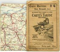
Cartes Taride
Carte Routiere No. 4 Paris Normandie Nord
Paris: Cartes Taride. Good with no dust jacket. Softcover. Front cover is soiled. Price sticker obscures part of front cover label. ; French text. Folded map issued with a cloth backing. . Cartes Taride paperback
Referência livreiro : 263735
|
|
|
Cartes Taride
Carte Routiere No. 26 Les Bords Du Rhin Cologne A Mayence
Paris: Cartes Taride. Very Good- with no dust jacket. Softcover. Covers are somewhat darkened. Price sticker obscures part of front cover label. ; French text. Folded map issued with a cloth backing. . Cartes Taride paperback
Referência livreiro : 263734
|
|
|
Cartes Taride
Carte Routiere No. 9 Bretagne Sud
Paris: Cartes Taride. Very Good- with no dust jacket. Softcover. Covers are slightly darkened. Price sticker obscures part of front cover label. ; French text. Folded map issued with a cloth backing. . Cartes Taride paperback
Referência livreiro : 263732
|
|
|
Cartes Taride
Carte Routiere No. 2 Lorraine Luxembourg
Paris: Cartes Taride. Very Good- with no dust jacket. Softcover. Covers are somewhat darkened. ; French text. Folded map issued with a cloth backing. . Cartes Taride paperback
Referência livreiro : 263731
|
|
|
Cartes Taride Paris.
Carte Taride. Routière No. 5. Normandie Ouest Bretagne Nord.
Cartes Taride Paris ca. 1925. Western Normandy & northern Brittany before World War II. Routes are numbered & measured. Shows the Channel Islands and ferry routes. Scale 1/250000; printed in four colors. 73x92 cm. accordion-folded to 19x12 cm. Protective folder is browned with age but the map has had little use & is VG. 28947 Fifi Cartes Taride, Paris [ca. 1925?] unknown
Referência livreiro : 28947
|
|
|
Cartes Taride No.
Cartes Taride No. 1 Routi�re Nord De La France Belgique Hotels Et Garages Recommands
Cartes Taride 18 Et 20 Boulevard St 1923. No binding. Used; Acceptable. French language. Map No One. Slipcase torn. <p><i><strong>Fast Dispatch. Expedited UK Delivery Available. Excellent Customer Service. </strong></i> <br/><br/>Bookbarn International Inventory #2795935</p> Cartes Taride 18 Et 20 Boulevard St unknown
Referência livreiro : 2795935
|
|
|
Cartes Taride
Collection Des Cartes Taride Petite Carte De France
C. S. Hammond & Company. Circa 1920. Paperback. Good. Light shelf wear on the covers and map. 26.5 x 24 inches a map of France circa 1920 C. S. Hammond & Company paperback
Referência livreiro : 14971

|
|
|
Cartes Taride
Grand Carte Routiere Centre De La France Section Est Bourgogne - Nivernais - Bourbonnais No. 1
Paris: A. Taride. Very Good- with no dust jacket. Softcover. Envelope is torn down one side and has general light wear. Map is clean. Price label and Brentano's ink stamp on the front of the envelope. ; French text. Folded map issued in a paper envelope. . A. Taride paperback
Referência livreiro : 263741
|
|
|
Cartes Taride
Grand Carte Routiere Bretagne Nord No. 5
Paris: A. Taride. Very Good- with no dust jacket. Softcover. Envelope has general light wear. Map is clean. ; French text. Folded map issued in a paper envelope. . A. Taride paperback
Referência livreiro : 263740
|
|
|
Cartes Taride
Guide Taride Paris Par Arrondissements Danlieue Desservie Par Le Metro Metro Autobus / Plan-Guide De Paris -- Includes Required Fold-out Maps
Cartes Taride Hard Cover - Good - No dust jacket if issued - Repair to interior hinge and cover wear otherwise clean and tight - Text in French - Includes required fold-out maps - 304 pages. - Circa 1950's. Hard Cover. Good. Cartes Taride Hardcover
Referência livreiro : 247930
|
|
|
Cartes Taride
Lyonnais Savoie Dauphin� Carte Routi�re No. 14 bis 1:250000
Cartes Taride 1930. Book. Fair. Map. Folded map is a little tanned and has some loss to some of the folds otherwise would be in good condition; card sleeve rather tanned and shelfworn. Undated but cloche-hatted lady on front would imply 1920s or early 1930s. 'Un enfant peut guider sa m�re avec les Cartes Taride Routi�res - elles sont claires pr�cises faciles � lire et indiquent en rouge les meilleurs itin�raires.'. Cartes Taride Paperback
Referência livreiro : 16061301-115

|
|
|
Cartes Taride:
Lyonnais: Savoie Dauphine
Cartes Taride Pour Cyclistes Et Automobilistes Paris no date: 1930's Cloth backed folding coloured map; No. 14 in the series; Some staining vg. Book. Cartes Taride Pour Cyclistes Et Automobilistes, Paris, no date: 1930's ? hardcover
Referência livreiro : 7369

|
|
|
Cartes Taride:
Midi De La France: section centrale
Cartes Taride Pour Cyclistes et Autmobiles Paris no date : 1930's Linen-backed folding coloured map; No. 18 in the series; Somewhat dirtied 'Royal Automobile Club Touring Department' stamp also a previous private owner's signature vg. Book. Cartes Taride Pour Cyclistes et Autmobiles, Paris, no date : 1930's ? unknown
Referência livreiro : 7368

|
|
|
Cartes Taride Firm
Paris par Arrondissement
Cartes Taride 1/1/1923. Paperback. Good. 127 pages : 24 color maps ; 15 cm. Bound in publisher's blue cloth. Silver lettering. Contents: Indicateur des rues --Autobus --Tramways --Metropolitain --Nord-Sud --Plans de Bois de Boulogne et de vincennes --Plan d'ensemble de Paris. Cartes Taride paperback
Referência livreiro : 1612300002

|
|
|
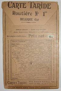
Cartes Taride
Road Map Belgium Carte Taride. Routiere No. 1. Belgique
Paris: Cartes Taride no date. Circa 1920s Large folding road map of Belgium. A detailed map showing routes distances signage and other features. Printed in four colors on heavy paper stock -- "sur papier simili-japon." Approx. 28.5 by 35.5 inches when unfolded. 4.75 by 7.5 inches in the protective folder. Front of the folder depicts a map of France and environs with other numbered routes from the Cartes Taride series. VG condition. Map is clean bright and unmarked. A few small pinholes at the folds and a couple of minor separations an inch or so also at the folds. unknown
Referência livreiro : 000110
|
|
|
Cartes Taride
ROADMAP CARTE TARIDE - ROUTIERE NO. 4. PARIS NORMANDIE NORD
Paris: Imp. Gaillac. A roadmap of France. Measuring about 73.5 x 92.5 cm unfolded. Housed in the publisher's paper sleeve. Imp. Gaillac unknown
Referência livreiro : 290392
|
|
|
Cartes Taride
ROADMAP CARTE TARIDE - ROUTIERE NO. 4. PARIS NORMANDIE NORD
Paris: Imp. Gaillac. A roadmap of France. Measuring about 73.5 x 92.5 cm unfolded. Housed in the publisher's paper sleeve. Imp. Gaillac unknown books
Referência livreiro : 290392
|
|
|
CARTESIO, Renato (René Descartes)
Epistolae
Tre voll. I primi due sono stampati da Elzevirio nel 1668 (4 cc + 383 + 2 cc.; 2 cc. + 404 + 2 cc.; il terzo è stampato da Blaeu nell’83 (8 cc + 427). Piena pergamena, ottimi esemplari, raro e importante.
|
|
|
CARTESIO, Renato (René Descartes)
Meditationes De Prima Philosophia / Appendix, continens objectiones quintas & septimas in Renati Descartes Meditationes (+ Epistola ... Ad ... D. Gisbertum Voetium / Principia Philosophiae
In -4° P. Pergamena, tre volumi rilegati assieme: B, (12) 191 (1 b.); 164 (appendix), 88 (epistola a Voetius, la numerazione riparte); 18 cc., 222, 3 cc. B. Nelle “Meditationes”, opera volta a stabilire cosa possa essere conosciuto con certezza, Cartesio adopera per la prima volta l’espressione “Cogito ergo sum”. L’“Appendix” si trova solitamente rilegata con le “Meditationes” ma ha un frontespizio e numerazione autonoma delle pp. così come autonoma è la numerazione della successiva Epistola al teologo olandese Voetius, suo avversario. Volume a sé (ma rilegato con questi) è i “Principia”, che fu peraltro stampato nell’anno successivo.
|
|
|
CARTESIO, Renato (René Descartes)
Specimina philosophiae seu dissertatio de methodo ... Dioptrice et Meteora / Passiones Animae
In -4° P. Pergamena, due volumi rilegati assieme: 8 cc + 248; 92 + 2 cc (Passiones)
|
|
|
Caruso John Anthony. Maps by Neil E. Bolyard
Mississippi Valley Frontier: The Age of French Exploration and Settlement
Indianapolis: Bobbs-Merrill 1966. 423 pp. maps in text. With ownership name stamp of anthropologist Richard Erdoes. Covers a bit dull page edges tanned and dusty. Jacket stained at spine dustsoiled lightly edgeworn. First Edition. Hard Cover. Very Good/Good. 8vo. Bobbs-Merrill Hardcover
Referência livreiro : C8430
|
|
|
Caruso John Anthony/Bolyard Neil E. maps
The Mississippi Valley Frontier: The Age of French Exploration and Settlement
Indianapolis: Bobbs Merrill Co. 1966. 1st printing. VG/VG dust jacket name on front endpaper/bottom fore-edge. xiv 423 p. maps notes biblio index 8vo; Bobbs Merrill Co. hardcover
Referência livreiro : 51625

|
|
|
Carver Jonathan Robert Sayer and John Bennett Firm publisher Library of Congress. American maps ; v. no. .
A new map of the province of Quebec according to the Royal Proclamation of the 7th of October 1763. : From the French surveys connected with those made after the war. 1776 Leather Bound
2019. Leather Bound. New. Leather Binding on Spine and Corners with Golden Leaf Printing on round Spine extra customization on request like complete leather Golden Screen printing in Front Color Leather Colored book etc. Reprinted in 2019 with the help of original edition published long back 1776. This book is printed in black & white sewing binding for longer life Printed on high quality Paper re-sized as per Current standards professionally processed without changing its contents. As these are old books we processed each page manually and make them readable but in some cases some pages which are blur or missing or black spots. If it is multi volume set then it is only single volume if you wish to order a specific or all the volumes you may contact us. We expect that you will understand our compulsion in these books. We found this book important for the readers who want to know more about our old treasure so we brought it back to the shelves. Hope you will like it and give your comments and suggestions. Lang: - English. EXTRA 10 DAYS APART FROM THE NORMAL SHIPPING PERIOD WILL BE REQUIRED FOR LEATHER BOUND BOOKS. COMPLETE LEATHER WILL COST YOU EXTRA US$ 25 APART FROM THE LEATHER BOUND BOOKS. hardcover
Referência livreiro : LB1111009007583
|
|
|
Carver Jonathan Robert Sayer and John Bennett Firm publisher Library of Congress. American maps ; v. no. .
A new map of the province of Quebec according to the Royal Proclamation of the 7th of October 1763. : From the French surveys connected with those made after the war. 1776 FULL LEATHER BOUND
2019. SUPER DELUXE EDITION. New. Antique look with Golden Leaf Printing and embossing with round Spine completely handmade bindingextra customization on request like Color Leather Colored book special gold leaf printing etc. Reprinted in 2019 with the help of original edition published long back 1776. This book is printed in black & white sewing binding for longer life Printed on high quality Paper re-sized as per Current standards professionally processed without changing its contents. As these are old books we processed each page manually and make them readable but in some cases some pages which are blur or missing or black spots. If it is multi volume set then it is only single volume if you wish to order a specific or all the volumes you may contact us. We expect that you will understand our compulsion in these books. We found this book important for the readers who want to know more about our old treasure in old look so we brought it back to the shelves. Hope you will like it and give your comments and suggestions. Lang: - English. EXTRA 10 DAYS APART FROM THE NORMAL SHIPPING PERIOD WILL BE REQUIRED. Normal Hardbound Edition is also available on request. unknown
Referência livreiro : SD1111009007583
|
|
|
Carver Jonathan Robert Sayer and John Bennett Firm publisher Library of Congress. American maps ; v. no. .
A new map of the province of Quebec according to the Royal Proclamation of the 7th of October 1763. : From the French surveys connected with those made after the war. 1776
2019. Paperback. New. Lang: - English. Reprinted in 2019 with the help of original edition published long back 1776. This book is Printed in black & white sewing binding for longer life with Matt laminated multi-Colour Soft Cover HARDCOVER EDITION IS ALSO AVAILABLE Printed on high quality Paper re-sized as per Current standards professionally processed without changing its contents. As these are old books we processed each page manually and make them readable but in some cases some pages which are blur or missing or black spots. If it is multi volume set then it is only single volume if you wish to order a specific or all the volumes you may contact us. We expect that you will understand our compulsion in these books. We found this book important for the readers who want to know more about our old treasure so we brought it back to the shelves. Any type of Customisation is possible with extra charges. Hope you will like it and give your comments and suggestions. paperback
Referência livreiro : PB1111009007583
|
|
|
Carver Jonathan Robert Sayer and John Bennett Firm publisher Library of Congress. American maps ; v. no. .
A new map of the province of Quebec according to the Royal Proclamation of the 7th of October 1763. : From the French surveys connected with those made after the war. 1776 Hardcover
2019. Hardcover. New. Lang: - English. Reprinted in 2019 with the help of original edition published long back 1776. This book is Printed in black & white Hardcover sewing binding for longer life with Matt laminated multi-Colour Dust Cover Printed on high quality Paper re-sized as per Current standards professionally processed without changing its contents. As these are old books we processed each page manually and make them readable but in some cases some pages which are blur or missing or black spots. If it is multi volume set then it is only single volume if you wish to order a specific or all the volumes you may contact us. We expect that you will understand our compulsion in these books. We found this book important for the readers who want to know more about our old treasure so we brought it back to the shelves. Any type of Customisation is possible with extra charges. Hope you will like it and give your comments and suggestions. hardcover
Referência livreiro : 1111009007583
|
|
|
Cary, John
A new map of the circles of the upper and lower Rhine. 1799. [Original-Kupferstich / original copper engraving].
o.J. [3 Warenabbildungen] (John Cary, geb. ca. 1754, gest. 1835, englischer Kartograph, Graveur, Globenmacher und Verleger).
Referência livreiro : 66506CB

|
|
|
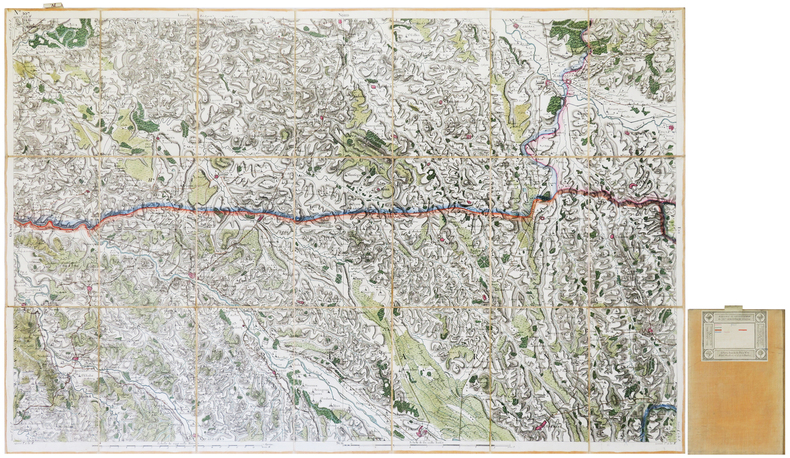
CASSINI de THURY (César-François).
[AGEN] Carte de Cassini. Feuille n°73/18.T. Agen.
[Paris, circa 1810]. En 21 sections montées sur toile et repliées, formant une carte de 593 x 925 mm ; onglet de vélin renseigné du numéro de la feuille en manuscrit ; étiquette au dos de l'éditeur parisien Charles Simonneau portant une légende de trois couleurs.
Referência livreiro : LBW-7940
|
|
|
CASSINI de THURY (César-François).
[AIRE-sur-l'ADOUR/ORTHEZ] Carte de Cassini. Feuille n°107/99. Aire-sur-l'Adour.
[Paris, 1756-1789]. En 21 sections montées sur toile et pliées, formant une carte de 591 x 925 mm ; étiquette au dos portant le titre "Aire" et le numéro en manuscrit.
Referência livreiro : LBW-7128
|
|
|
CASSINI de THURY (César-François).
[AIRE-sur-l'ADOUR/ORTHEZ] Carte de Cassini. Feuille n°107/19.E. Aire et Orthez.
[Paris, circa 1810]. En 21 sections montées sur toile et repliées, formant une carte de 594 x 923 mm ; onglet de vélin renseigné du numéro de la feuille en manuscrit ; étiquette au dos de l'éditeur parisien Charles Simonneau portant une légende de cinq couleurs.
Referência livreiro : LBW-7942
|
|
 Receber por correio electrónico
 Descarregar em documento PDF
 Fluxo RSS


