|
Erich Bachman, Burkard von Roda and Werner Hemlbeger (editors)
The Wurzburg Residence and Court Gardens
Book in mint condition. 200pp. History and description of the German Palace in Wurzburg between Frankfurt and Nuremberg, considered to be the most beautiful Palace in the country. Very well illustrated.

|
|
|
Erickson C. E. Maps
The High Sierra and Its Environs - Sunset Sportman's Atlas
Lane Publishing Co. 1955-01-01. Paperback. Good. 10.9000 inches 8.5000 inches. Lane Publishing Co. paperback
Référence libraire : mon0001836827
|
|
|
Erna Fergusson SIGNED & INSCRIBED by Author End papers are nautical maps of the Hawaiian Islands surrounded by the Pacific Oce
Our Hawaii of this history and travelogue through Hawaii
A.A. Knopf New York 1942 HARDBACK NODustjacket 1942 Stated 1st EDITION First Printing NF/NF NOJACKET Dates Match on title & Copyright pg bound in GREEN buckram cloth with Gilt design & title 304 pages of clean bright highly illustrated text with no dust jacket Title and a decoration device are embossed into the front cover in bright gilt. Title Author's name as well as two decorative devices are embossed into the spine in bright gilt. Interior nice tight clean Light Wear Fox Index. Signed by Authors. 1st Edition. Hardcover. Near Fine/No Jacket. A.A. Knopf, New York, hardcover
Référence libraire : 27092
|
|
|
Escher, Arthur; Watt, W. Stuart: Editors. Ellitsgaard-Rasmussen, K. (Preface)
Geology of Greenland
603 pages. Index. Footnotes. Black and white photos. Fold-out maps. Printed upon glossy stock. "Aims to provide a concise modern account of nearly all aspects of Greenland's geology." - from Preface. Small inkstamp atop front free endpaper, otherwise unmarked with light wear. Binding sound. A quality copy of this highly-informative academic work. Book

|
|
|
ESCOLANO UTRILLA, Severino (Director).
Atlas de Geografía de Aragón.
Zaragoza, Institución Fernando el Católico, 1995. Folio; 99 dípticos y trípticos con texto, gráficos y mapas, encartados en estuche en cartoné.

|
|
|
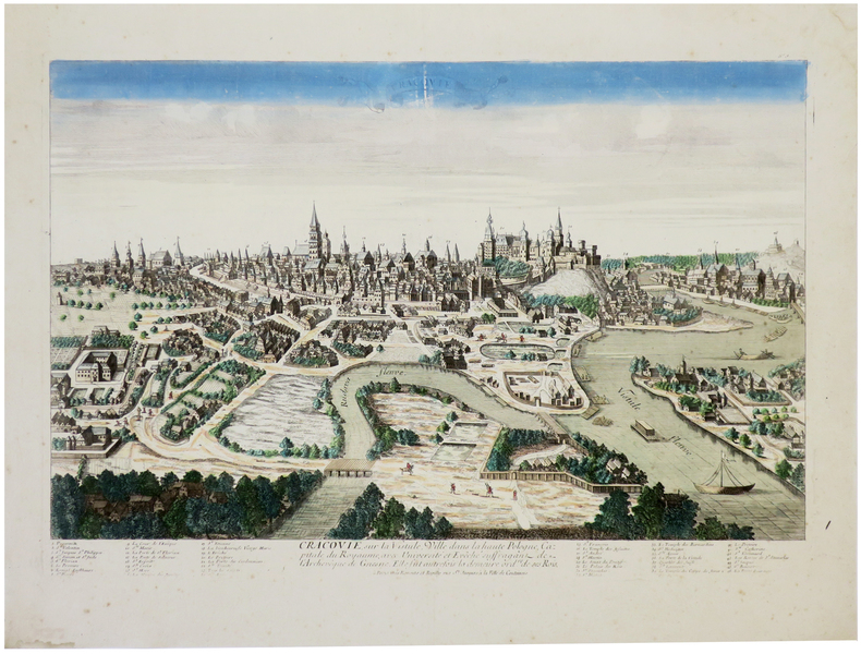
ESNAUTS (Jacques) & RAPILLY (Michel).
[CRACOVIE] Cracovie, sur la Vistule, ville dans la haute Pologne, capitale du royaume.
Paris, Esnauts et Rapilly, [circa 1760]. 347 x 515 mm.
Référence libraire : LBW-6313
|
|
|
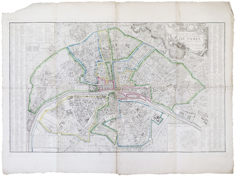
ESNAUTS (Jacques) & RAPILLY (Michel).
Nouveau plan routier de la ville & faubourgs de Paris divisé en 48 sections d'après le décret de l'Assemblée N.ale.
Paris, Esnauts et Rapilly, 1792. En 21 sections montées sur toile et pliées, formant un plan de 0,67 x 1,09 m.
Référence libraire : LBW-6241

|
|
|
ESNAUTS (Jacques) & RAPILLY (Michel).
Nouveau plan routier de la ville & faubourgs de Paris divisé en 12 arrondissemens ou municipalités.
Paris, Esnauts et Rapilly, 1797. 0,65 x 1,05 m.
Référence libraire : LBW-6291
|
|
|
Esposito, Vincent J. (ed.)
West Point Atlas of the Civil War
14" wide x 10.5" tall book in excellent condition.with very handsome blue spine and grey cloth covers with large gilt print. Binding is solid and square, covers have sharp corners, exterior shows no blemishes, text/interior is clean and free of marking of any kind with full page very detailed maps on heavy paper, text on opposite page. Dust jacket shows edge wear, small tears, price clipped. From flyleaf: "Utilizing a technique revolutionary in military writing, that of combined map and adjoining text, Col. Esposito and his staff present clearly and concisely, ., the events of the military campaigns and the factors that influenced the course of action and the outcome of the civil War. The battle maps do not merely portray static situations; they are dynamic, with many map sequences clearly showing the movements of the opposing forces from day to day, sometimes from hour to hour. Moreover, each map is accompanied by text on the opposite page; while the theme is developed in the map, this supplementary narrative explains and comments on the situation pictured. The nineteen major campaigns of the war are carefully detailed in this manner. Explanatory symbols in color make clear troop movements, time sequences, numerical strength of units, boundaries, fortifications, and all the other elements necessary for an understanding of the strategies and tactics involved in the campaigns and specific battles." Chronological chart, large bibliography, plus maps of the Colonial wars, Revolutionary War, 1812, Mexicqn war,

|
|
|
ESQUER, Gabriel.
Iconographie historique de l’Algérie depuis le seizième siècle jusqu’à 1871. (Collection du Centenaire de l’Algérie, 1830 – 1930).
Paris : Plon, 1929. 3 grands volumes in-folio ; 354 planches dont 18 en couleurs, tables des noms et des matières. En feuilles sous chemise cartonné à lacets. Quelques rousseurs sur les feuillets de texte préliminaire.TomeI: Texte. Planches I à 66 (XVIesiècle-1826); TomeII: Planches 67 à 217 (1827-1837); TomeIII: Planches 218 à 354 (1838-1871) Les planches rassemblent plus de mille illustrations constituées par des peintures, dessins, estampes, images populaires, sculptures, médailles, représentant des portraits, vues de ville et vues du pays.
Référence libraire : PHO-1046

|
|
|
ESQUIMAUX POLAIRES de THULE par Jean MALAURIE.
Les derniers rois de Thulé. Avec les esquimaux polaires, face à leur destin. 89 illustrations ; 11 cartes.
CFL/Plon 1986 (4e éd.). Bel exemplaire relié, jaquette, fort in-8, 642 pages + planches.
Référence libraire : AUB-6306
|
|
|
Esri
ESRI Map Book Beography and GIs Sustaining OUr World
good. paperback. cover and corner wear. Vol 17. creased covers. paperback
Référence libraire : B70719xxxN18472 ISBN : 1589480481 9781589480483
|
|
|
Essame Hubert 1896 jacket design Jerry Thorp; illustration Bill Mauldin; maps Arthur Banks
Patton : A Study in Command. Morocco; The Cannae Manoeuvre; Lorraine; Ardennes; etc
New York : Charles Scibner's Sons 1974. 1974. Very Good. Book Club Edition; black pressed boards with gold lettering in photographic dustjacket ; x 280 p. illus. 24 cm. ; ISBN: 0684136716; LCCN: 73-15498 ; OCLC: 871338 ; 8 maps ; several photographs ; foxing some fading else VG/VG New York : Charles Scibner's Sons, 1974. hardcover
Référence libraire : 2742

|
|
|
Esso
Esso road map : Northern England
Revised edition. 1 folded map. Very Good condition. (Section ; no. 5). 50977. eng
|
|
|
Esso Staff
Esso Guia Turistica De America Del Sur (Esso South American Road Map)
24" x 34". Text in Spanish. Back side shows the continent overlaid with small color illustrations of dozens of items of local interest. Undated but appears to be circa late 1950s. Library markings. Average wear. A sound copy. Book

|
|
|
ESTIVALS (Robert), GAUDY (Jean-Charles).
La Bibliologie graphique.. L'évolution graphique des plans de Paris (1530-1798)
Paris, Société de bibliologie et de schématisation, 1983 in-8, 296 pp., impression en partie sur papier rouge, en partie sur papier bleu, avec des illustrations dans le texte, broché.
Référence libraire : 227987

|
|
|
ESTEBE (Léon-Mary).
Villeneuve de Berg.
Villeneuve de Berg, association-Services "le Prieuré", s.d. (années 80 ou 90), 1 carte postale de 10 x 15 cm ;
Référence libraire : 7535
|
|
|
Estournelles de Constant, Paul Henri Benjamin, Baron d' (1852-1924).
LES ETATS-UNIS D'AMERIQUE.
pp. ix, 536 + Folding map. 12mo. Handsome contemporary leather backed marbled boards binding. An interesting and wide-ranging study of important aspects of American life before World War One. Scarce. **PRICE JUST REDUCED! FR5
|
|
|
Etang de Berre.Dépôt général de la Marine ,1848.
Côtes de France. Etang de Berre. Carte levée en 1844, publiée en 1848
1844 Côtes de France. Etang de Berre. Carte levée en 1844, publiée en 1848 Imp. du Sémaphore. Gravure, 1848. 63 x 50 cm.
Référence libraire : 22824
|
|
|
Etablissements LABOUCHE Frères
Nouveau Plan De Toulouse avec Les Nouvelles Dénominations De Certaines Voies Publiques Courant Avril 1946 après L'impression Du Plan
Toulouse Labouche Frères 1946 In 16 Très beau plan lithographié et plié de 53 cm X 70 cm en couleurs à l'échelle 1/10 000°de la ville de Toulouse . Quelques défauts d'usages sur la couverture mais le plan est parfait .- 1 p. , 250 gr.
Référence libraire : 007288

|
|
|
Etablissements LABOUCHE Frères
Nouveau Plan De Toulouse avec Les Nouvelles Dénominations De Certaines Voies Publiques Courant Avril 1946 après L'impression Du Plan
Très beau plan lithographié et plié de 53 cm X 70 cm en couleurs à l'échelle 1/10 000°de la ville de Toulouse . Quelques défauts d'usages sur la couverture mais le plan est parfait .- 1 p. , 250 gr.
|
|
|
EUGÈNE-HENRI FRICX
Table des cartes des Pays Bas et des frontieres de France, avec un recueil des plans des villes, siéges et batailles données entre les hauts allies et la France. - [ONE OF THE MOST IMPORTANT MAP PUBLISHERS IN THE SOUTHERN NETHERLANDS]
Brussels, 1712. Folio (512 x 315 mm). In contemporary half calf with seven raised bands. Spine and hindges with wear. Leather brittle and upper and lower 10 cm hindges detached. Two library labels pasted on to pasted down front end-paper. Upper margin of first three leaves blind-stamped. Handwritten (19th century hand) index mounted in on verso of first map and each map numbered. With 75 maps and plans, many double-page or folding: 24 cartes des Pays Bas, Carte générale de Brabant, Carte du Pays de Waes, Carte des Postes d'Allemagne, 48 plans des Villes, Sièges & Batailles (complete). 3 maps with minor marginal tear (outside plate), 2 with minor split to lower part of middle folding. A few maps at end with browning. A few plates (primarily 61, 50, 33, 25) heavily trimmed with slight loss to upper margin. An overall fine and clean copy.
Référence libraire : 60165
|
|
|
EUGÈNE-HENRI FRICX
Table des cartes des Pays Bas et des frontieres de France, avec un recueil des plans des villes, siéges et batailles données entre les hauts allies et la France.
Brussels, 1712. Folio (512 x 315 mm). In contemporary half calf with seven raised bands. Spine and hindges with wear. Leather brittle and upper and lower 10 cm hindges detached. Two library labels pasted on to pasted down front end-paper. Upper margin of first three leaves blind-stamped. Handwritten (19th century hand) index mounted in on verso of first map and each map numbered. With 75 maps and plans, many double-page or folding: 24 cartes des Pays Bas, Carte générale de Brabant, Carte du Pays de Waes, Carte des Postes d'Allemagne, 48 plans des Villes, Sièges & Batailles (complete). 3 maps with minor marginal tear (outside plate), 2 with minor split to lower part of middle folding. A few maps at end with browning. A few plates (primarily 61, 50, 33, 25) heavily trimmed with slight loss to upper margin. An overall fine and clean copy.
|
|
|
EULER Leonhard (Basilea 1707 - San Pietroburgo 1783)
Tabula Geographica Hemisphaerii Australis...
Carta a proiezione polare dell'emisfero australe, pubblicata per la prima volta nel 1753 da Leonhard Euler.Mostra la Tasmania e la Nuova Guinea ancora uniti all'Australia; il Sud Africa e il Sud America. Include un cartiglio decorativo con titolo e stemmi.La carta è pubblicata nel raro Atlas geographicus omnes orbis terrarum regiones in XLI tabulis exhibens : jussu Academiae regiae scient. et eleg. litt. Boruss. ad emendatiora, quae adhuc prodiere exempla descriptus atque ad usum potissimum scholarum et institutionem juventutis editus = Atlas geographique representant en XLI cartes toutes les regions de la terre : gravé par ordre de l'Académie royale des sciences et belles lettres de Prusse d'apres les meilleurs exemplaires qui ayent paru jusqu'icy a l'usage principalement des ecoles. Berolini : Ex officina Michaelis MDCCLIII (1753). Incisione in rame, bella coloritura coeva, in ottimo stato di conservazione. Hand colored copperplate engraving map of Southern Hemisphere on 2 sheets, extracted from a geographical atlas first published in 1753 by Leonhard Euler. Relief shown pictorially. Shows Tasmania and New Guinea still joined to Australia, South Africa, South America. Published in the rare Atlas geographicus omnes orbis terrarum regiones in XLI tabulis exhibens : jussu Academiae regiae scient. et eleg. litt. Boruss. ad emendatiora, quae adhuc prodiere exempla descriptus atque ad usum potissimum scholarum et institutionem juventutis editus = Atlas geographique representant en XLI cartes toutes les regions de la terre : gravé par ordre de l'Académie royale des sciences et belles lettres de Prusse d'apres les meilleurs exemplaires qui ayent paru jusqu'icy a l'usage principalement des ecoles. Berolini : Ex officina Michaelis MDCCLIII.Copperplate with fine origibal colour, very good condition.

|
|
|
EULER Leonhard (Basilea 1707 - San Pietroburgo 1783)
Tabula Geographica Hemisphaerii Borealis…
Carta a proiezione polare dell'emisfero boreale, estratta dall'atlante geografico pubblicato per la prima volta nel 1753 da Leonhard Euler.Mostra un vasto sistema fluviale nella zona dei Grandi Laghi che forma un Passaggio a Nord-Ovest.La carta è pubblicata nel raro Atlas geographicus omnes orbis terrarum regiones in XLI tabulis exhibens : jussu Academiae regiae scient. et eleg. litt. Boruss. ad emendatiora, quae adhuc prodiere exempla descriptus atque ad usum potissimum scholarum et institutionem juventutis editus = Atlas geographique representant en XLI cartes toutes les regions de la terre : gravé par ordre de l'Académie royale des sciences et belles lettres de Prusse d'apres les meilleurs exemplaires qui ayent paru jusqu'icy a l'usage principalement des ecoles. Berolini : Ex officina Michaelis MDCCLIII (1753). Incisione in rame, bella coloritura coeva, in ottimo stato di conservazione. Hand colored copperplate engraving map of Northern Hemisphere, extracted from a geographical atlas first published in 1753 by Leonhard Euler. Relief shown pictorially. Shows extensive river system connecting it with the Great Lakes and thus forming a Northwest Passage.Published in the rare Atlas geographicus omnes orbis terrarum regiones in XLI tabulis exhibens : jussu Academiae regiae scient. et eleg. litt. Boruss. ad emendatiora, quae adhuc prodiere exempla descriptus atque ad usum potissimum scholarum et institutionem juventutis editus = Atlas geographique representant en XLI cartes toutes les regions de la terre : gravé par ordre de l'Académie royale des sciences et belles lettres de Prusse d'apres les meilleurs exemplaires qui ayent paru jusqu'icy a l'usage principalement des ecoles. Berolini : Ex officina Michaelis MDCCLIII.Copperplate with fine origibal colour, very good condition.

|
|
|
EUROPE
L'Europe méridionale par Élisée RECLUS. Richt documenté (74 gravures, 4 cartes en couleurs, 174 cartes dans le texte). Grèce, Turquie, Roumanie, Italie, Espagne et Portugal).
Paris, éd. Hachette 1879. Bon exemplaire relié, reliure demi cuir ornée d'éd., fort et pet in-4, IV + 1012 pages + planches.
Référence libraire : AUB-5688
|
|
|
EURE
Carte d?partementale en couleurs. Sans date.
Une feuille 80x60 cm.
|
|
|
Euro Maps
Romania Moldavia. Scale 1:800000. Euro Country Map
GeoCenter 1995. First Edition. Fine map in protective card-board folded case. Series; Euro maps 33228. Physical description; Map. Genre; Miscellany. Notes; Scale 1:800 000 Includes index. Subjects; Map. Romania. Genre; Euro maps. GeoCenter unknown
Référence libraire : 232724 ISBN : 3575332282 9783575332288

|
|
|
Europcar
Nederland Road Map
Scale 1: 300000, colour map, no publication date (1980s?). eng
|
|
|
EUROPE / CHROMOLITHOGRAPH MAPS D'Auray Jean
Promenades Autour du Monde. Le Tour D'Europe.
Paris.: Librairie de Théodore Lefévre et Co. No date. Ca. 1888. Illustrated children's book 10 only of 12 chromolithographic plates present color pictorial paper-covered boards with cloth spine 9 1/2 x 11 inches. Considerable wear and spotting to covers the text block is loose except in places where tape has been applied to hold the book together The color plates feature a centrally positioned child with a map of the country and pictorial aspects of the country less prominently shown. Countries represented are France Belgium Belgique Holland Hollande Suède et Norvège Sweden and Norway Allemagne Germany Russie Russia Turquie Turkey Autriche-Hongrie Austria-Hungary Italie Italy Espagne Spain et Portugal. Missing are the British Isles and Switzerland Iles Britanniques and Suisse. Held by four libraries in Europe. . Librairie de Théodore Lefévre et Co. hardcover
Référence libraire : 55092
|
|
|
Evans Vivienne; photographs and maps by Lewis Evans
Exploring History All Around
Dunstable: The Book Castle 2002. Paperback. First Edition. 8vo. Softcover. Local history in the Beds Herts Bucks area. 295 pp. B/w plates and maps. Clean and bright. VG <br/><br/> The Book Castle paperback
Référence libraire : 7877
|
|
|
Evans, Lindsay
The Castles of Wales
No marks or inscriptions. A lovely clean very tight copy with bright unmarked boards and no bumping to corners. Dust jacket not price clipped or marked or torn with minor crease near top of sunned spine. 273pp. A study of the strongholds of the Edwardian Conquest in North Wales and the Norman defences in South Wales. Well illustrated.

|
|
|
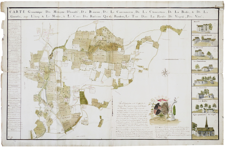
EVEN. MANUSCRIT.
Carte géométrique des mettayries d'Houzillé, du Boisroux, de la Couvenancière, de la Chenevettière, de la Brosse, & de la Guenesse, avec l'étang & le moulin, & le cours des ruisseaux qui s'y rendent ; le tout dans la paroisse de Vergeal, près Vitré.
Houzillé, 3 avril 1778. 670 x 1020 mm.
Référence libraire : LBW-2821
|
|
|
Eve Grey Illustrated by Tambi Larsen Maps by Charles A. Williams
Legends of Micronesia Book Two
-: High Commissioner Trust Territory of the Pacific Islands Dept of Education 1951. Hardcover. Very Good-/Good. used hardcover in dj. covers lightly scuffed moderate sun fading to dj crown and front and rear hinges and spine no major tears not price-clipped now in mylar cover. mild wear binding is solid text is clean boards lightly scuffed with mild bump at bottom fore-edge corners and lightly bowed but clean page edges lightly scuffed and lightly dirty. High Commissioner Trust Territory of the Pacific Islands, Dept of Education hardcover
Référence libraire : 10000000105008
|
|
|
EVEREST
Les premi?res cartes de l'Everest. Article (1 page, 2 cartes) dans L'Illustration.
Num?ro sans publicit?s.
|
|
|
Everhart William C. & Photos & Maps
Vicksburg
National Park Service. Near Fine. 1954. Paperback. 60 pp; Cover lightly rubbed and a little shelf wear light crease on upper front corner illustration in great shape original price stamped on front cover 25 cents no names pages unmarked. A very nice clean tight pamphlet. . National Park Service paperback
Référence libraire : 791966
|
|
|
EVOLUTION HUMAINE, ouvrage publié sous la dir. de M. LAHY-HOLLEBECQUE.
L'évolution humaine des origines à nos jours. Richement documenté (Planches en couleurs, cartes, héliogravures, gravures, figures).
Paris, A. Quillet 1951. 4 beaux volumes reliés, reliures demi cuir ornées d'éd., forts in-4, plus de 2000 pages.
Référence libraire : AUB-3999
|
|
|
Ewert, Henry
The Story of the B.C. Electric Railway Company
336 pages including index. "The British Columbia Electric Railway consisted of 111 route miles of streetcar operations in four cities: seven interurban lines totaling 141 route miles; 40 million passengers carried in 1910, and almost 146 million in 1947. For 68 years - 1890 to 1958 - the streetcars and trams dominated and defined urban and interurban transportation in the most populated areas of B.C. Today only traces remain of this fascinating and well-run system that once brought people from all over the world to examine its operation. Includes over 270 fascinating illustrations, plans of rolling stock, tickets, transfers, beautiful route maps, public schedules, employee's timetables, rosters of rolling stock and old Buzzers." - from dust jacket. An amazing, and perhaps unbelievable, reference for residents of the now grid-locked lower mainland. Very heavily worn. Front hinge partially open. Usual library markings. A worthy reading copy. Ex-Library

|
|
|
Ewert, Henry
The Story of the B.C. Electric Railway Company
336 pages including index. "The British Columbia Electric Railway consisted of 111 route miles of streetcar operations in four cities: seven interurban lines totaling 141 route miles; 40 million passengers carried in 1910, and almost 146 million in 1947. For 68 years - 1890 to 1958 - the streetcars and trams dominated and defined urban and interurban transportation in the most populated areas of B.C. Today only traces remain of this fascinating and well-run system that once brought people from all over the world to examine its operation. Includes over 270 fascinating illustrations, plans of rolling stock, tickets, transfers, beautiful route maps, public schedules, employee's timetables, rosters of rolling stock and old Buzzers." - from dust jacket. A wonderful and almost unbelievable reference for residents of the now grid-locked lower mainland of British Columbia. Very light wear. Clean, bright and unmarked. Partial lean to spine. Short opening to back panel of dust jacket which is now preserved in a glossy new archival-grade Brodart cover. A high-quality copy. Book

|
|
|
Ewing Heather maps by Reginald Piggott genealogy chart by Leslie Robinson Dust Wrapper design by Polly Napper illustrations b
THE LOST WORLD OF JAMES SMITHSON: SCIENCE REVOLUTION AND THE BIRTH OF THE SMITHSONIAN
New York: Bloomsbury 2007. Near Fine in Fine dust jacket. 2007. First Edition Thus. Hardcover. 1596910291 . First US edition. This copy has been inscribed signed and dated in the year of issue "April 2007" by the author on the title page. 432 pages illustrated including maps appendix: genealogy chart notes picture credits acknowledgments index. Near Fine copy very light spine end bumping in Fine Dust Wrapper.; Signed by Author . Bloomsbury [2007] hardcover
Référence libraire : 67702 ISBN : 1596910291 9781596910294

|
|
|
Exem:
Petite sérigraphie.
Au format 19 x 25 cm.
Référence libraire : 17945
|
|
|
EXNER, Christof:
Erläuterungen zur geologischen Karte der Umgebung von Gastein 1:50.000 (Ausgabe 1956).
Oktav, 23.3cm. [IV],168 S., 3 gefalt. Karten und 5 gefalt. Taf. mit Profilen in Tasche, 8 Abb. im Text, Bibliogr. Priv.-Halbleinen, Kurztitel auf Rücken, Vorderteil des Orig.-Umschlages aufgeklebt. Sehr gutes Exemplar. - Ohne die eigentliche Karte 1:50.000 (wie erschienen).
|
|
|
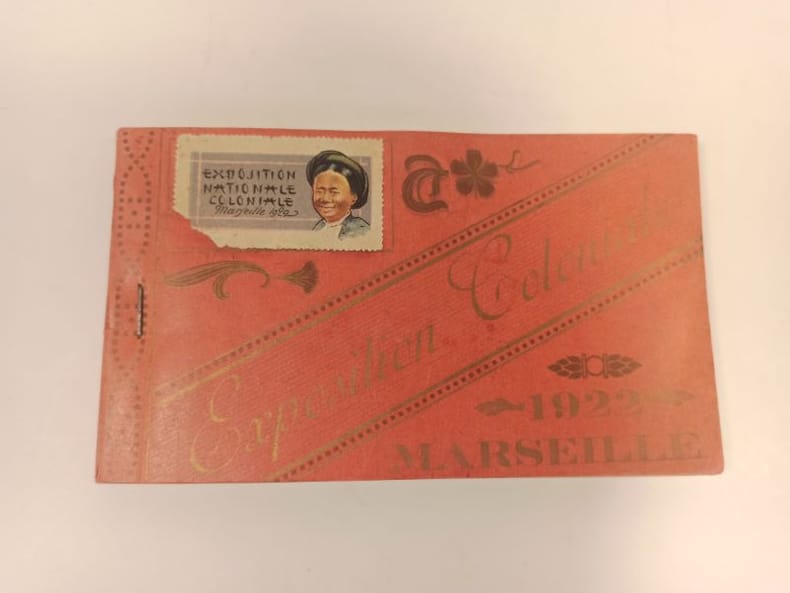
EXPOSITION COLONIALE)
Carnet complet de 24 poastales éditées à l'occasion de l'exposition coloniale de 1922, à Marseille.
1922 Format oblong broché (90 x 155 mmn) couverture rouge imprimée.
Référence libraire : 23662
|
|
|
EXPLORATEURS par Jean-Pierre CARTIER.
Explorateurs et explorations. Richement documenté (planches en couleurs, cartes, figures).
Ed. Larousse 1975. Bel exemplaire relié, reliure pleine toile et jaquette ornée d'éd., fort in-4, 400 pages.
Référence libraire : AUB-6774
|
|
|
EXPRESS MAPS
Brussels mini
Paperback. New. detaillierte Zentrumkarte interessante Orte U-Bahn-Netzplan Straßenregistershow more paperback
Référence libraire : ria9788375462500_new ISBN : 8375462500 9788375462500
|
|
|
EXPRESS MAPS
Brussels mini
Paperback. As New. detaillierte Zentrumkarte interessante Orte U-Bahn-Netzplan Straßenregistershow more paperback
Référence libraire : ria9788375462500_rkm ISBN : 8375462500 9788375462500
|
|
|
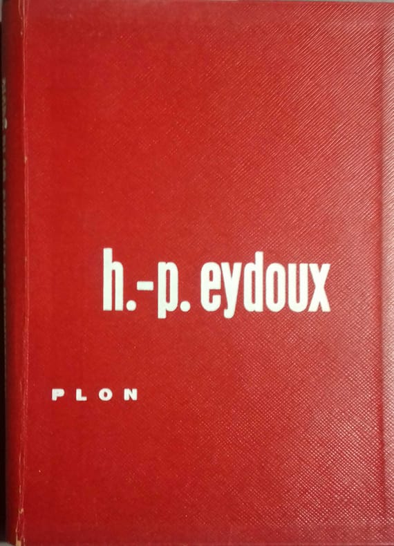
EYDOUX Henri-Paul 42 illustrations et cartes in-texte et 30 illustrations hors-texte.
Monuments et trésors de la Gaule. Les récentes découvertes archéologiques.
Couverture rigide. Cartonnage de l'éditeur. 267 pages.
Référence libraire : 137286
|
|
|
F J Monkhouse & H R Wilkinson:
MAPS AND DIAGRAMS Their compilation and Construction
VG (original green cloth, a little faded and marked, no dj) Octavo 432pp Profusely illustrated, many foldouts. Comprehensive
|
|
|
F. Cartes
Semana Nacional Del Libro Infantil Y Juvenil. Exhibition Poster
Madrid: National Institute of Spanish Books ca. 1970. Large format color print poster 25" x 12". Very Good. Minor creasing on top and bottom edges. Scarce. Text in Spanish. From the collection of the late Frederick Ruffner Jr. founder of Gale Research Detroit. Madrid: National Institute of Spanish Books, [ca. 1970] unknown
Référence libraire : 19-8996

|
|
|
Fabrizio Mancinelli
The Sistine Chapel
Probably unread. No marks or inscriptions. Very tiny creasing to lower corner of front cover, none to spine. A lovely clean very tight copy with bright unmarked boards and no bumping to corners. 112pp. The history and the art of the Sistine Chapel at the Vatican. We do not use stock photos, the picture displayed is of the actual book for sale. Every one of our books is in stock in the UK ready for immediate delivery.

|
|
 Recevoir par e-mail
 Télécharger en PDF
 Flux RSS


