|
International Travel Maps and Books
Turkmenistan / Tajikistan / Kyrgyzstan itm r/v r
International Travel Maps and Books. Map. New. 2nd edition edition. 9.92x4.25x0.31 inches. International Travel Maps and Books unknown
Referência livreiro : 2-1553418786 ISBN : 1553418786 9781553418788
|
|
|
International Travel maps
Tuscany Toscana Travel Reference Map
International Travel maps 2002-01-02. Map. Map. Used:Good. International Travel maps unknown
Referência livreiro : DADAX1553415574 ISBN : 1553415574 9781553415572

|
|
|
International Travel maps
Tuscany Toscana Travel Reference Map
International Travel maps 2002-01-02. Map. Good. International Travel maps unknown
Referência livreiro : SONG1553415574 ISBN : 1553415574 9781553415572
|
|
|
International Travel Maps and Books
Ukraine & Moldova / Crimea itm
International Travel Maps and Books. Map. New. International Travel Maps and Books unknown
Referência livreiro : 2-1553414535 ISBN : 1553414535 9781553414537
|
|
|
International Travel maps
USA East Half Travel Reference Map: 1:23m
International Travel maps 2012. Map. New. 1st edition. 2 pages. 9.53x3.86x0.39 inches. International Travel maps unknown
Referência livreiro : __1553419006 ISBN : 1553419006 9781553419006
|
|
|
International Travel maps
Vancouver & Greater Vancouver 1:20K/1:50K ITM Map
ITMB Publishing Ltd 2013-08-19. Map. Used:Good. ITMB Publishing, Ltd unknown
Referência livreiro : DADAX1553415191 ISBN : 1553415191 9781553415190
|
|
|
International Travel maps
Vancouver & Greater Vancouver 1:20K/1:50K ITM Map
2013-03-04. New. Ships with Tracking Number! INTERNATIONAL WORLDWIDE Shipping available. May be re-issue. Buy with confidence excellent customer service! unknown
Referência livreiro : 1553415191n ISBN : 1553415191 9781553415190

|
|
|
International Travel Maps
Waterproof Costa Rica Map
2006-04-07. New. Ships with Tracking Number! INTERNATIONAL WORLDWIDE Shipping available. May be re-issue. Buy with confidence excellent customer service! unknown
Referência livreiro : 1553411803n ISBN : 1553411803 9781553411802

|
|
|
International Travel Maps
Waterproof Costa Rica Map
2006-04-07. Good. Ships with Tracking Number! INTERNATIONAL WORLDWIDE Shipping available. May not contain Access Codes or Supplements. May be re-issue. May be ex-library. Shipping & Handling by region. Buy with confidence excellent customer service! unknown
Referência livreiro : 1553411803 ISBN : 1553411803 9781553411802

|
|
|
International Travel Maps
Cape Verde : 1/500 000
Referência livreiro : CYE42RT
|
|
|
Ireland maps Mark Allen
Catholic Ecclesiastical Map of Ireland 1859 and pamphlet KEY to the Catholic Ecclesiastical Map of Ireland
Dublin: Mark Allen 1859. Hardcover. Very Good. Published 1859 the map in 20 panels backed with linen measures 39.75 x 29.5 inches 100.5 x 75 cm hand colored in outline in very good condition small gray spot to blank area lower left in original cloth binding with printed label to front cover light wear and soil to binding. The accompanying pamphlet 31 pp. green wraps very good some of the stitching along spine coming loose. Both map and pamphlet signed Francis L. Casey RCV Cork. Uncommon. Mark Allen hardcover
Referência livreiro : H4454

|
|
|
Ireland Maps George Frederick Cruchley
Cruchley's Tourist's or Tourist Map of Ireland with the Railways Roads &c. 1862
Edinburgh and London: Gall & Inglis 1862. Hardcover. Very Good. Ca. 1862 folded backed in original linen housed in original cloth folder with green printed title label to cover the map measures 26.75 x 22 inches; 67.5 x 56 cm and is in excellent condition with vivid coloring. No date on map or binding but we found an advertisement for this map in another Cruchley production dated 1862 and it feels right. RARE with no copies in OCLC to our knowledge. Gall & Inglis hardcover
Referência livreiro : H4452

|
|
|
IRELAND - ALEXANDER TAYLOR.
A New Map of Ireland having the Great Features of the Country described in a Manner highly expressive, and the Distances between the Towns and stages marked in Miles and Furlongs for the Use of Travellers.
London, W. Faden, 1793. (75 x 62 cm.). Engraved map of Ireland for travelling use, sectioned and laid down on linen. With 2 large fine engraved cartouches and handcoloured in outline.
|
|
|
IRELAND - ALEXANDER TAYLOR.
A New Map of Ireland having the Great Features of the Country described in a Manner highly expressive, and the Distances between the Towns and stages marked in Miles and Furlongs for the Use of Travellers.
London, W. Faden, 1793. (75 x 62 cm.). Engraved map of Ireland for travelling use, sectioned and laid down on linen. With 2 large fine engraved cartouches and handcoloured in outline.
Referência livreiro : 55054
|
|
|
Irish, Vivienne (editor)
Derbyshire Life and Countryside : October 2005
No marks or inscriptions. No creasing to covers or to spine. A very clean very tight copy with bright unmarked boards and minor bumping to lower corner. 164pp. Derbyshire including the town of Swadlincote, Derwent Valley Mills, Hardwick Hall, the High Peak Trail and much more.

|
|
|
Irland Lloyd C. Dust Wrapper design by Joyce C. WEston photo by Lloyd C. Irland endpaper and other maps by Richard D. Kelly Jr
THE NORTHEAST'S CHANGING FOREST
Petersham: Distributed by Harvard University Press for Harvard Forest. Fine in Fine dust jacket. 1999. First Edition. Hardcover. 067462680X . First edition no statement of printing. 399 pages illustrated with photographs tables and maps; references index. Laid into this copy is a xerox presentation letter from the RI Chapter of the New England Society of American Foresters. Fine copy in Fine Dust Wrapper. NB: the title page lists a noted-as-invalid ISBN for this book of 0-87462-680-X . Distributed by Harvard University Press for Harvard Forest hardcover
Referência livreiro : 44718 ISBN : 067462680X 9780674626805

|
|
|
Irving, Washington.
THE WORKS OF WASHINGTON IRVING. New Edition, Revised. (Fifteen Volumes).
Fifteen Volumes. Folding maps in volumes 3, 4, 8 and 10. Inked ownership of H.L. Smyser (of York, PA), Dec. 22, 1866 in all volumes. 190mm. Original full purple publisher's cloth bindings. Spines faded. Hardbound. Very good. Washington Irving (1783-1859) was an American author, essayist, biographer and historian of the early 19th century. He was best known for his short stories "The Legend of Sleepy Hollow" and "Rip Van Winkle", both of which appear in his book The Sketch Book of Geoffrey Crayon, Gent. Quite a nice set of this early edition. **PRICE JUST REDUCED! W58
|
|
|
Irwin, William P.
geologic reconnaissance of the northern coast ranges and Klamath mountains, California: With a Summary of the Mineral Resources
Book is in excellent condition. Binding is solid and square, covers have sharp corners, exterior shows no blemishes, text/interior is clean and free of marking of any kind. Contents include: Intro, Geologic formations: Pre-Jurassic rock, Formations of the central metamorphic belt, Klamath Mountains, Formations of teh western paleozoic and triassic belt, Klamath Mountains, Formations of Jurassic and cretaceous ages: South fork belt of Diller, Hershey, Kerr Ranch, Knoxville formation, Shasta series, Tertiary rocks: Stata of Eocene age, Covelo area, Shasta Valley area, Strata of miocene age Point Arena area, Covelo, Garberville Petrolia, areas Wimer formation of Maxon, etc. Pages 64 through 78 have summaries of mineral commodities with maps for gold, platinum, chromite, copper, silver, quicksilver, maganese, gas and oil, coal, nonmetallic mineral commodities, Misc, metalliferous commodities. With 3' x 3' fold out map in full color in excellent condtion in pocket at back of book.
|
|
|
Isa, Adonias & Bruno Furrer
Mapa: Imagens da formacao territorial brasileira = images of Brazil's territorial Genesis
This is a fine hardcover copy with a fine dust jacket with no wear at all. Completely clean inside and out. Text in Portuguese, English and Spanish. Massive reference book on the Itamaraty Map Collection: thousands of maps, prints, and architectural plans relating to the formation of Brasil in the 16th century to ca.1800. Illustrated throughout in color with many fold-outs, hundreds of plates. Bibliography. 12" high X 11" wide, 400 pages. Large heavy book, foreign shipping will be extra. This book will be securely wrapped and packed in a sturdy box and shipped with tracking.
|
|
|
ISABELLE, Arsene.
Voyage a Buenos-Ayres et à Porto-Alegre, la Band-Oriental, les Missions d'Uraguay et la Province de Rio Grande do Sul (de 1830 à 1834), suivi de Considérations Sur l'État du Commerce Français a l'Extérieur, et Principalement au Brésil et au Rio de la Plata.
Au Havre, chez Morlent, 1835, in-8 (240x165), relié demi basane, dos restauré avec partie conservé, tranches marbrées, 618pp-2ffnch., illustré d’un frontispice représentant une vue de Buenos-Aires et 3 planches de costume ainsi qu'une grande carte dépliante dressée par Levasseur intitulée "Carte de la République de l'Uruguay (Banda Oriental)", frottements, légères rousseurs, déchirure au pli de la carte.
Referência livreiro : PHO-1904

|
|
|
Isamu Kurita
Setsugetsuka no kokoro (Japanese Identity)
No marks or inscriptions. A lovely clean very tight copy with bright unmarked cream cloth boards and no bumping to corners. Dust jacket not price clipped or marked or torn or creased with rubbing to upper and lower edges and faint indenting. 191pp. In this study of Japan, Professor Kurita lifts away the veil that hides the Japanese nation's special traits and contrasts them with the West. Text in English and Japanese. Very well illustrated in colour.

|
|
|
Isbell Louise; Janet Drake And William Houghton & Black & White Photos/maps
Town of Eaton in the Bicentennial Year
Mid-York Press. Very Good. 1976. stapled wraps. Name inked out on front cover; 8" x 10" . Mid-York Press paperback
Referência livreiro : 314293
|
|
|
ISCHER, Theophil:
Die ältesten Karten der Eidgenossenschaft.
Bern, Schweizer Bibliophilen Gesellschaft, (Impr. du Journal de Genève), 1945, in-4to, 123 S., mit 40 Abbildungen, Numm. Ex. N° 334, Orig.-Pappband mit Orig.-Umschlag.
Referência livreiro : 127488aaf
|
|
|
ISENRING (Johann Baptist);
Ansicht der Stadt Zurich und der innern Theile derselben - Vue de la ville de Zurich et de ses parties intérieures.
St. Gallen J.B. Isenring circa 1840 400 x 490 mm.
Referência livreiro : LBW00284
|
|
|
ISLAND - HORREBOW, N.
Carte de L'Islande. Pour Servir à la Continuation de Histoire des Voyages. (Paris, ca. 1770).
Smukt kobberstukket, helkoloreret Islandskort. 31 x 38,5 cm.
|
|
|
ISLAND - HORREBOW, N.
Carte de L'Islande. Pour Servir à la Continuation de Histoire des Voyages. (Paris, ca. 1770).
Smukt kobberstukket, helkoloreret Islandskort. 31 x 38,5 cm. Lidt tæt beskåret og fint reparert i marginer. Beskæringen berører på få steder øverst og nederst pladeranden med mindre en 1 mmm.
|
|
|
ISLAND - HORREBOW, N.
Carte de L'Islande. Pour Servir à la Continuation de Histoire des Voyages. (Paris, ca. 1770).
Smukt kobberstukket, helkoloreret Islandskort. 31 x 38,5 cm.
Referência livreiro : 16525
|
|
|
ISLAND - HORREBOW, N.
Carte de L'Islande. Pour Servir à la Continuation de Histoire des Voyages. (Paris, ca. 1770).
Smukt kobberstukket, helkoloreret Islandskort. 31 x 38,5 cm. Lidt tæt beskåret og fint reparert i marginer. Beskæringen berører på få steder øverst og nederst pladeranden med mindre en 1 mmm.
Referência livreiro : 16527
|
|
|
Israel Maps:
Midrich Israel Folder of 7 Map Booklets 1:100000
Israel 1980's Plastic Folder 7 Booklets of Maps Street names etc in Hebrew. Seperate large Folded map. Good Israel, 1980's unknown
Referência livreiro : 71113
|
|
|
ISRAEL OG PALAESTINA -
Iudaea eller helige landet, The tolf Slächters indeelning uthi Iuda och Israels Riken.
(Stockholm, 1703). (41 x 53 cm.). Kobberstukket kort over Israel og Palæstina etc. med den Arabiske ørken i øst. Med stor kartouche. I passpartou.
|
|
|
ISRAEL OG PALAESTINA -
Iudaea eller helige landet, The tolf Slächters indeelning uthi Iuda och Israels Riken.
(Stockholm, 1703). (41 x 53 cm.). Kobberstukket kort over Israel og Palæstina etc. med den Arabiske ørken i øst. Med stor kartouche. I passpartou.
Referência livreiro : 53194
|
|
|
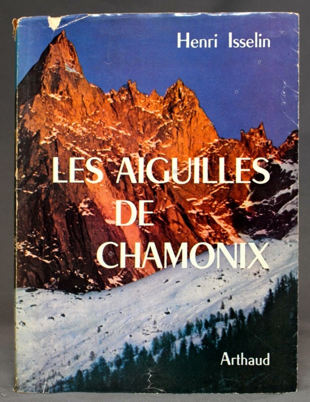
ISSELIN Henri:
Les Aiguilles de Chamonix.
Sans lieu, Arthaud, coll. Sempervivum 37, 1961. In-8 broché de 261-[11] pages, couverture imprimée sous jaquette photographique couleurs (avec 3 petits accrocs). Nom de possesseur.
Referência livreiro : 10673
|
|
|
Isserman Maurice and Stewart Weaver; maps and peak sketches Dee Molenaar
The Conquest of the Himalayas. A History of Himalayan Mountaineering from the Age of Empire to the Age of Extremes
<p>New Haven: Yale University Press 2008. first printing. Hardcover. Very Good/fine. xii 579p illustrations 26cm tall quarto. Rear board has light soil.</p> Yale University Press hardcover
Referência livreiro : 00004456 ISBN : 0300115016 9780300115017

|
|
|
ITALIE ILLUSTREE par P. JOUSSET.
L'Italie illustrée. 14 cartes et plans en couleurs, 9 cartes en noir, 12 planches hors texte, 784 photos.
Paris, éd. Larousse s.d. (vers 1920). Bon exemplaire relié, relieure demi cuir d'éd., fort in-4, 371 pages + planches.
Referência livreiro : AUB-4181
|
|
|
ITALY HISTORICAL MAPS Macpherson WW. mapmaker. Cooper engraver. W. W.
Italia in Regiones Undecim ab Augusto descripta cum Insulis Corsica et Sardinia; cura et studio D. Macpherson. SET OF FIVE MAPS.
London.: Longman Hurst Rees and Orme. 1805- 1807. SET OF FIVE black and white copperplate engraved maps centrefold as issued each approximately 10 x 15 3/4 inches on sheet size 10 1/2 x 16 inches. Paper loss to outer margins from insect damage mainly outside neat line light toning to paper mainly along centerfold and outer edges. Five maps include: "Italia in Regiones Undecim ab Augusto descripta cum Insulis Corsica et Sardinia" "Italia Media vet Italie Propriae pars Borealis ante divisionem ab Augusto factam" "Italia Ulterior cujus pars australis Magna Graecia ob Graecorum colonias dicta ante divisionem ab Augusto factam" "Sicilia Provincia Romanorum cum Insulis Adjacentibus" and "Italiae Regio Alpina quae vulgo sed minus recte dicitur Gallia Cisalpina". From Rees' Encyclopedia. . Longman, Hurst, Rees, and Orme. unknown
Referência livreiro : 44442

|
|
|
ITM Canada International Travel Maps Illustrator
Australia 1:3.5M Travel Map
ITMB Publishing Ltd 2010-12-30. 6. Map. Good. ITMB Publishing Ltd unknown
Referência livreiro : SONG1553411218 ISBN : 1553411218 9781553411215
|
|
|
ITM Canada International Travel Maps Editor
Sahara 1:3.85M Travel Map Travel Reference Map
Itmb Publishing Ltd 2006-08-01. 2. Map. Used:Good. Itmb Publishing, Ltd unknown
Referência livreiro : DADAX155341022X ISBN : 155341022X 9781553410225

|
|
|
ITM Canada; Editor International Travel Maps
Sahara 1:3.85M Travel Map Travel Reference Map
Itmb Publishing Ltd 2006-08-01. Map. Good. Itmb Publishing, Ltd unknown
Referência livreiro : SONG155341022X ISBN : 155341022X 9781553410225
|
|
|
ITMB International Travel Maps
Mekong Delta/Southern Vietnam Travel Reference Map: 1:500000
ITMB International Travel Maps 2007. Map. New. 2nd edition. 2 pages. 9.90x4.00x0.40 inches. ITMB International Travel Maps unknown
Referência livreiro : __1553415876 ISBN : 1553415876 9781553415879

|
|
|
ITMB International Travel Maps
Mekong Delta/Southern Vietnam Travel Reference Map: 1:500000
ITMB International Travel Maps 2007. Map. New. 2nd edition. 2 pages. 9.90x4.00x0.40 inches. ITMB International Travel Maps unknown
Referência livreiro : 2-1553415876 ISBN : 1553415876 9781553415879
|
|
|
ITMB Publishing International Travel Maps Editor
Jasper National Park Map by ITMB Travel Reference Map
ITMB Publishing 2000-01-01. 1. Map. Used:Good. ITMB Publishing unknown
Referência livreiro : DADAX1895907691 ISBN : 1895907691 9781895907698

|
|
|
Ivan T Sanderson text maps charts and illustrated by F Wenderoth Saunders
FOLLOW THE WHALE
Cassell & Co publishers London - first UK edition 1958 hardcover 5�" x 8�" with dust jacket Ours is an ex-library copy in transparent protective covering with usual stamps stickers barcode etc. GOOD book in GOOD price-clipped dust jacket Eleven major maps appendices 30-pages with Whaling Chronology Evolution of Whale Tails Comparative Sizes and illustrated list of Living Whales; plus Bibliography by Periods and Subjects; and Index. To follow the whale is to follow the whole course of one of the most important aspects of human history. It is virtually the story of the conquest of our planet Earth; a history in which man is almost anonymous. Here is the triumph of the puny and of the twilight of the mighty. Excellent history! Cassell & Co, publishers, London - first UK edition hardcover
Referência livreiro : 35025
|
|
|
Ivanoff Jacques Lejard Thiery
Mergui et les Limbes de L'archipel Oublie: Impressions observations et description de quelques îles au large du Ténasserim
White Lotus Co Ltd 2001 246 pages 20 8x2x29 2cm. 2001. Broché. 246 pages.
Referência livreiro : 500133231

|
|
|
J. & C. WALKER (Engraved by).
[MAP of TURKEY in EUROPE] Turkey I; Containing the Northern provinces. Published under the Superintendence of the Society for the diffusion of useful knowledge. Engraved by J. & C. Walker.
Very Good English Original map. Oblong folio. (36 x 43 cm). In English. [MAP of TURKEY in EUROPE] Turkey I; Containing the Northern provinces. Published under the Superintendence of the Society for the diffusion of useful knowledge. Engraved by J. & C. Walker. It shows Turkish / Ottoman provinces in Europe from Thrace to the southern borders of Hungary, Bessarabia and Transylvania at north, Adriatic shores at west, Black Sea coasts at east including Croatia, Hertsek, Zwornik, Semendri, Ieni Bazar, Krukhovatz, Widdin, Nikopoli, Wallachia, Sophia, Chirman, Kirkliseh, Wisa, Gallipoli, Ghiustendil, Skitari Ochrida, etc. A very detailed map.
|
|
|
J. & R. Baker Matson; Illustrator Maps b & w Photos
Mammals of Zacatecas Special Publications
Texas Tech University Press 1986-01-15. Hardcover. Good. Interior clean binding tight light wear to covers. No dust jacket. Texas Tech University Press hardcover
Referência livreiro : 0896721442isbn ISBN : 0896721442 9780896721449
|
|
|
J. & R. Baker Matson; Illustrator Maps b & w Photos
Mammals of Zacatecas Special Publications
Texas Tech University Press 1986-01-15. Hardcover. Very Good. Interior clean binding tight light wear to covers and dust jacket although dust jacket has a few slightly worn spots around the edges no chips or tears. Texas Tech University Press hardcover
Referência livreiro : 0896721442isbn2 ISBN : 0896721442 9780896721449
|
|
|
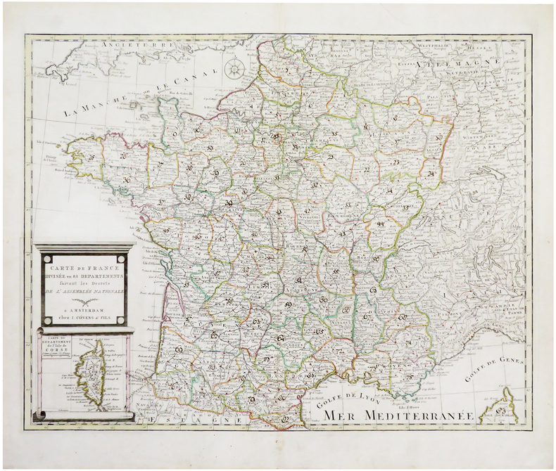
J. COVENS & FILS.
Carte de France divisée en 83 départements suivant les décrets de l'Assemblée Nationale.
Amsterdam, J. Covens & fils, [1791]. 478 x 613 mm.
Referência livreiro : LBW-6668
|
|
|
J. Craighead; Illustrator Maps Photos
A PROPOSED DELINEATION OF CRITICAL GRIZZLY BEAR HABITAT IN THE YELLOWSTONE REGION
Bear Biology Assoc 1980. Paperback. Very Good. Very good softcover book is clean and tight. 20pp Bear Biology Assoc paperback
Referência livreiro : 19474
|
|
|
J. Henry, maître de pension
CARTE DU DÉPARTEMENT : N° 1 - AIN, tirée de : ATLAS DE LA FRANCE, Nouvelle Géographie et statistique de la France, Alger et la Belgique, suivie d'un traité sur le monde entier : Ornée de 95 cartes et approuvée de l'Université , par J. Henry, maître de pension; 1842 [Chatellerault] : [J. Henry imprimeur-lithographe] Editeur,
Chatellerault J. Henry imprimeur-lithographe 1842 carte ancienne gravée en noir , cartouche illustré en noir. Lithographie recto-verso d'Alexandre Corbin, Format total : 40 centimètres de haut par 26,5 centimètres de large, 1842 [Chatellerault] : [J. Henry imprimeur-lithographe] Editeur,
Referência livreiro : 27474
|
|
|
J. Henry, maître de pension
CARTE DU DÉPARTEMENT : N° 11 - AVEYRON, tirée de : ATLAS DE LA FRANCE, Nouvelle Géographie et statistique de la France, Alger et la Belgique, suivie d'un traité sur le monde entier : Ornée de 95 cartes et approuvée de l'Université , par J. Henry, maître de pension; 1842 [Chatellerault] : [J. Henry imprimeur-lithographe] Editeur,
Chatellerault J. Henry imprimeur-lithographe 1842 carte ancienne gravée en noir , cartouche illustré en noir. Lithographie recto-verso d'Alexandre Corbin, Format total : 40 centimètres de haut par 26,5 centimètres de large, 1842 [Chatellerault] : [J. Henry imprimeur-lithographe] Editeur,
Referência livreiro : 27476
|
|
 Receber por correio electrónico
 Descarregar em documento PDF
 Fluxo RSS


