|
JOANNE (Adolphe)
Géographie de La Somme
Paris, Librairie Hachette, 1903, 68 pp. in-12, rel. carto. édit, dos toilé bleu, ill. h.t 11 grav. et une carte coloriée h.t dépl.
Référence libraire : 3797
|
|
|
JOANNE (Adolphe)
Géographie du Loiret
Paris, Librairie Hachette, 1903, 68 pp. in-12, rel. carto. édit, dos toilé bleu, ill. h.t 27 grav. et une carte coloriée h.t dépl.
Référence libraire : 3798
|
|
|
JOANNE (Adolphe)
Géographie du Tarn-et-Garonne
Paris, Librairie Hachette, 1885, 60 pp. in-12, rel. carto. édit, dos toilé bleu, ill. h.t 8 grav. et une carte coloriée h.t dépl.
Référence libraire : 3802
|
|
|
JOANNE (Adolphe)
Géographie de l'Oise
Paris, Librairie Hachette, 1902, 60 pp. in-12, rel. carto. édit, dos toilé bleu, ill. h.t 13 grav. et une carte coloriée h.t dépl.
Référence libraire : 3804
|
|
|
JOANNE (Adolphe)
Géographie du Nord
Paris, Librairie Hachette, 1904, 60 pp. in-12, rel. carto. édit, dos toilé bleu, ill. h.t 17 grav. et une carte coloriée h.t dépl.
Référence libraire : 3805
|
|
|
JOANNE (Adolphe)
Géographie de l'Allier
Paris, Librairie Hachette, 1908, 66 pp. in-12, rel. carto. édit, dos toilé bleu, ill. h.t 24 grav. et une carte coloriée h.t dépl.
Référence libraire : 3807
|
|
|
JOANNE (Adolphe)
Géographie du Maine-et-Loire
Paris, Librairie Hachette, 1908, 70 pp. in-12, rel. carto. édit, dos toilé bleu, ill. h.t 17 grav. et une carte coloriée h.t dépl.
Référence libraire : 3809
|
|
|
JOANNE (Adolphe)
Géographie des Hautes-Pyrénées
Paris, Librairie Hachette, 1897, 74 pp. in-12, rel. carto. édit, dos toilé bleu, ill. h.t 13 grav. et une carte coloriée h.t dépl.
Référence libraire : 3811
|
|
|
JOANNE (Adolphe)
Géographie du Puy-de-Dôme
Paris, Librairie Hachette, 1911, 82 pp. in-12, rel. carto. édit, dos toilé bleu, ill. h.t 21 grav. et une carte coloriée h.t dépl.
Référence libraire : 3813
|
|
|
JOANNE (Adolphe)
Géographie du Cantal
Paris, Librairie Hachette, 1895, 68 pp. in-12, rel. carto. édit, dos toilé bleu, ill. h.t 16 grav. et une carte coloriée h.t dépl.
Référence libraire : 3814
|
|
|
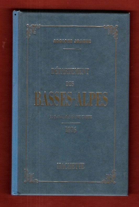
JOANNE Adolphe
Géographie Du Département Des Basses-Alpes . 11 Gravures & Une Carte Coloriée - 1876 . Complet De Sa Carte Dépliante En Couleurs
Paris Hachette 1993 In 12 Très belle iconographie reprenant les gravures des villages de l'époque . Guide Joanne . Cartes et plans . - 50 p. , 300 gr.
Référence libraire : 009987
|
|
|
JOANNE, Adolphe.
Géographie du département de la Nièvre. Avec une carte coloriée et 15 gravures. Neuvième édition.
Paris, Librairie Hachette 1907 183x113mm, 65pages, cartonnage de l’éditeur. Bel exemplaire.
Référence libraire : 63452
|
|
|
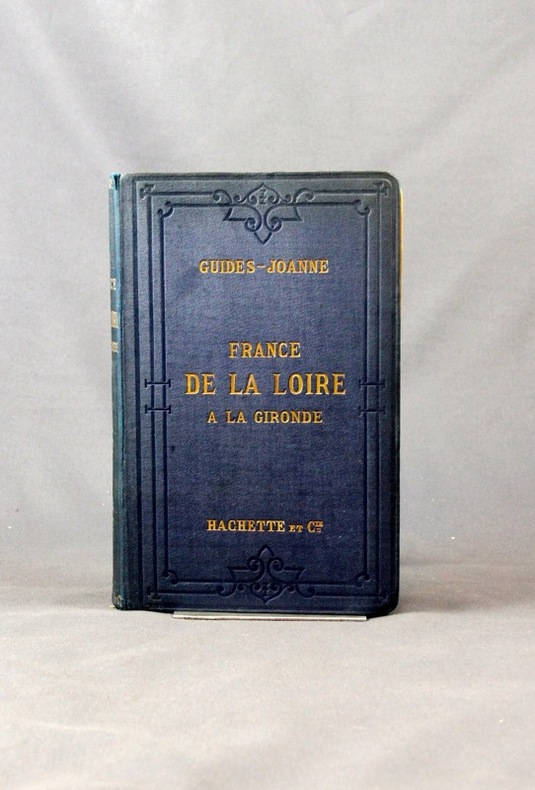
JOANNE Paul:
Itinéraire général de la France. (... ) De la Loire à la Gironde. Poitou et Saintonge.
Paris, Lib. Hachette et Cie, 1889. 1 vol. in-8 de 40, XXVI-259-126 pages, pleine percaline bleue d’éditeur, dos lisse orné à froid, plats encadrés à froid. Un mors fendu (1 cm), minuscules taches à la percaline, cahiers de publicité déboîtés mais solidaires.
Référence libraire : 2433
|
|
|
Joanne Paul
Itinéraire général de la France - Bretagne
Hachette et Cie Toile d'éditeur In-12 (11x17.5 cm), reliure toile d'éditeur, auteur, titre et éditeur dorés sur le 1er plat et au dos, 30-(XXXII)-662 pages et 92 pages de publicités des Guides Joanne, cartes dépliantes en couleurs ; ors un peu passés au dos, coiffes un peu frottées, une pastille ronde au dos, certaines pages se détachent du dos, assez bon état. Livraison a domicile (La Poste) ou en Mondial Relay sur simple demande.
Référence libraire : ys167
|
|
|
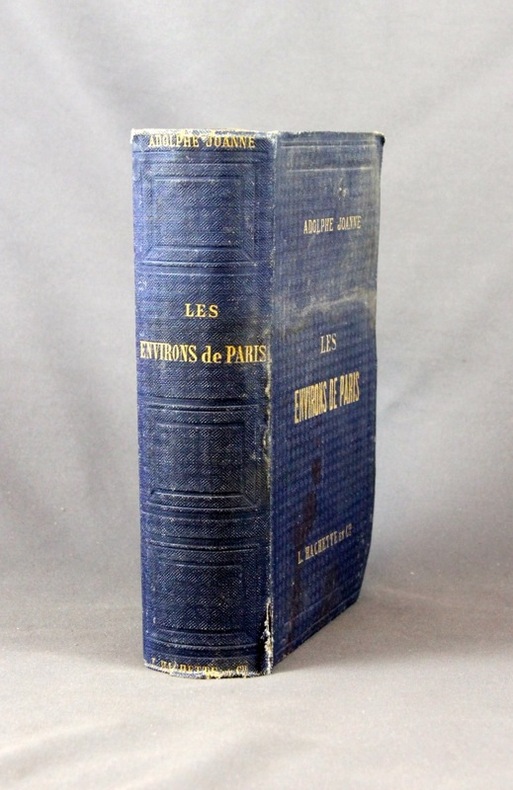
JOANNE Adolphe:
Les environs de Paris. Illustré. Itinéraire descriptif et historique.
Paris, Lib. de L. Hachette et Cie, [1856]. In-8 de XVI-847 pages, pleine percaline bleue d’éditeur, dos lisse orné de caissons à froid. Coiffes frottées, 1er plat taché, mors du 1er plat fendu en sa partie inférieure (3 cm), quelques rousseurs.
Référence libraire : 2432
|
|
|
JOANNE Ad.
Carte du d?partement de la Manche au 1/440 000?. Sans date.
1 feuille sous couverture toil?e d?fra?chie. 25x35 cm.
|
|
|
JOANNE Adolphe
Géographie Du Département Des Basses-Alpes . 11 Gravures & Une Carte Coloriée - 1876 . Complet De Sa Carte Dépliante En Couleurs
Très belle iconographie reprenant les gravures des villages de l'époque . Guide Joanne . Cartes et plans . - 50 p. , 300 gr.

|
|
|
JOANNE Adolphe
Nouveau plan de Paris
- Hachette, Paris 1867, 11x17,8cm, relié. - Collection des guides Joanne. Liste alphabétique des rues de Paris avec également la liste des omnibus et leurs trajets, les prix, les voitures mobiles et autres transports publics. Reliure d'éditeur en pleine percaline violette. Dos lisse muet. Titre et armes de Paris sur le premier plat. Grand plan dépliante de Paris en couleurs. Plusieurs petites déchirures. Bon exemplaire. Le Paris de Napoléon III et de Haussman. Ce plan de Paris a été édité pour l'exposition universelle de Paris de 1867. On lit à la fin du capitre sur les voitures publiques : "Un service spécial, de la place du Palais-Royal au pot d'Iena, aura lieu pendant toute la durée de l'exposition". [ENGLISH DESCRIPTION ON DEMAND]

|
|
|
JOANNE Paul
Belgique et Grand-Duché De Luxembourg . Complet De Sa Carte Indépendante En Fin D'ouvrage
Collection " Des Guides-Joanne " avec 15 plans et 7 cartes en couleurs dont certaines dépliantes . Nombreuses publicités , notamment d'hôtels mais aussi de Michelin , de chocolat Menier etc .- 312 p. + 118 p. , 550 gr.

|
|
|
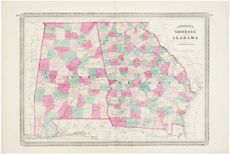
JOHNSON (Alvin Jewett).
Georgia and Alabama.
New York ,1863. 388 x 561 mm.
Référence libraire : LBW03586
|
|
|
JOHANNE (Adolphe)
Géographie des Basses-Pyrénées
Paris, Librairie Hachette, 1894, 76 pp. in-12, rel. carto. édit, dos toilé bleu, ill. h.t 12 grav. et une carte coloriée h.t dépl.
Référence libraire : 3799
|
|
|
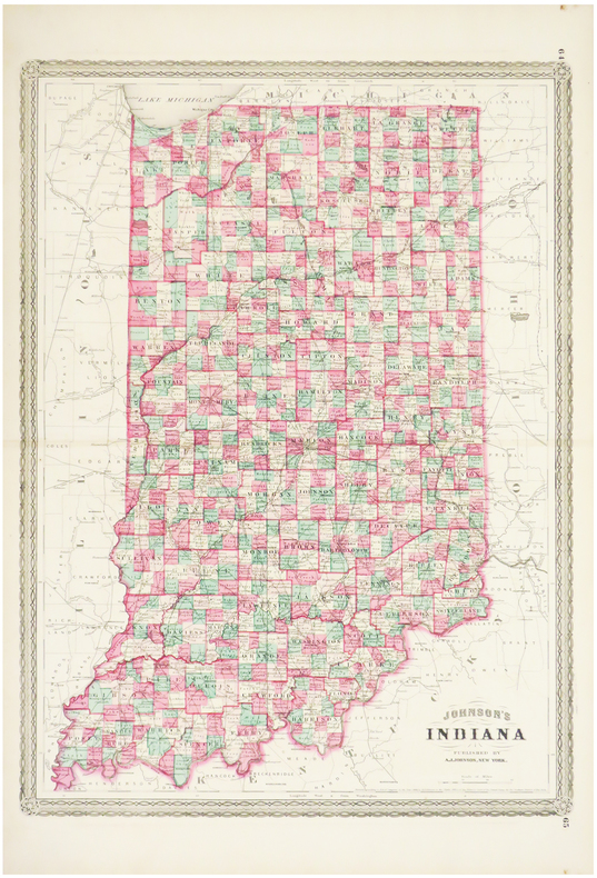
JOHNSON (Alvin Jewett).
Indiana.
New York, 1864. 585 x 435 mm.
Référence libraire : LBW03585
|
|
|
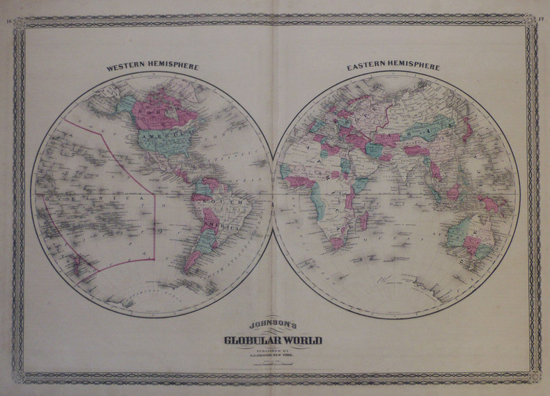
JOHNSON (Alvin Jewett);
Johnson's globular world.
New York A.J. Johnson 1870 408 x 585 mm.
Référence libraire : LBW-1258
|
|
|
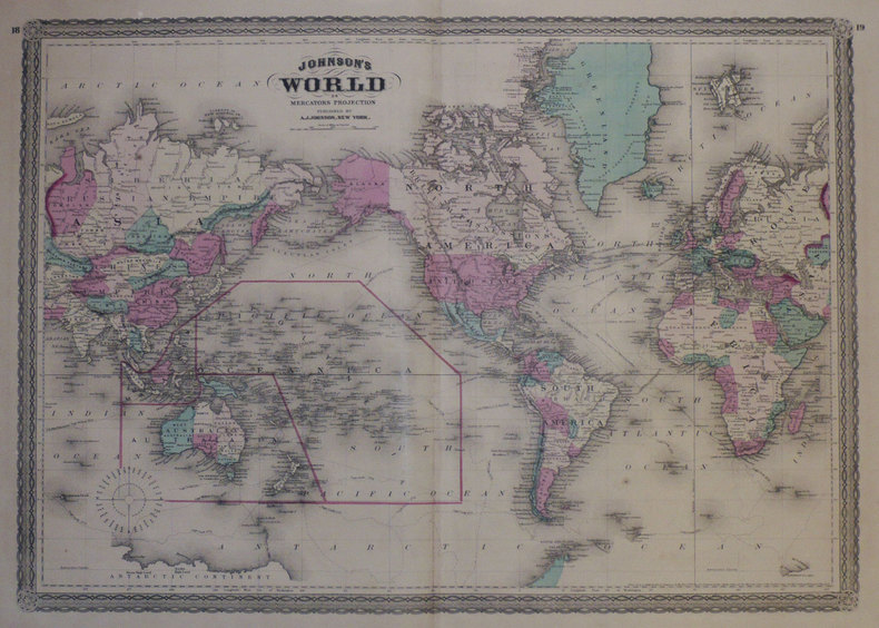
JOHNSON (Alvin Jewett);
Johnson's World on Mercator's projection.
New York A.J. Johnson 1870 412 x 585 mm.
Référence libraire : LBW-1259
|
|
|
JOHNSON (Alvin Jewett);
Johnson's United States.
New York A.J. Johnson 1870 422 x 582 mm.
Référence libraire : LBW-1260

|
|
|
JOHNSON (Alvin Jewett);
Johnson's Washington and Georgetown.
New York A.J. Johnson 1870 323 x 422 mm.
Référence libraire : LBW-1261

|
|
|
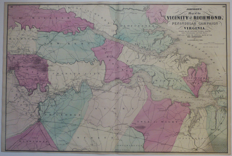
JOHNSON (Alvin Jewett);
Johnson's Map of the vicinity of Richmond, and peninsular campaign in Virginia.
New York A.J. Johnson 1870 446 x 671 mm.
Référence libraire : LBW-1264
|
|
|
JOHNSON (Alvin Jewett);
Johnson's Florida.
New York A.J. Johnson 1870 300 x 377 mm.
Référence libraire : LBW-1265

|
|
|
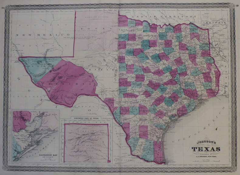
JOHNSON (Alvin Jewett);
Johnson's Texas.
New York A.J. Johnson 1870 423 x 585 mm.
Référence libraire : LBW-1266
|
|
|
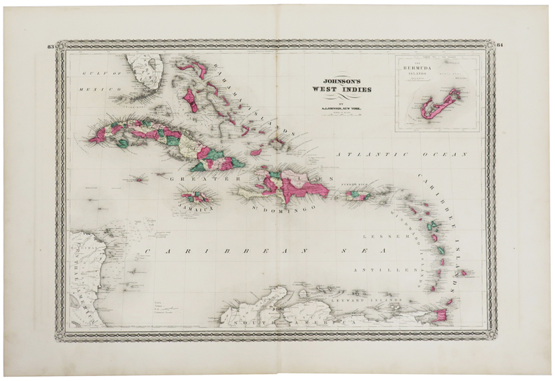
JOHNSON (Alvin Jewett).
Johnson's West Indies.
New York, A.J. Johnson, 1870. 376 x 543 mm.
Référence libraire : LBW-1269
|
|
|
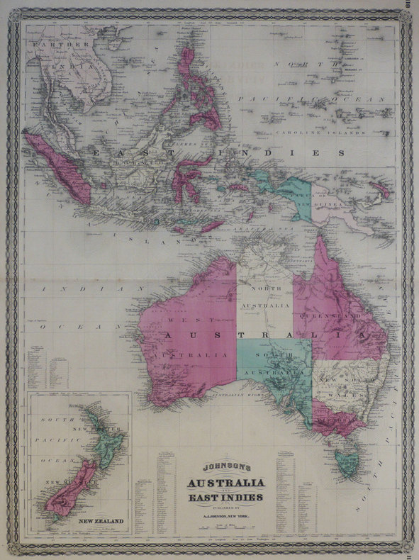
JOHNSON (Alvin Jewett);
Johnson's Australia and East Indies.
New York A.J. Johnson 1870 580 x 430 mm.
Référence libraire : LBW-1273
|
|
|
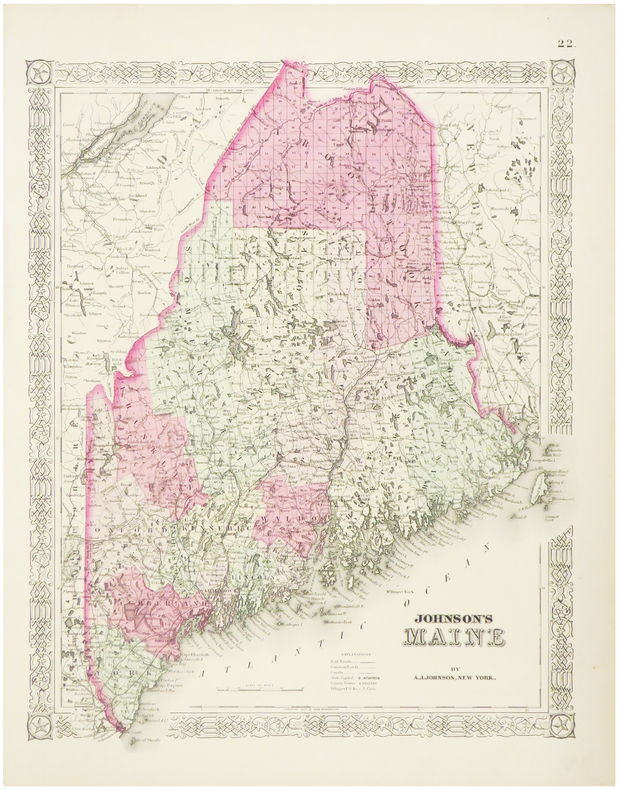
JOHNSON (Alvin Jewett).
Maine.
New York, 1864. 405 x 325 mm.
Référence libraire : LBW03582
|
|
|
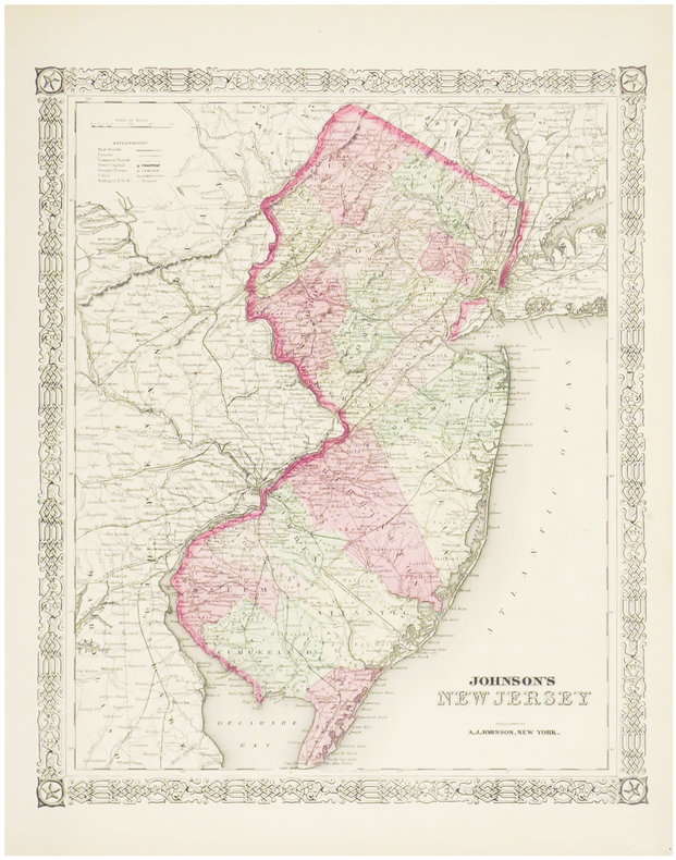
JOHNSON (Alvin Jewett).
New Jersey.
New York, 1864. 395 x 325 mm.
Référence libraire : LBW03581
|
|
|
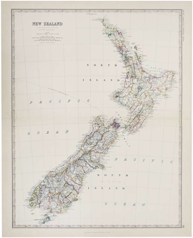
JOHNSTON (W. & A.K.).
New Zealand.
Edinburgh, 1884. 571 x 441 mm.
Référence libraire : LBW-509
|
|
|
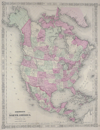
JOHNSON (Alvin Jewett);
North America.
New York 1864 564 x 435 mm.
Référence libraire : LBW0357d
|
|
|
JOHNSON (Alvin Jewett).
Pennsylvania and New Jersey.
New York, 1864. 435 x 601 mm.
Référence libraire : LBW03584

|
|
|
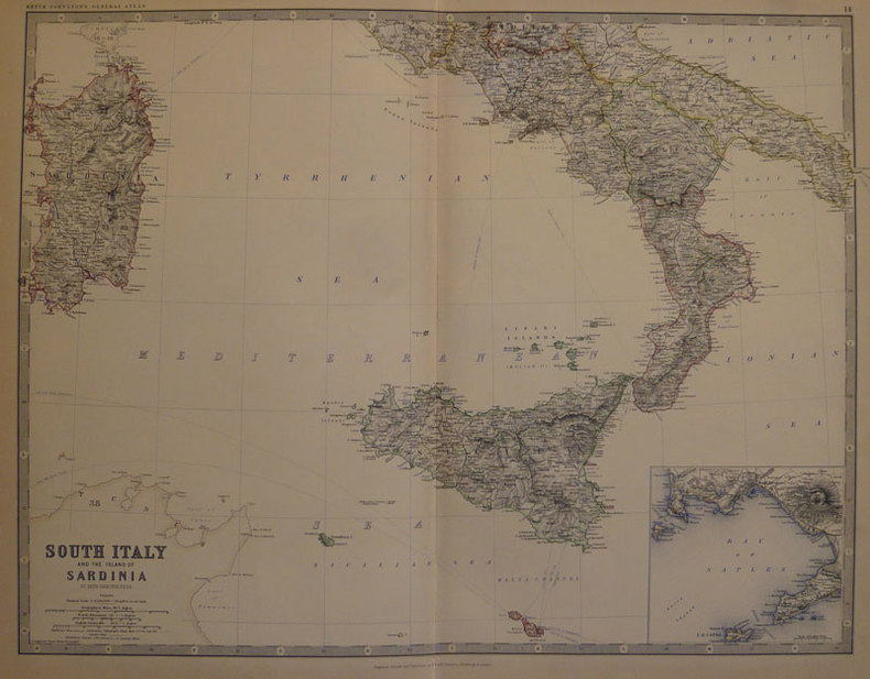
JOHNSTON (Keith);
South Italy and the island of Sardinia.
Edinburgh W. & A.K. Johnston 1884 450 x 573 mm.
Référence libraire : LBW-501
|
|
|
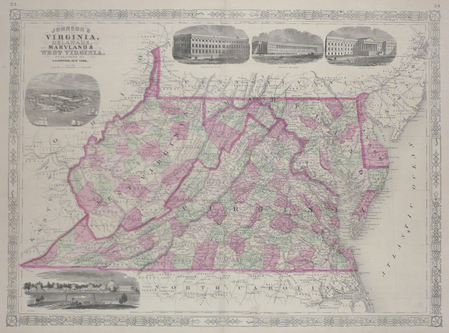
JOHNSON (Alvin Jewett);
Virginia, Delaware, Maryland & West Virginia.
New York 1864 430 x 587 mm.
Référence libraire : LBW03583
|
|
|
John Anderson and Stearns Morse Illustrated by Black and White Photos maps
The Book of the White Mountians
New York: Minton Balch & Company 1930 1930 Green Cloth Gilt Titles. No Jacket. First. 300 pages. New York: Minton, Balch & Company, 1930 hardcover
Référence libraire : 002520
|
|
|
John Anthony Caruso Francis J. Mitchell maps
The Great Lakes Frontier: A Epic of the Old Northwest
The Bobbs-Merrill Company Inc. Used - Good. Former Library book. Shows some signs of wear and may have some markings on the inside. The Bobbs-Merrill Company, Inc unknown
Référence libraire : GRP79211165
|
|
|
John Bartholomew & Son Ltd Maps prepared by & printed by
Atlas of the World Franklin Library Special Edition prepared for The Royal Geographical Society of Times Atlas of the World
John Bartholomew & Son Ltd Maps prepared by & printed by Franklin Library nd c1987 Special Edition prepared for The Royal Geographical Society Times Atlas of the World Limited to 7500 copies full gilt decorated leather w/ribbed spine & gilt spine titles aeg silk end papers about fine no dj 228 pp w/index color map illus. folio $125.00 hardcover
Référence libraire : 332189
|
|
|
John Bartholomew
Map of Spain and Portugal in Layer Colouring 1 : 1,600,000. (1943)
Clean map with two panes a little dusty, four inch tear along one fold and small holes to a few folding corners. 1pp. Linen-backed folded contour map dated 1943 opens up to 25 x 31 inches. Scale given on front cover of 1:6,000,000 is corrected inside as being 1:1,600.000. Date 1943 printed on lower map corner. Scarce.
|
|
|
John Betjeman
John Betjeman's Oxford
No marks or inscriptions. No creasing to covers or to spine. A very clean very tight copy with bright unmarked boards, slight sunning to spine, signs of storage and no bumping to corners. 192pp. Originally written in the 1930s, an unusual illustrated guide and history to the City of Oxford.

|
|
|
John Brick; Illustrator Maps on End Papers
Jubilee: A Novel About Sherman's Army
Doubleday & Co 1956-01-01. Hardcover. Very Good. Nice looking book has minor edge wear. Doubleday & Co hardcover
Référence libraire : 1007300040
|
|
|
John Daly RN BA MEdHons BHScN PhD MACE AFACHSE FCN FRCNA; Sandra Speedy RN BAHons DipEd MURP EdN MAPS FANZCMHN; De
Contexts of Nursing: An Introduction
Churchill Livingstone 2005-10-18. Paperback. Good. Churchill Livingstone paperback
Référence libraire : SONG0729537463 ISBN : 0729537463 9780729537469

|
|
|
John Daly RN BA MEdHons BHScN PhD MACE AFACHSE FCN FRCNA; Sandra Speedy RN BAHons DipEd MURP EdN MAPS FANZCMHN; De
Contexts of Nursing
Churchill Livingstone 2009-10-16. Paperback. Good. Churchill Livingstone paperback
Référence libraire : SONG0729539253 ISBN : 0729539253 9780729539258
|
|
|
John Daly RN BA MEdHons BHScN PhD MACE AFACHSE FCN FRCNA Sandra Speedy RN BAHons DipEd MURP EdN MAPS FANZCMHN De
Nursing Leadership 1e
Churchill Livingstone 2003-11-15. Paperback. Used:Good. Churchill Livingstone paperback
Référence libraire : DADAX0729537412 ISBN : 0729537412 9780729537414
|
|
|
John Daly RN BA MEdHons BHScN PhD MACE AFACHSE FCN FRCNA; Sandra Speedy RN BAHons DipEd MURP EdN MAPS FANZCMHN; De
Nursing Leadership
Churchill Livingstone 2003-11-01. Paperback. Good. Churchill Livingstone paperback
Référence libraire : SONG0729537412 ISBN : 0729537412 9780729537414
|
|
|
John de Visser
Grand River Reflections
No marks or inscriptions. A lovely clean very tight copy with bright unmarked boards, very slight bumping to lower edge and no bumping to corners. Dust jacket not price clipped or marked or torn or creased. 155pp. A lavish photographic work giving some details of the history of the area from the Dundalk Highlands of Southern Ontario to Port Maitland on Lake Erie, beautifully enhanced by the superb colour images.. Very scarce in the UK.

|
|
|
John editor in chief; Bacheller Martin A. editor in chief for maps Denson
The Five Worlds of Our Lives: Ingredients and Results of War and Revolution
Newsweek Inc. and C.S. Hammond and Co. Inc. LEATHER BOUND. B0019W0M10 1961 Over sized leather bound volume. Text is clean binding is good covers have wear. . Good. Newsweek, Inc. and C.S. Hammond and Co., Inc. hardcover
Référence libraire : SKU1004812
|
|
 Recevoir par e-mail
 Télécharger en PDF
 Flux RSS


