|
Bonne Rigobert
3 Sheet Map Middle East Western Asia India: Imperia Antiqua pars Orientalis pars Media pars Occidentalis
Paris: Hotel De Thou Rue Des Poitevins 1787. Near fine three-sheet map set copperplate engravings b&w as issued each image measuring approximately 23 x 33 cm. Engraved by Gaspar Andr�. These are sheets 5 6 and 7 from Bonne and Desmarest's "Atlas Encyclpedique." Several wind diagrams present. The eastern sheet shows India and "Taprobana" Island. The western sheet shows portions of northeastern Africa. . Hotel De Thou, Rue Des Poitevins unknown
Bookseller reference : 3629
|
|
|
Bonne Rigobert
Atlas encyclopedique : contenant la géographie ancienne et quelques cartes sur la géographie du moyen age la geographie moderne et les cartes relatives a la géographie physique / par M. Bonne . et par M. Desmarest . T. 2. Volume T. 2. 1788 Leather Bound
2019. Leather Bound. New. Leather Binding on Spine and Corners with Golden Leaf Printing on round Spine. Reprinted in 2019 with the help of original edition published long back 1788. This book is printed in black & white sewing binding for longer life Printed on high quality Paper re-sized as per Current standards professionally processed without changing its contents. As these are old books we processed each page manually and make them readable but in some cases some pages which are blur or missing or black spots. We expect that you will understand our compulsion in these books. We found this book important for the readers who want to know more about our old treasure so we brought it back to the shelves. Hope you will like it and give your comments and suggestions. Lang: - spa Vol: - Volume T. 2. Pages 382. EXTRA 10 DAYS APART FROM THE NORMAL SHIPPING PERIOD WILL BE REQUIRED FOR LEATHER BOUND BOOKS. FOLIO EDITION IS ALSO AVAILABLE. Volume T. 2. hardcover
Bookseller reference : LB1111009757936
|
|
|
Bonne Rigobert
Atlas encyclopedique : contenant la géographie ancienne et quelques cartes sur la géographie du moyen age la geographie moderne et les cartes relatives a la géographie physique / par M. Bonne . et par M. Desmarest . T. 1. Volume T. 1. 1788 Leather Bound
2019. Leather Bound. New. Leather Binding on Spine and Corners with Golden Leaf Printing on round Spine. Reprinted in 2019 with the help of original edition published long back 1788. This book is printed in black & white sewing binding for longer life Printed on high quality Paper re-sized as per Current standards professionally processed without changing its contents. As these are old books we processed each page manually and make them readable but in some cases some pages which are blur or missing or black spots. We expect that you will understand our compulsion in these books. We found this book important for the readers who want to know more about our old treasure so we brought it back to the shelves. Hope you will like it and give your comments and suggestions. Lang: - spa Vol: - Volume T. 1. Pages 316. EXTRA 10 DAYS APART FROM THE NORMAL SHIPPING PERIOD WILL BE REQUIRED FOR LEATHER BOUND BOOKS. FOLIO EDITION IS ALSO AVAILABLE. Volume T. 1. hardcover
Bookseller reference : LB1111009757937
|
|
|
Bonne Rigobert
Atlas encyclop�dique contenant la g�ographie ancienne et quelques cartes sur la g�ographie du moyen �ge la g�ographie moderne et les cartes relatives � la g�ographie physique / par M. Bonne . et par M. Desmarest . 1787
2020. Paperback. New. Lang: - fre Pages 475. Reprinted in 2020 with the help of original edition published long back 1787. This book is Printed in black & white sewing binding for longer life with Matt laminated multi-Colour Soft Cover HARDCOVER EDITION IS ALSO AVAILABLE Printed on high quality Paper re-sized as per Current standards professionally processed without changing its contents. As these are old books we processed each page manually and make them readable but in some cases some pages which are blur or missing or black spots. If it is multi volume set then it is only single volume if you wish to order a specific or all the volumes you may contact us. We expect that you will understand our compulsion in these books. We found this book important for the readers who want to know more about our old treasure so we brought it back to the shelves. Any type of Customisation is possible with extra charges. Hope you will like it and give your comments and suggestions. paperback
Bookseller reference : PB1111009757939
|
|
|
Bonne Rigobert
Atlas encyclop�dique contenant la g�ographie ancienne et quelques cartes sur la g�ographie du moyen �ge la g�ographie moderne et les cartes relatives � la g�ographie physique / par M. Bonne . et par M. Desmarest . 1787
2020. Paperback. New. Lang: - fre Pages 393. Reprinted in 2020 with the help of original edition published long back 1787. This book is Printed in black & white sewing binding for longer life with Matt laminated multi-Colour Soft Cover HARDCOVER EDITION IS ALSO AVAILABLE Printed on high quality Paper re-sized as per Current standards professionally processed without changing its contents. As these are old books we processed each page manually and make them readable but in some cases some pages which are blur or missing or black spots. If it is multi volume set then it is only single volume if you wish to order a specific or all the volumes you may contact us. We expect that you will understand our compulsion in these books. We found this book important for the readers who want to know more about our old treasure so we brought it back to the shelves. Any type of Customisation is possible with extra charges. Hope you will like it and give your comments and suggestions. paperback
Bookseller reference : PB1111009757938
|
|
|
Bonne Rigobert
Atlas encyclop�dique contenant la g�ographie ancienne et quelques cartes sur la g�ographie du moyen �ge la g�ographie moderne et les cartes relatives � la g�ographie physique / par M. Bonne . et par M. Desmarest . 1787 Hardcover
2020. Hardcover. New. Lang: - fre Pages 393. Reprinted in 2020 with the help of original edition published long back 1787. This book is Printed in black & white Hardcover sewing binding for longer life with Matt laminated multi-Colour Dust Cover Printed on high quality Paper re-sized as per Current standards professionally processed without changing its contents. As these are old books we processed each page manually and make them readable but in some cases some pages which are blur or missing or black spots. If it is multi volume set then it is only single volume if you wish to order a specific or all the volumes you may contact us. We expect that you will understand our compulsion in these books. We found this book important for the readers who want to know more about our old treasure so we brought it back to the shelves. Any type of Customisation is possible with extra charges. Hope you will like it and give your comments and suggestions. hardcover
Bookseller reference : 1111009757938
|
|
|
Bonne Rigobert
Atlas encyclop�dique contenant la g�ographie ancienne et quelques cartes sur la g�ographie du moyen �ge la g�ographie moderne et les cartes relatives � la g�ographie physique / par M. Bonne . et par M. Desmarest . 1787 Hardcover
2020. Hardcover. New. Lang: - fre Pages 475. Reprinted in 2020 with the help of original edition published long back 1787. This book is Printed in black & white Hardcover sewing binding for longer life with Matt laminated multi-Colour Dust Cover Printed on high quality Paper re-sized as per Current standards professionally processed without changing its contents. As these are old books we processed each page manually and make them readable but in some cases some pages which are blur or missing or black spots. If it is multi volume set then it is only single volume if you wish to order a specific or all the volumes you may contact us. We expect that you will understand our compulsion in these books. We found this book important for the readers who want to know more about our old treasure so we brought it back to the shelves. Any type of Customisation is possible with extra charges. Hope you will like it and give your comments and suggestions. hardcover
Bookseller reference : 1111009757939
|
|
|
Bonne Rigobert
Atlas encyclopedique : contenant la g�ographie ancienne et quelques cartes sur la g�ographie du moyen age la geographie moderne et les cartes relatives a la g�ographie physique / par M. Bonne . et par M. Desmarest . T. 2. Volume T. 2. 1788
2020. Paperback. New. Lang: - spa Vol: - Volume T. 2. Pages 382. Reprinted in 2020 with the help of original edition published long back 1788. This book is Printed in black & white sewing binding for longer life with Matt laminated multi-Colour Soft Cover HARDCOVER EDITION IS ALSO AVAILABLE Printed on high quality Paper re-sized as per Current standards professionally processed without changing its contents. As these are old books we processed each page manually and make them readable but in some cases some pages which are blur or missing or black spots. We expect that you will understand our compulsion in these books. We found this book important for the readers who want to know more about our old treasure so we brought it back to the shelves. Any type of Customisation is possible with extra charges. Hope you will like it and give your comments and suggestions. Volume T. 2. paperback
Bookseller reference : PB1111009757936
|
|
|
Bonne Rigobert
Atlas encyclopedique : contenant la g�ographie ancienne et quelques cartes sur la g�ographie du moyen age la geographie moderne et les cartes relatives a la g�ographie physique / par M. Bonne . et par M. Desmarest . T. 1. Volume T. 1. 1788
2020. Paperback. New. Lang: - spa Vol: - Volume T. 1. Pages 316. Reprinted in 2020 with the help of original edition published long back 1788. This book is Printed in black & white sewing binding for longer life with Matt laminated multi-Colour Soft Cover HARDCOVER EDITION IS ALSO AVAILABLE Printed on high quality Paper re-sized as per Current standards professionally processed without changing its contents. As these are old books we processed each page manually and make them readable but in some cases some pages which are blur or missing or black spots. We expect that you will understand our compulsion in these books. We found this book important for the readers who want to know more about our old treasure so we brought it back to the shelves. Any type of Customisation is possible with extra charges. Hope you will like it and give your comments and suggestions. Volume T. 1. paperback
Bookseller reference : PB1111009757937
|
|
|
Bonne Rigobert
Atlas portatif g�n�ral pour servir � l'intelligence des auteurs classiques par M. l'abb� Grenet. 1800
2020. Paperback. New. Lang: - fre Pages 388. Reprinted in 2020 with the help of original edition published long back 1800. This book is Printed in black & white sewing binding for longer life with Matt laminated multi-Colour Soft Cover HARDCOVER EDITION IS ALSO AVAILABLE Printed on high quality Paper re-sized as per Current standards professionally processed without changing its contents. As these are old books we processed each page manually and make them readable but in some cases some pages which are blur or missing or black spots. If it is multi volume set then it is only single volume if you wish to order a specific or all the volumes you may contact us. We expect that you will understand our compulsion in these books. We found this book important for the readers who want to know more about our old treasure so we brought it back to the shelves. Any type of Customisation is possible with extra charges. Hope you will like it and give your comments and suggestions. paperback
Bookseller reference : PB1111009758023
|
|
|
Bonne Rigobert
Atlas portatif g�n�ral pour servir � l'intelligence des auteurs classiques par M. l'abb� Grenet. 1800 Hardcover
2020. Hardcover. New. Lang: - fre Pages 388. Reprinted in 2020 with the help of original edition published long back 1800. This book is Printed in black & white Hardcover sewing binding for longer life with Matt laminated multi-Colour Dust Cover Printed on high quality Paper re-sized as per Current standards professionally processed without changing its contents. As these are old books we processed each page manually and make them readable but in some cases some pages which are blur or missing or black spots. If it is multi volume set then it is only single volume if you wish to order a specific or all the volumes you may contact us. We expect that you will understand our compulsion in these books. We found this book important for the readers who want to know more about our old treasure so we brought it back to the shelves. Any type of Customisation is possible with extra charges. Hope you will like it and give your comments and suggestions. hardcover
Bookseller reference : 1111009758023
|
|
|
BONNE Rigobert.
Carte gravée figurant : La Turquie d'Europe et celle d'Asie hors la partie située dans l'Arabie.
Paris s.é. circa 1774. Dimensions marges comprises : 341 x 268 mm. Jolie carte gravée à l'eau-forte figurant l'empire ottoman extraite de l'Atlas de Raynal de l'ouvrage Histoire philosophique et politique des établissements et du commerce des Européens dans les deux Indes. La carte laisse apparaître une partie de l'Italie de la Hongrie ainsi que de l'Autriche. La Grèce la Turquie la Géorgie le Kurdistan l'Arménie la Jordanie Israël la Palestine l'Iran l'Irak et la Syrie figurent ici en entier. Plissure centrale. Discrètes rousseurs. Du reste belle condition. [Paris], s.é., [circa 1774]. Dimensions (marges comprises) : 341 x 268 mm. unknown
Bookseller reference : 11627
|
|
|
Bonne Rigobert
Map of Italy: Italie
Paris: Hotel De Thou Rue Des Poitevins 1787. Near fine map of Italy from Bonne and Desmarest's "Atlas Encylopedique." Engraved by Gaspar Andr�. Prime meridians are Paris and the Isle de Fer. Nine separate scales. B&W as issued. This is plate 51 from the atlas. The copperplate engraved image measures 33 x 23 cm. Sicily Sardinia and Corsica are shown. Hotel De Thou, Rue Des Poitevins unknown
Bookseller reference : 3625
|
|
|
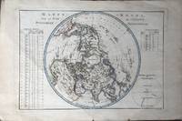
Bonne Rigobert
Map of Northern Hemisphere: Mappe - Monde sur le Plan de L'Equateur Hemisphere Septentrional
Paris: Hotel De Thou Rue Des Poitevins 1787. Very good copperplate engraved map b&w as issued with some generalized browning. Engraved by Gaspar Andr�. Several tables with climactic information present and a spherical represenation of climactic zones in the lower right corner. This is plate 22 from the "Atlas Encyclopedique." by Bonne and Desmarest. The image measures approximately 23 X 33 cm. Hotel De Thou, Rue Des Poitevins unknown
Bookseller reference : 3627
|
|
|
Bonne Rigobert
Map of Spain and Portugal: Le Royaume D'Espagne et celui de Portugal
Paris: Hotel De Thou Rue Des Poitevins 1787. Near fine copperplate engraved map b&w as issued. Engraved by Gaspar Andr�. From Bonne and Desmarest's 1787 "Atlas Encyclopedique." This is plate 44 from the atlas. Seven separate scales. Prime meridians Paris and Isle de Fer. The image measures 23 x 33 cm. Hotel De Thou, Rue Des Poitevins unknown
Bookseller reference : 3626
|
|
|
Bonne Rigobert
Mappe-Monde Sur Le Plan De L'Equateur Hemisphere Septentrional.
Paris 1787. Engraved map on laid paper sheet size is 44cm x 29cm. 17 x 11.5 inches. Contemporary colouring in outline. Small chip to lower margin at fold a nice clean copy. At lower right: "Andre sculp". At upper right: "22". Bonne's map of the Northern Hemisphere published in Atlas Encyclop�dique . 1787. <br/><br/> Paris, 1787. unknown
Bookseller reference : 55720
|
|
|
Bonne Rigobert
Two Map Set: Roman Empire east and west sheets: Imperii Romani Distracta pars Orientalis and pars Occidentalis
Paris: Hotel De Thou Rue Des Poitevins 1787. Near fine two sheet copperplate engraved set plates 18 and 19 b&w as issued from the "Atlas Encyclopedique." by Bonne and Desmarest. Engraved by Gaspar Andr�. A nice wind rose is present on the lower left of sheet 18 the western sheet. Each image measures approximately 23 x 33 cm. Hotel De Thou, Rue Des Poitevins unknown
Bookseller reference : 3628
|
|
|
BONNE Rigobert
Carte des Isles de la Guadeloupe, de Marie Galante, de la Désirade, et celles des Saintes
S.n. s.d. (1780), 42,3x27,5cm, une carte.
Bookseller reference : 79093
|
|
|
BONNE Rigobert,Vaugondy,
ATLAS MODERNE - seconde partie contenant les cartes de détails qui manquent à la premiére et qui rendent cet atlas complet, par plusieurs auteurs
1771 1771 P.LATTRE , DELALAIN s .d .( 1771) Edition originale in folio 1/2 veau , tranches rouges, titre gravé, 2 pages imprimées de texte de présentation et 41 cartes aux contours coloriés (50x80 cm), coloris de l'époque ,à double page gravées par Lattré , d'aprés Bonne, Zannoni etc, 13 cartes des provinces de France et 28 cartes d'Europe ,d' Amérique, d' Afrique, d' Asie ,liste détaillée sur demande
Bookseller reference : 2483
|
|
|
BONNE Rigobert:
Petit tableau de la France, ou Cartes géographiques sur toutes les parties de ce royaume. [suivi de] Description géographique abrégée de la France.
Paris, Lattré; Buttard, 1764. 2 tomes en un volume in-12 de [8]-213-[1]-10 pages, plein maroquin cerise, dos lisse orné de fleurons et de petits fers dorés, pièces de titre insolée, triple filet doré et écoinçons en encadrement des plats, filet doré aux coupes, roulette dorée aux chasses, tranches dorées.
Bookseller reference : 16474
|
|
 Receive by email
 Download as PDF document
 RSS feed