|
|
|
MAIRE N.
CARTE D'ITALIE DIVISEE EN SES DIVERS ETATS.
Avec les plans des principales villes, par N. Maire, Ing. du Roi. 1820. Bella carta geografica dell'Italia (mm. 632x1000), incisa da Perrier e B. Tardieu, montata su tela e suddivisa in 44 parti. Ai lati figurano 6 piante delle capitali degli Stati che componevano l'Italia e precisamente: Rome (Etats du Saint-Sige) - Naples (Royaume des Deux-Siciles) - Milan (Royaume Lombard-Vnitien) - Florence (Grand duch de Toscane) - Venise (2.me capitale du Royaume Lombard-Vnitien) - Turin (Royaume de Sardaigne). Su ogni pianta di citt sono riportati principaux difices et notices historiques. La carta, ripiegata, inserita in un astuccio in cartonato stile Ottocento (mm. 165x98) ed ben conservata.
Référence libraire : 116611
|
|
|
MAITRE LEON
Dictionnaire topographique de la France comprenant les noms de lieu anciens et modernes : Mayenne.
Paris. Imprimerie Nationale. 1878, 353 p. 28 cm.
Référence libraire : 5729
|
|
|
Main Administration of Geodesy and Cartography
Moscow: Plan of the Passenger Transport
USSR. Used - Good. Good condition. Includes booklet and map in sleeve. tranportation routes travel guide USSR unknown
Référence libraire : SB08C-01359
|
|
|
MAIR (John)
A Brief Survey of the Terraqueous Globe: Containing I. The Description and Use of the Globes. II. The Construction and Use of Maps. III. Geography; Or, a Short View of the Antient and Modern State of the Several Kingdom of the World...
Second edition, 12mo (173 x 105 mm), viii, 350pp., with half-title, 2 folding hand-coloured maps, a couple of gatherings sprung, small spot stain to prelims, cont. calf, a little rubbed, head and foot of spine worn, red morocco spine label. Provenance: Ownership signature to front endpaper 'Matilda Farquhaison 1782.' Scarce, ESTC returns just 3 locations (British Library, National Library of Scotland and University of Minnesota.
|
|
|
MAIRE N.
CARTE D’ITALIE DIVISEE EN SES DIVERS ETATS. Avec les plans des principales villes, par N. Maire, Ing. du Roi.
Bella carta geografica dell’Italia (mm. 632x1000), incisa da Perrier e B. Tardieu, montata su tela e suddivisa in 44 parti. Ai lati figurano 6 piante delle capitali degli Stati che componevano l’Italia e precisamente: Rome (Etats du Saint-Siège) - Naples (Royaume des Deux-Siciles) - Milan (Royaume Lombard-Vénitien) - Florence (Grand duché de Toscane) - Venise (2.me capitale du Royaume Lombard-Vénitien) - Turin (Royaume de Sardaigne). Su ogni pianta di città sono riportati “principaux édifices et notices historiques”. La carta, ripiegata, è inserita in un astuccio in cartonato stile Ottocento (mm. 165x98) ed è ben conservata.

|
|
|
Majer Paesler Ruppert Schaffer
GEOGRAFIA SOCIALE.
(Codice SY/0849) In 8° 224 pp. Brossura editoriale. Margini ingialliti, ottimo stato. ~~~ SPEDIZIONE IN ITALIA SEMPRE TRACCIATA

|
|
|
MALTE-BRUN (V.)
Atlas de la France illustrée
Paris, J. Rouff, Editeur, s.d. (fin XIXe s.) Nouvelle édition. In-4 relié demi-basane verte, dos à nerfs, format à l'italienne. Gravé par Erhard. Cartes en couleurs : 95 planches + Supplément 4 planches. Bon état : la 2e planche (carte de France) est entière mais déchirée. Rousseurs sur pages de garde. Couverture : cuir et coins usés.
Référence libraire : 7850
|
|
|
MALTE-BRUN - E. CORTAMBERT
Geographie Universelle de Malte-Brun revue, rectifiée et complètement mise au niveau de l'état actuel des connaissances géographiques par E. Cortambert. 8 volumes + complément de la géographie de Malte-Brun + atlas - Ensemble complet
1875 Editions Legrand, Troussel et Pomey, Libraires Editeurs - 1875 - 9 volumes in-8 + 1 vol in-4 - Demi chagrin rouge, 5 nerfs, titre et fleurons en doré pour les 9 volumes - Chagrin plus fin pour le volume d'atlas, 4 nerfs, filets à froid, titre en doré (reliure usagée) - Gravures hors texte en noir & blanc pour les 9 volumes - Cartes réhaussées en couleur pour l'atlas
Référence libraire : 104146

|
|
|
MALTE BRUN
Géographie universelle (tome 1 : géographie physique, France, Iles Britanniques, Belgique, Pays-Bas, Espagne, Portugal, Suisse, Italie, Toscane, Vatican, Naples, Allemagne, Prusse, Ville Libre Confédération, Autriche, Bavière, Saxe, Hanovre, Bade, Mecklanbourg, Brunswic, Saxe-Meiningen, Hesse-Cassel, Nassan, Danemark, Suède et Norvège).
Gustave Barba, 1817, environ 1000 pages, in 4 ensemble de fascicules reliés, exemplaire de bibliothèque (Centra Vasta Otivo obras espanolas de l'ectacul de Marseille), état moyen, usures et frottements, papier jauni, rousseurs (à restaurer).
Référence libraire : 12368
|
|
|
MALTE-BRUN - HUOT, J.-J.-N.
Géographie Universelle ou description de toutes les parties du monde sur un plan nouveau, d'après les grandes divisions naturelles du Globe; précédée de l'histoire de la Géographie chez les peuples anciens et modernes et d'une théorie générale de la Géographie mathématique, physique et politique (7 volumes). Tome 1 : Histoire et théorie générale de la géographie - Tome 2 : Description de l'Europe - Tome 3 : Description de l'Europe - Tome 4 : Description de l'Europe et de l'Asie occidentale - Tome 5 : Asie orientale et Afrique - Tome 6 : Description des deux Amériques, Océanie, Table générale - Atlas : 86 planches (72 cartes)
1854 A Paris, Garnier Frères, Libraires-éditeurs - 1854 - Sixième édition - 7 volumes in-4, demi basane marron; filets à froid au dos; titres, auteur et fleurons dorés - 611 + 649 + 691 + 667 + 773 + 631 pages pour les 6 volumes + 86 planches pour l'Atlas - Quelques illustrations en N&B hors texte + Quelques planches dépliantes à la fin du premier volume
Référence libraire : 117123

|
|
|
MALTE-BRUN, Victor-Adolphe - Illustrations par les premiers artistes - Cartes et plans gravés par Erhard
La France illustrée. Géographie - Histoire - Administration - Statistique (5 volumes)
1884 Editions Jules Rouff et Cie - 1885 - Nouvelle édition revue, corrigée et augmentée - 5 volumes fort in-4, demi basane brune; 4 nerfs au dos avec titre, auteur et fleurons dorés - Pagination non continue - Texte sur deux colonnes - Très nombreuses illustrations en N&B in et hors texte
Référence libraire : 56944

|
|
|
MALTE-BRUN
Précis de géographie universelle ou description de toutes les parties du monde (tome 1).
1840 Au bureau des publications illustrées 5eme édition histoire et théorie générale de la géographie 1840 état moyen rousseurs et larges taches sur les pages d'annexes n'oblitérant pas le texte 611 pages, frottements et usures sur plats et bords petit manque au bas du dos en cuir noir de cette reliure demi chagrin (papier chagrin vert ).
Référence libraire : 6960
|
|
|
Malagoli Vecchi M.(compilato da, sulle tracce di C.Pellé).
Il Mediterraneo illustrato. Le sue isole e le sue spiagge.
<br/> STATO: USATO, COME NUOVO.<br/> TITOLO: Il Mediterraneo illustrato. Le sue isole e le sue spiagge. <br/> AUTORE: Malagoli Vecchi M.(compilato da, sulle tracce di C.Pellé).<br/> CURATORE: in appendice allegatoun fascicolo con un testo di Fernand Braudel e note e commenti di Eugenio battisit di pp.30.<br/> EDITORE: Banco di Sicilia<br/> DATA ED.: 1988,<br/> COLLANA: Ristampa anastatica dell'edi

|
|
|
MALAVOLTI F. - MANSUELLI G. A. -
Per una carta paletnologica dell'Emilia.
Firenze, 1947, 8vo stralcio con copertina posticcia muta, pp. 101/104. - !! ATTENZIONE !!: Con il termine estratto (o stralcio) intendiamo riferirci ad un fascicolo contenente un articolo, completo in se, sia che esso sia stato stampato a parte utilizzando la stessa composizione sia che provenga direttamente da una rivista. Le pagine sono indicate come "da/a", ad esempio: 229/231 significa che il testo è composto da tre pagine. Quando la rivista di provenienza non viene indicata é perché ci è sconosciuta. - !! ATTENTION !!: : NOT A BOOK : “extract” or “excerpt” means simply a few pages, original nonetheless, printed in a magazine. Pages are indicated as in "from” “to", for example: 229/231 means the text comprises three pages (229, 230 and 231). If the magazine that contained the pages is not mentioned, it is because it is unknown to us.

|
|
|
MALAVOLTI Orlando (Siena 1515 – 1596)
Territorio di Siena
In alto a sinistra, in un cartiglio ornato con fregi e sormontato dallo stemma dei Medici, si legge: Orlandus Malavolta Lectoribus. SENA VETUS Originem ab Hetruscis, incrementu(m) a Romanorum Colonia P. Cornelio Rufino, et M. Curio Dentato Coss. Deducta Ioanne Pont. huius nominis primo Episcopalem habuit dignitatem Libertate donata est Carolo Magno insigni victoria parta Montis Aperti clade dicta est CIVITAS VIRGINIS, familiarum splendore et suis gestis nobilitata, suorum’que Civium virtute viribus aucta hoc sibi vendicavit Imperium, Quo demum faelicius beatius’que Optimo Principi suo Cosimo Medices obtemperandi daretur facultas. Nel cartiglio in alto a destra: Has Matematicas Proportiones ORLANDUS MALAVOLTA dimetiebatur, atq decreto publico in Aula Dominorum Sen. Status Conservatoru(m) olim pingi Curavit. In basso, in un ampio riquadro, una lunga dedica di Ubaldino Malavolti (figlio dell’autore): Al Clar.mo Sig.re il S.r Baccio Valori. Ubaldino Malavolti S. Da poi che con l’occasione del Privilegio domandato al Ser.mo G. Duca per l’HISTORIA DI SIENA, che al presente ha fatte stampare Salvestro Marchetti, hebbi ventura di conversar lungamente con la S. V. Cl.ma la quale con som(m)a attentione m’ascoltò sempre gratiosamente, non ho lasciato mai di pensare in qual maniera (preso da le sue virtù, e cortesie) potessi mostrarle almen piccol segno della Servitù mia; E non havendo, per le mie deboli forze, cosa a ciò bastante, mi son rivolto alle fatiche del Padre mio; E considerando che a V.S. non fusse per esser discaro il vedere i Siti, e le distanze delle Città, e Castella, e molti altri luoghi dello STATO DI SIENA raccolti in picciola carta, e con Geometriche misure e disposti, si come gli ha sentiti nominare nel corso della Historia, ho giudicato con la presente Corografia sodisfare a questo mio desiderio; Col quale anco a lei desiderando compiacere, le bacio le mani, rimanendo insieme a V.S. Clariss. Et al Generoso Sig.r Filippo suo figliuolo obligatiss. Ser.re Che N. S. le feliciti. Di Siena il di XXV di Maggio. M D XC IX. Carta priva di scala grafica; orientazione fornita con una rosa dei venti nel mare, il nord è in alto. Nel lato sinistro indicati i climi, a destra la durata del giorno alle varie latitudini. Graduazione ai margini di 1’ in 1’, da 41° 30’ a 42° 58’ di latitudine e da 33° 30’ a 35° 30’ di longitudine. “La carta fu realizzata esplicitamente per corredare la Historia di Siena, che veniva stampata proprio in quell’anno da Silvestro Marchetti. Interessante è l’indicazione contenuta nel cartiglio in alto a destra, secondo cui Malavolti avrebbe dipinto questa stessa carta, con matematiche proporzioni, nella Sala dei Conservatori della Repubblica (1573). La notizia è confermata da Del Rosso in una pubblicazione del 1905, nella quale riporta uno stralcio della pittura. Almagià ritiene che l’informazione non sia attendibile, non essendovi traccia alcuna della pittura originale e perché il Malavolti, storico di professione, non sarebbe stato in grado di compiere un rilievo del genere. Di fatto, la carta deriva essenzialmente dalla Tuscia di Girolamo Bellarmato, come dimostrano l’identicità delle coordinate e le sostanziali somiglianze di tutti gli elementi. Tuttavia, il Rombai ha definitivamente accertato che la carta del Malavolti fu fatta affrescare nella sala del Palazzo Comunale di Siena nel 1573, e andò distrutta – forse alla fine dell’800 – a seguito di alcuni restauri. Inoltre, la conferma di studi geografici del Malavolti, provano un suo possibile contributo personale alla pittura murale, probabilmente ispirata al lavoro originale del Bellarmato” (cfr. Cartografia e topografia italiana del XVI secolo, p. 1992). Orlando Malavolti (Siena 1515-1596), il più noto degli storici senesi, nacque in Siena il 17 giugno 1515, ricoprendo fin da giovane diverse cariche pubbliche in patria. Caduta la Repubblica divenne, sotto il principato Mediceo,... At upper left, in a cartouche adorned with friezes and surmounted by the Medici coat of arms, it reads: Orlandus Malavolta Lectoribus. SENA VETUS Originem ab Hetruscis, incrementu(m) a Romanorum Colonia P. Cornelio Rufino, et M. Curio Dentato Coss. Deducta Ioanne Pont. huius nominis primo Episcopalem habuit dignitatem Libertate donata est Carolo Magno insigni victoria parta Montis Aperti clade dicta est CIVITAS VIRGINIS, familiarum splendore et suis gestis nobilitata, suorum’que Civium virtute viribus aucta hoc sibi vendicavit Imperium, Quo demum faelicius beatius’que Optimo Principi suo Cosimo Medices obtemperandi daretur facultas. Nel cartiglio in alto a destra: Has Matematicas Proportiones ORLANDUS MALAVOLTA dimetiebatur, atq decreto publico in Aula Dominorum Sen. Status Conservatoru(m) olim pingi Curavit. At the bottom, in a large frame, a long dedication by Ubaldino Malavolti (son of the author): Al Clar.mo Sig.re il S.r Baccio Valori. Ubaldino Malavolti S. Da poi che con l’occasione del Privilegio domandato al Ser.mo G. Duca per l’HISTORIA DI SIENA, che al presente ha fatte stampare Salvestro Marchetti, hebbi ventura di conversar lungamente con la S. V. Cl.ma la quale con som(m)a attentione m’ascoltò sempre gratiosamente, non ho lasciato mai di pensare in qual maniera (preso da le sue virtù, e cortesie) potessi mostrarle almen piccol segno della Servitù mia; E non havendo, per le mie deboli forze, cosa a ciò bastante, mi son rivolto alle fatiche del Padre mio; E considerando che a V.S. non fusse per esser discaro il vedere i Siti, e le distanze delle Città, e Castella, e molti altri luoghi dello STATO DI SIENA raccolti in picciola carta, e con Geometriche misure e disposti, si come gli ha sentiti nominare nel corso della Historia, ho giudicato con la presente Corografia sodisfare a questo mio desiderio; Col quale anco a lei desiderando compiacere, le bacio le mani, rimanendo insieme a V.S. Clariss. Et al Generoso Sig.r Filippo suo figliuolo obligatiss. Ser.re Che N. S. le feliciti. Di Siena il di XXV di Maggio. M D XC IX. Map lacking graphic scale; orientation given with a wind rose in the sea, north is at the top. Left side indicated climates, right side day length at various latitudes. Graduation in the margins of 1' in 1', from 41° 30' to 42° 58' latitude and from 33° 30' to 35° 30' longitude. “The map was made explicitly to accompany the Historia di Siena, which was being printed in 1599 by Silvestro Marchetti. Interesting is the indication in the cartouche in the upper right-hand corner that Malavolti painted this same map, with mathematical proportions, in the Sala dei Conservatori della Repubblica (1573). The information is confirmed by Del Rosso - in a 1905 publication - in which he reports an extract of the painting. Almagià believes that the information is not reliable, as there is no trace of the original painting and because Malavolti, a historian by profession, would not have been able to make such a survey. In fact, the map is essentially derived from Girolamo Bellarmato's Tuscia, as evidenced by the identical coordinates and the substantial similarities of all elements. However, Rombai definitively ascertained that Malavolti's map was commissioned to be frescoed in the hall of Siena's Palazzo Comunale in 1573 and was destroyed-perhaps in the late 1800s-following some restoration work. Moreover, confirmation of Malavolti's geographic studies prove a possible personal contribution of his to the wall painting, probably inspired by Bellarmato's original work (cf. Cartografia e topografia italiana del XVI secolo, p. 1992). Orlando Malavolti (Siena 1515-1596), the best known of the Sienese historians, was born in Siena on June 17, 1515, holding various public offices in his homeland from a young age. After the fall of the Republic he became, under the Medici principality, gonfalonier maestro for the Terzo di Camolia (1563) and then captain of the people. In the last years o...

|
|
|
Malinowski H
Map Collectors' Circle Series Fourth Year Volume IV No. 31 : The Malinowski Collection of Maps of Poland Part II
London: Map Collectors' Circle 1966. Very Good condition. Clean and unmarked. NOT a library discard. NO owner's name or bookplate. Part 2 describing the Malinowski Collection of Maps of Poland. A continuation from Map Collectors' Circle No. 25. Describes entries #169-313. Illustrated with 12 plates. Bound in the original tan wraps printed in black. 7.25" wide by 9.75" tall. First Edition. Softcover. Very Good condition. 58pp. Great Packaging Fast Shipping. Map Collectors' Circle Paperback
Référence libraire : 018893
|
|
|
Malinowski H
Map Collectors' Circle Series Third Year Volume III No. 25 : The Malinowski Collection of Maps of Poland Part I
London: Map Collectors' Circle 1965. Very Good condition. Clean and unmarked. NOT a library discard. NO owner's name or bookplate. Describes 168 maps many with commentary. Illustrated with 12 plates. Bound in the original tan wraps printed in black. 7.25" wide by 9.75" tall. First Edition. Softcover. Very Good condition. 58pp. Great Packaging Fast Shipping. Map Collectors' Circle Paperback
Référence libraire : 018890
|
|
|
Malte-Brun V.A.
Atlas de la France illustr?e: Colonies d'Asie d'Afrique et d'Oceanie par Dufour A.H. geographe
grav? chez Erhard.- imp. de Kaeppelin 1 28x37 cm.m incisione a colori, su carta forte, buoni margini, in francese, buone condizioni.
|
|
|
Malte-Brun V.A.
Carte de France pour servir de Tableau d'Assamblage aux D?partements de l'Atlas de la France Illustr?e
1 43,5x59,5 cm., bella incisione a colori, su carta forte, con ampi margini, in francese, scacco in basso a destra con la mappa Corse, buone condizioni.
|
|
|
Mangani Giorgio - Mariano Fabio
Il disegno del territorio. Storia della Cartografia delle Marche
In-4 (Cm 32,5 x 24,5), pp. 251, legatura editoriale con sovraccoperta illustrata, illustrazioni a colori nel testo. Astuccio editoriale illustrato. COME NUOVO

|
|
|
MANGANI Giorgio, PAOLI Feliciano (a cura di)
GERARDO MERCATORE. Sulle tracce di geografi e viaggiatori nelle Marche.
In-8 (cm. 28), brossura illustrata, con alette, pp. 191, (1), con illustrazioni in bianco e nero e a colori nel testo. Introduzione di Marcel Watelet. Con saggi di Attilio Brilli, Bonita Cleri, Daniele Diotallevi, etc. Catalogo della Mostra: Urbania, Palazzo Ducale, 21 Luglio - 30 Settembre 1996. Minime tracce di polvere alla brossura; peraltro, volume in ottimo stato (nice copy).
|
|
|
Mangani, Giorgio
Carte e Cartografi Delle Marche. Guida Alla Cartografia Storica Regionale (sec. XVI-XIX)
Mm 120x170 Collana "Guide Risorsa Ambiente". Brossura editoriale con bandelle, 91 pagine, alcune illustrazioni in bianco e nero e a colori fuori testo. Esemplare in ottime condizioni. SPEDIZIONE IN 24 ORE DALLA CONFERMA DELL'ORDINE.
|
|
|
Manno A.; promis v.
Notizie di Jacopo Gastaldi cartografo piemontese del sec. XVI.
In 8°, broch. edit., pp 30. Studio fondamentale ed insuperato.
|
|
|
MANTOVANI A. (diritti riservati a)
COLONIE dell'AFRICA ORIENTALE ITALIANA e ABISSINIA. Carta geografica a colori, scala grafica 0-400 Km.
Grande e su carta forte, cm. 66,5x50,2. Confini, ferrovie principali (compresa la Asmara-Massaua finita nel 1932), linee di navigazione, fiumi, vie principali di comunicazione, colori differenzianti le altitudini. Sull'Etiopia figura già la bandiera italiana.

|
|
|
MANZI Pietro -
Alcuni documenti di cartografia nolana ovvero: Ambrogi Leone e Gerolamo Moceto.
Firenze, IGM, 1973, 8vo stralcio con copertina posticcia muta, pp. 811/818 con 4 illustrazioni. - !! ATTENZIONE !!: Con il termine estratto (o stralcio) intendiamo riferirci ad un fascicolo contenente un articolo, completo in se, sia che esso sia stato stampato a parte utilizzando la stessa composizione sia che provenga direttamente da una rivista. Le pagine sono indicate come "da/a", ad esempio: 229/231 significa che il testo è composto da tre pagine. Quando la rivista di provenienza non viene indicata é perché ci è sconosciuta. - !! ATTENTION !!: : NOT A BOOK : “extract” or “excerpt” means simply a few pages, original nonetheless, printed in a magazine. Pages are indicated as in "from” “to", for example: 229/231 means the text comprises three pages (229, 230 and 231). If the magazine that contained the pages is not mentioned, it is because it is unknown to us.

|
|
|
Map Cartography 19th Century OW. Gray Australia Palestine O. W.
Map of Australia By Frank A. Gray with Palestine
Philadelphia PA: O.W. Gray & Son 1882. One sheet printed with 2 maps from the 1882 O.W. Gray National Atlas New York Edition: Gray's New Map of Australia by Frank A. Gray 1878 engraved by W.H. Holmes and Palestine. With hand-coloring in pastel tones; Approx. 14 3/8" x 17 1/4" overall size; a little even toning to the paper; in very good condition. . Map. Not Bound. Very Good. O.W. Gray & Son paperback books
Référence libraire : 25034

|
|
|
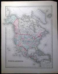
Map Cartography 19th Century OW. Gray North America O. W.
Map of North America
Philadelphia PA: O.W. Gray & Son 1882. One sheet printed with 1 map from the 1882 O.W. Gray National Atlas New York Edition: North America. Copyright noted at bottom edge Colton 1855. With hand-coloring in pastel tones; Approx. 14" x 17 1/4" overall size; a little even toning to the paper right margin with a few little edge-nicks; in very good condition. Map. Not Bound. Very Good. O.W. Gray & Son paperback books
Référence libraire : 25035
|
|
|
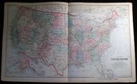
Map Cartography 19th Century OW. Gray United States O. W.
Gray's New Map of the United States By Frank A. Gray
Philadelphia PA: O.W. Gray & Son 1882. One sheet from the 1882 O.W. Gray National Atlas New York Edition: Double-page map of the United States with inset of the Territorial District of Alaska formerly Russian America and a smaller inset at top "Sketch Exhibiting the Westward Movement of the Centre of Population from 1790 to 1870."; text on back regarding U.S. population changes; at bottom margin of map copyright dated as 1879 O.W. Gray & Son. With hand-coloring in pastel tones; approx. 28 1/2" x 17 1/4" overall size; a little even toning to the paper with a few little edge-nicks; in very good condition. . Map. Not Bound. Very Good. O.W. Gray & Son paperback books
Référence libraire : 25037
|
|
|
MAP of SOUTH IRAN and IRAQ].
[OTTOMAN MAP of SOUTH IRAN and IRAQ] Simâlî Irak ve Iran haritasi.
Very Good Turkish, Ottoman (1500-1928) Original color map from an early 20th century Turkish atlas. Oblong folio. (25 x 35 cm). In Ottoman script. No scale. Shows South Iran with Lake Urmia at north and Iraq border at west. Toponyms are mostly in old Turkish. [OTTOMAN MAP of SOUTH IRAN and IRAQ] Simâlî Irak ve Iran haritasi.
|
|
|
MAP. CRUCHLEY (G. F.)
Cruchley's Improved Geographical Companion Throughout England & Wales Including Part of Scotland.
8vo, [2], 36pp., detailed general map divided into 36 sections corresponding with the index map at the beginning, neatly hand-coloured, cont. cloth, orig. printed label on upper cover. Includes a table of reference giving a list of cities with population figures for 1801, 1811 and 1821 with the distances from London, and index map. Inset of the Scilly Isles. "This New Map of England & Wales, as bound up in the form of a Book, possesses decided advantages over all other methods, by avoiding the unpleasant necessity of unfolding the whole at any one time".
|
|
|
MAP. WALKER (J. & C.)
A Geological Map of England, Wales, and Part of Scotland. Showing also the Inland Navigation, with the Railroads & Principle Roads.
Engraved map with contemporary hand-colouring, (1010 x 660 mm), divided into 25 sections and laid on linen, scale approximately 12 miles to the inch, occasional minor handling and age marks but overall in good condition, in restored orig. slip-case, orig. gold printed label on upper cover. A colour coded key provides information on 26 types of rock, with two horizontal sections beneath the map showing rocks and soils from Lands End to the German Ocean along an east-west line and a line north-south from St. Georges Channel to the English Channel.
|
|
|
MAPS.
The Art of the Map-Maker in Essex 1566-1860.
First Edition, 4to, coloured frontis., 30 plates, cloth.
|
|
|
MAPS. CELLARIUS.
Geographia Antiqua: being a Complete set of Maps of Antient Geography, Engraved from Cellarius. On Thirty-Three Copper Plates. Designed for the use of Schools, and of Gentlemen who make the Antient Writers their delight or study.
4to (270 x 200 mm), 2 double leaves of letterpress followed by 33 double-page engraved maps (as called for), library number to verso of title, bookplate, nineteenth-century diamond patterned brick red cloth.
|
|
|
MAPS; CARTOGRAPHY
The Monthly Newsmap. Volume I Number 1.
Chicago:: Newsmap Company 1938. First edition. single large sheet folded to form 28 pp. Light dust-soiling; otherwise fine. 8vo. Illustrated from maps in color. . This unusual periodical proposed to present "in a monthly series artistic and colorful maps and stories of description to supplement the voluminous current happenings each month." Newsmap Company, unknown
Référence libraire : 67918
|
|
|
MARTIN S. BRIGGS, F.R.I.B.A
A pictorial guide to cathédral architecture with a glossary of architectural terms.
Pitkin Pictorials LTD, joyaux de Grande Bretagne, 1963, bon état, brochure de 24 pages, in8.
Référence libraire : 5378
|
|
|
MARCEL DUBOIS CAMILLE GUY
Album géographique (tome 1 : Aspects généraux de la nature).
Armand Colin et Cie éditeurs, 1896, 247 pages, in 4 reliure demi chagrin, dos à 4 nerfs et mors en cuir noir, état général correct, quelques frottements et accocs, coins légèrement frottés et cornés, papier jauni, exemplaire bibliothèque.
Référence libraire : 7454
|
|
|
MARIEKE SPIES
BIJ NOORDEN OM: Olivier Bunel en de doorvaart naar Cina en Cathay in de zestiende eeuw
, Amsterdam University press, Amsterdam, 1994, originele omslag, 157pp, 17x24cm, talrijke ills. in z/w, als nieuw. ISBN 9789053560754.
Référence libraire : 3601
|
|
|
MARGUERITE D. PEACOCKE
Buckingham palace, the queen's London home.
Pitkin Pictorials LTD, joyaux de Grande Bretagne, environ années 1960, bon état, brochure de 24 pages, in8.
Référence libraire : 5381
|
|
|
MARC DELOUZE
C'est le monde qui parle.
2007 Verdier, 2007, 120 pages, in 8 broché, bon état.
Référence libraire : 14082
|
|
|
MARCEL DUBOIS
France et Colonies (cours supérieurs de géographie).
G.Masson éditeur, 1892, 640 pages, papier jauni, in 8 reliure éditeur cartonnée, quelques taches, usures et frottements, coins cornés, état d'usage.
Référence libraire : 7757
|
|
|
MARCEL GOSDIDIER DE MATONS
Géographie pour l'enseignement secondaire, géograhie générale Amerique Australasie.
Librairie A. Hatier, 1935, in8, reliure editeur cartonnée toilée, mauvais etat, coins corné et taches d'humidité sur les 2 plats, 240 pages.
Référence libraire : 5137
|
|
|
MARTHE EMMANUEL
JB.Charcot le " polar gentleman".
1945 Editions Alsatia, lettre et préface du Dr.Sottas, 1945, 192 pages + nombreuses photographies, in 8 broché, état d'usage, usures et frottements sur les bords des plats et le dos, coins cornés.
Référence libraire : 18618
|
|
|
MARCEL AUBERT
L'église de Conques.
Henri Laurens, collection Petites Monographies des Grands Edifices de la France, 1954, 68 pages, in 8 broché, état d'usage, quelques usures et frottements, coins cornés, papier jauni.
Référence libraire : 11625
|
|
|
MARCEL SCHNEIDER
La fin du carnaval.
Grasset, 1987, 242 pages, in 8 broché, avec jaquette illustrée, bon état.
Référence libraire : 10008
|
|
|
MARC LUC
La belle histoire de l'Union Française.
1954 IMA éditeur, 1954, 87 pages + illustrations, in 4 reliure éditeur cartonnée et toilée rose, titres or, état d'usage, couverture légèrement gondolée, usures et frottements sur dos et coiffes.
Référence libraire : 13581
|
|
|
MARC BOULET
La vie en jaune à l'usage de la Chine.
2008 Denoël, 2008, 364 pages, in 8 broché, bon état.
Référence libraire : 14077
|
|
|
MARGOT-DUCLOT Jean-Luc
LA FRANCE A L'ECHELLE histoire de la cartographie.
Solar, 1978, un volume in 8 broché, 203 pages, bon état.
Référence libraire : 6668
|
|
|
MARGOT-DUCLOT Jean Luc
La France à l'échelle : Histoire de la cartographie
Solar Solar 1978, In-8 broché, 199 pages. Bon état.
Référence libraire : 99915495

|
|
|
MARC GUITTENY
Le Comptat venaissin (ses itinéraires, son histoire, Orange, Vaison-la -Romaine, le mont Ventoux).
1984 Imprimerie Adia, mai 1984, 48 pages, brochure format in 8, bon état.
Référence libraire : 12602
|
|
|
MARCO POLO
Le livre des merveilles.
1982 Jean de Bonnot, 1982, 176 pages + 84 gravures hors texte, in 4 reliure éditeur cartonnée skaivertex, décors et titres or, bon état.
Référence libraire : 18607
|
|
|
 Recevoir par e-mail
 Télécharger en PDF
 Flux RSS


