|
|
|
Mifs (Miss) Marsh
Marsh: Unique Book of Hand-Drawn, -Coloured and -Lettered Maps
12 unnumbered leaves in what appears to be a contemporary off-the-shelf sketch book protected by a pale green protective outer layer/dust cover upon which is handwritten the name Marsh. Includes nine one-page tissue-protected hand-drawn, -coloured and -lettered maps of: Spain and Portugal; Hungary; Turkey in Asia; Persia; Egypt Arabia Nubia & Abyssinia; Holland; England & Wales; Austrian Empire; Settlement of Noah's Descendants Throughout the World; Palestine or the Holy Land, the last two maps appearing on the ninth leaf. Longitude and latitude indicated at periphery of each map. Many cities and water bodies indicated. Last three leaves blank. Provenance unknown. Handwritten name "Mifs" (Miss) "Marsh, Nov. 8th, 1838" upon verso of front cover. Oblong 29.5cm x 23.3cm. Light moisture marks throughout. Binding intact. We are left to speculate as to who Miss Marsh was and where she lived although, based on the writing, our guess would be that she was English. Given the relative thickness of the pages we believe it highly unlikely that these maps were traced. Rather, they appear to have been assiduously hand-drawn by Miss Marsh, presumably by referring to contemporary cartography. Miss Marsh would probably be amazed by the many border and name changes which have occured since 1838. Book

|
|
|
MIGUEL SALCEDO HIERRO
Cordoba y la mezquita (guide en espagnol).
Imprenta San-Pablo, Cordoba, 1965, bon état, in8, 118 pages.
Référence libraire : 5299
|
|
|
Migliorini,Elio.
L'Africa.
<br/> STATO: USATO, MOLTO BUONO.<br/> TITOLO: L'Africa. <br/> AUTORE: Migliorini,Elio.<br/> EDITORE: Unione Tipografica Ed. UTET<br/> DATA ED.: 1955,<br/>
|
|
|
Mikhailov,Nicolas.
Nouvelle Géographie de l'URSS.
<br/> STATO: USATO, MOLTO BUONO.<br/> TITOLO: Nouvelle Géographie de l'URSS. <br/> AUTORE: Mikhailov,Nicolas.<br/> CURATORE: Traduction de Charles Steber. Préface du Sir. Halford Mackinder.<br/> EDITORE: Payot<br/> DATA ED.: 1936,<br/> COLLANA: Bibliothéque Geographique.<br/>
|
|
|
Milano, Ernesto: Charta del Navicare. Carta del Cantino 1502.
(Faksimiledruck).
Modena, Biblioteca Estense, 1994. 103 x 220 cm. 2 Kommentarbändchen in Schuber.
Référence libraire : 1002CG

|
|
|
Millo, Antonio:
Der Weltatlas des Antonio Millo von 1586. – Portolan Atlas.
(Faksimileausgabe). Süssen, Deuschle, 1988. 1 Atlas (30 Bl.) mehrfarbige Karten Kommentarband (102 S.). Orig.-Leinenkassette und Leinenband.
Référence libraire : 6977CB
|
|
|
MILLION Claude
La topographie.
Couverture souple. Broché. 128 pages. Rousseurs.
Référence libraire : 127113

|
|
|
MILLE Jacques
La PROVENCE de CASSINI.
Jacques Mille Marseille 2024 In-8 oblong "à l'italienne" ( 215 X 305 mm ) de 128 pages, cartonnage illustré en couleurs de l'édition. Superbe et abondante iconographie en couleurs dans et hors-texte.Magnifique travail exhaustif et très richement documenté, ouvrage capital pour l'histoire de la cartographie en Provence au XVIIIe siècle. Ouvrage neuf.
Référence libraire : 824457

|
|
|
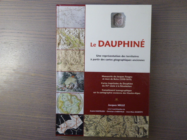
MILLE Jacques. CHATELON André. D'ABBOVILLE Gérard. BARFETY Jean Marc.
LE DAUPHINE, Une représentation des territoiresà partir des cartes géographiques anciennes. ( Manuscrits de Jacques Fougeu et Jean de Beins, cartes imprimées du Dauphiné du XVème siècle à la Révolution, Complément iconographiques sur a cartographie ancienne des Hautes Alpes).
1833 1833 1 volume in 8. 335 pages. très abondamment illustré. 2013. Etat neuf.
Référence libraire : 2487

|
|
|
MILLE Jacques - CHATELON André - D'ABOVILLE Christian - BARFETY
LE DAUPHINE. Une représentation des territoires à partir des cartes géographiques anciennes.
Naturalia Publications S.L. 2013 In-4 ( 305 X 215 mm ) de 334 pages, cartonnage à la bradel illustré en couleurs. Superbe et abondante iconographie en couleurs et en noir dans et hors-texte. Le "Maître-Livre" sur le sujet. Ouvrage neuf.Le premier volet concerne la cartographie manuscrite exhaustive du Dauphiné ( 1598-1619 ) par Jacques FOUGEU et Jean de BEINS, à partir d une trentaine de documents exceptionnels de la British Library, de la Bibliothèque nationale de France et de fonds privés. Le deuxième volet est constitué d un catalogue raisonné d une centaine de cartes imprimées du Dauphiné du XVe siècle à la Révolution. Le troisième, quant à lui, est consacré aux Hautes-Alpes pour compléter et prolonger jusqu au XXe siècle, avec près de cent vingt reproductions, la représentation cartographique du département déjà réalisée dans le premier ouvrage consacré à ce thème. Ce sont ainsi près de trois cents reproductions de cartes anciennes, manuscrites et imprimées, essentiellement en couleurs, issues de fonds privés et d institutions diverses, qui sont exposées dans cet ouvrage. Le livre se présente comme un triptyque prolongeant l ouvrage publié par l auteur en 2011 : Les Hautes-Alpes. Cartes géographiques anciennes ( XVe-mi XIXe siècle ).
Référence libraire : 893228
|
|
|
Milano, Ernesto: Charta del Navicare. Carta del Cantino 1502
(Faksimiledruck).
Modena, Biblioteca Estense, 1994. 103 x 220 cm. 2 Kommentarbändchen in Schuber. + Wichtig: Für unsere Kunden in der EU erfolgt der Versand alle 14 Tage verzollt ab Deutschland / Postbank-Konto in Deutschland vorhanden +, A
Référence libraire : 1002CG

|
|
|
Miller, Konrad
Itineraria Romana : Römische Reisewege an der Hand der Tabula Peutingeriana dargestellt.
Stuttgart, Strecker und Schröder, 1916. 4° (35x25), LXXV, 960 Sp, S. [961] - 992 (Register), mit 317 Kartenskizzen und Textbildern, OHln mit LnEcken, dreiseitiger Rotschnitt, [3 Warenabbildungen] (1. Aufl.) Einband mit marginalen Lagerspuren, sauber und gepflegt, nahezu ungelesen, schönes Exemplar,
Référence libraire : 52205AB

|
|
|
Miller, Konrad / Husslein, Gertrud (Hrsg/Einf)
Itineraria Romana : Römische Reisewege an der Hand der Tabula Peutingeriana dargestellt. Unveränderter Nachdruck der Ausgabe Stuttgart, Strcker & Schröder, 1916.
Bregenz, Eigenverlag Gertrud Husslein, 1988. 4° (35x25), LXXV, (1) S., 960 Sp, [961] - 992 S. (Register), mit 317 Kartenskizzen und Textbildern, grüner Oln mit goldPrägung, [2 Warenabbildungen] ungenutzt, schönes gepflegtes Exemplar, im Pappschuber,
Référence libraire : 52178AB

|
|
|
Millo, Antonio
Der Weltatlas des Antonio Millo von 1586. ? Portolan Atlas.
Süssen, Deuschle, 1988. 1 Atlas (30 Bl.) mehrfarbige Karten Kommentarband (102 S.). Orig.-Leinenkassette und Leinenband. + Wichtig: Für unsere Kunden in der EU erfolgt der Versand alle 14 Tage verzollt ab Deutschland / Postbank-Konto in Deutschland vorhanden +, A|B (Faksimileausgabe).
Référence libraire : 6977CB

|
|
|
MINISTERE DE L'INTERIEUR
100 kilomètres autour de Paris - Carte routière - I - Région ouest + 100 kilomètres autour de Paris - Carte routière - II - Région est.
Paris, Librairie Hachette, [s.d, 1910] 2 volumes 11 x 20,2cm Reliure éditeur demi percaline orangée; gardes orangées avec cartes et légendes. Dans chaque volume, 60 doubles pages dépliantes avec cartes couleurs au recto, vignettes en noir in texte au verso; soit 60 cartes couleurs dépliantes. Bon état.
Référence libraire : 19253
|
|
|
MINISTERE DES TRAVAUX PUBLICS.-
Carte Géologique de la France à l'échelle du millionième. Exécutée en utilisant les documents publiés par les Services de la carte géologique détaillée de la France par un Comité composé de 30 scientifiques.-
Paris. Charles Béranger. 1905. Très grande carte couleurs (115 x 110 cm) montée sur toile et composée de 24 pièces. Héliogravure d'Arents d'après la photographie de Huguenin. Ehrard Frères, imprimeurs à Paris. Les noms des 30 scientifiques sont tous cités. Tache brune intermittente en bordure de carte sinon bel exemplaire.
Référence libraire : ORD-17602

|
|
|
MINISCALCHI ERIZZO F.co
CARTA DELLE TERRE POLARI ARTICHE.
Tratta da quella dell'Ammiragliato inglese e corretta al 1853 dal conte Miniscalchi Erizzo. (1890 ca.). Carta geografica a colori raffigurante la regione artica, di mm. 610 x 620, telata, divisa in 9 riquadri. Con tracce d'uso, ma discreto esemplare.
Référence libraire : 63841
|
|
|
MINISCALCHI ERIZZO F.co
CARTA DELLE TERRE POLARI ARTICHE.
Dalla baia di Baffin all'isola di Baring. Corretta sopra documenti ufficiali al 1853 dal conte Miniscalchi Erizzo. 1853. Carta geografica a colori raffigurante la regione artica, di mm. 760 x 440, telata, divisa in 8 riquadri. Con tracce d'uso ma buon esemplare.
Référence libraire : 63843
|
|
|
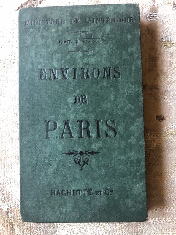
Ministère de l'Intérieur Service vicinal Mr Anthoine Ingénieur
ENVIRONS DE PARIS Carte à 1/100000ème
De format 560 X 650, entoilée, divisée en 18 parties permettant la pliure en accordéon, elle est protégée par 2 plaques cartonnées toilées (cf. photo). Publiée par Hachette et Cie, sans date, gravée par Ehrard, graveur-géographe (fin XIXème ). La carte est en bon état, des rousseurs côté toile et une petite corne à l'angle inférieur droit (sur 5mm environ).
Référence libraire : 2370
|
|
|
Ministère de la Défense Nationale
Instruction sur l'emploi du théodolite Jobin.
Bruxelles, Institut Cartographique Militaire, 1935. 14 x 22, 204-11 pages, 1 grande planche dépliante et volante, reliure d'édition pleine percaline brune, bon état (1 cachet d'ex-propriétaire).
Référence libraire : 90930
|
|
|
Ministère de la Défense nationale et de la guerre
Le service géographique de l'armée : son histoire, son organisation, ses travaux .
1938 Ministère de la Défense , Paris : Impr. du Service géographique de l'Armée, 1938,1 vol. broché,in folio,(191 p.-109 p. de pl.) ill.32 cm. Photos n/b à in et/ou hors-textes , cartes couleurs , plans ,L'historique du Service géographique de l'Armée pour les 50 premières années, de son institution ( 1887 ) à la date de ce beau livre 1938.Bon état.
Référence libraire : 24731

|
|
|
MINISTERE DES FORCES ARMEES
Manuel de topographie.
Charles Lavauzelle & Cie, 1948, 86 pages, in 8 reliure éditeur cartonnée, bon état.
Référence libraire : 10576
|
|
|
MINISCALCHI ERIZZO F.co
CARTA DELLE TERRE POLARI ARTICHE. Dalla baia di Baffin all’isola di Baring. Corretta sopra documenti ufficiali al 1853 dal conte Miniscalchi Erizzo.
Carta geografica a colori raffigurante la regione artica, di mm. 760 x 440, telata, divisa in 8 riquadri. Con tracce d’uso ma buon esemplare.

|
|
|
MINISCALCHI ERIZZO F.co
CARTA DELLE TERRE POLARI ARTICHE. Tratta da quella dell’Ammiragliato inglese e corretta al 1853 dal conte Miniscalchi Erizzo.
Carta geografica a colori raffigurante la regione artica, di mm. 610 x 620, telata, divisa in 9 riquadri. Con tracce d’uso, ma discreto esemplare.

|
|
|
MINISTERE DE L'INTERIEUR
100 kilomètres autour de Paris - Carte routière - I - Région ouest + 100 kilomètres autour de Paris - Carte routière - II - Région est.
60 cartes routières couleurs du service vicinal au 100.000e (28 + 28 + 4 sorties de Paris) et "principales curiosités" présentées en ordre alphabétique au verso des cartes, avec renvois aux cartes et petites photos. Complet en 2 volumes. Français
|
|
|
MINISTERE DES TRAVAUX PUBLICS ET DES TRANSPORTS INSTITUT GEOGRAPHIQUE NATIONAL.
[MAP OF INDO-CHINA] Indo-China. Carte generale de l'Indochine Française.
Very Good French A rare color lithograph map of French Indochina, showing international and provincial boundaries, transportation, and water features. Relief is shown by shading, spot heights, and bathymetric contours, as well as Cambodge, Thailande, Hai-Nan Island, Golfe du Tonkin, Mer de Chine, Yunnan Kouang-si, Kouang-Toung, Laos, Annam, Tonkin, Golfe du Siam, Bangkok, etc. Depths shown by contours. Prime meridians: Greenwich and Paris. "Compliled and drafted by l'Institut ge?ographique national, 1938. Revised by the Service ge?ographique de l'Indochine, 1948. Copied by AMS, 1951.". Original color map. Good. Folded. Double elephant folio. (93 x 66 cm). In French. 2 copies in OCLC (1948 Edition).; LCCN map59000405. Scale: 1/2000000. Restored on folded trace on right corner. A good copy.
|
|
|
MINISTERO DEGLI AFFARI ESTERI
RACCOLTA CARTOGRAFICA
IN 16°, pp.VIII + 372, RILEG.IN MEZZA TELA RECENTE, CON TASSELLO IN PELLE E TITOLO IN ORO. MANTENUTA LA COPERTINA ORIGINALE. OPERA INTERESSANTE DELLA DIREZIONE CENTRALE DEGLI AFFARI COLONIALI SULLA CARTOGRAFIA AFRICANA.<BR>OTTIMA CONSERVAZIONE.

|
|
|
MINISTERO DEL'AGRICOLTURA E DELLE FORESTE ..
Carta delle zone faunistiche della privincia di Cuneo. - 1° Compartimento Venatorio (Piemonte).
Carta del regno d'Italia, sul retro per cm. 70x77, l'Italia intera a colori, l'altro lato a foglio intero sempre a colori, la carta della zona di Cuneo. Carta ripiegata più volte.
|
|
|
Ministero della Guerra - Comando Corpo di Stato Maggiore.
NOZIONI DI TOPOGRAFIA PER LE SCUOLE ALLIEVI UFFICIALI DI COMPLEMENTO.
(Codice OS/0250) In 8° (23,5 cm) 136 pp. Con 67 figure. Antica firma d'appartenenza. Brossura originale, ottimo. ~~~ SPEDIZIONE IN ITALIA SEMPRE TRACCIATA

|
|
|
MINISTERO DELLA GUERRA.
Piano topografico di Roma.
Laboratorio foto - litografico del Ministero della Guerra, Roma, 1903. Carta in colore in scala di 1: 10.000, cm 75,5 x 98 circa. La carta si estende da Roccastrada e Grosseto a nord, a Gaeta, Isernia e il Volturno a sud. Usuali pieghe di chiusura, bross. in carta marrone con titolo e piccola illustrazione. Nome di coeva appartenenza e titolo elegantemente scritti su un riquadro esterno. Alcuni difetti della bross. e normali piccole aperture agli angoli di piega ma molto buono lo stato di conservazione della carta. .

|
|
|
Ministero della Marina Mercantile.
Codice internazionale dei Segnali. Manuale di ricerca e salvataggio per le navi mercantili ( Mersar ) . annuale di ricerca e salvatagg
<br/> STATO: USATO, MOLTO BUONO.<br/> TITOLO: Codice internazionale dei Segnali. Manuale di ricerca e salvataggio per le navi mercantili (Mersar). annuale di ricerca e salvataggio per le navi mercantili (MERSAR).<br/> AUTORE: Ministero della Marina Mercantile.<br/> EDITORE: Ist.Poligrafico e Zecca dello Stato-Archivi di Stato<br/> DATA ED.: 1983,<br/>
|
|
|
MINTO A. -
Per una carta archeologica sulle antiche coltivazioni minerarie del bacino mediterraneo.
Firenze, 1977, 8vo stralcio con copertina posticcia muta, pp. 303/312 (ristampa anastatica dell'edizione del 1948) . - !! ATTENZIONE !!: Con il termine estratto (o stralcio) intendiamo riferirci ad un fascicolo contenente un articolo, completo in se, sia che esso sia stato stampato a parte utilizzando la stessa composizione sia che provenga direttamente da una rivista. Le pagine sono indicate come "da/a", ad esempio: 229/231 significa che il testo è composto da tre pagine. Quando la rivista di provenienza non viene indicata é perché ci è sconosciuta. - !! ATTENTION !!: : NOT A BOOK : “extract” or “excerpt” means simply a few pages, original nonetheless, printed in a magazine. Pages are indicated as in "from” “to", for example: 229/231 means the text comprises three pages (229, 230 and 231). If the magazine that contained the pages is not mentioned, it is because it is unknown to us.

|
|
|
Minzoni,Alfonso.
Del moto dei pianeti. Natura elettromagnetica dei terremoti.
<br/> TITOLO: Del moto dei pianeti. Natura elettromagnetica dei terremoti. <br/> AUTORE: Minzoni,Alfonso.<br/> CURATORE: Con disegni originali dell'Autore.<br/> EDITORE: ditore Costantino Galleri<br/> DATA ED.: 1930,<br/> COLLANA: indirizzata a padre Guido Alfani, direttore dell'Osservatorio Ximeniano di Firenze.<br/>
|
|
|
MIOLA Alfonso
Contributi di studii e ricerche intorno ai Cimelii cartografici conservati in Napoli. Relazione
In 8 (cm 18 x 26,5), pp. 11 + (1b). Brossura editoriale. Estratto editoriale dagli Atti del V Congresso Geografico Italiano.
|
|
|
Miola Alfonso.
Contributo Di Studii E Ricerche Intorno Ai Cimeli Cartografici Conservati In Napoli.(Estratto).
Napoli,Tocco,1905. In 8°gr.pp.11n. Copertina anteriore editoriale conservata in bross.rifatta, mancante la posteriore.
|
|
|
MIOTTE Pietro (Attivo a Napoli nel XVII sec.)
Orbetello Assediato
Rarissima tavola iincisa da Pietro Miotte e stampata a Roma da Giovanni Giacomo De Rossi.Priva di data, l'opera viene realizzata in occasione del celebre assedio alla città del 1646.La città, parte dello Stato dei Presidi, era sotto la dominazione Spagnola. Tra il 9 maggio ed il 20 luglio 1646 Orbetello subì un assedio da parte dell'esercito francese, che venne respinto.Si tratta dunque di una delle cosiddette "stampe d'occasione" ovvero opera che nascevano per documentare un avvenimento, in genere bellico, e che gli editori si affrettavano a stampare per soddisfare la curiosità popolare. La tavola è di estrema rarità. La troviamo inserita nel'Indice delle Stampe De' Rossi, il catalogo delle opere della tipografia, pubblicato da Lorenzo Filippo de Rossi nel 1735. La stampa è descritta sotto "Città diverse" come "Assedio di Orbetello in foglio reale" e veniva venduta al prezzo di 5 baiocchi.Non abbiamo trovato traccia dell'opera in altre bibliografie o cataloghi di vendita di librerie antiquarie. Acquaforte, piccoli restauri perfettamente eseguiti alla piega centrale, per il resto in ottimo stato di conservazionei. Opera di grandissima rarità. Rarissima tavola iincisa da Pietro Miotte e stampata a Roma da Giovanni Giacomo De Rossi.Priva di data, l'opera viene realizzata in occasione del celebre assedio alla città del 1646.La città, parte dello Stato dei Presidi, era sotto la dominazione Spagnola. Tra il 9 maggio ed il 20 luglio 1646 Orbetello subì un assedio da parte dell'esercito francese, che venne respinto.Si tratta dunque di una delle cosiddette "stampe d'occasione" ovvero opera che nascevano per documentare un avvenimento, in genere bellico, e che gli editori si affrettavano a stampare per soddisfare la curiosità popolare. La tavola è di estrema rarità. La troviamo inserita nel'Indice delle Stampe De' Rossi, il catalogo delle opere della tipografia, pubblicato da Lorenzo Filippo de Rossi nel 1735. La stampa è descritta sotto "Città diverse" come "Assedio di Orbetello in foglio reale" e veniva venduta al prezzo di 5 baiocchi.Non abbiamo trovato traccia dell'opera in altre bibliografie o cataloghi di vendita di librerie antiquarie. Acquaforte, piccoli restauri perfettamente eseguiti alla piega centrale, per il resto in ottimo stato di conservazionei. Opera di grandissima rarità. Grelle Iusco, Indice delle Stampe de' Rossi, Contributo alla storia di una Stamperia romana, pp. 164, n. 10

|
|
|
MIR YAKOUB MAHDIYAV, (Azerbaijani politician, diplomat, intellectual and writer), (1891-1952).
[FIRST WORK ON BAKU AND AZERBAIJANI OIL] Beynelmilel siyasette petrol. [i.e. Oil in international politics]. Introduction by Mehmed Emin Resûlzâde.
Very Good Turkish, Ottoman (1500-1928) Original wrappers. Demy 8vo. (21 x 14 cm). In Ottoman script (Old Turkish with Arabic letters). 83 p. Chipped on extremities of pages and cover, minor stains on edges. Otherwise a good copy. First and only edition of this first work in book form on Baku and Azerbaijani oil. After the occupation of the Republic of Azerbaijan by the Red Army, many Azerbaijani intellectuals such as Mehmed Emin Resûlzâde (1884-1955) sought refuge in Turkey, established a publishing house called "Milli Azerbaycan Nesriyâti" [i.e. National Azerbaijan Publication] in 1928, Istanbul, and to make the voice of Azerbaijanis heard in exile to influence world public opinion. This book was published as the 9th publication of this publishing house. It was printed in Orhaniye Printing house in 1928 and was actually composed of the articles written by the author in the "Azeri-Turk" magazine. The first article appeared in the issue dated 15 August 1928, with other articles following it. The book, in which Mehmed Emin Rasülzade also penned a presentation, consists of the chapters: The Role of Oil in the World War, Azerbaijan at the Genoa Conference, Azerbaijan at the Hague Conference, the American Rivalry in Britain, A Common Front against the Bolsheviks, the Pursuits of the Oil Competition. Compiled from Mehdiyev's articles, is not only a propaganda work against the Russian occupation but also the first in-depth work written on Baku and Azerbaijan oil. Many sources in the text are referenced in footnotes. Mehdiyev says that world politics is shaped by the economy and oil is the most important factor in this context. In addition to expressing how important it is for the First World War, he also makes predictions about how oil will shape world politics in the future. According to Mehdiyev, whoever dominates the world's oil reserves will be the strongest state in the world. Based on M. Fanning, Mehdiyev states that Azerbaijani and Baku oil has an estimated 8 million barrels of resource rather than Mexican, American, Turkish, and Iranian oil. Only one paper copy in Bogaziçi University's Library in Turkey according to the OCLC: 82001141.; Özege 1960.
|
|
|
MIRLIVA ALI SEREF PASHA, (Author and mapmaker of 'Umûmî Cografya Atlasi' published in 1894 - Active between 1885-1905).
[ONE OF THE EARLIEST "USA" APPEARANCE IN AN OTTOMAN MAP] Cemâhîr-i Müttefikâ-i Amerika. Sâye-i Türkiye cenâb-i cihâniyâni [.] saltanât-i Osmânî veliünniamet-i alemiyân el-gazi Abdülhamid Hân-i Sâni'de meshur Haset sarfindan bittertîb Fransiz Encümen-i Cografya azalarindan mütesekkil komisyona mahsus tanzîm ettirilmis oldugu son def'a atlasi Maarif Umûmiye Nezâret-i Celîlesi ruhsatiyle Erkân-i Umûmiyye Dairesi Besinci Fen Subesi'ne me'mûr piyade mirlivâlarindan saâdetlü Ali Seref Pasa maarifetleriyle tersîm ve tercüme edilib tab' olunmusdur.
Very Good Turkish, Ottoman (1500-1928) Original color map. Folded. Oblong folio. (35 x 52 cm). In Ottoman script. Color lithograph. A very detailed and attractive Ottoman map of America. Scale: 1:12.000.000. Otherwise a very good copy. Slightly chipped extremities. Dated Hegira: 1311 = [Gregorian 1895]. Ali Seref Pasa or Hafiz Ali Esref. He was a soldier, who was schooled in Paris as a cartographer around 1862. Already in Paris he published his first atlas with 22 maps, called 'Yeni atlas'. Upon his return to Istanbul he became a chief cartographer at the Maatbaa-i amire Printing Press in Beyazit, which was the successor of the Muteferrika press from 1727. Among others he translated the large Kiepert map of Anatolia to Ottoman. He died in 1907, leaving his large project of a gigantic map of Anatolia in 100 sheets unfinished. Ali's name is often misunderstood or even listed as two different people: Ali Seref Pasa and Hafiz Ali Esref. Until the surname law adopted on June 21, 1934, Turks did not have surnames. They were born with one first name and were until the adulthood described only as sons or daughters of their parent's names. Later they were given titles such as Effendi (Sir), Bey (Chief) or Hanim (Madam) for higher classes, or they were given names according to their work or class. The names were not inherited by children until 1934, when the surname law was enforced. The map maker Ali received names Seref, the honourable, and Pasa, the dignitary. He was also known as Hafiz, the memorizer of Qur'an and Esref, Proud. So Ali Seref Pasa would have a meaning 'Honourable Dignitary Ali, and Hafiz Ali Esref, Memorizer of Qur'an, Proud Ali. Daruttibaa - Matbaa-I Amire Printing Press: The first press in the Muslim world, called Daruttibaa, was founded in Istanbul by Ibrahim Muteferrika in 1727, with a permission of Sultan Ahmeet III. It was located in Muteferrika's house. The first book was published in 1729 and until 1742 sixteen other works followed. After Muteferrika's death, the press was supressed for printing, as printed books were considered dangerous. In 1796 the press was purchased by the government and moved to Uskudar in Istanbul, and in 1831 finally to Beyazit, where it was renamed to Matbaa-i Amire in 1866. The press was closed in 1901 and was reopened in 1908 under the name 'Âmire' In 1927 the name changed to State Printing House. The press still exists and is known for publishing school and educational books. Extremely rare. Not in OCLC.; Not in TBMM Map Collection.
|
|
|
MIRLIVA ALI SEREF PASHA, (Author and mapmaker of 'Umûmî Cografya Atlasi' published in 1894 - Active between 1885-1905).
[OTTOMAN MAP of AUSTRIA-HUNGARY] Avusturya-Macaristan: Sâye-i Türkiye Hazret Gazi Sultan Abdülhamid Hân-i Sâni'de Maarif Umûmiye Nezâret-i Celîlesi ruhsatiyle Haset tarafindan Fransa Cemiyet-i Cografya âzâlarindan mütesekkil komisyona mahsûs tanzîm edilmis oldugu son atlasinin tercümesi olarak bu def'a Erkân-i Umûmiyye Dairesi Besinci Fen Subesi'ne me'mûr piyade mirlivâlarindan saâdetlü Ali Seref Pasa maarifetleriyle tersîm ettirilmistir.
Very Good Turkish, Ottoman (1500-1928) Original color chromo-lithograph map. Folded. Oblong folio. (40 x 50 cm). In Ottoman script. Color lithograph. An attractive map which shows Austria-Hungary land with Venice Bay and North Italy. Scale: 1:3.500.000. Dated Hegira: 1310 = [Gregorian 1894]. This uncommon map of Austria-Hungary in Ottoman script was published in an atlas, 'Yeni cografya atlasi', which was issued in Istanbul in the late 19th century. Ali Seref Pasa or Hafiz Ali Esref. He was a soldier, who was schooled in Paris as a cartographer around 1862. Already in Paris, he published his first atlas with 22 maps, called 'Yeni atlas'. Upon his return to Istanbul, he became a chief cartographer at the Matbaa-i Amire Printing Press in Beyazit, which was the successor of the Muteferrika press from 1727. Among others, he translated the large Kiepert map of Anatolia to Ottoman. He died in 1907, leaving his large project of a gigantic map of Anatolia in 100 sheets unfinished. Ali's name is often misunderstood or even listed as two different people: Ali Seref Pasa and Hafiz Ali Esref. Until the surname law adopted on June 21, 1934, Turks did not have surnames. They were born with one first name and were until adulthood described only as sons or daughters of their parent's names. Later they were given titles such as Effendi (Sir), Bey (Chief), or Hanim (Madam) for higher classes, or they were given names according to their work or class. The names were not inherited by children until 1934 when the surname law was enforced. The mapmaker Ali received names Seref, the honorable, and Pasa, the dignitary. He was also known as Hafiz, the memorizer of the Qur'an and Esref, Proud. So Ali Seref Pasa would have a meaning 'Honourable Dignitary Ali, and Hafiz Ali Esref, Memorizer of Qur'an, Proud Ali. Daruttibaa - Matbaa-I Amire Printing Press: The first press in the Muslim world, called Daruttibaa, was founded in Istanbul by Ibrahim Muteferrika in 1727, with permission of Sultan Ahmet III. It was located in Muteferrika's house. The first book was published in 1729 and until 1742 sixteen other works followed. After Muteferrika's death, the press was suppressed for printing, as printed books were considered dangerous. In 1796 the press was purchased by the government and moved to Uskudar in Istanbul, and in 1831 finally to Beyazit, where it was renamed to Matbaa-i Amire in 1866. The press was closed in 1901 and was reopened in 1908 under the name 'Âmire' In 1927 the name changed to State Printing House. The press still exists and is known for publishing school and educational books. Extremely rare. Not in OCLC.; Not in TBMM Map Collection.
|
|
|
MIRLIVA ALI SEREF PASHA, (Author and mapmaker of 'Umûmî Cografya Atlasi' published in 1894 - Active between 1885-1905).
[OTTOMAN MAP of SPAIN & PORTUGAL] Ispanya & Portekiz: Sâye-i Türkiye Hazret Gazi Sultan Abdülhamid Hân-i Sâni'de Maarif Umûmiye Nezâret-i Celîlesi ruhsatiyle Haset tarafindan Fransa Cemiyet-i Cografya âzâlarindan mütesekkil komisyona mahsûs tanzîm edilmis oldugu son atlasinin tercümesi olarak bu def'a Erkân-i Umûmiyye Dairesi Besinci Fen Subesi'ne me'mûr piyade mirlivâlarindan saâdetlü Ali Seref Pasa maarifetleriyle tersîm ettirilmistir.
Very Good Turkish, Ottoman (1500-1928) Original color chromo-lithograph map. Folded. Oblong folio. (40 x 50 cm). In Ottoman script. Color lithograph. It Portugal and Spain with Gibraltar and North African shores. Scale: 1:3.500.000. Dated Hegira: 1310 = [Gregorian 1894]. OTTOMAN MAP of SPAIN & PORTUGAL] Ispanya & Portekiz: Sâye-i Türkiye Hazret Gazi Sultan Abdülhamid Hân-i Sâni'de Maarif Umûmiye Nezâret-i Celîlesi ruhsatiyle Haset tarafindan Fransa Cemiyet-i Cografya âzâlarindan mütesekkil komisyona mahsûs tanzîm edilmis oldugu son atlasinin tercümesi olarak bu def'a Erkân-i Umûmiyye Dairesi Besinci Fen Subesi'ne me'mûr piyade mirlivâlarindan saâdetlü Ali Seref Pasa maarifetleriyle tersîm ettirilmistir. This uncommon map of Spain and Portugal in Ottoman script was published in an atlas, 'Yeni cografya atlasi', which was issued in Istanbul in the late 19th century. Ali Seref Pasa or Hafix Ali Esref. He was a soldier, who was schooled in Paris as a cartographer around 1862. Already in Paris he published his first atlas with 22 maps, called 'Yeni atlas'. Upon his return to Istanbul he became a chief cartographer at the Maatbaa-i amire Printing Press in Beyazit, which was the successor of the Muteferrika press from 1727. Among others he translated the large Kiepert map of Anatolia to Ottoman. He died in 1907, leaving his large project of a gigantic map of Anatolia in 100 sheets unfinished. Ali's name is often misunderstood or even listed as two different people: Ali Seref Pasa and Hafiz Ali Esref. Until the surname law adopted on June 21, 1934, Turks did not have surnames. They were born with one first name and were until the adulthood described only as sons or daughters of their parent's names. Later they were given titles such as Effendi (Sir), Bey (Chief) or Hanim (Madam) for higher classes, or they were given names according to their work or class. The names were not inherited by children until 1934, when the surname law was enforced. The map maker Ali received names Seref, the honourable, and Pasa, the dignitary. He was also known as Hafiz, the memorizer of Qur'an and Esref, Proud. So Ali Seref Pasa would have a meaning 'Honourable Dignitary Ali, and Hafiz Ali Esref, Memorizer of Qur'an, Proud Ali. Daruttibaa - Matbaa-I Amire Printing Press: The first press in the Muslim world, called Daruttibaa, was founded in Istanbul by Ibrahim Muteferrika in 1727, with a permission of Sultan Ahmeet III. It was located in Muteferrika's house. The first book was published in 1729 and until 1742 sixteen other works followed. After Muteferrika's death, the press was supressed for printing, as printed books were considered dangerous. In 1796 the press was purchased by the government and moved to Uskudar in Istanbul, and in 1831 finally to Beyazit, where it was renamed to Matbaa-i Amire in 1866. The press was closed in 1901 and was reopened in 1908 under the name 'Âmire' In 1927 the name changed to State Printing House. The press still exists and is known for publishing school and educational books. Extremely rare. Not in OCLC.; Not in TBMM Map Collection.
|
|
|
Misa Mazza, a cura di
Libro de li Prati del Monasterio di Chiaravalle. Cartografia
Misa Mazza, a cura di Libro de li Prati del Monasterio di Chiaravalle. Cartografia. Milano, Provincia di Milano 2001 italian, 12 CLL02Brossura editoriale,Cartelletta contenente 12 carte geografiche, volume in ottime condizioni, copertina in condizioni eccellenti, interno come nuovo, legatura salda,12 pagine circaCopertina come da foto

|
|
|
MITZI BALES A.WINANDY L.DERGENT M.DESCY B.LAHURE
Sur le chemin de l'aventure: Les explorateurs célèbres.
1983 Editions Christophe Colomb, Connaissance et Vie (Connaissances de l'Homme Moderne), 1983, 336 pages, in 4 reliure éditeur cartonnée skaivertex marron, titres or, avec jaquette illustrée, bon état.
Référence libraire : 13584
|
|
|
Mogg ES. E. S.
MODERN LONDON AND ITS ENVIRONS FOR 1849
London: E.S. Mogg 14 Great Russell Treet Covent Garden 1849. Exhibiting a Circle of Three Miles from the General Post Office to Which is Added A COPIOUS INDEX Containing Upwards of 1500 Places with Reference to Their Several Situations.Large folding un-dissected oblong map laid on linen 54x70cms Original hand-colour to the circle parks and main routes. A very nice dark impression generally dusty but a rare map. Fine engraved map title to the upper right-hand corner. Upper lateral fold triflle cracked but sound with no loss. Index in attached case 30pp with upwards of 2000 places. v adspp. PLEASE EMAIL FOR PHOTOS. 1st edition. Folding Map. V.g. E.S. Mogg, 14 Great Russell Treet, Covent Garden unknown
Référence libraire : GT072
|
|
|
MOHAMMAD FAKHR AL-DIN, (Arabian cartographer).
[MAP OF ARABIAN PENINSULA] Jazirat al-Arab.
Very Good Arabic Original printed b/w map. Folded. 21,5 x 34,5 cm. In Arabic. Chipped on extremities. A good print. No scale. Shows Arabian Peninsula and Mecca, Bilad al-Sam.
|
|
|
MOHAMMAD HAMDAN, AL-HASSAL LABIB, (Mapmakers and prepared by).
Plates 28 & 29: [Arabic map of population of Europe [with] Spain and Portugal] Tawzi' al-sukkan fî Uwrubba [with] Espania wa Bortugal.
Very Good Arabic Original b/w map. Some stains on extremities. Some hand-colouring on borders of Spain & Portugal map. Oblong 4to. (20x27 cm); Maps' sizes: 15x21 cm apprx. In Arabic. Two maps with front and its verso. Plate numbers 28 & 29. From one of late editions of 'Al-atlas al-hadithat fî takhtit aqalim al'arz siyasiyya wa iqtisadiyya hesab minhaj wa zarat'al-meraz fî al-umumiyya'. Mohammad Hamdan and Hassal Labib were two geography teachers (muderris) and cartographers in 'Amiri' School according to the info of 'Atlas'.
|
|
|
MOHAMMAD HAMDAN, AL-HASSAL LABIB, (Mapmakers and prepared by).
Plates 30 & 31: [Arabic map of Spain and Portugal [with] France] Hasilat-i Esbania wa Bortugal [with] Fransa.
Very Good Arabic Original b/w map. Some stains on extremities. Oblong 4to. (20x27 cm); Maps' sizes: 15x21 cm apprx. In Arabic. Two maps with front and its verso. Plate numbers 30 & 31. From one of late editions of 'Al-atlas al-hadithat fî takhtit aqalim al'arz siyasiyya wa iqtisadiyya hesab minhaj wa zarat'al-meraz fî al-umumiyya'. Mohammad Hamdan and Hassal Labib were two geography teachers (muderris) and cartographers in 'Amiri' School according to the info of 'Atlas'.
|
|
|
MOHAMMAD HAMDAN, AL-HASSAL LABIB, (Mapmakers and prepared by).
Plates 32 & 33: [Arabic map of France [with] Italy] Hasilat-i Fransa [with] Italia.
Very Good Arabic Original b/w map. Some stains on extremities. Oblong 4to. (20x27 cm); Maps' sizes: 15x21 cm apprx. In Arabic. Two maps with front and its verso. Plate numbers 32 & 33. From one of late editions of 'Al-atlas al-hadithat fî takhtit aqalim al'arz siyasiyya wa iqtisadiyya hesab minhaj wa zarat'al-meraz fî al-umumiyya'. Mohammad Hamdan and Hassal Labib were two geography teachers (muderris) and cartographers in 'Amiri' School according to the info of 'Atlas'.
|
|
|
MOHAMMAD HAMDAN, AL-HASSAL LABIB, (Mapmakers and prepared by).
Plates 34 & 35: [Arabic map of Italy [with] Balkan Peninsula] Hâsilât-i Italia [with] Al-Balkan.
Very Good Arabic Original b/w map. Some stains on extremities. Oblong 4to. (20x27 cm); Maps' sizes: 15x21 cm apprx. In Arabic. Two maps with front and its verso. Plate numbers 34 & 35. From one of late editions of 'Al-atlas al-hadithat fî takhtit aqalim al'arz siyasiyya wa iqtisadiyya hesab minhaj wa zarat'al-meraz fî al-umumiyya'. Mohammad Hamdan and Hassal Labib were two geography teachers (muderris) and cartographers in 'Amiri' School according to the info of 'Atlas'.
|
|
|
MOHAMMAD HAMDAN, AL-HASSAL LABIB, (Mapmakers and prepared by).
Plates 36 & 37: [Arabic map of Balkan Peninsula and Greece [with] Austria, Hungary and Slovakia] Hâsilât-i memâlik al-Balkan [with] Al-Namsa wa al-Majar wa tashqu Sluwakia.
Very Good Arabic Original b/w map. Some stains on extremities. Oblong 4to. (20x27 cm); Maps' sizes: 15x21 cm apprx. In Arabic. Two maps with front and its verso. Plate numbers 36 & 37. From one of late editions of 'Al-atlas al-hadithat fî takhtit aqalim al'arz siyasiyya wa iqtisadiyya hesab minhaj wa zarat'al-meraz fî al-umumiyya'. Mohammad Hamdan and Hassal Labib were two geography teachers (muderris) and cartographers in 'Amiri' School according to the info of 'Atlas'.
|
|
|
MOHAMMAD HAMDAN, AL-HASSAL LABIB, (Mapmakers and prepared by).
Plates 38 & 39: [Arabic map of Austria, Hungary and Slovakia [with] Germany] Hâsilât al-numsa wa al-Majar wa tashqu Sluwakia [with] Almania.
Very Good Arabic Original b/w map. Some stains on extremities. Oblong 4to. (20x27 cm); Maps' sizes: 15x21 cm apprx. In Arabic. Two maps with front and its verso. Plate numbers 38 & 39. From one of late editions of 'Al-atlas al-hadithat fî takhtit aqalim al'arz siyasiyya wa iqtisadiyya hesab minhaj wa zarat'al-meraz fî al-umumiyya'. Mohammad Hamdan and Hassal Labib were two geography teachers (muderris) and cartographers in 'Amiri' School according to the info of 'Atlas'.
|
|
|
 Recevoir par e-mail
 Télécharger en PDF
 Flux RSS


