|
Schuler,C.J.
Cartografare il mondo.
Cartografare il mondo è una storia della cartografia mondiale per immagini. Nel corso dei secoli la nostra conoscenza del pianeta si è sempre più approfondita grazie a viaggi ed esplorazioni e i cartografi hanno disegnato mappe sempre più accurate e precise anche delle aree più “misteriose”. Oggi grazie anche ai siti web siamo in gradi di avere una visuale “in diretta” anche dei posti più lontani <br/> STATO: NUOVO.<br/> TITOLO: Cartografare il mondo. <br/> AUTORE: Schuler,C.J.<br/> CURATORE: Traduzione di Cillero e De Motta.<br/> EDITORE: Logos<br/> DATA ED.: 2010,<br/> EAN: 9788857600093

|
|
|
Schulten, Adolf
Die Mosaikkarte von Madaba [Madeba] und ihr Verhältnis zu den ältesten Karten und Beschreibungen des Heiligen Landes. Mit 3 Kartenbildern und einer Figurentafel.
RARE comprehensive monograph on the Madaba Map (also known as the Madaba Mosaic Map) which is part of a floor mosaic in the early Byzantine church of Saint George at Madaba, Jordan. The Madaba Map dates to the 6th century AD and contains the oldest surviving original cartographic depiction of the Holy Land and especially Jerusalem. The author - Adolf Schulten (1870-1960) was an eminent German historian and archaeologist. Contains a reproduction of the Madaba map on two pages and full-page plate with 6 b&w figures. 270x210mm. 121 pages. Hardcover with cloth spine. Cover yellowing, stained/age-stained, somewhat curved and wrinkled. Wormholes on cover and spine. Cover edges and corners bumped and worn. Spine worn. Spine edges peeling. Spine hinges partly cracked and tattered. Sticker residues on spine bottom part. Ink writing on front inner cover, whitepage and title page. Ex-library copy with stamp on front and rear whitepages, and contents page. Wormholes on inner cover, whitepages and edges of all pages - NO damage to text. Wormholes on Madaba map with slight damage to middle part and hinge. Pages yellowing. [SUMMARY]: This extremely rare book on the oldest map of the Holy Land and Jerusalem has sustained some damage, but is still in good reading condition.
|
|
|
Schumann,Walter.
Der neue BLV Steine - und Mineralienführer.
<br/> STATO: USATO, MOLTO BUONO.<br/> NOTE: Mende alla sopracoperta.<br/> TITOLO: Der neue BLV Steine- und Mineralienführer. <br/> AUTORE: Schumann,Walter.<br/> CURATORE: Über 600 Einzelstücke in Farbe.<br/> EDITORE: BLV<br/> DATA ED.: 1991,<br/> EAN: 9783405131227
|
|
|
Schumann,Walter.
Guide des pierres et minéraux. Roches, gemmes et météorites.
<br/> STATO: USATO, MOLTO BUONO.<br/> TITOLO: Guide des pierres et minéraux. Roches, gemmes et météorites. <br/> AUTORE: Schumann,Walter.<br/> EDITORE: Delachaux et Niestlé<br/> DATA ED.: 1994,<br/> COLLANA: Coll.Les Guides du Naturaliste.<br/> EAN: 9782603006801
|
|
|
Schwartz Seymour I.; & Ralph E. Ehrenberg
The Mapping of America
New York: Harry N. Abrams Inc 1980. Near Fine condition in a Near Fine dust jacket. The jacket is protected by a removable Brodart clear-plastic sleeve. NOT a library discard. NO underlining. NO highlighting. NO margin notes. Sharp corners. Previous owner's bookplate. Small remainder mark on bottom edge. 1980. This is the Harry N. Abrams First Edition NOT the commom Wellfleet reprint. Among 354 illustrations are 223 maps 84 in full color. A classic work. Bound in the original white cloth stamped in bright gold on the spine. Complete with dust jacket. Oversize Hardcover. Oblong. 11.75" wide by 11" tall by 1.75" thick. This large heavy book will require extra postage for Priority and International shipments but only the standard charge for media mail. First Edition. Oversize Hardcover. Near Fine condition/Near Fine dust jacket. 363pp. Great Packaging Fast Shipping. Harry N. Abrams, Inc Hardcover
Référence libraire : 021804 ISBN : 0810913070 9780810913073
|
|
|
Schwartz Seymour I.; & Ralph E. Ehrenberg
The Mapping of America
New York: Harry N. Abrams Inc 1980. Fine condition in a Near Fine dust jacket. The jacket is protected by a removable Brodart clear-plastic sleeve. NOT a library discard. Pages are fresh crisp clean and unmarked. Sharp corners. NO owner's name or bookplate. NOT a remainder. 1980. This is the Harry N. Abrams First Edition NOT the commom Wellfleet reprint. Among 354 illustrations are 223 maps 84 in full color. A classic work. Bound in the original white cloth stamped in bright gold on the spine. Complete with dust jacket. Oversize Hardcover. Oblong. 11.75" wide by 11" tall by 1.75" thick. This large heavy book will require extra postage for Priority and International shipments but only the standard charge for media mail. First Edition. Oversize Hardcover. Fine condition/Near Fine dust jacket. 363pp. Great Packaging Fast Shipping. Harry N. Abrams, Inc Hardcover
Référence libraire : 021803 ISBN : 0810913070 9780810913073
|
|
|
Schwartz Seymour I.
The mismapping of America.
pp. 233, cm 23x15, paperback edition.
|
|
|
Schweydar, W
Harmonische Analyse d. Lotstörungen durch Sonne u. Mond.
Potsdam, 1914. 4°. 72 S. OBr. Umschl. leicht angeschmutzt. (Veröffentl. d. Königl. Preusz. Geodät. Inst. N.F. 59)
Référence libraire : 159738
|
|
|
Schweydar, W
Theorie d. Deformation d. Erde durch Flutkräfte.
Potsdam, 1916. 4°. 51 S. OBr. Umschl. angeschmutzt u. leicht eingerissen. (Veröffentl. d. Königl. Preusz. Geodät. Inst. N.F. 66)
Référence libraire : 159741
|
|
|
Schwind, F. (Hrsg.)
Geschichtlicher Atlas von Hessen. Text- u. Erläuterungsband.
Marburg, 1984. 4°. M. 3 beilieg. Faltktn. XIV, 338 S. OLwd. Rücken m. kl. Fleck.
Référence libraire : 621087
|
|
|
Schworella, Rudolf (Hrsg.)
Kurzer Leitfaden zur Orientirung im Gebiete der neueren Kartographie u. Geographie hrsg. v. d. Buchhandlung Schworella u. Heick, Wien.
Wien, Schworella & Heick 1881. Korrekturexemplar. 106 S., 31 S., mit Blankoblättern, 1 Karte, OHLn., berieb., geschossen, angestaubt, Ecken etw. bestoß., vord. flieg Vorsatz fehlt, zahlr. Anmerkungen von alter Hand.
Référence libraire : KART0136
|
|
|
Schäfke, Werner und Bodsch, Ingrid (Hrsg.)
Der Lauf des Rheines. Der Mittelrhein in illustrierten Reisebeschreibungen, Alben, Panoramen und Karten des 17. bis 19. Jahrhunderts aus den Beständen der Bibliothek und der Graphischen Sammlung des Kölnischen Stadtmuseums, der Stadthistorischen Bibliothek Bonn und des Stadtmuseums Bonn herausgegeben von Werner Schäfke und Ingrid Bodsch.
Köln, Bonn, Kölnisches Stadtmuseum, 1993. Folio. 41 x 31 cm. 127 Seiten. Original-Leinenband.
Référence libraire : 45225AB

|
|
|
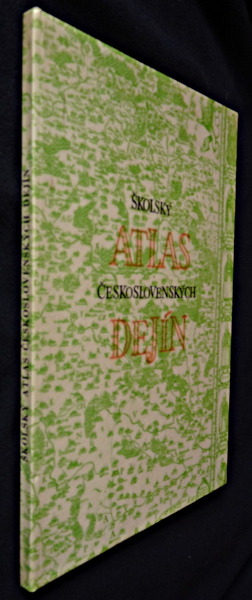
Scipak Jozef,Ulrich Stefan
Skolsky atlas ceskoslovenskych Dejin
Slovenska kartografia Album cartonné 1970 In-4 ( 21,5 x 30 cm.), album cartonné, couverture illustrée, 44 planches couleurs et 31 pages de commentaire, texte en slovaque ;plats à peine défraîchis, intérieur frais, très bon état. Livraison a domicile (La Poste) ou en Mondial Relay sur simple demande.
Référence libraire : qi1395
|
|
|
Scillacio,Nicola.
Delle isole del Mare Meridiano e Indiano recentemente scoperte.
<br/> STATO: USATO, MOLTO BUONO.<br/> TITOLO: Delle isole del Mare Meridiano e Indiano recentemente scoperte. <br/> AUTORE: Scillacio,Nicola.<br/> CURATORE: A cura di Osvaldo Baldacci.<br/> EDITORE: Olschki Ed.<br/> DATA ED.: 1992,<br/> COLLANA: Coll.Colombiana.<br/> EAN: 9788822239761
|
|
|
Scobel, A. (Hrsg.)
Andrees allgemeiner Handatlas in 126 Haupt- und 139 Nebenkarten. 4. neubearb. und vermehrte Aufl.
Bielefeld u. Leripzig, Velhagen & Klasing 1899. Folio, 2 Bl. Titelei, 186 farb. Karten, 179 S.; OHLdr., stark berieb., bestoß., Rücken fehlt zur Hälfte, Leder beschabt, Schmuckvorsätze, Karten in gutem Zustand.
Référence libraire : REIS0251
|
|
|
SCOLA GAGLIARDI REMO
L'immagine della pianutra veronese dal Tregnon all'Adige attraverso la cartografia veneta (Secoli XVI - XIX)
Cm. 29x27,50; pp. (20), 373, (3). Tela editoriale, titoli in oro, sovracoperta illustrata colorata. Ricco apparato illustrativo con schede descrittive di tutte la mappe presentate. Ottimo esemplare, come muovo 80/32
|
|
|
Scolaris Marco (a cura)
Le pi? belle falesie VALLE D'AOSTA - VALLEE D'AOSTE Les plus belles falaises a cura dell'Unione Valdostana Guide Alta Montagna
Le Guide di ALP arrampicata - Progetto grafico e copertina, Eliana Barbera - Cartografia, Eros Dell'Ozio - In copertina 'Il pilastro Lomasti'- Ringraziamenti - Prefazione - Simbologia - Soccorso Alpino Valdostano - Bibliografia 1 20x12,5 cm., in brossura, risvolti, carta ll'interno, pp. 111 (1), illustrazioni, figure, schizzi, prima edizione, in italiano e francese, buone condizioni. Una guida precisa e dettagliata che non pu? mancare nella biblioteca dei climber...raccoglie le numerose falesie sparse in tutta la Valle, molte delle quali recenti o inedite.
|
|
|
Scortecci Giuseppe
Nel paese degli uomini indaco. Hadramaut (Yemen)
disegni dell'autore

|
|
|
SCOTO FRANCESCO
AGRI PATAVINI
SCOTO FRANCESCO AGRI PATAVINI. , 1670, editore:in padova per mattio cadorin Ottimo (Fine) ottime condiz.. incisione in rame <br> cm. 19,5 x 19,5 <br> <br> <br>

|
|
|
Scott James W./De Lorme Roland L./Brandt Ted R. cartography/Grant Patrick S. cartography
Historical Atlas of Washington
Norman: University of Oklahoma Press 1988. 1st printing. VG/VG dust jacket. xxix 77 maps 77 p. text maps biblio index 4to; University of Oklahoma Press hardcover
Référence libraire : 65442 ISBN : 0806121084 9780806121086

|
|
|
SCOTT Valerie G.
Sussex. County Maps and Histories Series. FINE COPY
Roy. 8vo., First Edition, with numerous coloured and monochrome photographs and illustrations throughout; pictorial boards, a fine copy.

|
|
|
Scuola militare
Modelli di disegno topografico (10 tavole)
In 8° grande, 9(di 10) tavole f.t con l'illustrazione di modelli di disegno topografico militare. Brossura originale.

|
|
|
Scuola militare
Segni convenzionali in 7 tavole
In 8° grande, pp. 7. Brossura originale.7 tavole f.t.

|
|
|
SCUOLA MILITARE
SEGNI CONVENZIONALI. 1) Segni convenzionali in 6 TAVOLE, 1. Corso. 2) Principali TIPI e SEGNI convenzionali delle varie CARTE TOPOGRAFICHE e COROGRAFICHE edite dall'Istituto Geografico Militare a varie scale].
1) Modena, 1918. Cm. 25,2x17,8), cartellina grigia editoriale contenente 6 TAVOLE sciolte in bianco e nero, 1918. In cop. firma d'appart. si Dilvio Ferraria, € 20. 2) Senza data. Cm. 23,7x17). Cartellina in cartoncino editoriale leggero contenente il quadro d'unione dell carta topografica del Regno d'Italia alla scala 1: 100.000 + 10 TAVOLE sciolte in cartoncino (di cui 6 a colori) - in scala da 1.100.000 fino a 1:800.000. € 36. Le due cartelline € 44.
|
|
|
Scuola Militare.
MODELLI DI DISEGNO TOPOGRAFICO. I Corso.
(Codice OS/0262) Serie di 6 tavole sciolte. Copertina in brossura, firma. Ottimo stato. ~~~ SPEDIZIONE IN ITALIA SEMPRE TRACCIATA

|
|
|
Scuola Militare.
MODELLI DI DISEGNO TOPOGRAFICO. II Corso (6 tavole).
(Codice OS/0263) Serie di 6 tavole sciolte. Copertina in brossura, firma. Ottimo stato. ~~~ SPEDIZIONE IN ITALIA SEMPRE TRACCIATA

|
|
|
Scuola Militare.
PRINCIPALI TIPI E SEGNI CONVENZIONALI DELLE VARIE CARTE TOPOGRAFICHE E COROGRAFICHE edite dall'Istituto Geografico Militare.
(Codice OS/0265) Serie di 14 tavole sciolte, alcune a colori, + tavola del quadro s'unione della grande carta topografica del regno d'Italia alla scala 1:100.000. Copertina in cartoncino, dorso internamente riparato. Lievi segni del tempo, ma buono stato. ~~~ SPEDIZIONE IN ITALIA SEMPRE TRACCIATA

|
|
|
Scuola Militare.
SINOSSI DI GEOGRAFIA. Allievi e Sottufficiali Allievi. Ad uso esclusivo della Scuola e Fuori Commercio.
(Codice MT/1989) In 4º (315x210 mm) 259 pp. Varie figure. Intercalati vari fogli di appunti manoscritti rilegati tra le pagine. Alcuni antichi restauri marginali. Ex libris. Buona rilegatura in similpelle blu, titolo al dorso. Non inclusi i 38 schizzi allegati a parte. ~~~ SPEDIZIONE IN ITALIA SEMPRE TRACCIATA

|
|
|
Scuola Militare.
SINOSSI DI TOPOGRAFIA. Secondo corso Allievi e Sottufficiali Allievi. Ad uso esclusivo della Scuola e Fuori Commercio.
(Codice OS/0256) In 4º (315x210 mm) 176 pp. Ex libris. In fine la tavola "Itinerario della strada Caserta P.te di Annibale". Buona rilegatura in similpelle blu, titolo al dorso. Buono stato. ~~~ SPEDIZIONE IN ITALIA SEMPRE TRACCIATA

|
|
|
SCUOLE di APPLICAZIONE d'ARMA
MOSTRA del LIBRO in occasione dell'Anno Internazionale del Libro promosso dall'UNESCO. 1972.
In-8° (cm. 21,3x15,1), pp. 94. Cartoncino editoriale con veduta antica del Palazzo dell'Arsenale di Torino. In esposizione: 1. Manoscritti e mappe del Colonnello della Repubblica Veneta Antonio PARAVIA. 2. Documenti geografici (carte '600, '700, del Delfinato, Sevennes, Helvetia, Stati Sardi. 3. Carte e fortificazioni: Guerra d. Alpi Marittime 1793-94. Città e Cittadella di Alessandria 1814. 4, Aresenali e Fabbriche Militari. Artiglieria. 5. LIBRI e VEDUTE 600,'700, '800. 6. Arte e Incisioni: di Bartolomeo PINELLI e di Carlo Alessandro VON HEIDELOFF. 7. Opere di varia cultura, storia, scienze, anche di recente introduzione.
|
|
|
Scuole di Applicazione d'Arma.
SINOSSI DI GEOGRAFIA MILITARE- Tavole allegate alla parte Seconda.
(Codice MT/1415) In 4º oblungo (28x28,5 cm). Atlante di 49 tavole, grandi e ripiegate. Srampa litografica. Brossura originale, minimi strappetti riparati al dorso. Ottimo stato. ~~~ SPEDIZIONE IN ITALIA SEMPRE TRACCIATA

|
|
|
Seale RW. R. W.
MAP OF GALLIA BELGICA
London: John And Paul Knapton 1742. Double page folding uncoloured plate from 'Geographia Antiqua' 26x41cms. Undated.PLEASE EMAIL FOR PHOTO. Engraved form Cellarius. Paper. Fine. 4to. Printed Map. John And Paul Knapton Paperback
Référence libraire : Map900
|
|
|
Seale RW. R. W.
MAP OF GALLIA Narbonensis LvgdvnensisEtaqvitania
London: John And Paul Knapton 1742. Double page folding uncoloured plate from 'Geographia Antiqua' 26x41cms. Undated.PLEASE EMAIL FOR PHOTO. Engraved form Cellarius. Paper. Fine. 4to. Printed Map. John And Paul Knapton Paperback
Référence libraire : Map898
|
|
|
Seale RW. R. W.
MAP OF GERMANIA ANTIQVA
London: John And Paul Knapton 1742. Double page folding uncoloured plate from 'Geographia Antiqua' 26x41cms. Undated.PLEASE EMAIL FOR PHOTO. Engraved form Cellarius. Paper. Fine. 4to. Printed Map. John And Paul Knapton Paperback
Référence libraire : Map899
|
|
|
Seale RW. R. W.
MAP OF HISPANIA ANTIQVA
London: John And Paul Knapton 1742. Double page folding uncoloured plate from 'Geographia Antiqua' 26x41cms. Undated.PLEASE EMAIL FOR PHOTO. Engraved form Cellarius. Paper. Fine. 4to. Printed Map. John And Paul Knapton Paperback
Référence libraire : Map895
|
|
|
Seale RW. R. W.
MAP OF PANNONIA MOESIA DACIA ILLYRICUM
London: John And Paul Knapton 1742. Double page folding uncoloured plate from 'Geographia Antiqua' 26x41cms. Undated.PLEASE EMAIL FOR PHOTOS. The Northern Adriatic including Macedonia. Engraved form Cellarius. Paper. Fine. 4to. Printed Map. John And Paul Knapton Paperback
Référence libraire : Map894
|
|
|
Seale RW. R. W.
MAP OF SARMATIA
London: John And Paul Knapton 1742. Double page folding uncoloured plate from 'Geographia Antiqua' 26x41cms. Undated.PLEASE EMAIL FOR PHOTO. Engraved form Cellarius. Paper. Fine. 4to. Printed Map. John And Paul Knapton Paperback
Référence libraire : Map896
|
|
|
Seale RW. R. W.
MAP OF VINDELICIA RHAETIA ET NORICVM
London: John And Paul Knapton 1742. Double page folding uncoloured plate from 'Geographia Antiqua' 26x41cms. Undated.PLEASE EMAIL FOR PHOTO. Engraved form Cellarius. Paper. Fine. 4to. Printed Map. John And Paul Knapton Paperback
Référence libraire : Map897
|
|
|
Seboek Lou
Atlases Published in the Netherlands in the Rare Atlas Collection / Atlas publi�s aux Pays-Bas se trouvant dans la collection d'atlas rares
Ottawa: National Map Collection Public Archives of Canada 1973. Very Good condition. Covers lightly rubbed. NOT a library discard. NO owner's name or bookplate. Pages are clean and unmarked. NO underlining. NO highlighting. NO margin notes. A descriptive carto-bibliography with full collations contents notes lists of maps map measurements etc. Foreword by Theodore E. Layng Keeper of Maps in French and English. Subtitle: "No. 1 in a provisional series describing the atlases in the National Map Collection by country of origin." Bound in the original dark pink wraps stamped in white. 8.5" wide by 11" tall. . First Edition. Softcover. Very Good condition. xvii 132pp. Great Packaging Fast Shipping. National Map Collection, Public Archives of Canada Paperback
Référence libraire : 018834
|
|
|
Segeth Uwe-Volker
Spielkarten. Vom Jugendstil zu Art Deco.
Wien:, Ed. Brandst tter,, 1994 Hardcover with dusjacket 159 pages, Illustrated. ISBN 9783854474470.
Référence libraire : 62426
|
|
|
SEGRE Aldo G. -
Considerazioni sulla rappresentazione della morfologia carsica nelle carte topografiche.
Firenze, IGM, 1948, 8vo stralcio con copertina posticcia muta, pp. 521/528 con 7 cartine. - !! ATTENZIONE !!: Con il termine estratto (o stralcio) intendiamo riferirci ad un fascicolo contenente un articolo, completo in se, sia che esso sia stato stampato a parte utilizzando la stessa composizione sia che provenga direttamente da una rivista. Le pagine sono indicate come "da/a", ad esempio: 229/231 significa che il testo è composto da tre pagine. Quando la rivista di provenienza non viene indicata é perché ci è sconosciuta. - !! ATTENTION !!: : NOT A BOOK : “extract” or “excerpt” means simply a few pages, original nonetheless, printed in a magazine. Pages are indicated as in "from” “to", for example: 229/231 means the text comprises three pages (229, 230 and 231). If the magazine that contained the pages is not mentioned, it is because it is unknown to us.

|
|
|
Seidel, F
Über d. Prüfung d. Genauigkeit d. aus Luftlichtbildern hergestellten topographischen Grundkate 1:5000 von Amrum u. ihre Wirtschaftlichkeit.
Berlin, 1928. M.beilieg. Kte. u. einigen Tab. 26 S. OBr. (Mitteil. d. Reichsamts für Landesaufnahme So.-H. 7 ).
Référence libraire : 187315
|
|
|
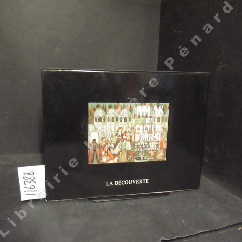
SELLIER, Jean - SELLIER, André - Cartographie Anne Le Fur
Atlas des peules d'Orient. Moyen-Orient, Caucase, Asie Centrale - Atlas des peuples d'Europe Centrale (2 volumes)
1995 Editions La Découverte - 1993 et 1995 - Nouvelle édition revue et mise à jour - 2 volumes in-8, brochés formats à l'italienne, couvertures illustrées, dans un coffret cartonné de l'éditeur - 200 + 200 pages - Nombreuses cartes en couleurs in texte
Référence libraire : 116388
|
|
|
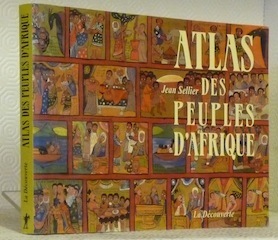
SELLIER, Jean.
Atlas des Peuples d’Afrique. Cartographie de Bertrand de Brun et Anne Le Fur.
Paris, La Découverte 2003, 180x240mm, 207pages, broché. Bel exemplaire.
Référence libraire : 63848
|
|
|
SELLER
Map of BEDFORDSHIRE
1787. HAND COLOURED F 6.25" X 5.5" . 1787. unknown
Référence libraire : Map030
|
|
|
SEMENZATO CAMILLO.
Padova illustrata. La città e il territorio in piante e vedute dal XVI al XX secolo.
in 4°, cart. edit. con sovracc. edit. ill. (piccolo strappo), pp. 208,(2), con ill. b.n. e seppia n.t., firma dell'A. al frontesp., edizione del 1989, ottimo es.
|
|
|
SEMENZATO CAMILLO.
Padua in Bildern. Stadt und Territorium nach Gravuren und Veduten vom 16. bis 20. Jahrhundert.
in 4°, t.t. edit. con sovracc. edit. ill. (tracce d'uso e riparazione interna con nastro adesivo), pp. 207,(1), prevalentemente ill., testo in lingua tedesca con didascalie in italiano, ottimo es. (m093)
|
|
|
Semjonow Juri
La conquista della Siberia. Epopea di un popolo e di un paese
21 tavole in nero fuori testo

|
|
|
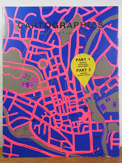
SendPoints Publishing Co. and Lin Gengli (Publisher)
Cartographics. Designing the modern Map
SendPoints Publishing Co., Hong Kong, 2016. 255 S. ; 30,5 x 23,5 cm ; Pp. ;
Référence libraire : 124480
|
|
|
SendPoints Publishing Co. and Lin Gengli (Publisher)
Cartographics. Designing the modern Map [English Edition]
SendPoints Publishing Co., Hong Kong, 2016. 30,5 cm ; Pp.
Référence libraire : 105344

|
|
 Recevoir par e-mail
 Télécharger en PDF
 Flux RSS


