|
Wiebeking Carl Friedrich von; Eckard, Johann Christian
Hydrographisch und militairische Karte von dem Nieder Rhein von Lintz bis unter Arnheim in X Blatt ; Sr: Hocfurstl :Durchlaucht dem Landgrafen von Hessen Darmstadt
Serie di 9 (su 10) incisioni all'acquaforte di mm 670 x 340 alla battuta su carta di gran corpo. Tutti i foglio a grandi margini in perfetto stato di conserazione. Carta in scala 1:30 000. Magnifica e molto rara opera cartografica sul Corso del Reno, purtroppo mancante dell'ottavo (8) foglio.
|
|
|
Wiggers, Hinke & Glerum, Huub
Speelkaarten Holland Casino
, Holland Casino, Ringband; COMPLEET; Inclusief kaartspel en losse bijlage met vertaling in Engels en Duits.
Référence libraire : 62446
|
|
|
Wigram The Rev. Joseph C.
THE GEOGRAPHY OF THE HOLY LAND;
London: Thomas Varty 1850. with an account of its ancient people and Kingdoms; their tribes; the journeyings of Our Lord; and the Modern Condition of Palestine.ND c1850 95pp 1 folding map outline hand-coloured 1 folding plan orig. blind stamped cloth gilt lettering front joint frayed and worn otherwise a nice copy. . 4th edition. hard back. V.g. 12mo. Thomas Varty hardcover
Référence libraire : C439
|
|
|
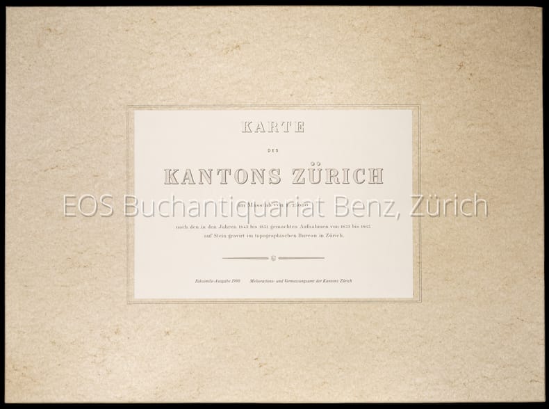
Wild, Johannes:
Karte des Kantons Zürich im Masstab von 1:25000 nach den in den Jahren 1843 bis 1851 gemachten Aufnahmen von 1825 bis 1865 auf Stein gravirt im topographischen Bureau in Zürich.
Zürich, Meliorations- und Vermessungsamt, 1990. 4°-quer. Titelblatt, Ueberischt und 30 faksimilierte, farbige Kartenblätter. 16 Seiten Dokumentation zur Faksimilierung. Orig. Pappschachtel mit Deckelschild.
Référence libraire : 1904CB
|
|
|
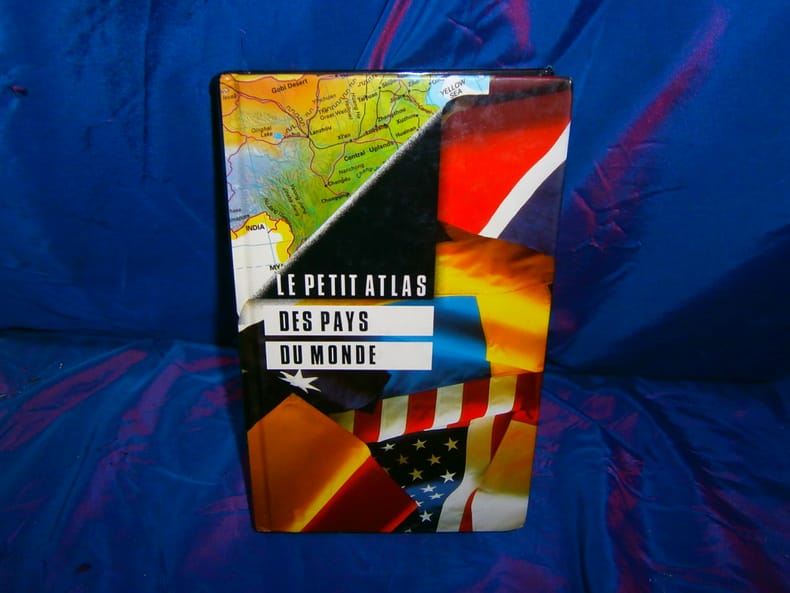
Williams Brian Lye Keith (cartographie)
Le petit Atlas des pays du monde
France Loisirs 1995 415 pages in8. 1995. cartonné. 415 pages.
Référence libraire : 87879
|
|
|
Williams Brian Lye Keith (cartographie)
Le petit Atlas des pays du monde
France Loisirs 1995 415 pages in8. 1995. cartonné. 415 pages.
Référence libraire : 75321

|
|
|
Williams Brian Lye Keith (cartographie)
Le petit Atlas des pays du monde
France Loisirs 1995 415 pages in8. 1995. cartonné. 415 pages.
Référence libraire : 98687

|
|
|
Wild, Johannes
Karte des Kantons Zürich im Masstab von 1:25000 nach den in den Jahren 1843 bis 1851 gemachten Aufnahmen von 1825 bis 1865 auf Stein gravirt im topographischen Bureau in Zürich.
Zürich, Meliorations- und Vermessungsamt, 1990. 4°-quer. Titelblatt, Ueberischt und 30 faksimilierte, farbige Kartenblätter. 16 Seiten Dokumentation zur Faksimilierung. Orig. Pappschachtel mit Deckelschild. + Wichtig: Für unsere Kunden in der EU erfolgt der Versand alle 14 Tage verzollt ab Deutschland / Postbank-Konto in Deutschland vorhanden +, A|B
Référence libraire : 1904CB

|
|
|
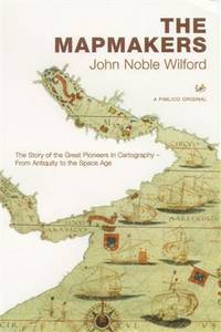
Wilford John Noble
The Mapmakers : The Story of the Great Pioneers in Cartography - From Antiquity to the Space Age
London: Plimlico 2002. 508pp. Unread copy. Pictorial card wrappers. Illustrated throughout. 1st Uk paperback. paperback. Mint. large 8vo. Plimlico Paperback
Référence libraire : S237 ISBN : 0712668128 9780712668125
|
|
|
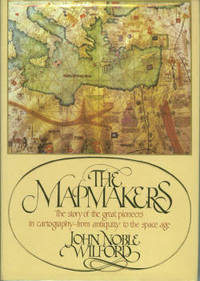
Wilford John Noble
The Mapmakers
New York: Alfred A. Knopf. Hardcover. 1981. 1st Edition. 8vo 414pp . Fine in Fine DJ. B&W Illustrations. The story of the great pioneers in cartography from antiquity to the space age . Alfred A. Knopf hardcover
Référence libraire : 002787 ISBN : 0394461940 9780394461946
|
|
|
Wilford, John Noble.
MAPMAKERS.
414p. Numerous illustrations. 8vo. Original printed wraps. **PRICE JUST REDUCED! REF4
|
|
|
WILHELM GREVE, (Map maker).; OSCAR FÜRSTENAU, (1826-1863), (Lithographer).
[LARGE COLLECTION OF MILITARY MAPS AND PLANS OF PRUSSIA] 53 Preussische Karten. [i.e. 53 Prussian maps].
Very Good German Original color lithograph maps in 7 special cloth cases. Cases large 8vo., only seventh one is smaller which is covered by European marbling. Bookseller and bibliothek stamps on some maps, plans and sketches; and cases interior. A fine map collection. Contents: V.1: Includes 1 map, 2 plans and 5 skecthes, 1 uebersichtskarte. Uebersichtskarte für die Geschichte des Iten und IIten schlesisschen Krieges von 1740-1745. Kriege Friedrichs des Grossen. 1/740000. 73x81 cm.; Plan zur Erstürmung von Glogam am 9 Marz 1741 (Entworfen nach alten Planen). 1/6250 / 1/100000. 48x52 cm; Plan der Schlach bei Mollwitz am 10 April 1741. 1/25000. 43x59 cm.; (Skizze) Stellung der preussischen und oesterreichischen Truppenam, 3 Januar 1741. 1/740000. 30x30 cm.; Skizze zum Scharmützel bei Ellguth und zum Gefecht bei Ottomachall am 9. Januar 1741. 1/67500. 34x26 cm.; Skizze zu den Winterquartieren des preussen mit Stellung der Truppen am 20 Februar 1741. 1/740000. 46x52 cm.; Skizze zum Ueberfall bei Baumgarten am 27 Feb. 1741. 1/50000. 29x34 cm.; Marsch der oesterreichischen Armee unter F. M. Neipperg und der preussischen Truppen unter dem Könige von der Schlacht bei Mollwitz. 1/1480000. 36x42 cm.; [.] Standorte des preussischen Heeres bei Ausbruch des Krieges 1740. 1/2400000. 34x55 cm.; V.2: 12 pieces: 3 uebersichtskarten, 2 planen, 7 skizzen. ... von Europa im Jahre 1756. 1/18000000. 33x46 cm.; ... des südöstlichen Kriegsschauplatzes. 1/740000. 65x95 cm.; Standorte des preussischen uns sachsischen Heeres und Stellung des oestreichischen Truppen in Böhmen, Mahren, oestrç Schlesen und Erzth. oesterreich var Beginn des siebenjahrigen Krieges. 1/2200000. 56x72 cm.; Plan der Schlacht bei Lobositz am 1. Oktober 1756. Verlauf des Schlact bis etwa 12 Uhr Mittags. 1/25000. 47x60cm (Also includes Plan der 2ten Attacke des preussischen Kavallerie and Skizze des beiderseitigen Vormarsches am 30ten September 1756).; ... Weiterer Verlaufdes Schlact bis etwa 3 Uhr Nachtmittags. 1/25000. 47x60 cm.; Skizzen: 1. Vormarssch 28. 8 bis 10.9.56. 2.-3. Pirna 1.10.56. 4. Bewegungen Schwerins 56. 5. Pirna 10.10.56. 6. Pirna 12.10.56. 7. Pirna 13.10.56. V.3: 5 skizzen (No: 8-12) und 3 plannen (No: 3, 4-A, 4-B). Plan 4-A-4-B: Prag, 6.5.1757.; Plan 3: Reichenberg, 21.4.57. Skizze 8: Postrungen und Winterquartiere Dezember 56 (Huge size).; Versammlung der Heere, Marz und April 57.; Einmarsch bis 30.4.57.; Stellungen am 1.5.57.; Stellungen am 5.5.57. V.4: Karten 1,2,3,5 (4 is missing); skies 31,32; uebersichtskarte 5; Plan 12-B. ... des nordöstlischen Kriegsschauplatzes (Huge size).; Skizze 31: Heeresbewegungen vom 11.11.57 bs zum Einrücken in die Winterquartiere, Winter 1757-58.; (World War 1): Karte 1: Belgien und nordost-frankreich. Ostpreussen, polen, kurland, Weissrussland.; Galizien und Wolkynien.; Kleinasien , Schweizes Meer, Kaukasien, Kurdistan, Armenien, Aserbeidschan, Arabier, Mittellandisches Meer: Vordasien map. V.5: Sizzen 20-24 - Planen 6-A, 6-B - 9. Planen: Gr. Jagersdorf, 30.8.57.; Jager b. Goerlitz, 31.8.-9.9.57. Moys, 7.9.57.; Breslau, 22.11.57.; Schweidnitz, 24.10-12.11.57.; Skizze 20: Feldzung in ostpreussen Vormarsch des russischen Heeres bis 6.7.57.; 21: Heeresbewegungen vom 6.7.57 bis zur Schlact bei Gr. Jagersdorf. 22: ... nach der Schlact bei Gr.-Jagersdorf bis zum Schluss.; 23: Bewegungen i. d. Lausitz u. i. Schleisen, 20.8.-30.11.57.; 24: Lager bei Liegnitz, 19.-27.9.57. V.6: Plan 5-A, 5-B - Skizzen no: 13-19. Plans: Kolin, 18.6.57.; Kolin, 18.6.57.; Skizzen 13: Beiderseitige Stellungen 8.5.57.; 14: Operationen Beverns u. d. Königs gegen Daun 10.5.-17.6.57.; Bewegungen vom 20.6.-1.7.57. Stellungen vom 1.7.57.; Rechten Elbufer in der ersten Halfte des Juli 1757.; ... vor Zittau, 12.-20.8.57. V.7: 4 plans in cloth covered with European marbling. These last 4 plans from "Suworow und Polens untergang. Nach archivalischen Quellen dargestellt" von Friedrich von Smitt, 1858 First Edition. Pl. 1: Der Schlact am Rymnik den 11/22 Septeember 1789. Pl. 2: ... der
|
|
|
WILKES (J.).
Cumberland.
London, 1802, mapa grabado en cobre, suavemente coloreado a mano, de 23'5 x 19 cm.
|
|
|
Wilkie, Richard W. ; Tager, Jack [Ed.]
Historical Atlas of Massachusetts
31.5x41 cm. 152 pages. Hardcover with dust jacket. Cover corners slightly rubbed. Else in good condition. PLEASE NOTE: This item is overweight. We may ask for extra shipping costs.
|
|
|
WILLIAM FRANKLIN [FRANCKLIN], (18th-19th century).
[RARE TROJAN MAP] Bemerkungen über die Ebene von Troja.; Uebersicht der neuesten geographischen Veranderungen in den Jahren 1799 und 1800 (Allgemeine Geographische Ephemeriden VII. Bds. erstes Stick. Januar 1801).
Very Good German Modern soft cover. Cr. 8vo. (20 x 12 cm). In German. 114 p., 1 folded map of Troia (Ebene von Troja) and one folded table (Statistische Tabelle auf das Jahr 1800). (Books is probably missing, because text is not completed on 114th page). Franklin's article pp. 25-64. Map of Troia (Charte von der Ebene von Troja) oblong 19x24 cm. Bemerkungen über die Ebene von Troja.; Uebersicht der neuesten geographischen Veranderungen in den Jahren 1799 und 1800 (Allgemeine Geographische Ephemeriden VII. Bds. erstes Stick. Januar 1801). It's just for sale for its map and Franklin's 'Troy'. Franklin was captain in the East India Company's service. His article of 'Bemerkungen über die Ebene von Troja" [Remarks and observations on the plain of Troy] reflects the romantic spirit of Europe in its period, especially on Hellenism. This volume (seventh) of the serie (Allgemeine Geographische Ephemeriden) is rare and map which it includes rare as well. Could not be found any copy of this volume in OCLC.
|
|
|
William Harbert on cartography and plate tectonics Ian McKay on map auctions Richard Pflederer on Fernao Vaz Dourado Jeffre
Mercator's World: The magazine of Maps Atlases Globes and Charts Volume 2 Number 4 July/August 1997
Aster Publishing. Used - Very Good. Very Good condition. Aster Publishing unknown
Référence libraire : P08C-00480
|
|
|
Williams Brian Lye Keith cartographie
Le petit Atlas des pays du monde
France Loisirs 1995. in8. cartonn�. 415 pages. France Loisirs unknown
Référence libraire : 98687

|
|
|
Williams Brian Lye Keith cartographie
Le petit Atlas des pays du monde
France Loisirs 1995. in8. cartonn�. 415 pages. France Loisirs unknown
Référence libraire : 87879

|
|
|
Williams Brian Lye Keith cartographie
Le petit Atlas des pays du monde
France Loisirs 1995. in8. cartonn�. 415 pages. France Loisirs unknown
Référence libraire : 75321

|
|
|
Wilmot Sydney editor; with J. K. Finch; Walter L. Huber; F. H. Peters; William L. Hartley; George R. Schneider; et al
Transactions of the American Society of Civil Engineers : Centennial Transactions Volume CT 1953
New York: American Society of Civil Engineers 1953. Fine condition. Bright clean square and tight. Sharp corners. Gilt on cover is still bright and shiny. No owner's name or bookplate. Pages are fresh and crisp. No underlining. No highlighting. No margin notes. Illustrations throughout. Author Index. Subject Index. Includes: A HUNDRED YEARS OF AMERICAN CIVIL ENGINEERING 1852-1952 by J. K. Finch pp. 28-96; AN ENGINEERING CENTURY IN CALIFORNIA by Walter L. Huber pp. 97-111; SURVEYING AND MAPPING IN CANADA 1852-1952 by F. H. Peters pp. 857- 871; WATERWAY GROWTH IN THE UNITED STATES by William L. Hartley pp. 976-1041; HISTORY AND FUTURE OF FLOOD CONTROL by George R. Schneider pp. 1042- 1099; etc. There are also papers on Civil Engineering - History and Practice; Engineering Education; City Planning; Construction; Irrigation; Power Sanitary Engineering; Soil Mechanics; Structural; Surveying; Transportation; Waterways; Allied Interests Metals in the Economy; Synergism between Engineering and Petroleum; Iron and Steel Production 1851-1951. Bound in the original black cloth. . First Edition. Hardcover. Fine condition/No dust jacket. 8vo. xii 1330pp. American Society of Civil Engineers Hardcover
Référence libraire : 003010
|
|
|
Winearls Joan ed
Editing early and historical atlases
North York ON Canada: University of Toronto Press 1995. xvii 199pp. Illustrated. 7 Papers Given at the Twenty-Ninth Annual Conference on Editorial Problems University of Toronto 5-6 November 1993. A sunned spine otherwise unread. 1st edition. hard back. Fine/V G sunned. 8vo. University of Toronto Press hardcover
Référence libraire : S238 ISBN : 080200623X 9780802006233
|
|
|
Winslow, A
The Mapping of Missouri.
St. Louis, 1892. M. 1 farb. Faltkte. u. zahlr. Ktn.-Skizzen. S. 57-99. OU. m. St. u. Sign. (Trans. of The Acad. of Science of St. Louis 6,3).
Référence libraire : 245892
|
|
|
Wirral Footpaths
FOOTPATHS OF WIRRAL Central
Liverpool: Wirral Footpaths & Open Spaces Preservation Society 1945. 3 inches to the mile. Folding map on linen with a card cover. A lovely copy in clean crisp almost new condition with outline paths printed in red and public open spaces in green. 31 x 27 inches. Printed by Brown & Bibby Ltd. Liverpool. Based on the ordnance survey map of the area. paper wrappers. Fine. Folding map. Wirral Footpaths & Open Spaces Preservation Society Hardcover
Référence libraire : V209
|
|
|
Wissen Media
AERIAL ATLAS OF THE WORLD
London: BCA 2006. 486pp. Atlas of the world with aerial photos of locations. As new. hardback. Fine/Fine. Folio. BCA Hardcover
Référence libraire : L1131
|
|
|
Wit, Frederik de
Carta Noua accurata del Paßagio et strada dalli Paesi Baßi per via de Allemgne per Italia et per via di Paesi suizeri a Geneua, Lione et Roma.[altkolorierter Kupferstich / handcolored copper engraving].
o.J.
Référence libraire : 46786BB

|
|
|
WITH COMPLIMENTS OF THE MINISTRY OF INFORMATION, KINGDOM OF SAUDI ARABIA.
Saudi Arabian map: The Kingdom of the Saudi Arabia.= Harita al-Mamlakat al-Arabiyya al-Saudiyya.
Very Good English Original folded color map. Oblong atlas folio. (60x91 cm). Bilingual in English and Arabic. Arabic map and texts with b/w photographs of some views from Saudi Arabia and English map and texts with b/w photos of Jeddah, Riyadh and Dhahran airports with legends and "distances in kilometers". It shows a very detailed landscape of entire Arabian Peninsula including Saudi Arabia, Aden, Oman, Muscat Qatar, Trucial Coast, Nafud, Dahna, Rub' Al-Khali, Najran, Asir, Yemen, Ramlat As Sab'atayn, Dhofar, Al Mahrah, Hadhramaut, Kuwait, Neutral Zone, and others.
|
|
|
WITT DE, (1630-1703).
Occidentalior Tractus Maris Mediterranei / Wester Gedeelte van de Middelandse Zee
Carta geografica incisa in rame (cm. 48,5x57,5 e margini) con bellissima colorazione coeva. Classica carta eseguita sul modello dei portalani. In De Wit si combinano magistralmente la precisione geografica e il dettaglio artistico. Gli Olandesi apprezzavano molto anche il fattore estetico e l'incantevole gusto decorativo di Wit fu un ulteriore elemento per il suo successo. Dopo la morte di De Wit e di suo figlio, le lastre vennero acquistate da Louis Renard, che le diede di nuovo alle stampe con un suo testo. Reiner e Josua Ottens ristamparono l'atlante di Renard nel 1739 con testo in francese e di nuovo nel 1745 con testo in olandese e i loro nomi incise sulle lastre per la prima volta.. .

|
|
|
WITT DE, Federico.
Novissima et accuratissima Septentrionalis ac Meridionalis Americae descriptio...
Carta geografica incisa in rame (cm. 48,6x57 e margini) con bellissima colorazione coeva. Bella carta geografica raffigurante l'America Settentrionale e quella Meridionale, interessante è l'introduzione di alcuni elementi quali: la California raffigurata come isola, i Grandi Laghi lo Stretto di Anian e nella parte meridionale i territori del Quiri Regio, le isole Salmon, la Nuova Guinea. In De Witt si combinano magistralmente la precisione geografica e il dettaglio artistico. Gli Olandesi apprezzavano molto anche il fattore estetico e l'incantevole gusto decorativo fu un ulteriore elemento di successo. Dopo la morte di De Wit e di suo figlio, le lastre vennero acquistate da Louis Renard, che le diede di nuovo alle stampe con un suo testo. Reiner e Josua Ottens ristamparono l'atlante di Renard nel 1739 con testo in francese e di nuovo nel 1745 con testo in olandese e i loro nomi incise sulle lastre per la prima volta. Bella e rara carta geografica, con mancanza in parte dell'America settentrionale (restaurata) e precisamente nella sezione pigmentata in verde, dove l'acidità del colore naturale ha creato dei sollevamenti e delle crepe.. .
|
|
|
WITT DE, Federico.
Poli Arctici et Circumiacentium Terrarum descriptio novissima Per Fredericum de Wit, Amstelodami.
Carta geografica incisa in rame (cm. 48,8x58 e margini) con bellissima colorazione coeva. Bella carta geografica raffigurante il Polo Nord, che inclde l'Europa Settentrionale, parte della Siberia, della Groenlandia e del Canada Orientale (Baie di Baffins, di Button e di Hudson). L'altra metà del circolo è denominata "Americae Septentrionalia incognita" e "Tartaria Maritima incognita". Gli angoli del quadrato entro cui è inscritto il cerchio sono decorati da scene con navi, cetacei ed animali artici. In De Wit si combinano magistralmente la precisione geografica e il dettaglio artistico. Dopo la morte di De Wit e di suo figlio, le lastre vennero acquistate da Louis Renard, che le diede di nuovo alle stampe con un suo testo. Carta molto inusuale e decorativa.. .
|
|
|
Wolff Christian.
ELEMENTA GEOGRAPHIAE ET HYDROGRAPHIAE.
(Codice OS/0268) Volume monografico completo, capitolo autonomo tratto dall'opera "ELEMENTA MATHESEOS UNIVERSAE, Tomus II". In 4° antico (223x175 mm) da p. 607 a p. 702 + 4 tavole ripiegate con numerose incisioni in rame. Senza frontespizio, ma con proprio titolo. Capolettera.Testo su 2 colonne, in latino. Carta normalmente ossidata, in buone condizioni. Legatura moderna tutta tela, titolo tipografico al dorso. Ottimo stato. ~~~ SPEDIZIONE IN ITALIA SEMPRE TRACCIATA

|
|
|
Wood H. J.
La scoperta del mondo
illustrazioni

|
|
|
Wood,H.J.
La scoperta del mondo.
<br/> TITOLO: La scoperta del mondo. <br/> AUTORE: Wood,H.J.<br/> CURATORE: Trad.dall'ingl.di R.degli Uberti.<br/> EDITORE: Sansoni<br/> DATA ED.: 1960,<br/> COLLANA: Coll.Le Piccole Storie Illustrate.<br/>
|
|
|
Woodward, David
Catalogue of Watermarks in Italian Printed Maps. (ca 1540-1600).
cm. 17,5 x 24,5, 206 pp. con 335 ill. n.t. e 335 grafici. Rilegato. Biblioteca di bibliografia italiana Questo catalogo rappresenta la prima raccolta importante di radiografie di filigrane, indispensabile per quelle istituzioni che posseggono collezioni di carte geografiche, stampe, disegni, musiche o manoscritti italiani del sedicesimo secolo. Sono fornite 335 riproduzioni di filigrane con la descrizione generale della filigrana, data, titolo, bibliografia, localit? Testo inglese. This catalogue represents the first important collection of watermarks indispensable for those institutions possessing sixteenth century Italian geographical maps, prints, drawings, music or manuscripts. 335 watermark reproductions are supplied with a general description of the actual mark, the date, its title, bibliography and location. Inglese 720 gr. 206 p.
|
|
|
Woodward, David;Hermon Dunlap Smith Center for the History of Cartography
Five Centuries of Map Printing
177 pages including bibliography and index. Black and white illustrations. "Histories of cartography have long suffered from a major deficiency: they ignore or slight the technical history of map making. (This book) brings together the basic knowledge of the historical techniques of map printing." - from inside jacket. Light wear. Usual library markings. A worthy working copy. Book

|
|
|
WORKMS (Laurence) & BAYNTON-WILLIAMS (Ashley)
British Map Engravers: A Dictionary of Engravers, Lithographers and their Principal Employers to 1850.
First edition, thick royal 8vo, xxxii, 744pp., 600 illustrations, orig. publishers blue cloth, d.w. An illustrated dictionary of well over 1,500 members of the map-trade in the British Isles from the beginnings until the mid nineteenth century, including all the known engravers and lithographers, all the known globemakers and retailers, the principal mapsellers and publishers, the key cartographers, the makers of map-based games and puzzles, and others. Each entry includes a list of published work, the known biographical facts (in most cases based on fresh and original research), addresses and dates, details of apprentices, etc. Twenty-five years in the making, the book contains previously unpublished material on almost every page.
|
|
|
Workshop on Automated Cartography and Epidemiology : Arlington Va.
Proceedings of the 1976 Workshop on Automated Cartography and Epidemiology : March 18-19 1976 Arlington Virginia 1979 Leather Bound
2020. Leather Bound. New. SPECIAL DISCOUNTED PRICE DURING COVID PANDEMIC. Leather Binding on Spine and Corners with Golden Leaf Printing on round Spine. Reprinted in 2020 with the help of original edition published long back 1979. This book is printed in black & white sewing binding for longer life Printed on high quality Paper re-sized as per Current standards professionally processed without changing its contents. As these are old books we processed each page manually and make them readable but in some cases some pages which are blur or missing or black spots. If it is multi volume set then it is only single volume if you wish to order a specific or all the volumes you may contact us. We expect that you will understand our compulsion in these books. We found this book important for the readers who want to know more about our old treasure so we brought it back to the shelves. Hope you will like it and give your comments and suggestions. Lang: - eng Pages 92. EXTRA 10 DAYS APART FROM THE NORMAL SHIPPING PERIOD WILL BE REQUIRED FOR LEATHER BOUND BOOKS. FOLIO EDITION IS ALSO AVAILABLE. hardcover
Référence libraire : LB1111016761251
|
|
|
Wos Jan Wladislaw
Itinerario in Polonia del 1596 di Giovanni Paolo Mucante cerimoniere pontificio. Parte prima. Cracovia
illustrazioni

|
|
|
Wouter Bracke
Grote Atlas van Ferraris / Le Grand Atlas de Ferraris. 1:20 000 - grande edition ! groot formaat !
Tielt, Racine-Lannoo, 2018 Bound / Gebonden, Formaat : 405 x 510cm. Aantal pagina's : 600 pagina's . large Edition ! ISBN 9789401442589.
Référence libraire : 21274
|
|
|
Wouter Bracke
Grote Atlas van Ferraris / Le Grand Atlas de Ferraris. 1:20 000 - grande edition ! groot formaat !
Bound / Gebonden, Formaat : 405 x 510 cm. Aantal pagina's : 600 pp. large edition ! ISBN 9789401442589. De eerste topografische atlas van Belgie in een nooit geziene uitgave - Eind 18de eeuw werd het grondgebied van het huidige Belgie voor het eerst volledig in kaart gebracht onder leiding van de Oostenrijkse graaf De Ferraris.- 275 met de hand getekende, topografische kaarten op een uiterst gedetailleerde schaal (1:11.520 verkleind naar 1:20 000)- Een uniek historisch document dat ons land toont voor de industriele revolutie, die het landschap grondig zou veranderen.- Een must voor landschapsdeskundigen, historici, geografen, heemkundigen en liefhebbers van geschiedenis- Tweetalige uitgave in samenwerking met de Koninklijke Bibliotheek van Belgie en het Nationaal Geografisch Instituut- Met een inleiding van Wouter Bracke, directeur Afdeling Kaarten en Plannen van de Koninklijke Bibliotheek.

|
|
|
Wright Edward
MAP OF THE WORLD A.D. 1600
London: Hakluyt Society 1880. A single sheet folding map based on the map in Richard Hakluyt's ' Principall Navigations Voyages and Discoveries of the English Nation' associated with Edward Wright map-maker. The Wright Molyneux map. Called by Shakespeare in Twelth Night ' the new map with augmentation of the Indies'. To illustrate the Voyages of John Davies'. Map only lacks the 16pp booklet. 29 x 21 inches. One small repair. A trifle foxed. PLEASE EMAIL FOR PHOTO. Produced by THE TYPOGRAPHICAL PRINTING COMPANY. 1st Edition. V.g. Folio. Hakluyt Society unknown
Référence libraire : S218
|
|
|
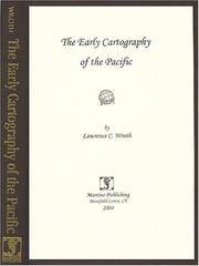
Wroth Lawrence C
The Early Cartography of the Pacific new in publisher's shrinkwrap
Mansfield Centre Connecticut: Martino Publishing 1999. Brand New HARDCOVER in perfect condition. STILL SEALED in the publisher's clear plastic SHRINKWRAP. NO rubbing. NO fading. Bright clean square and tight. Sharp corners. NO owner's name or bookplate. NO remainder mark. Fresh and crisp -- obviously never read. 1999 reprint of the 1944 original. A standard work. Illustrated with 22 FOLD-OUT maps. "An excellent study of those maps from Ptolemy to 1798 important in the development of the cartography of the Pacific area with facsimiles of 22 of the 104 maps described." -- Ristow 393 in GUIDE TO THE HISTORY OF CARTOGRAPHY. Hodgkiss/Tatham 137 in KEYGUIDE TO INFORMATION SOURCES IN CARTOGRAPHY. Bound in the original gilt-stamped brown cloth. Because this edition is bound in sturdy cloth it is much better suited to repeated use than the paper binding of the original edition. 1999 reprint of the 1944 original. Hardcover. New/in publisher's shrinkwrap. 8vo. vi pp. 87-268 22 folding plates. Great Packaging Fast Shipping. Martino Publishing Hardcover
Référence libraire : 017926 ISBN : 157898162X 9781578981625
|
|
|
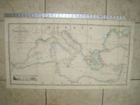
Wyld James 1812 1887
General Chart of the Mediterranean Sea Including the Gulf of Venice Archipelago and Part of the Black Sea with the Steam Packet Routes
London: James Wyld Geographer to Her Majesty Charing Cross East 1853. Very Good condition only a little light soil SEE PHOTOS. This huge detailed map of the Mediterranean measures 99.5cm by 54cm when unfolded. The image itself is 93.5cm by 47.5cm. There is a finely engraved view of the entrance of Gibraltar Bay in the lower left corner. The map is a linen-backed copper engraving with original hand coloring. The map has handsome marbled paper endsheets and when folded-up measures 18cm by 12.5cm. SEE PHOTOS. Published by James Wyld Geographer to Her Majesty Charing Cross East London. A New General Atlas of Modern Geography Consisting of a Complete Collection of Maps of the Four Quarters of the Globe; Delineating their Physical Features and Coloured to Show the Limits of Their Respective States 1853. First Edition. Linen-backed hand-colored map. Very Good condition. 99.5cm by 54cm when unfolded. Great Packaging Fast Shipping. James Wyld, Geographer to Her Majesty, Charing Cross East Paperback
Référence libraire : 020822
|
|
|
Wyld, James
Wyld?s new plan of London and its vicinity.
Wyld, London ca. 1875. Original hand-colour in block and outline, marking postal districts and railways in bold red. 21 segments, folded and linen-backed with marbled paper to folded end segments. Size 57x73, overall 59,5x77 cm. A bit tanned, verso a bit rubbed and stained.
Référence libraire : 12639

|
|
|
Wörmann, [Rudolf] W.A
Das practische Feldmessen und seine Anwendung in der Gärtnerei : Ein Handbuch für Gärtner, Gärtner-Gehülfen und Gärtner-Lehrlinge, Ingenieure, ARchitekten etc.
Berlin, Ernst Schotte & Co Verlagsbuchhandlung, [1864]. 8° (22x15), 112 S., mit 7 gefalteten lith (teils farblith) Tafeln [so komplett], marmor Hln d.Zt, angestaubt, Kanten bestossen, anfangs etwas fingerfleckig, die Tafeln angerändert und mit etwas Fehlfalzung, ordentliches festes Exemplar, [= Der Garten-Ingenieur; 4/2],
Référence libraire : 27105AB

|
|
|
XAVIER DE MAISTRE
Oeuvres choisies de Xavier de Maistre (Le lépreux de la cité d'Aoste, Les prisonniers du Caucase, La jeune sibérienne, Voyage autour de ma chambre, Le papillon).
Eugène Ardent & C.Thibaut, sans date, 192 pages, in 8 reliure percaline bleue, ouvrage orné du blason du collège de Soissons, bon état.
Référence libraire : 12278
|
|
|
Xiudong, Sun (Managing Editor) and Gu Lifen (Cartographic Examiner)
Atlas of the People's Republic of China
Foreign Languages Press, China Cartographic Publishing House, Beijing, 1989. 27 cm ; Pp.
Référence libraire : 103698

|
|
|
XIXe Corps d'Armée
Carte routière de la division de CONSTANTINE
Imprimerie du Service Géographique de l'Armée, 1938. In-8 broché allongé. Carte dépliante en couleurs. Très bon état.
Référence libraire : 16587
|
|
|
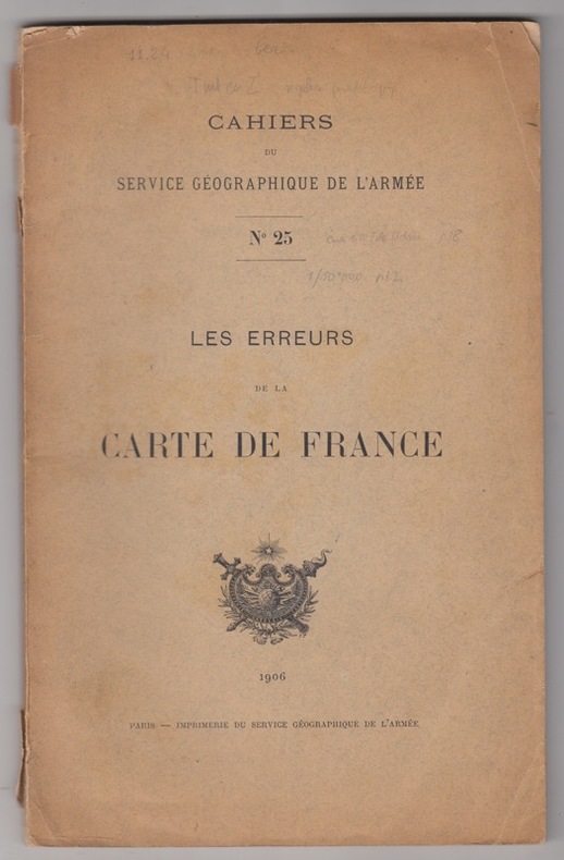
XXX - service géographique de l'armée
Les erreurs de la carte de France.
1906 Paris, Imprimerie du service géographique de l'armée, 1906. In-8, broché, couverture imprimée, 49 pp. 26 planches ht,Cartes et photographie.
Référence libraire : 18193
|
|
|
YASHA BERESINER
BRITISH COUNTY MAPS Reference and Price Guide
Vol. in -4 (22 x 28 cm.), legatura editoriale t.tela rossa, scritte in oro incise sul piatto e al dorso, pp. 295 con molte ill. a colori e b.n. nel testo e a p.pagina raffiguranti carte geografiche dell'inghilterra. Testo in inglese. In buone condizioni. Book in 4to, cloth red, gilt lettering, no dust-jacket, pp. 295 with ill. coloured and b/w. English text. Veri good condition.
|
|
 Recevoir par e-mail
 Télécharger en PDF
 Flux RSS


