|
Pohle, Richard und G. Brust (Bearbeitung)
Berliner Schulatlas. Auf Grund der 50. Auflage von Keil und Riecke: Deutscher Schulatlas. Faksimile der Berliner Originalausgabe von 1910 [mit entnehmbarer Faltkarte]
Köln: Komet Verlag, 2013. 30,5 cm ; Pp.
Referencia librero : 102118

|
|
|
Pohle, Richard und G. Brust (Bearbeitung)
Berliner Schulatlas. Auf Grund der 50. Auflage von Keil und Riecke: Deutscher Schulatlas. Faksimile der Berliner Originalausgabe von 1910
Augsburg: Weltbild Verlag, 2010. 31,5 x 24,5 cm ; Pp.
Referencia librero : 113122

|
|
|
Pohle, Richard und Gustav Brust
Berliner Schulatlas. Auf Grund der 50. Auflage von Keil und Riecke: Deutscher Schulatlas [Faksimile-Ausgabe]
Braunschweig: Archiv Verlag, 2002. 50 S. ; 30,5 x 25 cm ;
Referencia librero : 132069

|
|
|
POISSONS en SUISSE par J.-C. PEDROLI, B. ZAUGG. A. KIRCHHOFER.
Atlas de distribution des poissons et cyclostomes de Suisse. Richement documenté (planches en couleurs, cartes, tableaux). Texte bilingue français et allemand.
Neuchâtel, centre suisse de cartographie de la faune 1991. Bel exemplaire broché, couvertre ornée d'éd., gd in-8, 206 pages.
Referencia librero : AUB-3538
|
|
|
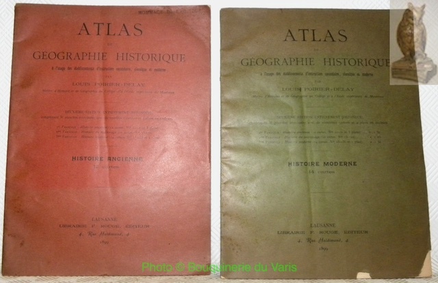
POIRIER-DELAY, Louis.
Atlas de géographie historique à l’usage des établissements d’instruction secondaire, classique et moderne. 2 fascicules. Histoire moderne 14 cartes. Histoire ancienne 12 cartes.
Lausanne, F. Rouge 1899, 285x210mm, broché. Bel exemplaire.
Referencia librero : 23997
|
|
|
POIRIER R.
Cartes des Richesses Economiques de la France
LES NOUVELLES DE L'ENSEIGNEMENT. Non daté. In-4. En feuillets. Bon état, Couv. légèrement passée, Dos satisfaisant, Intérieur frais. 24 planches de cartes en noir et blanc. Planches rangées dans une couverture au 2nd plat remplié.. . . . Classification Dewey : 912-Atlas, cartes et plans
Referencia librero : RO80073239
|
|
|
POIRIER R.
Petit Atlas de l'Economie Mondiale
LES NOUVELLES DE L'ENSEIGNEMENT. Non daté. In-4. En feuillets. Bon état, Couv. convenable, Dos satisfaisant, Intérieur frais. Pochette de 20 planches de cartes en noir et blanc + 1 calque illustré en noir et blanc.. . . . Classification Dewey : 912-Atlas, cartes et plans
Referencia librero : RO80129155
|
|
|
POIRIER-DELAY, Louis:
Petit atlas historique à l’usage des Collèges et des Ecoles industrielles. 2me & 3me partie (de 4): Histoire du moyen-âge & Histoire générale moderne.
Lausanne, F. Rouge & Cie En vente chez l’auteur / Autographie Ls. Magnemat et Fils / Impr. E. Graf, Rolle, 1916 / s.d. (ca. 189-), in-4to, oblong, 2 ff. titre & table + 10 cartes (N° 14-23) & Titre + 11 cartes en couleurs n° 17 à 27, sans couv. / brochure originale imprimée (manque sur la couverture). Fasc. usées.
Referencia librero : 134090aaf
|
|
|
Poirson
Petit Atlas de toutes les parties du monde
Paris, chez Henri Tardieu, Libraire 1811 "In-8 relié demi-basane, 22 x 15 cm., ""destiné aux jeunes gens des deux sexes; et autres personnes qui veulent étudier la géographie moderne, lire avec fruit l'histoire des derniers siècles et suivre la marche des armées. Il peut aussi servir à compléter tous les livres élémentaires de Géographie moderne qui ne renferment point de cartes géographiques "", complet des 21 cartes couleurs, ""cet atlas, gravé au burin par M. B. Tardieu, renferme les découvertes des Voyageurs modernes et les divisions politiques de l'Europe jusqu'au traité de Paix conclu entre la France et L'Autriche, le 14 octobre 1809 ; le dos est très abîmé, les cartes sont toutes en bon état sauf la carte dépliante qui présente des déchirures restaurées et de tout petits manques de papier, brunissures marginales, bon état. Livraison a domicile (La Poste) ou en Mondial Relay sur simple demande."
Referencia librero : lu2414
|
|
|
POLLACCHI P. (Commandant)
Atlas de la France et de ses colonies.
Couverture rigide. Cartonnage de l'éditeur. 21 cartes. Couverture légèrement défraîchie. 23 x 33, 5 cm.
Referencia librero : 84368
|
|
|
POLLACCHI, Paul
Atlas colonial français. Colonies, Protectorats et Pays sous mandat. Cartes et texte du commandant P. Pollacchi. 3e édition, revue et mise à jour
Paris, l'Illustration 1937 In-folio 41 x 31 cm. Reliure éditeur simili-cuir havane, report du titre doré sur le dos lisse muet et sur le premier plat de couverture orné d’un motif, 325 pp. dont 55 cartes, nombreuses gravures, index alphabétique, liste des cartes, table des matières. tête et pied de dos réparés sinon exemplaire en bon état.
Referencia librero : 129458
|
|
|
POLLET G., EGGERMONT P. & VAN DAMME G.
Corpus Topographicum Indiae Antiquae, II: Archaeological sites [in: Orientalia Lovaniensia Analecta, 37]
Leuven, Katholieke Universiteit Leuven. Departement Orientalistiek 1990 127pp. with 32 full-page maps, hardcover (publisher's green cloth with gilt lettering), 31cm., in the series "Orientalia Lovaniensia Analecta" volume 37, very good condition, ISBN 978-90-6831-259-1, X80291
Referencia librero : X80291
|
|
|
POLLET G., EGGERMONT P. & VAN DAMME G.
Corpus Topographicum Indiae Antiquae, II: Archaeological sites [in: Orientalia Lovaniensia Analecta, 37]
127pp. with 32 full-page maps, hardcover (publisher's green cloth with gilt lettering), 31cm., in the series "Orientalia Lovaniensia Analecta" volume 37, very good condition, ISBN 978-90-6831-259-1, X80291
|
|
|
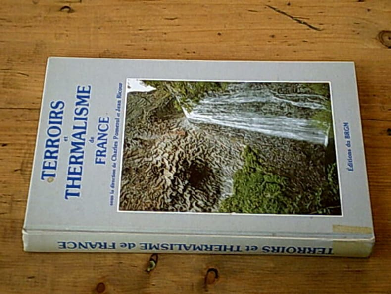
POMEROL Charles RICOUR Jean
Terroirs et thermalisme de france - Les eaux minérales françaises
Brgm 1992 288 pages in-8. 1992. cartonné. 288 pages. Nombreuses illustrations en noir et en couleurs
Referencia librero : 20045
|
|
|
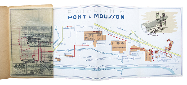
PONT-A-MOUSSON (PLAN DES USINES)
Sociétés des Fonderies de Pont à Mousson. Usine de Pont à Mousson.
Plan des unités de production de l'usine de Pont à Mousson dépliant (465 x 180 mm) en couleurs (échelle 1/5000e) sur l'ensemble du site, accompagné d'un calque d'architecte détaillant en transparence les machines, installations et équipements pour chaque bâtiment. Ensemble relié sous couverture illustrée. Pont à Mousson, sans date (vers 1930).
Referencia librero : 27063
|
|
|
PONT-A-MOUSSON (PLAN DES USINES)
Sociétés des Fonderies de Pont à Mousson. Usine de Pont à Mousson.
Plan des unités de production de l'usine de Pont à Mousson dépliant (465 x 180 mm) en couleurs (échelle 1/5000e) sur l'ensemble du site, accompagné d'un calque d'architecte détaillant en transparence les machines, installations et équipements pour chaque bâtiment. Ensemble relié sous couverture illustrée. Aucun exemplaire de ce document n'est répertorié. Il manque à la réunion des bibliothèques mondiales en ligne (WorldCat). Bon exemplaire.
|
|
|
Pontoppidan, Erich
Dänischer Atlas, oder Beschreibung des Königreichs Dännemark, nach seiner politischen und physikalischen Beschaffenheit. Mit Landkarten und andern Kupferstichen versehen. Aus dem Dänischen übersetzt, und mit einigen Anmerkungen begleitet von Johann Adolph Scheiben. Erster Band. Erster [und Zweyter] Theil [= alles Erschienene]. 2 Teile in einem Band.
Kopenhagen-Hamburg, Rothen Wittwe, Profft u. Michael Christian Bock, 1766-1767. Gr.-8°. Mit 4 gefalt. Kupferkarten, einem gefalt. Kupferplan und 21 (20 gefalt.) Kupfertafeln. XXXII, 464, XVIII, 276 S., Ppbd. d. Zt. m. reicher Rückenverg., goldgepr. Rückenschild u. dreiseitigem Rotschnitt.
Referencia librero : 58508

|
|
|
Pontoppidan, Erich / Johann Adolph Scheibe
Dänischer Atlas oder Beschreibung des Königreichs Dänemark nach seiner politischen und physikalischen Beschaffenheit. Mit Landkarten und anderen Kupferstichen versehen. [Übertragen und mit einigen Anmerkungen begleitet von Johann Adolph Scheiben]. Erster Band [von zwei].
Kopenhagen und Hamburg, Rothen Wittwe/ Profft/ Michael Christian Bock, 1765. Halbledereinband der Zeit, Rückenschildchen, 5 Bünde, gr-8°, 464 S., 1 mehrfach gefaltete Karte, 17 Tafeln mit zahlreichen Holzstichen, einige Vignetten im Text; -Kanten berieben, Rückengelenke angebrochen, gutes Exemplar.
Referencia librero : 17218

|
|
|
Poovendran, P.. (Editor)
The ttk Road Atlas of India.
Chromepet, Madras. (India)., T. T. Maps & Publications lt.., 1993. 20 Seiten Text (Einführung), 63 Seiten Karten und Entfernungstabellen. Zustand: Aus einer Insitutsbibliothek ausgeschieden, Vorsatz und Titelblatt mit Bibliotheksstempel und Inventarnummer. 8°. S OKunststoffeinband.
Referencia librero : 046449
|
|
|
POPE Margaret
SAHARA.
reliure éditeur - 17,5x27 - 192 pp - 1968 - éditions RENCONTRE, Lausanne.Collection " ATLAS DES VOYAGES, RENCONTRE" dirigée par Charles-Henri FAVROD.Nombreuses illustrations dans et hors texte.
Referencia librero : 4946
|
|
|
Poppendieck, Hans-Helmut (Hg.), Ingo Brandt (Hg.) und Jörg von Prondzinski (Hg.)
Die vom Aussterben bedrohten, stark gefährdeten und sehr seltenen Farn- und Blütenpflanzen von Hamburg. Arbeitsatlas - Stand November 2001. [Artenkataster und Artenhilfsprogramm Farn- und Blütenpflanzen in Hamburg Teil 1] Kartierungen von Horst Bertram, Dieter Wiedemann u.a. Mit Beiträgen von Meike Andersson, Holger Kurz, Veronika Schulte u.a. 1. Auflage
Hamburg; Ad-Fontes, Freie und Hansestadt Hamburg Umweltbehörde Naturschutzamt, Botanischer Verein Hamburg e. V., Regionalstelle für Pflanzenartenschutz, 2001. 186 S., Verbreitungskarten. Lex. 8° (=25-30cm), Broschiert
Referencia librero : 43511

|
|
|
PORCACCHI, Thomaso
L'Isole piu famose del Mondo. “L'Isole piu famose del Mondo“ de Porcacchi
La meilleure édition du Porcacchi sur l’Amérique, illustrée de 47 cartes par Girolamo Porro. L’un des plus grands exemplaires connus, conservé dans son pur vélin de l’époque. Venetia, Heredi di Simon Galignani, 1590.In-folio de (3) ff.bl., (12) ff., 201 pp., (1) p., (1) f.bl. Un frontispice gravé, 47 cartes sur cuivre et la marque de l’imprimeur à la fin. Qq. ff. piqués. Conservé dans son vélin souple de l’époque à petits rabats, dos lisse avec quelques manques, titre manuscrit sur la tranche inférieure. Reliure de l’époque.310 x 214 mm.
Referencia librero : LCS-6774

|
|
|
Poritsky, Ray / Barbara K. Freemann
Malatlas Neuroanatomie (Außentitel: Malbuch Neuroanatomie).
München : Elsevier / Urban & Fischer, 2005. VI, 314 S. (28 cm) Großformat, Broschierte Ausgabe
Referencia librero : 42031
|
|
|
POSTEL, Guillaume
De la République des Turcs : & là où l’occasion s’offrera, des meurs & loy de tous Muhamedistes. La société ottomane à la Renaissance par Guillaume Postel
L’édition originale de La République des Turcs de Guillaume Postel, « l’un des ouvrages les mieux documentés sur la société ottomane à la Renaissance ». Poitiers, Enguibert de Marnef, 1560. 3 parties en 1 volume petit in-4 de : I/ (1) f.bl., (4) ff., 127 pp., (1) p.bl. ; II/ 57 pp., (3) pp.bl. ; III/ (4) ff., 90 pp., (1) f.bl., suite de 56 gravures à pleine page numérotées (sur 57) reliée à la suite, (1) f.bl. Relié en plein veau brun granité de l’époque, triple filet à froid encadrant les plats, dos à nerfs finement orné, coupes décorées, tranches rouges. Reliure du XVIIIe siècle. 205 x 146 mm.
Referencia librero : LCS-16169
|
|
|
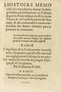
POSTEL, Guillaume
L’Histoire mémorable des expéditions depuys le deluge faictes par les Gauloys ou Fracoys depuis la Frace jusques en Asie, ou en Thrace & en l’orietale partie de l’Europe, & des commodites ou incommodités des divers chemins pour y parvenir & retourner. « L’Histoire mémorable des expéditions » de Postel
Édition originale «très rare et très recherchée» de cet abrégé des voyages entrepris jusqu’alors par les Gaulois en Asie et en Terre Sainte. Paris, 1552. Paris, Sebastian Nivelle, 1552. Petit in-16 de 55 ff. Sans l’Apologie de la Gaule prévue pour faire suite à ce texte. Relié en plein maroquin prune janséniste, dos à nerfs avec le titre doré, double filet doré sur les coupes, roulette dorée intérieure, tranches dorées. Reliure signée Chambolle-Duru. 112 x 78 mm.
Referencia librero : LCS-7618
|
|
|
Postpischl Daniele
Atlas of isoseismal maps of italian earthquakes. Progetto Finalizzato Geodinamica del Cnr
36x48 cm (album), rilegatura editoriale illustrata, titolo al piatto e dorso; p. 164, numerose carte geografiche, cronologia, descrizione ed intensità dei terremoti italiani dall'anno mille. Dedica a penna alla 1° c.b

|
|
|
Potonié, H
Illustrierte Flora von Nord- und Mitteldeutschland. [Von H. Potonié]. 2 Bände. - Band 1: Text. - Band 2: Atlas. Insgesamt 2 Bände / 5. Auflage.
Jena: Verlag von Gustav Fischer 1910. VI, 551; IV, 364 Seiten. Mit 150 Einzelabbildungen im Textband sowie zahlreichen Illustrationen im Atlas. 8° (17,5-22,5 cm). Flexible Orig.-Leinenbände. [Hardcover / fest gebunden].
Referencia librero : 147591

|
|
|
Poulain de Bossay P. A.
Atlas de géographie historique, dressé pour servir à l'intelligence de l'histoire ancienne
Louis Colas, libraire Relié 1833 In-4 (26,5 x 35 cm), exemplaire à relier, complet des 12 planches ; reliure fragile, dos manquant, plats très abîmés, à restaurer. Livraison a domicile (La Poste) ou en Mondial Relay sur simple demande.
Referencia librero : xs1650
|
|
|
POWELL, [Geo. May], compiler pub anonymously
The New Biblical Atlas and Scripture Gazetteer, with Descriptive Notices of The Tabernacle and the Temple
8vo [25 x 16 cm]; [iv], 101 pp, 9 hand colored maps including folding, hand colored plan, 2 engraved plates, other maps in text, additional hand colored folding map of Palestine added to front, not called for. original cloth, spine half lacking, signed by Wm P. Cresson, interior very good+, clean, with an additional folding colored map in printed wraps, inserted loose, inscribed to Cresson from the compiler (Powell). A picture of this book is available upon req A well illustrated work, this copy having two additional colored maps not in other copies
|
|
|
PRELCEC- GRADISER
1 CARTE DEPLIANTE EN COULEURS- YOUGOSLAVIE- CARTE TOURISTIQUE- DE DIMENSION 78x53 cm environ
CENTRE YOUGOSLAVE POUR LA PROMOTION DU TOURISME. 1973. In-Plano. Relié. Bon état, Couv. convenable, Dos satisfaisant, Intérieur frais. 1 CARTE DEPLIANTE EN COULEURS- DE DIMENSION 78x53 cm environ- avec légendes + notices explicatives et renseignements au verso de la carte. . . . Classification Dewey : 912-Atlas, cartes et plans
Referencia librero : R200052029
|
|
|
PREVOTEAU Raoul, DESIRY
CANTON DE TALMONT
1899 carte entoilée en couleurs (map in colours cloth-lined map), dimensions de la carte dépliée (Dimensions of the unfolded map - size in Inches) : 73 centimètres de largeur (width : 28.74) sur 55.5 de hauteur (height : 21.85), sans date imprimée (undated printed) - circa 1886 - à Paris Erhard Graveur et Imprimeur - 35 bis Denfert-Rochereau et 8 rue Nicole,
Referencia librero : 15736
|
|
|
PREVOTEAU Raoul, DESIRY
CANTON DE BEAUVOIR
1899 carte entoilée en couleurs (map in colours cloth-lined map), dimensions de la carte dépliée (Dimensions of the unfolded map - size in Inches) : 43.5 centimètres de largeur (width : 17.12) sur 55.5 de hauteur (height : 21.85), sans date imprimée (undated printed) - circa 1886 - à Paris Erhard Graveur et Imprimeur - 35 bis Denfert-Rochereau et 8 rue Nicole,
Referencia librero : 15738
|
|
|
PREVOTEAU Raoul, DESIRY
CANTON DE ROCHESERVIERE
1899 carte entoilée en couleurs (map in colours cloth-lined map), dimensions de la carte dépliée (Dimensions of the unfolded map - size in Inches) : 43.5 centimètres de largeur (width : 17.12) sur 55.5 de hauteur (height : 21.85), sans date imprimée (undated printed) - circa 1886 - à Paris Erhard Graveur et Imprimeur - 35 bis Denfert-Rochereau et 8 rue Nicole,
Referencia librero : 15739
|
|
|
PRESIDENCE DU CONSEIL
CARTE N°44 - AMERIQUE DU SUD - INDUSTRIES ET TRANSPORTS
LAFOSSE. Non daté. In-Plano. En feuillets. Bon état, Couv. convenable, Dos satisfaisant, Intérieur frais. CARTE N°44 En couleurs Echelle 1/ 10 000 000.. . . . Classification Dewey : 912-Atlas, cartes et plans
Referencia librero : R160205284
|
|
|
PREVOTEAU Raoul, DESIRY
carte du CANTON DE LA ROCHE-SUR-YON
1899 carte entoilée en couleurs (map in colours cloth-lined map), dimensions de la carte dépliée (Dimensions of the unfolded map - size in Inches) : 73 centimètres de largeur (width : 28.74) sur 55.5 de hauteur (height : 21.85), sans date imprimée (undated printed) - circa 1886 - à Paris Erhard Graveur et Imprimeur - 35 bis Denfert-Rochereau et 8 rue Nicole,
Referencia librero : 15737
|
|
|
PREGENT / GODDE / PAILLON
Forêt de Fontainebleu et ses environs.
GIRAD, BARRERE & THOMAS. 6ème édition. 1952. In-Plano. En feuillets. Bon état, Couv. convenable, Dos satisfaisant, Intérieur frais. Carte dépliante en couleurs d'environ 66/90 cm.. . . . Classification Dewey : 912-Atlas, cartes et plans
Referencia librero : RO80007121
|
|
|
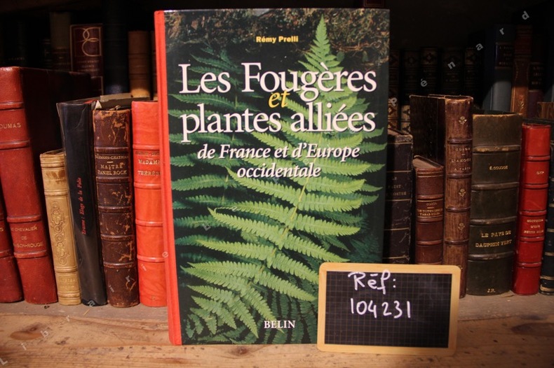
PRELLI, Rémy - Michel Boudrie (avec la collaboration de)
Les Fougères et plantes alliées de France et d'Europe occidentale
2001 Editions Belin - 2001 - 1 volume In-4 - Cartonnage souple éditeur illustré, dos toilé rouge - 430 pages - Illustrations en couleurs dans le texte
Referencia librero : 104231
|
|
|
PRESSOUYRE Sylvia
ROME AU FIL DU TEMPS. Atlas historique d'urbanisme et d'architecture.
1973 Boulogne (Hauts-de-Seine), éditions Joël Cuénot, collection des Atlas historiques d'urbanisme et d'architecture des grandes villes mondiales, 1973. Préface de Georges Vallet, directeur de l'École française de Rome. Comprenant une succession de plans à échelle constante, du site des origines à nos jours, avec en regard un texte explicatif et les photographies des principaux monuments. Grand in-8 de format à l'italienne, 25 x 22 cm., environ 180 pp. non numérotées, avec index in fine. Reliure de l'éditeur, pleine toile noisette imprimée en blanc, jaquette illustrée. Très bon état extérieur et intérieur.
Referencia librero : 18664

|
|
|
Prechtl, Hans, und Eduard Hölzel
Keysers Handatlas für Geographie und Geschichte / Red.: Hans Prechtl. Kartographie: Eduard Hölzel.
München : Keyser, 1967. XLIV, 96 S. 4°. OLwd mit Buntpräg. ohne SU.
Referencia librero : 29133
|
|
|
Prechtl, Maria
Der grosse Xenos-Weltatlas
Hamburg, XENOS Verlagsgesellschaft mb^H, 1996. 160 Seiten , 32 cm, Hardcover/Pappeinband
Referencia librero : 26180
|
|
|
Prechtl, Maria und Eigel Wiese
Der grosse Xenos Welt-Atlas
Hamburg, XENOS Verlagsgesellschaft mbH, ohne Angaben. 64, 159 Seiten , 32 cm , Hardcover/Pappeinband
Referencia librero : 49399

|
|
|
Prep. by E. NARDIN.
[MAP] A IV. Sinob. Black Sea shores, Pontus Euxinus.
Very Good French Original color map on cloth. Folded. Oblong atlas folio. (48 x 63 cm). Toponyms in German. It shows Sinop and Samsun city with their shores to 'Schwarzes Meer' and their hinterlands. [MAP] A IV. Sinob. Black Sea shores, Pontus Euxinus.
|
|
|
Prep. by IRFAN DAGDELEN.
Istanbul Büyüksehir Belediyesi Atatürk Kitapligi harita-haritalar katalogu. 4 volumes set.
Fine Turkish Paperback. 4to. (29 x 21 cm). In turkish. 4 volumes set: ([xiv], 333 p.; [4], [iv], 212 p.; [8], 200 p.; [8], 197 p.; 12 color plates, b/w ills.). Istanbul Büyüksehir Belediyesi Atatürk Kitapligi harita-haritalar katalogu. 4 volumes set. A very comprehensive map catalogue from Istanbul Municipality Ataturk Library Collection.
|
|
|
Prep. by MARTIN STERN, PASCAL LEBOUTEILLER, JEAN-FRANÇOIS Perouse.
Deux siecles de cartographie d'Istanbul et de son environment.= Istanbul ve çevresi üzerine iki yüzyil boyunca haritacilik. 07/03/2013 - 08/04/2013, Lycee Notre Dame de Sion, Istanbul. [Catalogue de l'exposition].
New English Paperback. Pbo. Oblong small 4to. In French and Turkish. 79 p. Color and b/w ills. "En relation avec le projet international , cette exposition a pour but d'interroger la representation cartographique de la ville et de son environnement a partir de l'exemple d'Istanbul. E s'appuyant sur une selection de cartes originales de l'Institut Français d'Etudes Anatoliennes (IFEA), il s'agira de saisir quelques aspects de cet entre-deux invisible qui relie le passe au present, et donne son identite a l'ancienne capitale Ottomane devenue megapole Europenne". Contents (Sommaire): Presentation generale de la cartographie. La carte comme convention. / La naissance d'une cartographie scientifique d'Istanbul, autour de Kauffer (1776-1844). / Autour des Kiepert (1844-1910). / Autour de la Grande Guerre (1910-1923). / 1923- 1960: Specialisation, municipalisation et vulgarisation.
|
|
|
Prep. by MURAT P. ERKEN.
Savaslarda haritacilar.
New Turkish Paperback. Demy 8vo. (21 x 14 cm). In Turkish. 158 p., b/w ills. Savaslarda haritacilar. A list and biographies of military cartographers of the Ottoman Empire and Turkish Republic from Mehmed Sevki to Mehmet Neset. It includes 150 short biographies with battles their participated. A fine reference for Turkish cartography.
|
|
|
Prep. by SÜKRÜ AKALIN et all.
Chart and map catalogue of Turkish Naval Museum.= Türk Deniz Müzesi harita katalogu.
Fine Fine English Original bdg. Dust wrapper. Oblong 4to. (28 x 28 cm). In English and Turkish. 437 p. Color ills. 1000 copies were printed. Chart and map catalogue of Turkish Naval Museum.= Türk Deniz Müzesi harita katalogu.
|
|
|
Preyssinger, Ludwig
Astronomischer Bilder-Atlas (Atlas-Mappe + Textheft).
Stuttgart, Wilhelm Nitzschke, o. J. (ca. 1850). Braune verschließbare Original-Ganzleinenmappe im Format 32 x 26 cm mit goldgeprägtem Deckeltitel sowie ornamentalen Blindprägungen. Außerdem zugehöriges Textheft (2. Aufl., 84 S., 1 Bl.). Sehr seltenes Atlaswerk des Augsburger Mathematikers und Kosmographen Ludwig Preyssinger, enthaltend 12 ganzseitige, überwiegend kolorierte lithographische Tafeln auf Karton, welche folgende Himmelskonstellationen abbilden: Taf. I: Die Central-Sonne und die Ansicht von der Fixsternenwelt. Taf. II: Himmels Karte mit den Sternen welche während des ganzen Jahres sichtbar sind. Taf. III: Darstellung des Sonnensystems, die Planeten mit ihren Bahnen, wie sie bis heute bekannt sind. Taf. IV: Vergleichende Darstellung der Grösse der Planeten. Taf. V: Die Sonne und verschiedene Erscheinungen derselben. Taf. VI: Der Mond durch das Fernrohr gesehen. Taf. VII: Transparente Darstellung der Mondphasen. Taf. VIII: Finsternisse (Mondfinsterniss - Sonnenfinsterniss; niedrige Fluth - Springfluth) Taf. IX: Ansicht von den Jahreszeiten nebst den Zeichen des Thierkreises. Taf X: Die Erde und ihre Atmosphäre. Taf. XI: Kometen und Aerolithen. Taf. XII: Mathemat. Geographische Begriffsversinnlichungen. Das Besondere an den kunstvoll gestalteten Tafeln sind unter anderem zahlreiche kleine oder größere, mit transparentem Buntpapier hinterlegte Ausstanzungen, so daß die betreffenden Areale, sobald die Tafeln ins Licht gehalten werden, aufleuchten und zum Beispiel die Himmels-Karte als leuchtender Sternenhimmel erscheint. Alle Tafeln mit erklärenden Texten. Mit enthalten ist ferner das zugehörige Textheft (Ergänzungs-Text zum Astronomischen Bilder-Atlas) mit den jeweiligen Tafeln zugeordneten astronomischen und kosmographischen Erläuterungen. Ludwig Preyssinger lehrte als Professor für Mathematik, Chemie, Physik, Kosmographie und Naturgeschichte am Königlichen Lyceum Augsburg und fungierte zugleich als Leiter des Augsburger Observatoriums.
Referencia librero : SB-17775

|
|
|
Prior (Robin) - Wilson (Trevor)
La Première Guerre mondiale. 1914-1918
Autrement, coll. « Atlas des guerres » 2001 In-4 cartonné 27 cm sur 21. Jaquette en assez bon état. 224 pages. Assez bon état d’occasion. Poids sans emballage : 1100 grammes.
Referencia librero : 43665
|
|
|
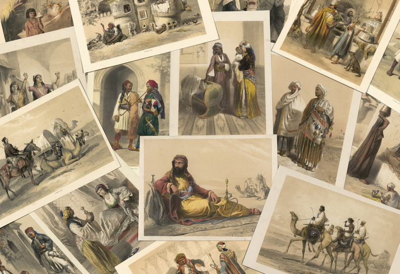
PRISSE D’AVENNES, Achille Constant Théodore Emile.
Oriental Album, characters, costumes, and modes of life in the valley of Nile. “The above is one of the most attractive books of Eastern Costume”.
“The influence of such a book on the mind is analogous to that of travelling: it extends our knowledge of different modes of existence”. London, James Madden, [1848]. 30 planches en couleurs en tirage à part plus 1 frontispice.
Referencia librero : LCS-18008
|
|
|
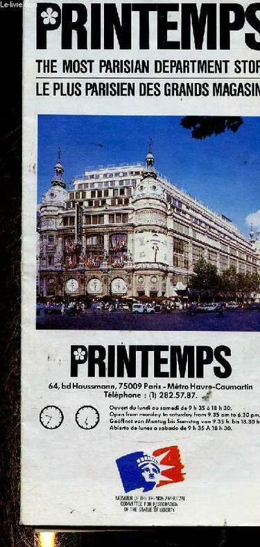
Printemps
Printemps, le plus Parisien des grands magasins + 1 carte de Paris
Printemps. Non daté. In-Folio. Broché. Bon état, Couv. convenable, Dos satisfaisant, Papier jauni. Une carte dépliante de Paris d'environ 55cm x 40cm. Nombreuses illustrations en couleur hors texte.. . . . Classification Dewey : 912-Atlas, cartes et plans
Referencia librero : RO30346545
|
|
 Recibir por correo electrónico
 Descargar en documento PDF
 Flujo RSS


