|
William A. Wellman director; Leopold Atlas Guy Endore Philip Stevenson screenwriters; Burgess Meredith Robert Mitchum Freddi
Story of G.I. Joe Original pressbook for the 1945 film
Beverly Hills CA: United Artists 1945. Vintage pressbook for the 1945 film. <br/><br/>Ernie Pyle Meredith is a journalist who enlists in the US Army during WWII. During his tour of duty in Africa and Italy he documents the effects of war on the human condition illuminating catastrophe the consequences of combat and new partnerships in times of crisis all from a first-person narrative. The real Pyle won a Pulitzer Prize in 1944 for his war correspondence. <br/><br/>Nominated for four Academy Awards. <br/><br/>14x 21 inches. 22 pages and a laid-in ad sheet saddle stapled in monochrome wrappers folded horizontally as issued. Very Good plus with spine rubbing a few spine chips and light foxing overall. United Artists unknown books
Référence libraire : 139955
|
|
|
William R. Wellnitz; Ronald M. Atlas
Microorganisms in Our World
Mosby Incorporated 1995. Paperback. Very Good. Disclaimer:A copy that has been read but remains in excellent condition. Pages are intact and are not marred by notes or highlighting but may contain a neat previous owner name. The spine remains undamaged. At ThriftBooks our motto is: Read More Spend Less.Dust jacket quality is not guaranteed. Mosby, Incorporated paperback
Référence libraire : G0815103360I4N00 ISBN : 0815103360 9780815103363
|
|
|
Willis-O'Connor, Col. H.; Macbeth, Madge; Baxter, Beverley; Allen, Robert Thomas; Frayne, Trent; Rosenfeld, Max; Montagu, The Hon. Ewen E.S.; Herbert, F.Hugh; Sloman, Fred; Fraser, Blair; Gilmour, Clyde;
Maclean's, Canada's National Magazine, June 1, 1953
56 pages. Features: Nice colour ad for the 1953 Mercury Monterey Custom Coupe inside front cover; Life with Five Governors-General (part 1 of 2) - the Bessboroughs, the Byngs and the Willingdons; The Binghams Came to Blows (fiction); Who will succeed Sir Winston Churchill?; How to sell a house (humour); Tom Thomson - The Rebel Painter of the Pine Woods - article with photos and colour reproduction of "The Pointers"; The Keys to the Car (fiction); Barrister Arthur Martin, QC - His clients never hang; The Corpse That Hoaxed the Nazis (conclusion) - the elaborate story of how the Allies tricked the Nazis into thinking Sardinia would be invaded, rather than Sicily; Fantastic 'mom and apple pie' General Motors of Canada centerfold colour illustration shows a 'Happy Community" - smiling pedestrians, sunny sky and roads full of GM of Canada cars; Gorgeous full-page colour ad for a yellow Oldsmobile '98' Holiday Coupe; uncommon ad for IEL (Industrial Engineering Limited) power chain saws; Interesting colour ad for Atlas tires on back cover shows the 61 license plates of the US states and Canadian provinces; and more. Clean and unmarked with moderate wear. A quality vintage copy. Book

|
|
|
Willkomms, Moritz Dr
Bilder-Atlas des Pflanzenreichs. Nach dem Englerschen System neu herausgegeben von Prof. E. Köhne.
Eßlingen, München Schreiber 1927. 6. Aufl./unveränd. Neudr. der vollst. umgearb. 5. Aufl. 4° XXII/183 S., m. 526 Pflanzenbild. a. 124 Farbendr.-Taf., 1 Schwarzdr.-Taf. u. 205 S. Text m. 100 Abb. OL. Guter Zust. 5
Référence libraire : 45677AB
|
|
|
Willoughby Jackie; Atlas Susan
The Healing Art of Beauty: Developing a Positive Self-Image Through Paramedic.
Keren Happuch Ltd 1989-12-01. Paperback. Good. pb 1989 cover has some shelf wear lite stain otherwise very nice clean text no underlining/highlighting binding tight SKU-A135 A small family business committed to BIG service! R2-4/19 Keren Happuch Ltd paperback
Référence libraire : 6E-Q76T-UTJE ISBN : 9990800669 9789990800661
|
|
|
Wilson, Colin
Kultstätten der Menschheit : [ein Atlas zu den heiligen Orten und mythischen Plätzen unserer Erde].
Münster : Premio, 2006. 191 S. zahlr. Ill., Kt. ; 31 cm. OPp., gebundene Ausgabe.
Référence libraire : 172094

|
|
|
Wilson, Peter W.F. (Ed.)
Atlas of Atherosclerosis: Risk Factors and Treatment (4 Bände im Schuber, komplett)
Philadelphia, Current Medicine 2002. 57; 86; 62; 82 S. (31x25,5 cm) Großformat, Broschierte Ausgabe im gemeinsamen Schuber
Référence libraire : 38124
|
|
|
WINKLER, Rainer
STOMATHERAPIE. - ATLAS UND LEITFADEN FÜR INTESTINALE STOMATA.
Stuttgart, Thieme, 1983. 104 s. Mit vielen, meist Farbigen illustrationen. Fester orig.-Einband mit Deckel- und Rückentitel; kl.-4to.
Référence libraire : 2039xkpv
|
|
|
Winter, Rudolf [Hrsg.]
Geo-Satellitenbild-Atlas Deutschland.
Berlin/Gütersloh/Leipzig/München/Potsdam/Stuttgart, RV-Verl, 1992. 3. Aufl. 36 cm. 239 S., Ill., graph. Darst., überwiegend Kt. Pp., OU., OU etwas berieben u. m. kl. Randläsuren, innen einige Ecken geknickt, sonst sauber u. gut erhalten. 3
Référence libraire : 57209AB
|
|
|
Winter, Rudolf [Hrsg.]
Geo-Satellitenbild-Atlas Deutschland. [8. Aufl.]
München ; Stuttgart : RV-Verl., [1998]. 239 S., Ill., graph. Darst., überw. Kt. OPp., gebundene Ausgabe, SU.
Référence libraire : 89645

|
|
|
Winter, Rudolf und Lothar Beckel
Satellitenbild Atlas Deutschland
München, Stuttgart, RV Reise- und Verkehrsverlag GmbH, 1996. 239 Seiten , 36 cm, Hardcover/Pappeinband
Référence libraire : 42835

|
|
|
Winter, Rudolf. Beckel, Lothar. Herausgeber
Satellitenbild Atlas Norddeutschlands.
Berlin, Gütersloh, u.a.., RV Verlag - Reise- und Verkehrsverlag., 1992. Herausgegeben von Rudolf Winter und Lothar Beckel in zusammenarbeit mit der Deutschen Forschungsanstalt für Luft- und Raumfahrt. 95(1)S. überwiegend Satellitenfotos, wenige Luftbildaufnahmen. Guter Zustand. 2°. OPappband.
Référence libraire : 039722
|
|
|
Winter, Rudolf. Beckel, Lothar. Herrausgeber
Geo Satellitenbildatlas Deutschland.
Berlin, Gütersloh u.a.., RV Reise und Verkehrsverlag., 1991. In Zusammenarbeit mit der Deutschen Forschungsanstalt für Luft- und Raumfahrt. 239(1) Seiten mit zahlreichen Satellitenkarten meist im Maßstab 1 : 200 000. Zustand: Aus einer Institutsbibliothek ausgeschieden, Titelblatt mit Bibliotheksstempel und Inventarnummer. 2°. OPappband.
Référence libraire : 051052
|
|
|
Winterson, Jeanette
Die Last der Welt. Der Mythos von Atlas und Herkules. Aus dem Engl. von Monika Schmalz
Berlin : Berlin-Verl., 2005. 109 Seiten; 21 cm Gebundene Ausgabe. Hardcover/Pappband mit Schutzumschlag.
Référence libraire : 41514

|
|
|
WISDOM Anthony ..//.. Anthony Wisdom.
Atlas en couleurs de Vénérologie.
Paris, Maloine, 1979, 1 volume, in-8 carré, cartonnage rigide éditeur, 349 p. 556 photographies couleur, index.
Référence libraire : 2680

|
|
|
Witzig Fritz
Munich et ses environs. Un nouveau guide avec 30 photos en couleur et 4 schémas. Un plan des parkings, un plan du Métro et des Tramways
Witzig. 1972. In-12. Broché. Bon état, Couv. convenable, Dos satisfaisant, Papier jauni. 98 pages. Nombreuses planches d'illustrations en couleur, hors texte.. . . . Classification Dewey : 912-Atlas, cartes et plans
Référence libraire : RO30342234

|
|
|
WITH COMPLIMENTS OF THE MINISTRY OF INFORMATION, KINGDOM OF SAUDI ARABIA.
Saudi Arabian map: The Kingdom of the Saudi Arabia.= Harita al-Mamlakat al-Arabiyya al-Saudiyya.
Very Good English Original folded color map. Oblong atlas folio. (60x91 cm). Bilingual in English and Arabic. Arabic map and texts with b/w photographs of some views from Saudi Arabia and English map and texts with b/w photos of Jeddah, Riyadh and Dhahran airports with legends and "distances in kilometers". It shows a very detailed landscape of entire Arabian Peninsula including Saudi Arabia, Aden, Oman, Muscat Qatar, Trucial Coast, Nafud, Dahna, Rub' Al-Khali, Najran, Asir, Yemen, Ramlat As Sab'atayn, Dhofar, Al Mahrah, Hadhramaut, Kuwait, Neutral Zone, and others.
|
|
|
Wittke, Anne- Maria. Olshausen, Eckart, Szydlak, Richard
Historischer Atlas der antiken Welt.
Stuttgart, Weimar., Verlag J. B. Metzler., 2012. Ungekürzte Sonderausgabe des 2007 als Band 3 der Reihe "Der neue Pauly" , Supplemente" erschienen Werks. XIX, 308 Seiten mit zahlreichen Karten und Texten. Guter Zustand. 4°. H OPappband im Schuber.
Référence libraire : 062077
|
|
|
Wittke, Anne-Maria/ Olshausen, Eckart/ Szydlak, Richard
Historischer Atlas der antiken Welt. (Der neue Pauly, Supplemente Band. 3).
Stuttgart Metzler (Liz. Darmstadt: WBG) um 2012. XIX, 308 S., 48 s/w Abb., 168 farb. Abb., 168 farbige Karten; 77 sw-Karten und Tabellen, Stammtaf. Gr 4° Kart.mS. *verlagsneu*.
Référence libraire : 229465

|
|
|
WOERL, J. (Joseph Edmund).:
(Atlas) Karte der Schweiz. Lithographie von B. Herder in Freiburg im Breisgau.
(Freiburg i.Br., Herder), 1834-35), Quer-Gr.-Folio, lithographierter Titel und 19 lithographierte Karten, mit Rotdruck und Handkolorit, Papier gebräunt und stockfleckig, Randriss bei 2 Karten, Halblederband, Deckel mit Marmorpapier bezogen, etwas berieben.
Référence libraire : 7222aaf
|
|
|
Wolff, Christian
Elfha-Stadtatlas Hamburg. [Werbedruck Schreyer Bürotechnik Hamburg].
[Hamburg], Cram, de Gruyter, o.J.[1962]. Kunststoffeinband, gr-8°, 46 S. Straßenverzeichnis, 13 gefaltete farbige Tafeln mit 24 Karten, 1 gefaltete s/w Tafel mit einer Luftbildaufnahme und 1 Umgebungsplan, 1 Innenstadtplan; -etwas berieben, gutes Exemplar.
Référence libraire : 14435
|
|
|
Wolff, Hans
America. Das frühe Bild der Neuen Welt. Ausstellung der Bayerischen Staatsbibliothek.
München, Prestel-Verlag, 1992. 192 S. Mit zahlr. (tls. farb.) Illustrationen. Quer-4°. Orig.-Broschur mit farb. Deckelillustration.
Référence libraire : 25358

|
|
|
Wolff, Hans
Cartographia Bavariae. Bayern im Bild der Karte. [Ausstellung 17. Mai - 29. Juli 1988]. Mit Beitr. von Gerfried Appelt, Rüdiger Finsterwalder und Uta Lindgren. (= Bayerische Staatsbibliothek, Ausstellungskataloge, Bd. 44).
Weißenhorn in Bayern, A. Konrad Verlag, 1988. 431 S. Mit 309 (tls. farb.) Illustrationen. Quer-4°. Orig.-Broschur mit farb. Deckelillustration.
Référence libraire : 25352

|
|
|
Wolff, Hans (Hg.)
Vierhundert [400] Jahre Mercator. Vierhundert [400] Jahre Atlas. "Die ganze Welt zwischen zwei Buchdeckeln". Eine Geschichte der Atlanten. [Zum 400. Todestag Gerhard Mercators anläßlich einer Ausstellung der Bayerischen Staatsbibliothek vom 5. April 1995 bis 1. Juli 1995]. Herausgegeben im Auftrag der Bayerischen Staatsbibliothek (= Bayerische Staatsbibliothek, Ausstellungskataloge, Bd. 65).
Weißenhorn in Bayern, A. Konrad Verlag, 1995. Mit zahlr. (tls. farb.) illustrationen auf Tafeln u. im Text. 382 S., 1 Bl. Quer-4°. Kartonierter (flexibler) Orig.-Einband mit farb. Deckelillustration.
Référence libraire : 25350

|
|
|
Wolff, Hans (u.a.)
Philipp Apian und die Kartographie der Renaissance.
Weissenhorn, Anton H. Konrad, 1989. 237 S. Mit 175, teils farbigen Abb. (= Bayerische Staatsbibliothek: Ausstellungskataloge, 50). Quer-Gr.-8vo (23 x 27 cm). Engl. Brosch.
Référence libraire : 94085
|
|
|
WOLVERTON ATLAS OF MONMOUTH COUNTY
MATAWAN 1889 MAP
1889. WOLVERTON ATLAS OF MONMOUTH COUNTY. MATAWAN 1889 MAP. A 15-inch by 22-inch hand-colored map showing Matawan depicting the area from the Matawan Creek to Atlantic Avenue. $100.00. <br/><br/> unknown
Référence libraire : 26247

|
|
|
WOLVERTON ATLAS OF MONMOUTH COUNTY
MATAWAN 1889 MAP
1889. WOLVERTON ATLAS OF MONMOUTH COUNTY. MATAWAN 1889 MAP. A 15-inch by 22-inch hand-colored map showing Matawan depicting the area from the Matawan Creek to Atlantic Avenue. $100.00. <br/><br/> unknown books
Référence libraire : 26247
|
|
|
WOLVERTON'S ATLAS OF MONMOUTH COUNTY
EATONTOWN MAP: 1889
1889. WOLVERTON'S ATLAS OF MONMOUTH COUNTY. EATONTOWN MAP 1889. A 20-inch by 30-inch hand-colored map of Eatontown also showing Monmouth Park and Oceanport. Probably one of the best early maps of Eatontown ever made. $125.00. <br/><br/> unknown
Référence libraire : 26237

|
|
|
WOLVERTON'S ATLAS OF MONMOUTH COUNTY
HOWELL TOWNSHIP: 1889 MAP
1889. WOLVERTON'S ATLAS OF MONMOUTH COUNTY. HOWELL TOWNSHIP 1889 MAP. A 20-inch by 30-inch hand-colored map of Howell Township showing West Farms Fairfield Farmingdale Jerseyville Turkey Blue Ball Greenville Runyons Bethel and Squankum. $125.00. <br/><br/> unknown
Référence libraire : 26242

|
|
|
WOLVERTON'S ATLAS OF MONMOUTH COUNTY
MILLSTONE TOWNSHIP MAP 1889
1889. WOLVERTON'S ATLAS OF MONMOUTH COUNTY. MILLSTONE TOWNSHIP 1889 MAP. A 20-inch by 30-inch hand-colored map of Millstone Township also showing the Navesink section of Middletown Township. $125.00. <br/><br/> unknown
Référence libraire : 26238

|
|
|
WOLVERTON'S ATLAS OF MONMOUTH COUNTY
RARITAN 1889 MAP
1889. WOLVERTON'S ATLAS OF MONMOUTH COUNTY. RARITAN MAP 1889. A 15-inch by 18-inch hand-colored map of Raritan showing the Union Keyport Bethany Centerville and Granville school districts. $50.00. <br/><br/> unknown
Référence libraire : 26248

|
|
|
WOLVERTON'S ATLAS OF MONMOUTH COUNTY
EATONTOWN MAP: 1889
1889. WOLVERTON'S ATLAS OF MONMOUTH COUNTY. EATONTOWN MAP 1889. A 20-inch by 30-inch hand-colored map of Eatontown also showing Monmouth Park and Oceanport. Probably one of the best early maps of Eatontown ever made. $150.00. unknown books
Référence libraire : 26237
|
|
|
WOLVERTON'S ATLAS OF MONMOUTH COUNTY
HOWELL TOWNSHIP: 1889 MAP
1889. WOLVERTON'S ATLAS OF MONMOUTH COUNTY. HOWELL TOWNSHIP 1889 MAP. A 20-inch by 30-inch hand-colored map of Howell Township showing West Farms Fairfield Farmingdale Jerseyville Turkey Blue Ball Greenville Runyons Bethel and Squankum. $150.00. unknown books
Référence libraire : 26242
|
|
|
WOLVERTON'S ATLAS OF MONMOUTH COUNTY
MILLSTONE TOWNSHIP MAP 1889
1889. WOLVERTON'S ATLAS OF MONMOUTH COUNTY. MILLSTONE TOWNSHIP 1889 MAP. A 20-inch by 30-inch hand-colored map of Millstone Township also showing the Navesink section of Middletown Township. $150.00. unknown books
Référence libraire : 26238
|
|
|
WOLVERTON'S ATLAS OF MONMOUTH COUNTY
RARITAN 1889 MAP
1889. WOLVERTON'S ATLAS OF MONMOUTH COUNTY. RARITAN MAP 1889. A 15-inch by 18-inch hand-colored map of Raritan showing the Union Keyport Bethany Centerville and Granville school districts. $50.00. <br/><br/> unknown books
Référence libraire : 26248
|
|
|
WOOD JENNY
ATLAS DES PAYS DU MONDE
CASTERMAN. 1994. In-Folio. Relié. Etat d'usage, Couv. convenable, Coiffe en tête abîmée, Intérieur frais. 95 pages augmentées de nombreuses illustrations et photos en couleur in et hors texte. . . . Classification Dewey : 912-Atlas, cartes et plans
Référence libraire : R160203801
|
|
|
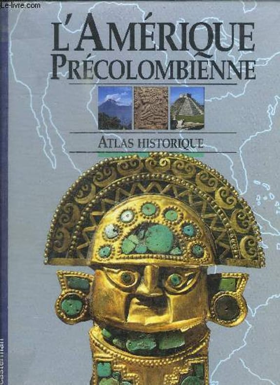
WOOD MARION
L'AMERIQUE PRECOLOMBIENNE - ATLAS HISTORIQUE
CASTERMAN. 1991. In-4. Relié. Bon état, Couv. convenable, Dos satisfaisant, Intérieur frais. 96 pages. Nombreuses illustrations en couleur dans et hors texte.. . . . Classification Dewey : 912-Atlas, cartes et plans
Référence libraire : RO30133676
|
|
|
WOOD (Nicholson)
Traité pratique des chemins de fer, traduit de l'ouvrage anglais (deuxième édition). Avec des notes et additions par F. de Montricher et E. de Franqueville, et H. de Ruolz.
Paris, Carillan-Goeury, 1834, 2 volumes in-4, XII-306pp.-1f, titre et 14 planches sur 2 pages, relié demi veau époque , dos lisse avec auteur , titre et tomaison, frottements aux dos , début de fentes à l’atlas, manque de matière, un planche déchirée sans manque.
Référence libraire : PHO-1478
|
|
|
WOOLMAN AND ROSE ATLAS OF THE NEW JERSEY COAST
ASBURY PARK: GRAND AVENUE HOUSE
1878. WOOLMAN AND ROSE ATLAS OF THE NEW JERSEY COAST. ASBURY PARK 1878. THE GRAND AVENUE HOUSE. An 11.5-inch by 14-inch hand-colored print showing the Grand Avenue House Property of Sill & Ripley in Asbury Park. $125.00. <br/><br/> unknown
Référence libraire : 31435

|
|
|
WOOLMAN AND ROSE ATLAS OF THE NEW JERSEY COAST
ASBURY PARK: PRINCETON LUMBER YARD
1878. WOOLMAN AND ROSE ATLAS OF THE NEW JERSEY COAST. ASBURY PARK 1878. An original print not a reproduction showing the Branch yard of Princeton Lumber and Improvement Co. Hand-colored. $85.00. <br/><br/> unknown
Référence libraire : 26179

|
|
|
WOOLMAN AND ROSE ATLAS OF THE NEW JERSEY COAST
ASBURY PARK: COLEMAN HOUSE
1878. WOOLMAN AND ROSE ATLAS OF THE NEW JERSEY COAST. ASBURY PARK 1878. THE COLEMAN HOUSE. An 11.5-inch by 14-inch hand-colored engraving depicting the Coleman House hotel and its surroundings in Asbury Park including boating on Wesley Lake. $125.00. <br/><br/> unknown
Référence libraire : 27484

|
|
|
WOOLMAN AND ROSE ATLAS OF THE NEW JERSEY COAST
ATLANTIC CITY: COLONNADE HOUSE
1878. WOOLMAN AND ROSE ATLAS OF THE NEW JERSEY COAST. ATLANTIC CITY 1878. COLONNADE HOUSE. An 11.5-inch by 14-inch print of the Colonnade House in Atlantic City J. Henry Hayes Propr. $45.00. <br/><br/> unknown
Référence libraire : 26671

|
|
|
WOOLMAN AND ROSE ATLAS OF THE NEW JERSEY COAST
ATLANTIC CITY: GERMANTOWN COTTAGE
1878. WOOLMAN AND ROSE ATLAS OF THE NEW JERSEY COAST. ATLANTIC CITY 1878. GERMANTOWN COTTAGE. An 11.5-inch by 14-inch print depicting a view of the Germantown Cottage Atlantic City J.W. Donnelly Prop. $45.00. <br/><br/> unknown
Référence libraire : 26670

|
|
|
WOOLMAN AND ROSE ATLAS OF THE NEW JERSEY COAST
ATLANTIC CITY: HADDON HOUSE
1878. WOOLMAN AND ROSE ATLAS OF THE NEW JERSEY COAST. ATLANTIC CITY 1878. HADDON HOUSE. An 11.5-inch by 14-inch print which is devided into three sections. The upper section depicts a view of the Haddon House Lippincott & Stokes Propr's foot of N. Carolina Ave Atlantic City. The lower half depicts the Cottage Residence of Robt. Kaughn Atlantic City & the Residence of Eliza P. Gurney in Atlantic City. $45.00. <br/><br/> unknown
Référence libraire : 26669

|
|
|
WOOLMAN AND ROSE ATLAS OF THE NEW JERSEY COAST
ATLANTIC CITY: SEA SIDE HOUSE
1878. WOOLMAN AND ROSE ATLAS OF THE NEW JERSEY COAST. ATLANTIC CITY SEADISE HOUSE 1878. An 11.5-inch by 14-inch print with the bottom half depicting a frontal view of the Sea Side House Atlantic City Chas. Evans Pror. The top half of the print is devoted to the Mongrief House in Jacksonville Florida. $45.00. <br/><br/> unknown
Référence libraire : 26668

|
|
|
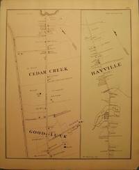
WOOLMAN AND ROSE ATLAS OF THE NEW JERSEY COAST
BAYVILLE
1878. WOOLMAN AND ROSE ATLAS OF THE NEW JERSEY COAST. BAYVILLE 1878. An 11-inch by 14-inch hand-colored map showing parts of Bayville Cedar Creek and Good Luck. $45.00. <br/><br/> unknown
Référence libraire : 26652
|
|
|
WOOLMAN AND ROSE ATLAS OF THE NEW JERSEY COAST
BELMAR/ OCEAN BEACH: COLUMBIA HOUSE
1878. WOOLMAN AND ROSE ATLAS OF THE NEW JERSEY COAST. BELMAR/ OCEAN BEACH: COLUMBIA HOUSE 1878. A print showing the Columbia House in Ocean Beach. Ocean Beach is now known as Belmar. $50.00. <br/><br/> unknown
Référence libraire : 26198

|
|
|
WOOLMAN AND ROSE ATLAS OF THE NEW JERSEY COAST
BELMAR/ OCEAN BEACH: FIFTH AVENUE HOUSE
1878. WOOLMAN AND ROSE ATLAS OF THE NEW JERSEY COAST. BELMAR/ OCEAN BEACH 1878. A print showing the 5th Avenue House in Ocean Beach. Property of J.L.Hoppock. Ocean Beach is now known as Belmar. $45.00. <br/><br/> unknown
Référence libraire : 26196

|
|
|
WOOLMAN AND ROSE ATLAS OF THE NEW JERSEY COAST
BELMAR/ OCEAN BEACH: COLUMBIA HOUSE
1878. WOOLMAN AND ROSE ATLAS OF THE NEW JERSEY COAST. BELMAR/ OCEAN BEACH 1878. COLUMBIA HOUSE. An 11-inch by 14-inch hand-colored print showing the Columbia House a number of bathers and pedestrians and several horse and buggy or wagon teams. Ocean Beach is now known as Belmar. $100.00. <br/><br/> unknown
Référence libraire : 29302

|
|
|
WOOLMAN AND ROSE ATLAS OF THE NEW JERSEY COAST
BELMAR/ OCEAN BEACH: NEPTUNE HOUSE
1878. WOOLMAN AND ROSE ATLAS OF THE NEW JERSEY COAST. BELMAR/ OCEAN BEACH 1878. NEPTUNE HOUSE. A print of the Neptune House in Ocean Beach. Property of J.L. Hoppock. Ocean Beach is now known as Belmar. $45.00. <br/><br/> unknown
Référence libraire : 26199

|
|
 Recevoir par e-mail
 Télécharger en PDF
 Flux RSS


