|
COLLECTIF
"San Sebastian y la Provenci de Guipuzcoa. Brochure dépliante """""
CENTRO DE ATRACCION Y TURISMO. Non daté. In-12. En feuillets. Bon état, Couv. convenable, Dos satisfaisant, Intérieur frais. Plan dépliant en couleurs, de 60 x 42 cm.. . . . Classification Dewey : 912-Atlas, cartes et plans
Referencia librero : RO80151470
|
|
|
Collectif
"Turquie, carte générale au 1 : 750 000 avec plans de ville - ""Les spéciales de l'IGN/Europe"" 3615 IGN - 1re édition"
Institut Géographique National/Marco Polo. 1994. In-Plano. En feuillets. Bon état, Couv. convenable, Dos satisfaisant, Intérieur frais. Carte dépliante en couleurs (100 x 126 cm environ).. . . . Classification Dewey : 912-Atlas, cartes et plans
Referencia librero : R300301304

|
|
|
COLLECTIF
"UN PLAN DEPLIANT COULEUR : ""ROAD MAP OF MALAYSIA."
MINISTRY OF CULTURE AND TOURISM. NON DATE. In-Plano. En feuillets. Bon état, Couv. convenable, Dos satisfaisant, Intérieur frais. 1 CARTE DEPLIANTE EN COULEUR.. . . . Classification Dewey : 912-Atlas, cartes et plans
Referencia librero : R320110824
|
|
|
Collectif
"Vosges (Collection ""Cartes départementales"") Echelle 1:200000"
Hachette & cie. Non daté.. In-12. Broché. Etat d'usage, Plats abîmés, Dos fané, Quelques rousseurs. 1 carte colorée dépliante (échelle 1:200000). Coins frottés. Rousseurs.. . . . Classification Dewey : 912-Atlas, cartes et plans
Referencia librero : RO30371159

|
|
|
COLLECTIF
'GEOGRAPHIA', MAP OF THE BRITISH ISLES
Geographia Ltd.. Non daté. In-Plano. En feuillets. Bon état, Couv. convenable, Dos satisfaisant, Intérieur frais. Grande carte dépliable en couleur d'env. 100/75 cm.. . . . Classification Dewey : 912-Atlas, cartes et plans
Referencia librero : RO40217221
|
|
|
COLLECTIF
'MON ATLAS', FASC. II, L'EUROPE MOINS LA FRANCE
Chocolateries Kwatta et Cida. Non daté. In-4. Relié. Etat d'usage, Couv. légèrement passée, Dos satisfaisant, Quelques rousseurs. Paginé de 41 à 80. Illustré de nombreuses cartes en couleur. Vignettes en regard des cartes manquantes. Dos muet. Feuillet 57-58 déchiré avec partie détachée.. . . . Classification Dewey : 912-Atlas, cartes et plans
Referencia librero : RO40231032
|
|
|
COLLECTIF
1 CARTE - DOVER AND CALAIS TO ORFORDNESS ANS SCHEVENINGEN COMPILED FROM THE LATEST ADMIRALTY & FOREIGN GOVERNMENT SURVENS
PUBLISHED AT THE ADMIRALTY. 1913. In-Folio. En feuillets. Etat d'usage, Couv. convenable, Dos satisfaisant, Intérieur frais. 1 carte maritime dépliante de 68 x 108 cm, en anglais, gravée en noir et blanc par davies et Company. Tâchée.. . . . Classification Dewey : 912-Atlas, cartes et plans
Referencia librero : RO30055048

|
|
|
COLLECTIF
1 CARTE DE LA POLOGNE EN COULEUR - TOURIST MAP
POLSKA - THE NATURAL CHOICE. 1996. In-Folio. En feuillets. Bon état, Couv. convenable, Dos satisfaisant, Intérieur frais. 1 carte en couleurs dépliante de 34 x 75,5 cm. Explications au verso, en anglais.. . . . Classification Dewey : 912-Atlas, cartes et plans
Referencia librero : RO30062707
|
|
|
COLLECTIF
1 CARTE - ECOLE DE PERFECTIONNEMENT DES OFFICIERS DE RESERVE DE LA PEPINIERE - ANNEE D'INSTRUCTION 1928-1929
IMP. AU SERVICE GEOGRAPHIQUE DE L'ARMEE. 1928. In-Folio. En feuillets. Bon état, Couv. convenable, Dos satisfaisant, Intérieur frais. 1 carte dépliante, en noir et blanc de 68 x 53,5 cm représentant l'école de perfectonnemen des officiers de réserve de la pépinière. Echelle 1/20000. Petites déchirures au niveau des plis.. . . . Classification Dewey : 912-Atlas, cartes et plans
Referencia librero : RO30065033

|
|
|
COLLECTIF
1 CARTE DE FRANCE ROUTIERE
GENERAL MOTORS FRANCE. non daté. In-Plano. En feuillets. Etat d'usage, Couv. défraîchie, Dos satisfaisant, Intérieur frais. 1 cartes dépliante de 75 x 95 cm en couleurs avec toutes les concessions Général motors.. . . . Classification Dewey : 912-Atlas, cartes et plans
Referencia librero : RO30069778

|
|
|
COLLECTIF
1 CARTE DE SAUGUES
EDITION 3. Dec 1954. In-Folio. En feuillets. Bon état, Couv. convenable, Dos satisfaisant, Intérieur frais. 1 carte dépliante en couleurs de 36.5 x 56 cm. Carte au 50.000°. Série M 761, feuille XXVI-36.. . . . Classification Dewey : 912-Atlas, cartes et plans
Referencia librero : RO30077446

|
|
|
COLLECTIF
1 CARTE DE MASSIAC N°S 5-6
***. non daté. In-Plano. En feuillets. Bon état, Couv. convenable, Dos satisfaisant, Intérieur frais. 1 carte dépliante en couleurs de 86 x 70 cm. Carte au 1/20000.. . . . Classification Dewey : 912-Atlas, cartes et plans
Referencia librero : RO30077447

|
|
|
COLLECTIF
1 CARTE DE LANGEAC
EDITION 3. Dec 1954. In-Plano. En feuillets. Bon état, Couv. convenable, Dos satisfaisant, Intérieur frais. 1 carte dépliante en couleurs de 74 x 56 cm. Carte au 50.000°. Série M 761, feuille XXVI-35.. . . . Classification Dewey : 912-Atlas, cartes et plans
Referencia librero : RO30077448

|
|
|
COLLECTIF
1 CARTE DE MASSIAC N°S 1-2
***. non daté. In-Plano. En feuillets. Bon état, Couv. convenable, Dos satisfaisant, Intérieur frais. 1 carte dépliante en couleurs de 86 x 70 cm. Carte au 1/20000.. . . . Classification Dewey : 912-Atlas, cartes et plans
Referencia librero : RO30077449

|
|
|
COLLECTIF
1 CARTE DEPLIANTE EN COULEURS : CHARTRES - FEUILLLE N°24
***. non daté. In-Folio. En feuillets. Bon état, Couv. convenable, Dos satisfaisant, Intérieur frais. 1 carte en couleurs dépliante. Carte de france et frontières au 200.000°. Type 1912 / 1942.. . . . Classification Dewey : 912-Atlas, cartes et plans
Referencia librero : RO30096669
|
|
|
COLLECTIF
1 CARTE DEPLIANTE EN NOIR ET BLANC : CANAL DE BRISTOL
***. non daté. In-Plano. En feuillets. Bon état, Couv. convenable, Dos satisfaisant, Intérieur frais. 1 carte en noir et blanc, dépliante de 106 x 74 cm représentant le Canal de Bristol : Cote ouest Angleterre.. . . . Classification Dewey : 912-Atlas, cartes et plans
Referencia librero : RO30086372

|
|
|
COLLECTIF
1 CARTE EN COULEURS ENTOILEE - ESPAGNE
***. non daté. In-Plano. En feuillets. Bon état, Couv. convenable, Dos satisfaisant, Intérieur frais. 1 carte en couleurs entoilée, dépliante de 58.5 x 62,5 cm représentant l'espagne. Carte en allemand.. . . . Classification Dewey : 912-Atlas, cartes et plans
Referencia librero : RO30086373

|
|
|
COLLECTIF
1 CARTE EN COULEURS ENTOILEE : ITALIE
***. non daté. In-Plano. En feuillets. Bon état, Couv. convenable, Dos satisfaisant, Intérieur frais. 1 carte en couleurs entoilée, dépliante de 50,5 x 62 cm représentant l'italie. Carte en allemand.. . . . Classification Dewey : 912-Atlas, cartes et plans
Referencia librero : RO30086374

|
|
|
COLLECTIF
1 CARTE EN COULEURS ENTOILEE : ALLEMAGNE
***. non daté. In-Plano. En feuillets. Bon état, Couv. convenable, Dos satisfaisant, Intérieur frais. 1 carte en couleurs entoilée, dépliante de 63 x 55,5 cm représentant l'Allemagne. Carte en allemand.. . . . Classification Dewey : 912-Atlas, cartes et plans
Referencia librero : RO30086375

|
|
|
COLLECTIF
1 CARTE EN COULEURS ENTOILEE : FRANCE
***. non daté. In-Plano. En feuillets. Bon état, Couv. convenable, Dos satisfaisant, Intérieur frais. 1 carte en couleurs entoilée, dépliante de 68 x 69 cm représentant la France. Carte en allemand.. . . . Classification Dewey : 912-Atlas, cartes et plans
Referencia librero : RO30086376

|
|
|
COLLECTIF
1 CARTE EN COULEURS ENTOILEE : MER DU NORD
***. non daté. In-Plano. En feuillets. Bon état, Couv. convenable, Dos satisfaisant, Intérieur frais. 1 carte en coulurs entoilée, dépliante de 69 x 34 cm représentant la mer du nord. Carte en allemand.. . . . Classification Dewey : 912-Atlas, cartes et plans
Referencia librero : RO30086377
|
|
|
COLLECTIF
1 CARTE ENTOILEE DE LIBOURNE
LIBRAIRIE ET PAPETERIE FERET ET FILS. 1856. In-12. Broché. Bon état, Couv. convenable, Dos satisfaisant, Intérieur frais. 1 carte entoilée de 88 x 61 cm, dépliante, en noir et blanc. Echelle 1/80000.. . . . Classification Dewey : 912-Atlas, cartes et plans
Referencia librero : RO30086406

|
|
|
COLLECTIF
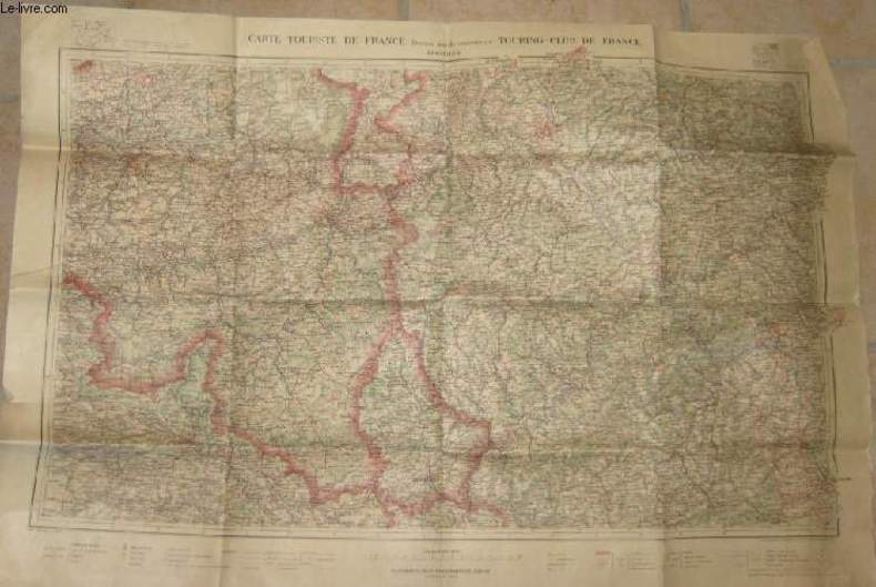
1 CARTE TOURISTIQUE DE FRANCE DRESSEE AVEC LE CONCOURS DU TOURING CLUB DE FRANCE
HENRY BARRERE EDITEUR. 1904 rev. 1914. In-12. Broché. Bon état, Couv. convenable, Dos satisfaisant, Intérieur frais. 1 carte dépliante en couleurs de 91 x 62 cm. Echelle 1 : 400000°.. . . . Classification Dewey : 912-Atlas, cartes et plans
Referencia librero : RO30090463
|
|
|
COLLECTIF
1 CARTE MARITIME EN COULEURS - COTE NORD DE FRANCE - DES ROCHES DE PORTSALL AU PLATEAU DES ROCHES DOUVRES - CARTE N°6330 / INT1707
SHOM - SERVICE HYDROGRAPHIQUE ET OCEANOGRAPHIQUE DE LA MARINE. 1985. In-Plano. En feuillets. Bon état, Couv. convenable, Dos satisfaisant, Intérieur frais. 1 carte en couleurs de 119 x 84 cm. Echelle 1/150000 (51° 00').. . . . Classification Dewey : 912-Atlas, cartes et plans
Referencia librero : RO30092575
|
|
|
COLLECTIF
1 CARTE MARITIME EN COULEURS - ILE D'YEU
SHOM - SERVICE HYDROGRAPHIQUE ET OCEANOGRAPHIQUE DE LA MARINE - 2° EDITION. 1982. In-Plano. En feuillets. Bon état, Couv. convenable, Dos satisfaisant, Intérieur frais. 1 carte en couleurs de 52.5 x 75 cm.. . . . Classification Dewey : 912-Atlas, cartes et plans
Referencia librero : RO30092563
|
|
|
COLLECTIF
1 CARTE MARITIME EN COULEURS - DU CAP FERAT A COPA MELE - CARTE N°7017
SHOM - SERVICE HYDROGRAPHIQUE ET OCEANOGRAPHIQUE DE LA MARINE. 1986. In-Plano. En feuillets. Bon état, Couv. convenable, Dos satisfaisant, Intérieur frais. 1 carte en couleurs de 83,5 x 60 cm. Echelle 1/100000.. . . . Classification Dewey : 912-Atlas, cartes et plans
Referencia librero : RO30092564
|
|
|
COLLECTIF
1 CARTE MARITIME EN COULEURS - COTE OUEST DE FRANCE - DE LA POINTE DE ST MATHIEU A AUDIERNE - CARTE N°6609
SHOM - SERVICE HYDROGRAPHIQUE ET OCEANOGRAPHIQUE DE LA MARINE. 1983. In-Plano. En feuillets. Bon état, Couv. convenable, Dos satisfaisant, Intérieur frais. 1 carte en couleurs de 84 x 117 cm. Echelle 1/45 8000 (48° 10').. . . . Classification Dewey : 912-Atlas, cartes et plans
Referencia librero : RO30092566
|
|
|
COLLECTIF
1 CARTE MARITIME EN COULEURS - COTE SUD DE FRANCE - GOLFE DE PORT DE FOS (PORT DE MARSEILLE) - CARTE N°6684
SHOM - SERVICE HYDROGRAPHIQUE ET OCEANOGRAPHIQUE DE LA MARINE. 1986. In-Plano. En feuillets. Bon état, Couv. convenable, Dos satisfaisant, Intérieur frais. 1 carte en couleurs de 118 x 84 cm. Echelle 1/25000.. . . . Classification Dewey : 912-Atlas, cartes et plans
Referencia librero : RO30092574
|
|
|
COLLECTIF
1 CARTE MARITIME EN COULEURS - OCEAN ATLANTIQUE COTE OUEST DE FRANCE - ANSE DE BENODET PORTS DE BENODET ET DE LOCTUDY - CARTEN°6649
SHOM - SERVICE HYDROGRAPHIQUE ET OCEANOGRAPHIQUE DE LA MARINE. 1982. In-Plano. En feuillets. Bon état, Couv. convenable, Dos satisfaisant, Intérieur frais. 1 carte en couleurs de 84 x 59 cm. Echelle 1/15000.. . . . Classification Dewey : 912-Atlas, cartes et plans
Referencia librero : RO30092579
|
|
|
COLLECTIF
1 CARTE MARITIME EN COULEURS - MER MEDITERRANNEE - COTE DU DE FRANCE - PARAGES DE TOULON GOLFE DE GIENS - CARTE N°5175
SHOM - SERVICE HYDROGRAPHIQUE ET OCEANOGRAPHIQUE DE LA MARINE - 7° EDITION. 1986. In-Plano. En feuillets. Bon état, Couv. convenable, Dos satisfaisant, Intérieur frais. 1 carte en couleurs de 106 x 75 cm. Echelle 1/25000(46° 06').. . . . Classification Dewey : 912-Atlas, cartes et plans
Referencia librero : RO30092581
|
|
|
COLLECTIF
1 CARTE MARITIME EN COULEURS - CARTE SUD DE FRANCE - DE SAINTE MARIE DE LA MER A PORT SAINT LOUIS DU RHONE - CARTE N°6693
SHOM - SERVICE HYDROGRAPHIQUE ET OCEANOGRAPHIQUE DE LA MARINE - 2° EDITON. 1985. In-Plano. En feuillets. Bon état, Couv. convenable, Dos satisfaisant, Intérieur frais. 1 carte en couleurs de 119 x 84,5 cm. Echelle 1/ 49900 (43° 20').. . . . Classification Dewey : 912-Atlas, cartes et plans
Referencia librero : RO30092586
|
|
|
COLLECTIF
1 CARTE MARITIME EN NOIR ET BLANC - COTE OUEST D'ARIQUE DU CAP ST PAUL A PORTO NOVO d'après les travaux anglais exécutés en 1846 - CARTE N°2633
SERVICE HYDROGRAPHIQUE DE LA MARINE - 6° EDITION. 1862. In-Plano. En feuillets. Bon état, Couv. convenable, Dos satisfaisant, Intérieur frais. 1 carte en noir et blanc de 75 x 52,5 cm. Echelle 1/294800 (Lat 6°).. . . . Classification Dewey : 912-Atlas, cartes et plans
Referencia librero : RO30092595
|
|
|
COLLECTIF
1 CARTE MARITIME EN COULEURS - MEDITERRANEAN SEA - CAP BON TO TOBRUCH - CARTE N°176
***. 1970. In-Plano. En feuillets. Bon état, Couv. convenable, Dos satisfaisant, Intérieur frais. 1 carte en couleurs de 177 x 71 cm. Echelle 1/100000. Carte anglaise.. . . . Classification Dewey : 912-Atlas, cartes et plans
Referencia librero : RO30092601
|
|
|
COLLECTIF
1 CARTE MARITIME EN NOIR ET BLANC - CENTRAL AFRIQUE - CABO MALA TO BAHIA ELENA WITH THE NORTHERN COAST FROM CHAGRES TO GREYTOWN - CARTE N°2145
***. 1952. In-Plano. En feuillets. Bon état, Couv. convenable, Dos satisfaisant, Intérieur frais. 1 carte en noir et blanc de 102 x 70 cm. Echelle 1/731000 (Lat 9°00'N).. . . . Classification Dewey : 912-Atlas, cartes et plans
Referencia librero : RO30092604
|
|
|
COLLECTIF
1 CARTE MARITIME EN NOIR ET BLANC - INDIAN OCEAN - NORTHEN APPROACHES TO MADAGASCAR - CARTE N°758
***. 1965. In-Plano. En feuillets. Bon état, Couv. convenable, Dos satisfaisant, Intérieur frais. 1 carte en noir et blanc de 71,5 x 103cm. Echelle 1/1000000 (Lat 15°00'). Carte en anglais.. . . . Classification Dewey : 912-Atlas, cartes et plans
Referencia librero : RO30092605
|
|
|
COLLECTIF
1 CARTE MARITIME EN NOIR ET BLANC - NOUVELLE ZELANDE - ILE DU NORD COTE EST - PORT D'AUCKLAND d'après la carte de l'amiraute anglaise de 1928 - CARTE N°5718
***. 1942. In-Plano. En feuillets. Bon état, Couv. convenable, Dos satisfaisant, Intérieur frais. 1 carte en noir et blanc de 75 x 53 cm. Echelle 1/20000.. . . . Classification Dewey : 912-Atlas, cartes et plans
Referencia librero : RO30092606
|
|
|
COLLECTIF
1 CARTE MARITIME EN NOIR ET BLANC - MEDITERRANEAN SEA - ITALY - EAST COAST BRINDISI TO BARI FROM ITALIA GOVERNMENT CHARTS TO 1962 - CARTE N°1632
***. 1964. In-Plano. En feuillets. Bon état, Couv. convenable, Dos satisfaisant, Intérieur frais. 1 carte en noir et blanc de 116,5 x 71 cm. Echelle 1/120000 (Lat 400 56').. . . . Classification Dewey : 912-Atlas, cartes et plans
Referencia librero : RO30092615
|
|
|
COLLECTIF
1 CARTE MARITIME EN COULEURS - NORGES SJOKARTVERK- VESTERALEN VEST FINNMARK BJORNOYA - CARTE N°552 D2 - DYBDER I METER
***. 1964. In-Plano. En feuillets. Bon état, Couv. convenable, Dos satisfaisant, Intérieur frais. 1 carte en couleurs de 72 x 94 cm. Echelle 1/700000 (74°30'). carte en allemand.. . . . Classification Dewey : 912-Atlas, cartes et plans
Referencia librero : RO30092618
|
|
|
COLLECTIF
1 CARTE MARITIME EN COULEURS - ENGLAND SOUTH COAST - BILL FOR PORTLAND TO THE NEEDLES - CARTE N°2615
***. 1974. In-Plano. En feuillets. Bon état, Couv. convenable, Dos satisfaisant, Intérieur frais. 1 carte en couleurs de 104 x 71 cm. Echelle 1/75000 (Lat 50° 30').. . . . Classification Dewey : 912-Atlas, cartes et plans
Referencia librero : RO30092622
|
|
|
COLLECTIF
1 CARTE MARITIME EN NOIR ET BLANC - TERRE NEUVE - COTE SUD-EST - DE LABAIE BULL AU HAVRE DE PLAISANCE d'après les travaux exécutés en 1863 - CARTE N°3513
***. 1919. In-Plano. En feuillets. Bon état, Couv. convenable, Dos satisfaisant, Intérieur frais. 1 carte en noir et blanc de 106 x 74,5 cm. Echelle 1/178000 (Lat 47°).. . . . Classification Dewey : 912-Atlas, cartes et plans
Referencia librero : RO30092621
|
|
|
COLLECTIF
1 CARTE DEPLIANTE NOIR ET BLANC : NORT N°142
***. non daté. In-Plano. En feuillets. Etat d'usage, Couv. convenable, Dos satisfaisant, Déchirures. 1 carte en noir et blanc dépliante de 76 x 52 cm. Echelle 1 cm pour 500 mètres. Déchirures dans les plis. Quelques noms de villes stabilotés.. . . . Classification Dewey : 912-Atlas, cartes et plans
Referencia librero : RO30081939
|
|
|
COLLECTIF
1 CARTE COULEURS DE PARIS
NON EDITE. non daté. In-Plano. En feuillets. Bon état, Couv. convenable, Dos satisfaisant, Intérieur frais. 1 carte en couleurs de 17 x 22 cm, faite à la main.. . . . Classification Dewey : 912-Atlas, cartes et plans
Referencia librero : RO30081941
|
|
|
COLLECTIF
1 CARTE EN NOIR ET BLANC : CHATELLERAULT S. O.
"***. 1889. In-Folio. En feuillets. Etat d'usage, Couv. convenable, Dos satisfaisant, Intérieur frais. 1 carte en couleurs dépliante de 54 x 34 cm. Echelle 1/80000. Tampon ""Service géographique de l'armée"".. . . . Classification Dewey : 912-Atlas, cartes et plans"
Referencia librero : RO30081942
|
|
|
COLLECTIF
1 CARTE DEPLIANTE EN NOIR ET BLANC : ENVIRONS DE POITIERS
"***. non daté. In-Plano. En feuillets. Bon état, Couv. convenable, Dos satisfaisant, Déchirures. 1 carte en noir et blanc dépliante de 54 x 63 cm. Echelle 1/80000. Tampon ""Papeterie imprimerie memeint"". Déchirures dans les plis. Scotchs dans les plis.. . . . Classification Dewey : 912-Atlas, cartes et plans"
Referencia librero : RO30081945
|
|
|
COLLECTIF
1 CARTE - ENVIRONS DE ROYAN
H. BARRERE. nno daté. In-Folio. En feuillets. Bon état, Couv. convenable, Dos satisfaisant, Intérieur frais. 1 carte en couleurs dépliante de 39 x 55 cm. Echelle 1/100000°.. . . . Classification Dewey : 912-Atlas, cartes et plans
Referencia librero : RO30084087

|
|
|
COLLECTIF
1 CARTE DE FRANCE
CARTE TARIDE - IMP. DES BEAUX-ARTS. non daté. In-Folio. En feuillets. Bon état, Couv. convenable, Dos satisfaisant, Intérieur frais. 1 carte dépliante en couleurs de 67,4 x 60,3 cm.. . . . Classification Dewey : 912-Atlas, cartes et plans
Referencia librero : RO30084088

|
|
|
COLLECTIF
1 CARTE DE FRANCE - DEPARTEMENTS - PRINCIPALES ROUTES ET VOIES FERREES - LIMITES DE LA ZONE OCCUPEE
LIBRAIRIE MERIDIONALE. non daté. In-Plano. En feuillets. Etat passable, Plats abîmés, Dos abîmé, Déchirures. 1 carte de France, en couleurs, dépliante de 56 x 76 cm.. . . . Classification Dewey : 912-Atlas, cartes et plans
Referencia librero : RO30084089

|
|
|
COLLECTIF
1 CARTE COULEURS - LES CINQ PARTIES DU MONDE - PLANISPHERE COMPRENANT TOUTES LES POSSESSIONS COLONIALES CHEMINS DE FER LIGNES DE NAVIGATION
CARTE TARIDE - IMP. MICHARD. non daté. In-Plano. En feuillets. Bon état, Couv. convenable, Dos satisfaisant, Intérieur frais. 1 carte en couleurs, pliée de 130 x 95,5cm. Echelle 1/34000000.. . . A l'italienne. Classification Dewey : 912-Atlas, cartes et plans
Referencia librero : RO30084090

|
|
|
COLLECTIF
1 CARTE DEPLIANTE EN NOIR ET BLANC N°240 - DE TARBES - N.O. - DIMENSION 55 Cm X 75 Cm ENVIRON - TYPE 1889 - REVISEE EN 1900.
INSTITUT GEOGRAPHIQUE NATIONAL. 1900. In-Plano. En feuillets. Bon état, Couv. convenable, Dos satisfaisant, Intérieur frais. 1 CARTE DEPLIANTE EN NOIR ET BLANC - DIMENSION 55 Cm X 75 Cm ENVIRON - Sous pochette, type envoloppe... . . . Classification Dewey : 912-Atlas, cartes et plans
Referencia librero : R320051934
|
|
|
COLLECTIF
1 CARTE EN NOIR ET BLANC DEPLIANTE DE GEBWEILER - N°642 / DE DIMENSION 34 Cm X 54 Cm ENVIRON / KARTE DES DEUTSCHEN REICHES
NON PRECISE. 1889. In-Plano. En feuillets. Bon état, Couv. convenable, Dos satisfaisant, Intérieur frais. 1 CARTE DEPLIANTE EN NOIR ET BLANC DE DIMENSION 34 Cm X 54 Cm ENVIRON.. . . . Classification Dewey : 912-Atlas, cartes et plans
Referencia librero : R320051835
|
|
 Recibir por correo electrónico
 Descargar en documento PDF
 Flujo RSS


