|
SANSON N
L'Isle de la Martinique
Paris 1667. No Binding. Near Fine. 12 ½ x 17 inches. Original outline color; excellent. Earliest map of Martinique listed in Phillips featuring attractive original color and an elegant cartouche. This map depicts the situation on the island before 1660 when it was still largely inhabited by natives and only about half of it had been claimed by colonists for sugar cane farming. The map goes so far as to mark with a printed line the partition dividing the "demeure des François" and the "demeure des savages." However by 1660 the entirety of the native population was either dead expelled or in slavery and Martinique was a full-fledged sugar cane-farming European colony. Phillips Maps P. 389. unknown books
Referenz des Buchhändlers : 10027
|
|
|
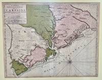
SANSON Nicolas
Carte Particuliere de la Caroline dresse sur les Memoires le plus Nouveaux. Par le Sieur S
Amsterdam: Pierre Mortier 1696. Engraved broadside map 19 x 23 5/8 inches plate mark dimensions with extensive pink and green wash. Some light browning but an attractive copy. Matted glazed and framed. One of two issues of this map this one being a bit larger based on the Thornton-Morden map of circa 1685. Pictures the colony from the Santee River to the South Edisto River and well inland up the Cooper River. Physical features and names of plantation and land owners are given in English "Nouveau Londre" on the Edistow sic River being exceptions; soundings are given at river mouths in Charleston Harbor and in the ocean along some beaches. Cumming Southeast in Early Maps 121. Kendall Early Maps of Carolina 17c: "This map has a wealth of names of owners of land in Carolina. Pierre Mortier unknown
Referenz des Buchhändlers : 48399
|
|
|
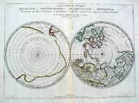
Sanson Nicolas. Antarctic & Arctic Map
Les Deux Poles Septentrional et Meridional ou Description des Terres Arcticques et Antarctiques; et des Pays circomvoisins jusques aux 45 Degres de Latitude
Paris 1657. Par N. Sanson d'Abbeville Geographe ordre du Roy. Spence 3017 lists a slightly different title but undoubtedly the same map. 53x38 cms. Period outline color central fold very good condition. A double hemisphere map to the North and South poles. The North pole is connected to Greenland and Spitzbergen but there is little other detailed coastline in the polar area. Europe Russia and Canada are delineated. The South pole is based on the great unknown Southland of Magellan. The tip of S. America is shown and a large land mass which encompasses the whole of the hemisphere but nothing else. unknown
Referenz des Buchhändlers : 5033
|
|
|
Sanson Nicolas
Les Isles Britanniques l'Espagne La France l'Italie Et l'Allemagne Histoire French Edition
paperback. Good. Access codes and supplements are not guaranteed with used items. May be an ex-library book. paperback
Referenz des Buchhändlers : 2016172509.G ISBN : 2016172509 9782016172506

|
|
|
SANSON Nicholas and Guillaume SANSON d. 1703
Amerique Septentrionale
Paris: Chez Pierre Mariette 1669. Copper-engraved map period hand colouring in outline. The most important French map of North America of its generation produced by the country's most esteemed family of cartographers.<br/> <br/>This very influential map was the official successor to Nicolas Sanson's 1650 map of North America. When Nicolas Sanson regarded as the father of the renaissance of cartography under Louis XIV died in July 1667 he left his flourishing business in the care of his eldest son Guillaume. The younger Sanson continued his father's partnership with the Mariette family who were prominent Parisian printers. Guillame was determined to publish a new updated edition of his father's Cartes Generales de toutes parties du Monde the first French general atlas originally published in 1657. The map of North America that appeared in the atlas although masterful was now considered to be geographically outdated. The present map which appeared in the second edition of the atlas featured updated toponymy and is geographically based on Nicolas Sanson's wall map of 1666 of which only two copies survive. While California is shown to be an island in line with popular perception unlike the map from 1650 it no longer attempts to build a geographical mythology in the place of the Pacific Northwest which was then totally unknown. Appropriately the magnificent baroque title cartouche which features swags and ribbons held aloft by putti has been placed to fill this enigmatic space. Cartographically the map appears to be based on Sanson's maps of "Le Canada ou Nouvelle France" and "Le Nouveau Mexique et La Floride." Lake Erie is shown in a recognizable form and the entire Great Lakes network is shown in greater detail than his father's map although the western lakes are still open-ended. On the East coast Long Island is shown and the shape of the Outer Banks is improved. Several Indian tribes are identified in New Mexico where the R. del Norte Rio Grande mistakenly flows from an interior lake and empties into the Mar Vermeio ou Mer Rouge Gulf of California. Iceland now appears in the Atlantic as well as a bit of Britain. The map proved to be highly successful and was sourced on numerous occasions by other mapmakers. The present copy is an example of Burden's first state of the map; a second state would be issued in 1690.<br/> <br/>Burden The Mapping of North America I 404; first state McCorkle New England in Early Printed Maps 669.4; McLaughlin California as an Island 45; Wagner Cartography of the Northwest Coast of America 399; Tooley "California as an Island" 8 in TooleyThe Mapping of America. Chez Pierre Mariette unknown books
Referenz des Buchhändlers : 25695

|
|
|
SANSON Nicholas and Guillaume SANSON d. 1703
Amerique Septentrionale
Paris: Chez Pierre Mariette 1690. Copper-engraved map period hand colouring in outline. Among the most important French maps of North America of the second half of the 17th century produced by the country's most esteemed family of cartographers.<br/> <br/>This very influential map was the official successor to Nicolas Sanson's 1650 map of North America. When Nicolas Sanson regarded as the father of the renaissance of cartography under Louis XIV died in July 1667 he left his flourishing business under the charge of his eldest son Guillaume. The younger Sanson continued his father's partnership with the Mariette family who were prominent Parisian printers. Guillame was determined to publish a new updated edition of his father's Cartes Generales de toutes parties du Monde the first French general atlas originally published in 1657. The map of North America that appeared in the atlas although masterful was now considered to be geographically outdated. The present map which appeared in the second edition of the atlas featured updated toponymy and is geographically based on Nicolas Sanson's wall map of 1666 of which only two copies survive. While California is shown to be an island in line with popular perception unlike the map from 1650 it no longer attempts to build a geographical mythology in the place of the Pacific Northwest which was then totally unknown. Appropriately the magnificent baroque title cartouche which features swags and ribbons held aloft by putti has been placed to fill this enigmatic space. Cartographically the map appears to be based on Sanson's maps of "Le Canada ou Nouvelle France" and "Le Nouveau Mexique et La Floride." Lake Erie is shown in a recognizable form and the entire Great Lakes network is shown in greater detail than his father's map although the western lakes are still open-ended. On the East coast Long Island is shown and the shape of the Outer Banks is improved. Several Indian tribes are identified in New Mexico where the R. del Norte Rio Grande mistakenly flows from an interior lake and empties into the Mar Vermeio ou Mer Rouge Gulf of California. Iceland now appears in the Atlantic as well as a bit of Britain. The map proved to be highly successful and was sourced on numerous occasions by other mapmakers. The present copy is an example of Burden's second state of the map with the date changed to 1690 in the cartouche and with additional place names and other changes: ".with minor alterations Terre de Jesso and Conibas inserted but without a coastline. Detroit d'Anian placed immediately above California and a few changes in spelling . New Albion is inserted in the north of the island and New York replaces New Amsterdam" Tooley.<br/> <br/>Burden The Mapping of North America 404 second state; McCorkle New England in Early Printed Maps 669.4; cf. McLaughlin California as an Island 45; cf. Wagner Cartography of the Northwest Coast of America 399; Tooley "California as an Island" 9 in TooleyThe Mapping of America. Chez Pierre Mariette unknown books
Referenz des Buchhändlers : 25648

|
|
|
Sanson Nicholas.
Le Royaume De France divise en Toutes fes Provinces…
<p>Copper engraved map double page 24" x 20" hand colored and large uncolored title cartouches. Some minor soiling a little wear along centerfold with old verso repair normal aging; very good. Samson 1600-1667 is often referred to as the father of French cartography. Louis XIII was impressed with his work and appointed him "Geographe Ordinaire du Roi". During his career Sanson would produce about 300 maps and his major atlas "Cartes Generales de Toutes les Parties du Monde" would represent an important part of his body of work. While two of his sons continued publication of his maps after his death Pieter Schenk 1655-1718 an important publisher and engraver in his own right published this map. The map is attractively colored and gives a detailed view of the provinces of France. The map is also decorated with a large title cartouche. Bagrow p. 185. map hist website.</p> books
Referenz des Buchhändlers : 104160

|
|
|
SANSON Nicolas
Antiquorum Africae Episcopatuum Geographica Descripto
Amsterdam: Mortier Pieter II 1723. unbound. very good. Map. Engraving with hand coloring. Image measures 14.5" x 19.25".<br/><br/> Includes parts of modern day Morocco Algeria Tunisia and Libya. Nicolas Sanson 1600-1667 is considered the founder of the French school of cartography. In reaction to the prevailing trend of Dutch lavishness Sanson favored minimal details focusing rather on accurate cartography than ornament. Large decorative title cartouche. Map is in good condition with ample margins. Staining along centerfold. Chipped near edges along centerfold.<br/><br/> Mortier, Pieter II unknown books
Referenz des Buchhändlers : 202384

|
|
|
SANSON Nicolas
Carte Particuliere de la Caroline dresse sur les Memoires le plus Nouveaux. Par le Sieur S
Amsterdam: Pierre Mortier 1696. Engraved broadside map 19 x 23 5/8 inches plate mark dimensions with extensive pink and green wash. Some light browning but an attractive copy. Matted glazed and framed. One of two issues of this map this one being a bit larger based on the Thornton-Morden map of circa 1685. Pictures the colony from the Santee River to the South Edisto River and well inland up the Cooper River. Physical features and names of plantation and land owners are given in English "Nouveau Londre" on the Edistow sic River being exceptions; soundings are given at river mouths in Charleston Harbor and in the ocean along some beaches. Cumming Southeast in Early Maps 121. Kendall Early Maps of Carolina 17c: "This map has a wealth of names of owners of land in Carolina." <br/><br/> Pierre Mortier unknown books
Referenz des Buchhändlers : 48399
|
|
|
SANSON Nicolas
Champagne et Brie etc.
Paris: Nicolas Sanson. unbound. Map. Uncolored copper engraving. Image measures 15 3/4" x 19 3/4". c.1660.<br/><br/> This elegant circa 1660 map by Nicolas Sanson features the famous French winemaking region of Champagne and the cheese making region of Brie. It extends south from the regions of Picardie to Burgundy and from Isle de France east to Lorraine. The map notes several towns and rivers with beautifully rendered mountains and forests throughout. An engraved grape surround cartouche features cherubs on the top left and the bottom right scale is surrounded by cherubs with mapping tools. The map has a stain in the upper right margin with minor foxing and minimal wear along the centerfold. Minor edge wear.<br><br>Nicolas Sanson 1600-1667 is considered the founder of the French school of cartography. This map is a fine example of his work and a pleasure to see black and white.<br/><br/> Nicolas Sanson unknown books
Referenz des Buchhändlers : 269694

|
|
|
SANSON Nicolas
Colchis Iberia Albania quaeg; Caucasiae Gentes Isthum qui Pontum Euxinum Caspiumq; Mare Interjacet Incolunt
Amsterdam: Mortier Pieter 1723. unbound. very good. Map. Engraving with hand outline. Image measures 14" x 18.75".<br/><br/> Beautifully detailed map showing the area between the the Black and Caspian Seas including modern day Russia Georgia Azerbaijan Armenia and Turkey. Full original margins have minor stains. Based on the plates by Nicolas Sanson 1600-1667 who is considered the founder of the French school of cartography. In reaction to the prevailing trend of Dutch lavishness Sanson favored minimal details focusing rather on accurate cartography than ornament.<br/><br/> Mortier, Pieter unknown books
Referenz des Buchhändlers : 209708

|
|
|
SANSON Nicolas
Galatia cujus Populi Tolistobogi Tectosages Trocmi mox Provincia sub Romanis in Primam et Secundam divisa et in ea Romana Itineraria
Amsterdam: Pierre Mortier. unbound. very good. Map. Engraving with hand outline. Image measures 13 11/16" x 22 3/8".<br/><br/> Rare map of northern Turkey centered around Ankara circa 1700. Minor scattered toning chipping to edges. Full original margins.<br/><br/> Pierre Mortier unknown books
Referenz des Buchhändlers : 215370

|
|
|
Sanson Nicolas
In Pharum Galliae antiquae Philippi Labbe Biturici & Societatis Iesu Sacerdotis disquisitiones geographicae : in quibus ad singula omnium locorum nomina aut furti sive plagii aut falsi sive erroris arguitur Philip. Labbe
Lutetiae Parisiorum: Sumptibus & Impensis Autoris 1647. Hardcover. Good. 16mo. Old leather; quite worn. pp 16 246 2. Liber primus only. <br/><br/> Sumptibus & Impensis Autoris hardcover books
Referenz des Buchhändlers : WB16371
|
|
|
SANSON Nicolas
Indiae extra Gangem Pars Septentrionalis. Indiae extra Gangem Pars Meridionalis
Paris 1680. unbound. Map. Uncolored copper plate engraving. Image measures 7.5" x 10". 1680.<br/><br/> This map of southeast Asia and the East Indies is essentially two maps on a single sheet. The map on the left depicts the northern portion of the India Ganges region representing Burma Myanmar Thailand Cambodia Vietnam and Laos while the map of the right depicts the southern portion and includes the Malay Peninsula Singapore Sumatra. The most interesting feature is the Lacus Chimay Chimay Lake the mythical lake located in northern Burma which was believed to be the source of the river system in Southeast Asia. Important towns and cities are identified with beautifully rendered topography depicted in profile. Map is in very good condition with some toning along original centerfold which shows repairs on verso. Minimal foxing. <br><br>Nicolas Sanson 1600-1667 is considered the founder of the French school of cartography. In reaction to the prevailing trend of Dutch lavishness Sanson favored minimal details focusing rather on accurate cartography than ornament. This map is a fine example of his work.<br/><br/> unknown books
Referenz des Buchhändlers : 264415

|
|
|
SANSON Nicolas
Isle et Royaume de Sicile
Paris 1663. unbound. very good. Map. Hand-colored engraving. 15" x 23".<br/><br/> This map of Sicily from the 17th century shows the entire island as well as the southwesternmost tip of the Italian peninsula. The names of the surrounding bodies of water are named in Latin and rivers mountains lakes and towns are noted on the map. Nicolas Sanson 1600-1667 is considered the founder of the French school of cartography. In reaction to the prevailing trend of Dutch lavishness Sanson favored minimal details focusing rather on accurate cartography than ornament. This map is a fine example of his work.<br/><br/> unknown books
Referenz des Buchhändlers : 283501

|
|
|
Sanson Nicolas
L'Afrique en Plusieurs Cartes Nouvelles et Exactes; & en Divers Tractes de Geographie et d'Histoire. . . .
Paris: Chez l'Autheur 1656. First Edition . Full Calf. Very Good. 4to. 23.5 by 17.5 cm. Unpaginated 100 pages of text plus 2 pp. of ads. With 18 copper engraved maps all two page plates each with hand-colored of boundaries. Maps include one of the entire continent then of its various regions as then known plus the islands off the continent. Also a map of Malta. Bound in contemporary calf. Condition: calf dry and rubbed on spine and joints and edges rubbed. Light to moderate soiling in the margins of the pages. Two bookplates -- one of the Marquis of Lothian the other the Newbattle Abbey Library. <br /><br /> Chez l'Autheur books
Referenz des Buchhändlers : 006682

|
|
|
Sanson Nicolas
L'Asie en Plusieurs Cartes Nouvelles et Exactes; & en Divers Tractes de Geographie et d'Histoire. . . .
Paris: Chez l'Autheur 1652. First Edition . Full Calf. Very Good. 4to. 23.5 by 17.5 cm. Unpaginated 102 pages of text plus 2 pp. of ads 1 Royal privilege page. With 17 copper engraved maps all two page plates each with hand-colored of boundaries. Maps include one of the entire continent then of its various regions as then known plus island groups. Separate maps for China and Japan. Bound in contemporary calf. Condition: Rebacked with joints making this obvious. Calf dry and rubbed on spine and joints and edges rubbed. Light to moderate soiling in the margins of the pages. Edge of a few leaves with short stretch slightly chewed-looking. Two bookplates -- one of the Marquis of Lothian the other the Newbattle Abbey Library. <br /><br /> Chez l'Autheur books
Referenz des Buchhändlers : 006683

|
|
|
Sanson Nicolas
L'Hydrographie Ou Description De L'Eau C'Est a Dire Des Mers Golfes Lacs Destroits Et Rivieres Principales Qui Font Dans La Surface Du Globe Terrestre
Paris: Sanson. Very Good. 1652. A very rare map from Nicolas Sanson. Imprint bears the date of 1652 although it is possible that this copy came from an atlas in the later 1600s. Light toning and edgewear with one corner slightly chipped. Light soil on lower margin. Hand-colored boundaries. Map borders measure 14" x 20 3/4". California is shown as an island and Terre Australe is a vague line encircling the Antarctic. Terre de Iesso is the name given to the land mass northwest of North America. Sanson 1600-1667 published many map versions of the world and is known as "the father of French cartography." ; 16 1/2" x 22 1/4" . Sanson unknown books
Referenz des Buchhändlers : 010748tw

|
|
|
SANSON Nicolas
L'Hydrographie ou Description de l'Eau; c'est a dire des Mers Golfes Lacs Destroits et Rivieres principales qui font dans la Surface du Globe Terrestre
Abbeville: Nicolas Sanson 1652. unbound. Map. Engraving with original outline hand coloring. Image measures 15 1/2" x 20 1/2". Shows light foxing and some mat burn.<br/><br/> A beautiful and unususual double hemisphere hydrological world map from the mid 17th century. Shows and highlights all bodies of water including oceans gulfs lakes straits and rivers. Wonderful light hachure marks hint of a land mass in Terre Australe. Nicolas Sanson 1600-1667 is considered the founder of the French school of cartography. In reaction to the prevailing trend of Dutch baroque design Sanson favored minimal details focusing rather on accurate cartography than ornament. Shirley R.W. World 394<br/><br/> Nicolas Sanson unknown books
Referenz des Buchhändlers : 287521

|
|
|
SANSON Nicolas
Le Gouvernement General du Dauphine et des pays circonvoisins ou sont la Savoye la Bresse
Paris 1652. unbound. Map. Engraving with hand outline color. Image measures 14 x 16.5%u201D.<br/><br/> This map of southeastern France includes the erstwhile provinces of Dauphiné corresponding roughly to the present departments of Isère Drôme and Hautes-Alpes as well as parts of Savoye and Bresse. At the time of the map%u2019s publication in 1652 Dauphiné was under the absolutist rule of King Louis XIV. The cartographer Nicolas Sanson as Royal Geographer to Louis XIV as well as Louis III likely understood the importance of this region to French interests of the time. The map thusly provides ample detail about the area including cities rivers mountains and significant forts. Hand-colored outlines indicate political boundaries. An elegant cartouche in the upper right corner of the map displays the title amidst scrollwork topped with the crown of the French monarchy. The map is in very good condition with full margins and no chips or tears. Nicolas Sanson 1600-1667 is considered the founder of the French school of cartography. In reaction to the prevailing trend of Dutch lavishness Sanson favored minimal details focusing rather on accurate cartography than ornament. This map points to his significant role within the French monarchy.<br/><br/> unknown books
Referenz des Buchhändlers : 251161

|
|
|
SANSON Nicolas
Les Suisses les Allies des Suisses et leurs Suiets; qui peuvent passer Sous le mon de Suisses. Partie de Souabe &c
Paris 1648. unbound. Map. Engraving with hand outline color. Image measures 14.5 x 21.5 inches.<br/><br/> This map of Switzerland centers on Lucerne covering approximately the area from Lake Constance south to Lake Como in Italy. Published in 1648 the map dates to the period of the Old Swiss Confederacy. Furthermore it predates by only a few years the Swiss Peasant War of 1653 a siege of Lucerne and Bern that demonstrated the significance of the rural population to the confederacy%u2019s stability. Hand-colored outlines on the map indicate the various independent states that made up the confederacy. A title cartouche with elaborate scrollwork adorns the lower right corner of the map. The map is in good condition with full margins and no chips or tears. Wear to lower margin. Nicolas Sanson 1600-1667 is considered the founder of the French school of cartography. In reaction to the prevailing trend of Dutch lavishness Sanson favored minimal details focusing rather on accurate cartography than ornament. This map demonstrates the skill that made him such a valuable asset to the French monarchy.<br/><br/> unknown books
Referenz des Buchhändlers : 251162

|
|
|
SANSON Nicolas
Paphlagonia Heroicis Temporibus Henetorum Populorum sede Clara; cujus Paphlagonia Maritima suit Romanorum Aetate Ponti Regni Pars Occidentalior In qua Sinope.
Amsterdam: Mortier Pieter. unbound. very good. Map. Engraving with original hand outline. Image measures 14.5" x 18.75".<br/><br/> Beautiful and rare map of northern Anatolia in Turkey circa 1708. Detailed and animated cartouche. Paphlagonia is the ancient area along the southern coast of the Black Sea. Full original margins light scattered foxing. Based on earlier plates by Nicolas Sanson 1600-1667 who is considered the founder of the French school of cartography. In reaction to the prevailing trend of Dutch lavishness Sanson favored minimal details focusing rather on accurate cartography than ornament.<br/><br/> Mortier, Pieter unknown books
Referenz des Buchhändlers : 215454

|
|
|
SANSON Nicolas
Partie de Barbarie ou Sontles Royaumes de Tunis et Tripoli
Paris 1683. unbound. Map. Copper engraving with hand coloring. Image measures 7 5/8 x 11 1/4 inches.<br/><br/> This map published in Paris in Afrique en plusieurs cartes is one of Sanson's small atlas maps of depicting various African regions. This map offers extensive detail on the cities of North Africa as well as topographical and geographical features with mountains beautifully rendered in profile. Nicolas Sanson 1600-1667 is considered the founder of the French school of cartography. In reaction to the prevailing trend of Dutch lavishness Sanson favored minimal details focusing rather on accurate cartography than ornament. This map is a fine example of his work.<br/><br/> unknown books
Referenz des Buchhändlers : 297468

|
|
|
Sanson Ronald
O PODER DO AMOR: A SOLU��O PARA TUDO EST� EM VOC� Portuguese Edition
NEW. unknown
Referenz des Buchhändlers : BIB-NOV-15-2025-133707 ISBN : 9798792761499 9798792761

|
|
|
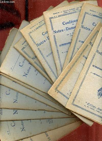
Sanson & Baudrillart & Ponsart
Conférences de Notre-Dame de Paris - Lot de 14 fascicules - Voir notice.
Spes. 1927-1828. In-12. Broché. Etat d'usage, Couv. légèrement passée, Agraffes rouillées, Papier jauni. 24 + 24 + 23 + 24 + 23 + 24 + 51 + 24 + 24 + 24 + 24 + 24 + 24 + 82 pages agrafées - rousseurs sur les plats... . . . Classification Dewey : 200-RELIGION
Referenz des Buchhändlers : R320133137
|
|
|
Sanson & Mortier
Le Gouvernement Général de Languedoc. Partie Occidentale. antique map of Languedoc
Amsterdam: Pierre Mortier 1742. A BEAUTIFUL HAND-COLORED MAP OF WESTERN LANGUEDOC and areas to the west and north. 60 x 45.5 cm plate 62 x 52 cm sheet. The areas described in the title are FULLY COLORED BY A CONTEMPORARY HAND. Printed on fine thick laid paper. Reverse blank. A fine impression. A PRISTINE EXAMPLE with the paper FINE AND BRIGHT. Very scarce in such fine condition. <br/><br/> Pierre Mortier unknown
Referenz des Buchhändlers : 38209
|
|
|
Sanson ( Lucien )
Géographie du département de la Drôme
Librairie Rambaud, Romans sd ( 1946 ), in-8 cartonnage éditeur illustré, dos toilé, 104pp avec des photographies in-texte et une grande carte dépliante en couleurs - très bon état
Referenz des Buchhändlers : 62660
|
|
|
Sanson ( R.P. )
La conscience française et son drame
Desclée de Brouwer 1941, in-12 broché, 54pp - très bon état
Referenz des Buchhändlers : 72445
|
|
|
SANSON (A.)
L'hérédité normale et pathologique -- EDITION ORIGINALE -- BON EXEMPLAIRE
P., Asselin et Houzeau, 1893; un volume in 8 relié en demi-soie verte, dos orné d'un fleuron doré, couvertures conservées (reliure de l'époque), (qq. rousseurs), 7pp., 431pp.
Referenz des Buchhändlers : 4654
|
|
|
SANSON (Andre).
Les moutons. Histoire naturelle et zootechnie. Quatrième édition. Ouvrage orné de 56 gravures.
Paris Librairie agricole de la maison rustique 1885. VI. 168 pages. 48 pages. 12x185cm. Broché. Non rogné. Couverture imprimée. Couverture cassée. Manques. Mouillures. Salissures. Manques et déchirures au dos. Pages de texte en bon état. Paris, Librairie agricole de la maison rustique, 1885. unknown
Referenz des Buchhändlers : 101808

|
|
|
SANSON (André)
La maréchalerie ou ferrure des animaux domestiques.
1897 Paris, Librairie agricole de la maison rustique, 1897, in 8 br. de VI-163-4 pp. de catalogue, couverture illustrée, bon ex.
Referenz des Buchhändlers : 7134
|
|
|
SANSON (André).
Applications de la zootechnie : boeuf, mouton, chèvre, porc. Economie du bétail.
Paris Librairie Agricole de la Maison Rustique 1867 1 vol. relié fort vol. in-12, demi-basane fauve à coins, dos à nerfs orné de fleurons dorés et d'encadrements à froid, 572 pp., 89 jolies gravures in-texte et à pleine page. Petites traces de frottement sans gravité au dos et aux coins. Sinon très bon exemplaire, dans une agréable reliure d'époque.
Referenz des Buchhändlers : 79947
|
|
|
SANSON (André).
La Maréchalerie ou Ferrure des animaux domestiques.Troisième édition.
Paris, Librairie agricole de la Maison Rustique,1897 ;in-8°,broché,couverture beige imprimée et illustrée en noir; VIpp.,163pp.,4pp.(catalogue); petite tache d'encre noir à la couverture en pied au 1er plat et dos et au 2ème plat,avec petites traces dans la marge supérieure et inférieure des 4 derniers feuillets, mais exemplaire fort correct.
Referenz des Buchhändlers : c2706
|
|
|
SANSON (André).
La maréchalerie ou ferrure des animaux domestiques.
Paris, Librairie agricole de la Maison rustique, 1868 ; in-16 (12 x 19 cm), broché. 180 pp. - 36 pp. (catalogue de la librairie agricole). 28 gravures in-texte. Couverture imprimée présentant des salissures.
Referenz des Buchhändlers : 13305

|
|
|
SANSON (André).-
Traité de Zootechnie. Tome III [seul] : Zoologie et zootechnie spéciales. Equidés caballins et asiniens. Troisième édition, revue et corrigée (3e tirage).
P., Librairie Agricole de la Maison Rustique (Bibliothèque Agricole), 1896, in 12 broché, VII-382 pages ; 20 figures ; index in-fine ; quelques rousseurs ; couverture fanée.
Referenz des Buchhändlers : 62034
|
|
|
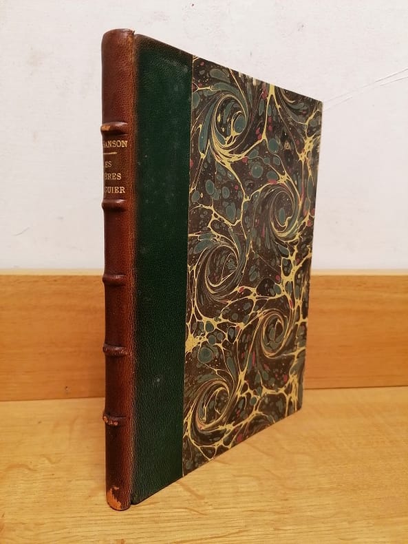
SANSON (Armand).
Deux sculpteurs normands : Les frères Anguier.
Rouen E. Cagniard 1889 1 vol. relié in-8, demi-chagrin vert, dos à nerfs, 110 pp., frontispice et 12 illustrations in et hors-texte. Dos passé, sinon très bon exemplaire.
Referenz des Buchhändlers : 115711
|
|
|
SANSON (Armand).
Deux sculpteurs normands : Les frères Anguier.
Rouen E. Cagniard 1889 1 vol. relié in-8, demi-chagrin vert, dos à nerfs, 110 pp., frontispice et 12 illustrations in et hors-texte. Dos passé, sinon très bon exemplaire.
Referenz des Buchhändlers : 115711
|
|
|
SANSON (Charles-Henri).
La Révolution française vue par son bourreau : journal de Charles-Henri Sanson édité et préfacé par Monique Lebailly.
Paris L'Instant, coll. "Griffures" 1988 1 vol. broché in-8, broché, 339 pp. Très bon état.
Referenz des Buchhändlers : 117821
|
|
|
SANSON (Charles-Henri).
La Révolution française vue par son bourreau : journal de Charles-Henri Sanson édité et préfacé par Monique Lebailly.
Paris L'Instant, coll. "Griffures" 1988 1 vol. broché in-8, broché, 339 pp. Très bon état.
Referenz des Buchhändlers : 117821
|
|
|
Sanson (d'Abbeville, Nicolas):
Ambrones in Helvetiis. Basse partie du Pays d'Argow en Suisse. Parts de l' Eveché de Constance. Partie Septentrion 1e du Canton de Berne.
A Paris chez P. Mariette 1660. Blattgrösse: 44x58 cm. Grenzkolorierte Karte (36,7x55 cm) von Nicolas Sanson, gestochen von Somer.
Referenz des Buchhändlers : 33638AB
|
|
|
SANSON (d’ABBEVILLE N.) Georgraphe ordinaire de Sa Majesté:
Mappe-Monde ou Carte générale du Globe Terrestre. Représentée en deux Plan-Hémisphéres, Reveue et changée en plusieurs endroits. Suivant les Relations les plus récentes. Par le Sr. SANSON.
(1734), 20.5x30.5 cm (la carte) carte coloriée et montée sur carton, légèrement bruni, 1 planche. (23x33.4 cm, la feuille).
Referenz des Buchhändlers : 129971aaf
|
|
|
SANSON (Guillaume)
Introduction a la géographie. Première partie où sont 1. indiquées les sciences dont la geographie emprunte plusieurs principes. 2. La description des differentes manieres dont cette science est representée. 3. L'explication des termes de toutes les parties de la géographie. 4. Une instruction de l'usage des cartes . Par le Sr. Sanson d'Abbeville geographe ordinaire du roy. Seconde édition augmentée. - Catalogue des Livres et Traitez de Geographie des sieurs Nicolas SANSON, geographe du Roy…
1690 basane brune, dos à n. 2 tomes en un vol. in-12, (12ff.), 144pp. et titre, 178pp., (7ff.), 48pp., (catalogue des libraires), 4 planches dépliantes (la quatrième est incomplete de sa plus grande partie…) A Paris chez l'auteur, aux galleries du Louvres, vis-à-vis l'Eglise de St. Nicolas. 1690
Referenz des Buchhändlers : 16779
|
|
|
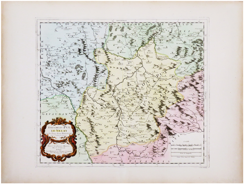
SANSON (Guillaume) & SANSON d'ABBEVILLE (Nicolas).
[LE PUY-en-VELAY] Évesché du Puy Le Velay l'un des vingt deux diocèses du Languedoc.
Paris, P. Mariette, 1670. 367 x 423 mm.
Referenz des Buchhändlers : LBW-7226
|
|
|
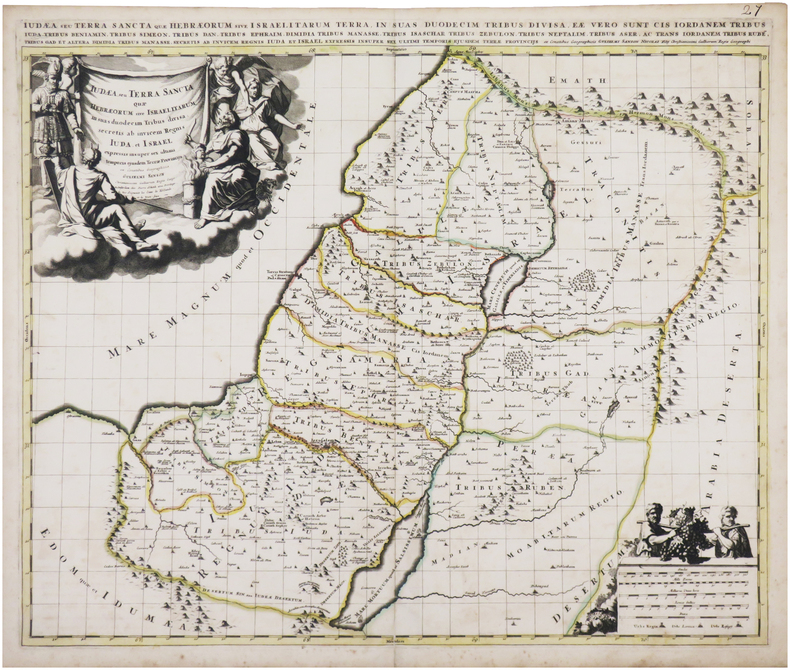
SANSON (Guillaume).
Judæa seu Terra Sancta quæ Hebræorum sive Israelitarum in suas duodecim tribus divisa.
Amsterdam, Pierre Schenk, [circa 1700]. 487 x 577 mm.
Referenz des Buchhändlers : LBW-8050
|
|
|
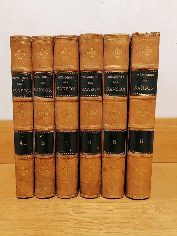
SANSON (H.);
Sept Générations d'exécuteurs. MÉMOIRES des SANSON, mis en ordre, rédigés et publiés par H. Sanson.
Dupray de la Mahérie et Cie Paris 1862-63 6 vol. 6 vol. in-8 de 432 pp. 2 ff.n.ch., 2 ff.n.ch. 447 pp. 2 ff.n.ch., 2 ff.n.ch. 481 pp. 1 f.n.ch., 2 ff.n.ch. 451 pp. 2 ff.n.ch., 2 ff.n.ch. 516 pp. 1 f.n.ch. et 2 ff.n.ch. 544 pp. 1 f.n.ch.; demi-chagrin rouge de l'époque, dos à nerfs orné.
Referenz des Buchhändlers : 11174

|
|
|
SANSON (Henri).
Sept générations d'exécuteurs, 1688-1847: mémoires des Sanson mis en ordre, rédigés et publiés par H. Sanson.
Paris Dupray de La Mahérie 1862-1863 6 vol. relié 6 vol. in-8, demi-basane fauve, dos à nerfs ornés de frises et fleurons dorés, pièces de titre et de tomaison de basane noire (reliure de l'époque), 432, 447 + (5), 481 + (3), 451 + (5), 516 + (4) et 544 + (2) pp. Dos frottés, rousseurs éparses, sinon en bon état général.
Referenz des Buchhändlers : 116641
|
|
|
SANSON (J.).
La prévision du temps en agriculture. Avec 60 figures intercallées dans le texte. Encyclopédie agricole publiée par une réunion d'Ingénieurs agronomes sous la direction de G. Wery.
Paris Baillière et fils 1925. 320 pages. 185x12cm. Broché. Non coupé. Couverture imprimée éditeur. Accidents aux coiffes. Légères taches sur les plats. Intérieur bruni. Très bon état. Paris, Baillière et fils, 1925. unknown
Referenz des Buchhändlers : 105549

|
|
|
SANSON (J.)
Mémorial de la Météorologie Nationale. Recueil de données statistiques relatives à la climatologie de la France
Couverture rigide. Bon/1953. in-folio. Paris 1953 in-folio pet. XI 1bl 148pp 1 carte toile bleutée. Rel. de l'ép. Grande carte dépliante h.t. en couleur logée à l'intérieur du second plat représentant les précipitations annuelles de 1891 à 1930. Cachets gras d'une ancienne bibliothèque unknown
Referenz des Buchhändlers : 8874
|
|
 Per e-mail erhalten
 Als pdf-Dokument herunterladen
 RSS feed


