|
Army Language School (U S )
Spoken Syrian.
Paperback / softback. New. paperback
Referenz des Buchhändlers : A9781014592798 ISBN : 1014592798 9781014592798

|
|
|
Army Language School U S
Spoken Syrian.
Paperback / softback. New. paperback
Referenz des Buchhändlers : B9781014592798 ISBN : 1014592798 9781014592798
|
|
|
Army Language School U S
Supplimentary sic to Spoken Iraqui Arabic
Paperback / softback. New. paperback
Referenz des Buchhändlers : A9781014569417 ISBN : 1014569419 9781014569417

|
|
|
Army Language School U S
Supplimentary sic to Spoken Iraqui Arabic
Paperback / softback. New. paperback
Referenz des Buchhändlers : B9781014569417 ISBN : 1014569419 9781014569417
|
|
|
Army Language School (U S )
The History of Korea
Paperback / softback. New. paperback
Referenz des Buchhändlers : A9781014008657 ISBN : 1014008654 9781014008657

|
|
|
Army Language School (U S )
The History of Korea
Paperback / softback. New. paperback
Referenz des Buchhändlers : B9781014008657 ISBN : 1014008654 9781014008657
|
|
|
Army Language School (U S )
Timely Propaganda.
Paperback / softback. New. paperback
Referenz des Buchhändlers : A9781014689726 ISBN : 1014689724 9781014689726
|
|
|
Army Language School U S
Timely Propaganda.
Paperback / softback. New. paperback
Referenz des Buchhändlers : B9781014689726 ISBN : 1014689724 9781014689726
|
|
|
Army Laughs Magazine
1955: June July Issue Volume 3 Number 1 of Army Laughs Magazine
Worn but Complete. unknown
Referenz des Buchhändlers : 76511
|
|
|
Army Law Training & Publications
The rights of a soldier charged with an offence under the army act 1955
Army Defece Council 1987 Scarce booklet 15 page booklet Army Defece Council paperback
Referenz des Buchhändlers : 037078
|
|
|
Army League
British defence policy in South-East Asia
London : Army League 1966. First Edition. Paperback. Fine copy in the original stiff-card wrappers. Particularly and surprisingly well-preserved; tight bright clean and especially sharp-cornered.; 8vo 8"" - 9"" tall; 67 pages; Description: 67 p. ; 22 cm. Subjects: Great Britain -- Foreign relations. London : Army League paperback
Referenz des Buchhändlers : 194514

|
|
|
Army Lieutenant Shigetsu Harada
first battle <Japanese Version>
Jitsugyo no Nihonsha N.A. Soft Cover. Fine. The book is in fine condition. Jitsugyo no Nihonsha paperback
Referenz des Buchhändlers : 2111902154604054
|
|
|
Army Lieutenant Colonel Takekazu Ashhara, Recent Trends in Aviation Equipment and Warfare, p15, , p. 15
Nagoya Regiment District General School Bulletin No. 166 January 1944 <Japanese Version>
Nagoya Regiment District General School 1944. Soft Cover. Fine. Volume: 1 Nagoya Regiment District General School paperback
Referenz des Buchhändlers : 2110502150412305
|
|
|
Army Lieutenant Commander Yurin Omura
Wakanyo Commander-in-Chief's Interview Kaiko Series 4 <Japanese Version>
Kaikosha 1939. Soft Cover. Fine. Volume: 1 Kaikosha paperback
Referenz des Buchhändlers : 2110502150408660
|
|
|
Army Lineage Series(Office-Chief Milit. Hist)
ARMOR-CAVALRY- PART 1: REGULAR ARMY AND ARMY RESERVE
Government Printing Office. Used - Very Good. Very Good condition. Part 1. Reprinted 1984. United States Army Cavalry A copy that may have a few cosmetic defects. May also contain a few markings such as an owner’s name short gifter’s inscription or light stamp. Government Printing Office unknown
Referenz des Buchhändlers : S11A-02557
|
|
|
Army Lineage Series: Armor-Cavalry (Part 1) Regular Army and Army Reserve Reserve
Army Lineage Series: Armor-Cavalry Part 1 Regular Army and Army
Very Good. VG 2 volume set. Part 1 & 2. unknown
Referenz des Buchhändlers : E9-VEW1-FXIP
|
|
|
Army List
The Army List Spring 1969. Part II. Officers in receipt of Retired Pay.
London: Her Majestys Stationery Office 1969. Paperback . Very Good. Covers with some wear chipping and creasing some corner creasing otherwise about very good. Her Majestys Stationery Office, paperback
Referenz des Buchhändlers : C154266
|
|
|
Army List
The Army List Spring 1968. Part 1.
London: Her Majestys Stationery Office 1968. Paperback . Very Good. Light wear creasing and spine fading otherwise very good. Ink name to top edge of text block. Her Majestys Stationery Office, paperback
Referenz des Buchhändlers : C154262
|
|
|
Army List
The Army List for July 1872
War Office 1872. Book. Very Good. Hardcover. 8vo - over 7¾" - 9¾" tall. Full burgundy buckram boards with gilt lettering to spine. NO CHIPPING & NO SPLITTING to CLEAN boards. A few small round watermarks to boards - not affecting text. Internally CLEAN with NO INSCRIPTIONS. Text starts at page i - hence lacking titlepage. Some mild chipping to corners of first leaf. War Office Hardcover
Referenz des Buchhändlers : 14606
|
|
|
Army List
The Army List for July 1881
War Office 1881. Book. Very Good. Hardcover. 8vo - over 7¾" - 9¾" tall. Full burgundy buckram boards with gilt lettering to spine. NO CHIPPING & NO SPLITTING to CLEAN boards. NO MARKS to boards. Internally CLEAN with NO INSCRIPTIONS. Some tanning to first leaf. Tiny nicks to corners of first leaf. TIGHT textblock. NO LOOSE & NO MISSING leaves. War Office Hardcover
Referenz des Buchhändlers : 14605
|
|
|
Army List
The Army List for October 1860
Her Majesty's Stationary Office HMSO 1860. Book. Fair. Soft cover. 8vo - over 7¾" - 9¾" tall. There are no covers and hence starts on titlepage. The spine has broken down and the gatherings are either loose or working loose. Small chip to top right corner of titlepage. A fair reading working copy of a SCARCE & early army list. Her Majesty's Stationary Office (HMSO) Paperback
Referenz des Buchhändlers : 14638
|
|
|
Army List
The Monthly Army List - June 1881
War Office 1881. Book. Very Good. Hardcover. 8vo - over 7¾" - 9¾" tall. NO CHIPPING & NO SPLITTING to CLEAN boards. Light wear only to red buckram boards with gilt title on spine. NO MARKS to boards & NO FADING to red spine. Internally the text starts on page vii meaning the alphebetical index starts at Atkinson - no pages missing at rear of text. War Office Hardcover
Referenz des Buchhändlers : 027191
|
|
|
Army list
The Quarterly Indian Army List : January 1919 4 vols
United Kingdom: Naval & Military Press 2008. Book. Fine. Soft cover. paperback four volumes complete pictorial card covers a fine tightly bound set with a clean and unmarked text. A reprint of the original Government of India publication of 1919. A heavy set which may attract a request for additional postage if ordered from certain locations outside the United Kingdom. . Naval & Military Press Paperback
Referenz des Buchhändlers : 284767
|
|
|
Army List
The Quarterly Army List - Jan - Mar 1892
War Office 1892. Book. Very Good. Hardcover. 8vo - over 7¾" - 9¾" tall. Original half red calf leather binding with marbled boards. Wear to extremities with slither chipping to head of spine & cracking to hinge joints front and back - boards still held by webbing gutter hinges. Scuffing and dusting to boards. Internally complete with NO MISSING leaves. War Office Hardcover
Referenz des Buchhändlers : 14353
|
|
|
ARMY LIST.
A List of All the Officers of the Army: Viz. The General and Field Officers; The Officers of the Several Troops Regiments Independent Companies and Garrisons: With an Alphabetical Index to the Whole. Also a List of the Officers of The Royal Regiment of Artillery The Corps of Engineers The Irish Artillery and Engineers And of the Marine Forces: The Officers on Half-Pay; and a Succession of Colonels. To which are Likewise Added the Officers of the Militia Forces and of the Fencible and Provincial Regiments in Great-Britain.
J. Millan. London. War Office 20 July 1781. pp. iv 347 i blank iv Alterations whilst Printing 79 i blank ii Books Printed for and Sold by J. Millan. Contemporary calf gilt rebacked with old spine relaid some scuffing and light wear to the boards occasional foxing a few top corners lightly creased interleaved with unused blanks up to page 301 the odd marginal note a nice copy. Issued nearly three months before the Siege of Yorktown the last major battle in the American War of Independence. Listed in the section of Lieutenant-Generals is Charles Earl Cornwallis the English commander at Yorktown and amongst the Physicians for the Hospitals in North America is mentioned John Hunter 'the other John Hunter' MD FRS 1754-1809. [J. Millan. London.]. War Office, 20 July, 1781. hardcover
Referenz des Buchhändlers : 59030
|
|
|
ARMY LIST.
A List of the Officers of the Army
London: War-Office 28 April 1783. First edition compiled just a few months before the conclusion of the War of Independence. These eighteenth-century Army Lists are becoming increasingly elusive those with relevance to the American Wars being particularly desirable and especially so when as here they are printed on thick paper and presented in the style of binding which seems to have been reserved by the War Office for presentation copies. A very handsome piece indeed. Octavo 228 x 138 mm. Contemporary red morocco green morocco label flat spine elaborately gilt with gilt pentaglyph and metope stylised quatrefoil and plain reeded rolls gilt panel of swags and sunflowers to the boards gilt edge-roll all edges gilt palm branch and quatrefoil roll gilt to the turn-ins marbled endpapers Greek key roll to boards floral roll to turn-ins and all edges gilt. Lightly rubbed spine a touch sunned small chip from the lower edge of the label no loss of lettering corners just a little bumped but a very good copy. hardcover
Referenz des Buchhändlers : 124569
|
|
|
ARMY LIST.
List of the General and Field-Officers, as they Rank in the Army; of the officers in the several regiments of Horse, Dragoons, and Foot, on the British and Irish establishments, with the dates of their commissions, as they rank in each corps, and as they rank in the army : the Royal Regiment of Artillery, Irish Artillery, Engineers, the Marines, and independent companies : governors, lieutenant-governors, of His Majesty's garrisons at home and abroad, with their allowances, and the officers on half-pay &c. : to which is now added the succession of colonels.
8vo (210 x 130mm), 18, 13-48, 52-91, 93-140, 133-148, 12, [2]pp., interleaved throughout with blank pages, ex-ministry of Defence Library, cont. calf, rubbed and worn, leather peeled away from boards, joints cracked. Annual Army list to November, 1763. The pagination of this book is erratic to say the least: there are no pages 49, 50 or 51, page 52 follows p. 48, from thence onwards to p. 91 (38th Foot) inclusive, all the odd numbers are on the verso side, there is no page 91, page 93 (39th Foot) follows p. 91, and from thence to p. 140 the pagination is normal, a page numbered 133 (70 Companies of Marines) follows p. 140, and this continues to p. 148, thence follows 12 pages (succession of Colonels) and a final leaf (Additions since Printing). It seems the printer who set up this list, must have been a 'Dreamer'. ESTC (N62475) locates a single copy of this edition at the National Archives.
|
|
|
ARMY LIST.
List of the General and Field-Officers, as they Rank in the Army; of the officers in the several regiments of Horse, Dragoons, and Foot, on the British and Irish establishments, with the dates of their commissions, as they rank in each corps, and as they rank in the army : the Royal Regiment of Artillery, Irish Artillery, Engineers, the Marines, and independent companies : governors, lieutenant-governors, of His Majesty's garrisons at home and abroad, with their allowances, and the officers on half-pay &c. : to which is now added the succession of colonels.
4to, (275 x 195mm), 18, 13-48, 52-91, 93-140, 133-148, 12, [2]pp., LARGE PAPER COPY, in addition there are two final leaves with manuscript additions for the 32 Regiment of Foot and the 36 Regiment of Foot, later half calf, rubbed, lacks spine, covers detached. Annual Army list to November, 1763. The pagination of this book is erratic to say the least: there are no pages 49, 50 or 51, page 52 follows p. 48, from thence onwards to p. 91 (38th Foot) inclusive, all the odd numbers are on the verso side, there is no page 91, page 93 (39th Foot) follows p. 91, and from thence to p. 140 the pagination is normal, a page numbered 133 (70 Companies of Marines) follows p. 140, and this continues to p. 148, thence follows 12 pages (succession of Colonels) and a final leaf (Additions since Printing). It seems the printer who set up this list, must have been a 'Dreamer'. Provenance: ex-ministry of Defence Library. ESTC (N62475) locates a single copy of this edition at the National Archives.
|
|
|
ARMY LOGISTICS MANAGEMENT COLL FORT LEE VA
Army Logistician. Volume 33 Issue 5 September-October 2001
PN. New. 2001. Soft Cover. Date is original print. This is a reprint edition . PN paperback
Referenz des Buchhändlers : 1337796
|
|
|
ARMY LOGISTICS MANAGEMENT COLL FORT LEE VA
Army Logistician. Volume 38 Issue 6 November-December 2006
PN. New. 2006. Soft Cover. This is a reprint edition. . PN paperback
Referenz des Buchhändlers : 1346020
|
|
|
ARMY LOGISTICS MANAGEMENT COLL FORT LEE VA
Army Logistician. Volume 38 Issue 3 May-June 2006
PN. New. 2006. Soft Cover. PN paperback
Referenz des Buchhändlers : 1345355
|
|
|
ARMY LOGISTICS MANAGEMENT COLL FORT LEE VA
Army Logistician. Volume 38 Issue 5 September-October 2006
PN. New. 2006. Soft Cover. This is a reprint edition. . PN paperback
Referenz des Buchhändlers : 1345829
|
|
|
ARMY LOGISTICS MANAGEMENT COLL FORT LEE VA
Army Logistician. Volume 39 Issue 2 March-April 2007
PN. New. 2007. Soft Cover. This is a reprint edition. . PN paperback
Referenz des Buchhändlers : 1346552
|
|
|
ARMY LOGISTICS MANAGEMENT CENTER FORT LEE VA LOGISTICS RESEARCH AND DOCTRINEDEPT
CAN OPERATIONS RESEARCH CONTRIBUTE TO LOGISTICS RESEARCH
PN. New. 1961. Soft Cover. Date is original print. This is a reprint edition. . PN paperback
Referenz des Buchhändlers : 714321
|
|
|
Army Madras Presidency
A List of the Officers of the Army Ordnance and Medical Departments Serving Under the Presidency of Fort St. George
Rarebooksclub.com. Used - Like New. Used - Like New. This is a reproduction of an out of print title. This book may have occasional imperfections such as missing or blurred pages poor pictures errant marks etc. that were either part of the original artifact or were introduced by the scanning process. Ships from UK in 48 hours or less usually same day. Your purchase helps support Sri Lankan Children's Charity 'The Rainbow Centre'. 100% money back guarantee. We are a world class secondhand bookstore based in Hertfordshire United Kingdom and specialize in high quality textbooks across an enormous variety of subjects. We aim to provide a vast range of textbooks rare and collectible books at a great price. Our donations to The Rainbow Centre have helped provide an education and a safe haven to hundreds of children who live in appalling conditions. We provide a 100% money back guarantee and are dedicated to providing our customers with the highest standards of service in the bookselling industry. Rarebooksclub.com unknown
Referenz des Buchhändlers : Z1-C-089-01125 ISBN : 1236092570 9781236092571

|
|
|
ARMY MANAGEMENT STAFF COLLEGE FORT BELVOIR VA
Logistics Power Projection Platform
PN. New. 1997. Soft Cover. Date is original print. This is a reprint edition . PN paperback
Referenz des Buchhändlers : 296235
|
|
|
ARMY MANEUVER SUPPORT CENTER FORT LEONARD WOOD MO
Range of Future Threats
PN. New. 2012. Soft Cover. Date is original print. This is a reprint edition. . PN paperback
Referenz des Buchhändlers : 1355155
|
|
|
ARMY MANEUVER SUPPORT CENTER FORT LEONARD WOOD MO
The US Army Learning Concept for 2015
PN. New. 2012. Soft Cover. Date is original print. This is a reprint edition. . PN paperback
Referenz des Buchhändlers : 1355101
|
|
|
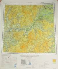
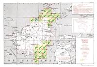
Army Map Service
10 maps of Central Asia from AMS map series 1301
Washington DC: Army Map Service 1963. 10 color broadside maps showing various regions of regions ranging from Xinjiang up to Mongolia Northeast USSR and the Yellow Sea; sizes ranging between 24.5 x 21.5 in. to 26 x 32 in. 1:1000000 scale; showing roadways settlements and elevation one map with smudged printing else all largely fine. This group includes the following maps first edition unless otherwise stated: Wen-Ch'eng NM 51 2nd ed; Nan-T'ung NI 51 6th ed.; O-Chi-Na Ho NK 47; Ha-Erh-Pin HarbinNL 52 2nd ed.; Ch'eng-Hua NL 45; Zeya NN 52 3rd ed.; Ha-Mi Kumil NK46; Hobsogol NM 47; Jirgalanta Kobdo NM 46; Ch'ieh-Mo Charchan Bazar NJ 45. A scattered sampling of maps from the International Map of the World. The IMW was the cartographical brain child of Albrecht Penck who in the late 19th century conceived of a series of maps uniformly produced that would cover the whole of the Earth's land mass. To accomplish this the planet was divided into 2500 segments and each segment was to be produced independently by various governments and NGOs. The project was envisioned to be strictly apolitical but this meant that buy-in was slow for governmental bodies and the lack of thematic information frustrated potential contributors in industry and led to University of Wisconsin cartographer Arthur Robinson declaring the resulting maps "cartographic wallpaper." When government agencies did contribute they did so as here in service to a baldly political interest in a given region. Army Map Service unknown
Referenz des Buchhändlers : 70465
|
|
|
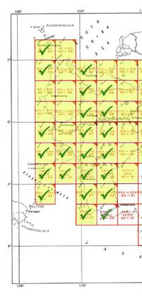
Army Map Service
23 maps of Borneo from Series AMS T532
Washington DC: Army Map Service 1945. 23 broadside color maps; each about 22.25 x 20 in. 1:250.000 scale covering two separate regions: North Borneo including part of Brunei and Southeast Borneo from Samarinda to Kualakapuas and inland to Boentok. All maps in fine condition. Maps included are: NB-49 X; NB-50 I J O P Q R S V W; NA-50-D; SA-50-C D G H I M N O S T U; SB-50-A. The Army Map Service was the primary map producing body of the US Military through WWII. Service cartographers many of them women recruited after Pearl Harbor produced 40000 maps covering 400000 miles between 1941 and 1945. LoC Their work formed the basis of silk escape maps provided to soldiers. Army Map Service unknown
Referenz des Buchhändlers : 70379
|
|
|
Army Map Service
23 maps of Borneo from Series AMS T531
Washington DC: Army Map Service 1944. First edition 23 color broadside maps each about 22 x 20 in.; 1:200000 scale covering the western section of the series from XI-XII 42-43 to XXVII-XXVIII 48-49 lacking XI-XII 44-45 XIII-XIV 44-45 XIII-XIV 50-51 XV-XVI 42-43 XV-XVI 44-45 XVII-XVIII 42-43 XVII-XVIII 44-45 and XIV-XX 44-45. Geographical region covered is the west coast From Kuching to Soekamara and some outlying islands. Each map is numbered in marker on the bottom left margin otherwise clean and near fine. The Army Map Service was the primary map producing body of the US Military through WWII. Service cartographers many of them women recruited after Pearl Harbor produced 40000 maps covering 400000 miles between 1941 and 1945. LoC Their work formed the basis of silk escape maps provided to soldiers. Army Map Service unknown
Referenz des Buchhändlers : 70378
|
|
|
Army Map Service
9 maps from AMS map series L582 Inner China
Washington D.C.: Army Map Service 1945. 9 broadside maps approx. 22½" x 20" 1:250000 scale; showing roadways trainlines borders settlements and elevation a few maps soiled but otherwise largely fine. Includes the following maps: Li-Hsien H-49-P; Chao-T'ung G-48-B; Kuei-Ting Kan-Ch'i G-48-L; En-Shih H-49-H; Lang-Chung H-48-D; Pa-Chung H-48-E; Wu-Shih-Chiang F-49-T; Lai-Feng H-49-N; Peng-Shui H-49-M. Covering portions of the border area between China and Vietnam and sections of Szechuan Province. The Army Map Service was the primary map producing body of the US Military through WWII. Service cartographers many of them women recruited after Pearl Harbor produced 40000 maps covering 400000 miles between 1941 and 1945. Their work formed the basis of the many silk escape maps provided to soldiers. Army Map Service unknown
Referenz des Buchhändlers : 70449
|
|
|
ARMY MAP SERVICE. [USA.] U. S.
A.A.F. CLOTH MAP ASIATIC SERIES: No. C 52 & No. C 53. No. C 52 JAPAN & SOUTH CHI
Washington D.C. 1945 Army Map Service U.S. Army. Silk map folds down to ca. 12.5 x 14.5 cm. opens up to 85.5 x 81.5 cm. printed in color on two sides bright one tiny margin tear else cleantwo maps in all. O B S C U R E . . . ORIGINAL WORLD WAR 2 SURVIVAL & EVASION MAP . .SHOWING A VERY LONG EAST COAST OF RUSSIA GULF OF SAKHALIN . . TARTARY STRAIGHT SOUTH DOWN THE COAST AMUR RIVER . . VLADIVOSTOK ALL OF MANCHURIA KOREA MUKDEN HSINKING . . DAIREN GULF OF CHILI BEIJING SHANGHAI WEIHAIWEI . . TSINGTAU NORTH HOKKAIDO & HONSHU KURIL ISLANDS AMOY . . SWATOW HONG KONG MACAO CANTON KWANGCHOW HAINAN . . YUNNAN KUNMING GUILIN LIUZHOU NANNING HANOI DOWN . . THE COAST TO VIETNAM LAOS CAMBODIA S. HONSHU KYUSHU . . TAIWAN PHILIPPINES HANGZHOU SUCHOW NANKING NINGBO . . FOOCHOW AMOY OKINAWA & TOO MANY OTHERS TO LIST . . SHOWING GREAT DETAILS: ROADS RAILROADS AND RIVERS . U.S.A.A.F. United States Army Air Force issue one on each side one sheet = 2 maps. in all printed in full color. . No. C-52: JAPAN AND SOUTH CHINA SEAS. Shows Yunnan Fu Kunming City in the uppermost left corner at about 24.5 degrees by 103 degrees; then Kweilin Guilin at 110 degrees and Amoy Xiamen Shanghai Nanking Nanjing Foochow and the edge of the Pescadores on the Tropic of Cancer at the north end of the map. . Includes the large operational area of the "FLYING TIGERS" "A.V.G." & the FOURTEENTH AIR FORCE in China. Including important airbase cities: Nanning Liuzhou Kweilin & Kunming. . Below these areas from the left or extreme west Laos Cambodia Phnom Penh Saigon Hanoi all of Indo-China Vietnam down to Paulau Condor sic Paolo Condor Island and the tip of Vietnam at 8 degrees. Hainan Island Macao Hong Kong up the coast to Shantou. . No. C-53: EAST CHINA SEAS: Shows Yenchowfu and Changtse upper left Part of Korea at 35 degrees Japan from Sendai down to Okinawa all of Formosa to the Philippines Baguio Manila all of that area down to Albay. Including Shanghai Nanjing Qingdao Hangzhou most of the east coast of China Taiwan & Korea. . The large inset to the right shows Sakhalin the Kuril Islands Hokkaido Northern tip of Honshu Aomori down to Kanazawa Choshi at about 36 degrees. The Amur River and much of extreme eastern Russia Vladivostok down the Pacific coast Manchuria Mukden Korea Port Arthur Dairen Gulf of Chili Beijing Paotingfu down to Suzhou at 34 degrees. Up the coast of the Yellow Sea Qingdao and that area. . The back side shows the balance of the map are from the front side. From the left Tsinan Yenchowfu Weihaiwei down the Yellow Sea along the Pacific coast to Nanjing Shanghai Hangzhou Ningbo Taichofu Wenchow Funing fu Lienkong Fuzhou Xiamen down to Yunsiaoh across the Formosa Straits to all of Taiwan Formosa South to the Philippines Bataan the main island of Luzon Manila down to almost 13 degrees south ending at Sorsogon Gubat. The rest of the right east portion shows the Marianas Islands Guam at the extreme lower right the Ogasawara Kanzan groups with Korea at the upper middle from about 37 degrees showing all from Shunsen Keijo Seoul down to Kanra San the southern island. Showing much of Japan from where the other map left off: Sakata on Honshu all of Japan Shikoku Kyushu Tokara Group the island chains Amami Okinawa groups Naha Ryukyu Islands/Okinawa down to Taiwan. . INSET MAPS: No. C-52: has one very large inset of N. Russia & N. Sakhalin south down to Korea Tsingtau and Chowfu. And Hokkaido Honshu down to Urawa 36 degrees south. . A second inset shows the key & legend to lines on the map currents winds scale 1/4000000 or 1/4m. heights in meters with 'Location Index" which is a key and guide to other adjacent maps in this series and this geographical area. . All part of the basic combat operation region for the U.S. A.A.F. U.S. Navy war against Japan. With ocean currents noted for possible air crew survival back to land. . USED BY THE "FLYING TIGERS:" This map and many similar to it were part of the "E & E" survival items issued to "FLYING TIGER" and "A.V.G." "AMERICAN VOLUNTEER GROUP" pilots. They were often tied around the neck by pilots and air crew while flying combat missions. . The map also has an Annual Magnetic Change compass miles scale kilometers nautical miles 1:1000 000 altitudes of land mass legend or key to symbols roads towns cities rivers mountains and an index to boundaries. . This map was part of the U.S. Army Air Force & Naval flyers "E & E" Escape and Evasion survival kit printed on thick silk parachute cloth. These maps were often worn by fighter and other air crew members as scarves to insure they would be with the downed airman if/when his plane or he had to parachute out into the sea or over land. Each air crew member carried among other survival supplies a .38 caliber pistol survival knife a signal mirror stainless steel or glass compass and some basic food rations fishing kit water purification tablets along with minor medical supplies; the whole kit was tucked into the pants pocket of the flight suit. . The majority of these perishable maps have been lost during World War II and very few survived the attrition of war time and humid climates. This map was considered the "LAST HOPE" for safe return to Allied lines. Given to fliers in the Pacific war against Japan. . Color photos are posted to our website. . . hardcover
Referenz des Buchhändlers : 38000905

|
|
|
ARMY MAP SERVICE. [USA.] U. S.
A.A.F. CLOTH MAP ASIATIC SERIES: No. C 52 & No. C 53. No. C 52 JAPAN & SOUTH CHI
Washington D.C. 1945 Army Map Service U.S. Army. Silk map folds down to ca. 12.5 x 14.5 cm. opens up to 83.5 x 83.5 cm. color printed 2 sides brightextra clean feint small margin stain at top minor impact two maps in all. OBSCURE . . . ORIGINAL WORLD WAR 2 SURVIVAL & EVASION MAP . .SHOWING A VERY LONG EAST COAST OF RUSSIA GULF OF SAKHALIN . . TARTARY STRAIGHT SOUTH DOWN THE COAST AMUR RIVER . . VLADIVOSTOK ALL OF MANCHURIA KOREA MUKDEN HSINKING . . DAIREN GULF OF CHILI BEIJING SHANGHAI WEIHAIWEI . . TSINGTAU NORTH HOKKAIDO & HONSHU KURIL ISLANDS AMOY . . SWATOW HONG KONG MACAO CANTON KWANGCHOW HAINAN . . YUNNAN KUNMING GUILIN LIUZHOU NANNING HANOI DOWN . . THE COAST TO VIETNAM LAOS CAMBODIA S. HONSHU KYUSHU . . TAIWAN PHILIPPINES HANGZHOU SUCHOW NANKING NINGBO . . FOOCHOW AMOY OKINAWA & TOO MANY OTHERS TO LIST . . SHOWING GREAT DETAILS: ROADS RAILROADS AND RIVERS . U.S.A.A.F. United States Army Air Force issue one on each side one sheet = 2 maps. in all printed in full color. . No. C-52: JAPAN AND SOUTH CHINA SEAS. Shows Yunnan Fu Kunming City in the uppermost left corner at about 24.5 degrees by 103 degrees; then Kweilin Guilin at 110 degrees and Amoy Xiamen Shanghai Nanking Nanjing Foochow and the edge of the Pescadores on the Tropic of Cancer at the north end of the map. . Includes the large operational area of the "FLYING TIGERS" "A.V.G." & the FOURTEENTH AIR FORCE in China. Including important airbase cities: Nanning Liuzhou Kweilin & Kunming. . Below these areas from the left or extreme west Laos Cambodia Phnom Penh Saigon Hanoi all of Indo-China Vietnam down to Paulau Condor sic Paolo Condor Island and the tip of Vietnam at 8 degrees. Hainan Island Macao Hong Kong up the coast to Shantou. . No. C-53: EAST CHINA SEAS: Shows Yenchowfu and Changtse upper left Part of Korea at 35 degrees Japan from Sendai down to Okinawa all of Formosa to the Philippines Baguio Manila all of that area down to Albay. Including Shanghai Nanjing Qingdao Hangzhou most of the east coast of China Taiwan & Korea. . The large inset to the right shows Sakhalin the Kuril Islands Hokkaido Northern tip of Honshu Aomori down to Kanazawa Choshi at about 36 degrees. The Amur River and much of extreme eastern Russia Vladivostok down the Pacific coast Manchuria Mukden Korea Port Arthur Dairen Gulf of Chili Beijing Paotingfu down to Suzhou at 34 degrees. Up the coast of the Yellow Sea Qingdao and that area. . The back side shows the balance of the map are from the front side. From the left Tsinan Yenchowfu Weihaiwei down the Yellow Sea along the Pacific coast to Nanjing Shanghai Hangzhou Ningbo Taichofu Wenchow Funing fu Lienkong Fuzhou Xiamen down to Yunsiaoh across the Formosa Straits to all of Taiwan Formosa South to the Philippines Bataan the main island of Luzon Manila down to almost 13 degrees south ending at Sorsogon Gubat. The rest of the right east portion shows the Marianas Islands Guam at the extreme lower right the Ogasawara Kanzan groups with Korea at the upper middle from about 37 degrees showing all from Shunsen Keijo Seoul down to Kanra San the southern island. Showing much of Japan from where the other map left off: Sakata on Honshu all of Japan Shikoku Kyushu Tokara Group the island chains Amami Okinawa groups Naha Ryukyu Islands/Okinawa down to Taiwan. . INSET MAPS: No. C-52: has one very large inset of N. Russia & N. Sakhalin south down to Korea Tsingtau and Chowfu. And Hokkaido Honshu down to Urawa 36 degrees south. . A second inset shows the key & legend to lines on the map currents winds scale 1/4000000 or 1/4m. heights in meters with 'Location Index" which is a key and guide to other adjacent maps in this series and this geographical area. . All part of the basic combat operation region for the U.S. A.A.F. U.S. Navy war against Japan. With ocean currents noted for possible air crew survival back to land. . USED BY THE "FLYING TIGERS:" This map and many similar to it were part of the "E & E" survival items issued to "FLYING TIGER" and "A.V.G." "AMERICAN VOLUNTEER GROUP" pilots. They were often tied around the neck by pilots and air crew while flying combat missions. . The map also has an Annual Magnetic Change compass miles scale kilometers nautical miles 1:1000 000 altitudes of land mass legend or key to symbols roads towns cities rivers mountains and an index to boundaries. . This map was part of the U.S. Army Air Force & Naval flyers "E & E" Escape and Evasion survival kit printed on thick silk parachute cloth. These maps were often worn by fighter and other air crew members as scarves to insure they would be with the downed airman if/when his plane or he had to parachute out into the sea or over land. Each air crew member carried among other survival supplies a .38 caliber pistol survival knife a signal mirror stainless steel or glass compass and some basic food rations fishing kit water purification tablets along with minor medical supplies; the whole kit was tucked into the pants pocket of the flight suit. . The majority of these perishable maps have been lost during World War II and very few survived the attrition of war time and humid climates. This map was considered the "LAST HOPE" for safe return to Allied lines. Given to fliers in the Pacific war against Japan. . Color photos are posted to our website. . . hardcover
Referenz des Buchhändlers : 38000904

|
|
|
ARMY MAP SERVICE. [USA.] U. S.
A.A.F. CLOTH CHART. No. NJ 52 & No. NJ 53. No. NJ 52 KEIJO KOREA & JAPAN & No.
Washington D.C. 1943-44 Army Map Service.Silk color maps 2 sides = 2 maps circa 63 x 63.5 c m. NJ 50: FIRST EDITION 1943; NJ 51: Second edition 1944 both AMS 2 type maps fine condition exceptionally clean & bright folded as issued. . . . . MAP OF MANCHURIA NORTH EAST CHINA & KOREAN AREAS . . . ORIGINAL WORLD WAR 2 "E & E" "ESCAPE & EVASION" . . . SURVIVAL MAP . . . USED BY "U.S. ARMY AIR FORCES A.A.F. "FLYING TIGERS" . . . PILOTS & AIR CREW OF THE 14TH & 23 AIR FORCES . . . THROUGHOUT CHINA 1942-1945 . . . A.A.F.Army Air Force issue shows: NORTH EAST CHINA MANCHURIA & KOREA . Maps: NJ 50: PEKING AND SURROUNDING AREAS. TIENTSIN GULF OF CHILI MOUTH OF THE HUANG HO Yangtse RIVER LAI CHOU BAY & TSINAN. With two magnetic compasses. . NL 51: NORTH EAST CHINA MANCHURIA KOREA LIAONING PENINSULA JAPANESE KWANTUNG LEASED TERRITORY DAIREN RYOJUN PORT ARTHUR PECHILI STRAIT SHANTUNG THE NORTH-EAST CHINA COAST & THE WEST COAST OF KOREA. With four magnetic compasses. . This map shows a good portion of the areas held by the Japanese during the Sino-Japanese war beginning in 1937 through August 1945. . Both sides of the maps show from left 120 degrees to 126 degrees east; from 40 degrees north south to 36 degrees. . With legend key index to adjoining sheets inset "index to boundaries" in Manchuria Korea China and the Yellow sea. With glossary of Chinese & Korean words. Key to altitude tints chart from sea level to over 2500 meter in height by colors. Scale: 1:1000000 with miles kilometers & nautical miles. Legend to various features found on the map roads railroads provincial boundaries telegraph lines radio stations &c. . With an "Index to Boundaries:" on each map: . NJ 50: Hopeh Gulf of Chili Shantung Chahar Shansi & Honan. . NJ 51: Manchuria Korea China & Yellow Sea Huang Hai . CONDITION: The maps are in excellent unused condition there are no stains or other flaws. . This map was part of the U.S. Army Air Force & Naval flyers "E & E" Escape and Evasion survival kit printed on thick silk parachute cloth. . These maps were often worn as neck scarves by fighter pilots and other air crew members as scarves for warmth and to insure if they went down the map would be available to escape and evade the enemy. . Each air crew member carried among other survival supplies a .38 or .45 caliber pistol survival knife a signal mirror stainless steel or glass compass and basic food rations fishing kit water purification tablets minor medical supplies; the whole kit was tucked into the pant pocket of the flight suit. . The majority of these perishable maps have been lost during World War II. Few survived the attrition rate of war time and bad climate. This map was given to American fliers in the Pacific war against Japan. It was the "last hope" to insure downed fliers had a chance to navigate their way back to friendly forces. . NJ 50: Hopeh Gulf of Chili Shantung Chahar Shansi & Honan. . NJ 51: Manchuria Korea China & Yellow Sea Huang Hai . CONDITION: The maps are in excellent unused condition there are no stains or other flaws. . SURVIVAL MAP: . This map was part of the U.S. Army Air Force A.A.F. & Naval flyers "E & E" Escape and Evasion survival kit printed on thick silk parachute cloth. . These maps were often worn as neck scarves by fighter pilots and other air crew members as scarves for warmth and to insure if they went down the map would be available as their "Last Hope" to evade and escape the Japanese enemy. . Each air crew member carried among other survival supplies a .38 or .45 caliber pistol survival knife a signal mirror stainless steel or glass compass and basic food rations fishing kit water purification tablets minor medical supplies; the whole kit was tucked into the pant pocket of the flight suit. . The majority of these perishable maps have been lost during World War 2. Few survived the attrition rate of war time and sultry Asian climates. This map was given to American fliers in the Pacific war against Japan. It was the "last hope" & chance for downed fliers to navigate their way back to friendly forces. . REFERENCES: . BALDWIN R.E. et al.:LAST HOPE THE BLOOD CHIT STORY. DOLL John G.: CLOTH MAPS CHARTS AND BLOOD CHITS OF WORLD WAR 2. www.escape-maps.com/escape_maps/history_of_wwii_us_cloth_esc ape_maps.htm#3.___Asiatic_Series . . hardcover
Referenz des Buchhändlers : 38026201
|
|
|
ARMY MAP SERVICE. [USA.] U. S.
A.A.F. CLOTH MAP ASIATIC SERIES: No. 32 & No. 33. NO. 32 FRENCH INDO CHINA & NO.
Washington D.C. 1943-44 U. S. Army Map Service. Silk map folds circa 10.3 x 7 cm.opens to ca. 51 x 65 cm.very good clean excellent copy2 color maps2 sides glossarylegend magnetic compass & current flows. FIRST EDITION FIRST ISSUE . . . ISSUED BY U.S. A.A.F. ARMY AIR FORCE . . "A.V.G." AMERICAN VOLUNTEER GROUP" & "FLYING TIGERS" . . & THE FOURTEENTH AIR FORCE IN CHINA & BURMA "CBI" . . . . AN ORIGINAL WORLD WAR2 SURVIVAL & EVASION MAP . . FOR "E. & E." & "FLYING TIGER" PILOTS FIGHTING JAPAN . . A SUPERB MAP OF SOUTHERN CHINA FROM KUNMING TO KWANGCHOW . . BAY JUST ABOVE HAINAN . . GUANGXI NANNING LIUZHOU GUILIN FROM CHONGQIN . . FRENCH INDO-CHINA HANOI . . FROM NORTH VIETNAM SOUTH & DOWN TO SAIGON . . INCLUDING THAILAND CAMBODIA & LAOS . This excellent and detailed cloth map was used by the "A.V.G." "AMERICAN VOLUNTEER GROUP" known as the "FLYING TIGERS" in the "I.E." "CHINA-BURMA-INDIA" theater throughout World War 2 in China Burma & Indo China. . This "E & E" "Escape & Evasion" cloth map was carried by pilots & air crew on combat missions and attacks on Japanese assets. This map was valuable to downed pilots and crew behind hostile and enemy lines. . It was first carried by the "A.V.G." fighter pilots in early 1942 when they first attacked the Japanese Air Force over Burma: air combat over Rangoon Touongoo and Southwest China Kunming Chiang Mai Thailand Hanoi and the strike against Japanese air planes parked at Noi Bai airfield. . The famous "Battle of Toungoo" Burma March 19-March 29 1942 was one of the key battles in the Battle of Yunnan-Burma Road in the Burma Campaign of World War II and Second Sino-Japanese War. The failure to hold the city of Toungoo opened up the route for the Japanese to make their lunge to Lashio around the allied flank and into the Chinese rear. The "A.V.G." fighter pilots performed brilliantly downing a substantial number of Japanese planes with minor losses to themselves. . This map and others like it for the adjacent areas were commonly worn on fighter pilot's neck or put in the pocket of the flight jacket survival vest or in the flight suit pant leg pocket. . MAP NO. 32 FRENCH INDO CHINA: A.A.F. Army Air Force issue. A pair of maps one on each side in color. Shows most of old Vietnam from just above 19 degrees north down to just below 9 degrees South and from 101 degrees at the West to 110 degrees to the West about half of Hainan Island the whole coast line from North to South down to Nga Ba Hoc Nang including Poulo Condore Saigon Nha Trang Tourane part of Thailand the West Cambodia and Laos Vientiane. . MAP NO. 33 CENTRAL CHINA: Shows: Ch'ung Ch'ching Chungqing down to Yunnan province and Kunming. Guangxi province: Guilin Liuzhou Nanning and points south to French Indo China. . Hanoi Kwangchow and the South China Sea with the North tip of Hainan Island the Gulf of Tonkin and the border between China & North Vietnam. . This area was all part of the basic combat region for the "A.V.G." & "FLYING TIGERS" later for the FOURTEENTH AIR FORCE. The Americans prosecuted the war against Japanese forces throughout this area. . With ocean currents noted for survival back to land. The map also has other important information for downed pilots such as an Annual Magnetic Change compass miles & kilometer scale nautical miles 1:1000 000 altitudes of land mass legend & key to symbols roads towns cities rivers mountains and an index to international boundaries. . This map was part of the U.S. Army Air Force & Naval flyers "E & E" Escape and Evasion survival kit printed on thick silk parachute or other indelible cloth. Each air crew member carried among other survival supplies a .38 caliber pistol survival knife a signal mirror stainless steel or glass compass and some survival food rations fishing kit water purification tablets along with minor medical supplies; the whole kit was tucked into flight suit pocket survival vest or flyers sheepskin jacket or trouser pockets. . The majority of these perishable maps have been lost during WW2 and very few survived. This map was a fliers "Last Hope" to get back to friendly forces once they parachuted our of their plane or after an unexpected landing behind Japanese lines. . CONDITION: In excellent clean condition folded as usual no soil or other issues. . Color photos are posted to our website. . REFERENCE: . BALDWIN R.E. et al.: LAST HOPE THE BLOOD CHIT STORY. DOLL John G.: CLOTH MAPS CHARTS AND BLOOD CHITS OF WORLD WAR 2. wikipedia.org/wiki/Battle_of_Toungoo . . hardcover
Referenz des Buchhändlers : 38006901
|
|
|
ARMY MAP SERVICE. [USA.] U. S.
A.A.F. CLOTH MAP ASIATIC SERIES: No. C 43 & C 44. No. C 43 MINDANAO ISLAND And
Washington D.C. 1944 Army Map Service U.S. Army. Silk map folds down to be ca. 8.5 x 13.5 cm. opens up to ca. 95 x 52 cm. color printed flawless bright and superb copy as new condition directional magnetic compass 12 maps in all. . . . . ORIGINAL WORLD WAR 2 SURVIVAL & EVASION MAP . A.A.F.= Army Air Force. This silk cloth has two maps one per side. The first map shows Mindanao Basilan Island at the top the lower tip of Negros Siquijor as well as the Camigiun Islands & at the bottom or South end Jolo Island with an index inset showing a larger area map with this map located in the big picture. There is also an inset of a close-up of Mindanao Siargao and Panaon Islands. . The back side shows at the top the Southern part of Balbac Island and a good part of North Borneo down to Sibuko Bay the Tawitawi Group & the Jolo Island group to the extreme East. The Sulu Archipelago is at the lower right corner with an inset index to the larger area of the South China Sea. With an Annual Magnetic Change compass scale in miles kilometers nautical miles 1:1000000 legend or key to symbols roads towns cities rivers mountains and an index to the boundaries. . USED BY THE FLYING TIGERS: This map and many similar to it were part of the items issued to FLYING TIGER pilots and A.V.G. AMERICAN VOLUNTEER GROUP pilots. They were often tied around the neck to keep them warm while flying. . This map was part of the U.S. Army Air Force and Naval flyers "E & E" survival kit Escape & Evasion printed on silk parachute cloth. These maps were often worn by fighter and other air crew members as scarves to insure they would be with the downed airman if/when his plane or he had to parachute out into the sea or over land. . Each air crew member carried among other survival supplies a .38 caliber pistol survival knife a signal mirror stainless steel or glass compass & some basic food rations fishing kit water purification tablets along with minor medical supplies; the whole kit was tucked into the pant pocket of the flight suit. The mass majority of these maps have perished during World War II & few if any others survived the attrition rate of war time & climate prevented many from ever being brought back home. This map and others like it were issued to all fight crews in the Pacific war against Japan to insure that downed fliers had some chance to navigate their way back to friendly forces. . . hardcover
Referenz des Buchhändlers : 25041301
|
|
|
ARMY MAP SERVICE. [USA.] U. S.
A.A.F. CLOTH MAP ASIATIC SERIES: No. C 52 & No. C 53. No. C 52 JAPAN & SOUTH CHI
Washington D.C. 1945 Army Map Service U.S. Army. Silk map folds down to ca. 12.5 x 14.5 cm. opens up to 83.5 x 83.5 cm. color printed 2 sides bright superbly clean unused copy as issued two maps in all like "NEW'. O B S C U R E . . . ORIGINAL WORLD WAR 2 SURVIVAL & EVASION MAP . .SHOWING A VERY LONG EAST COAST OF RUSSIA GULF OF SAKHALIN . . TARTARY STRAIGHT SOUTH DOWN THE COAST AMUR RIVER . . VLADIVOSTOK ALL OF MANCHURIA KOREA MUKDEN HSINKING . . DAIREN GULF OF CHILI BEIJING SHANGHAI WEIHAIWEI . . TSINGTAU NORTH HOKKAIDO & HONSHU KURIL ISLANDS AMOY . . SWATOW HONG KONG MACAO CANTON KWANGCHOW HAINAN . . YUNNAN KUNMING GUILIN LIUZHOU NANNING HANOI DOWN . . THE COAST TO VIETNAM LAOS CAMBODIA S. HONSHU KYUSHU . . TAIWAN PHILIPPINES HANGZHOU SUCHOW NANKING NINGBO . . FOOCHOW AMOY OKINAWA & TOO MANY OTHERS TO LIST . . SHOWING GREAT DETAILS: ROADS RAILROADS AND RIVERS . U.S.A.A.F. United States Army Air Force issue one on each side one sheet = 2 maps. in all printed in full color. . No. C-52: JAPAN AND SOUTH CHINA SEAS. Shows Yunnan Fu Kunming City in the uppermost left corner at about 24.5 degrees by 103 degrees; then Kweilin Guilin at 110 degrees and Amoy Xiamen Shanghai Nanking Nanjing Foochow and the edge of the Pescadores on the Tropic of Cancer at the north end of the map. . Includes the large operational area of the "FLYING TIGERS" "A.V.G." & the FOURTEENTH AIR FORCE in China. Including important airbase cities: Nanning Liuzhou Kweilin & Kunming. . Below these areas from the left or extreme west Laos Cambodia Phnom Penh Saigon Hanoi all of Indo-China Vietnam down to Paulau Condor sic Paolo Condor Island and the tip of Vietnam at 8 degrees. Hainan Island Macao Hong Kong up the coast to Shantou. . No. C-53: EAST CHINA SEAS: Shows Yenchowfu and Changtse upper left Part of Korea at 35 degrees Japan from Sendai down to Okinawa all of Formosa to the Philippines Baguio Manila all of that area down to Albay. Including Shanghai Nanjing Qingdao Hangzhou most of the east coast of China Taiwan & Korea. . The large inset to the right shows Sakhalin the Kuril Islands Hokkaido Northern tip of Honshu Aomori down to Kanazawa Choshi at about 36 degrees. The Amur River and much of extreme eastern Russia Vladivostok down the Pacific coast Manchuria Mukden Korea Port Arthur Dairen Gulf of Chili Beijing Paotingfu down to Suzhou at 34 degrees. Up the coast of the Yellow Sea Qingdao and that area. . The back side shows the balance of the map are from the front side. From the left Tsinan Yenchowfu Weihaiwei down the Yellow Sea along the Pacific coast to Nanjing Shanghai Hangzhou Ningbo Taichofu Wenchow Funing fu Lienkong Fuzhou Xiamen down to Yunsiaoh across the Formosa Straits to all of Taiwan Formosa South to the Philippines Bataan the main island of Luzon Manila down to almost 13 degrees south ending at Sorsogon Gubat. The rest of the right east portion shows the Marianas Islands Guam at the extreme lower right the Ogasawara Kanzan groups with Korea at the upper middle from about 37 degrees showing all from Shunsen Keijo Seoul down to Kanra San the southern island. Showing much of Japan from where the other map left off: Sakata on Honshu all of Japan Shikoku Kyushu Tokara Group the island chains Amami Okinawa groups Naha Ryukyu Islands/Okinawa down to Taiwan. . INSET MAPS: No. C-52: has one very large inset of N. Russia & N. Sakhalin south down to Korea Tsingtau and Chowfu. And Hokkaido Honshu down to Urawa 36 degrees south. . A second inset shows the key & legend to lines on the map currents winds scale 1/4000000 or 1/4m. heights in meters with 'Location Index" which is a key and guide to other adjacent maps in this series and this geographical area. . All part of the basic combat operation region for the U.S. A.A.F. U.S. Navy war against Japan. With ocean currents noted for possible air crew survival back to land. . USED BY THE "FLYING TIGERS:" This map and many similar to it were part of the "E & E" survival items issued to "FLYING TIGER" and "A.V.G." "AMERICAN VOLUNTEER GROUP" pilots. They were often tied around the neck by pilots and air crew while flying combat missions. . The map also has an Annual Magnetic Change compass miles scale kilometers nautical miles 1:1000 000 altitudes of land mass legend or key to symbols roads towns cities rivers mountains and an index to boundaries. . This map was part of the U.S. Army Air Force & Naval flyers "E & E" Escape and Evasion survival kit printed on thick silk parachute cloth. These maps were often worn by fighter and other air crew members as scarves to insure they would be with the downed airman if/when his plane or he had to parachute out into the sea or over land. Each air crew member carried among other survival supplies a .38 caliber pistol survival knife a signal mirror stainless steel or glass compass and some basic food rations fishing kit water purification tablets along with minor medical supplies; the whole kit was tucked into the pants pocket of the flight suit. . The majority of these perishable maps have been lost during World War II and very few survived the attrition of war time and humid climates. This map was considered the "LAST HOPE" for safe return to Allied lines. Given to fliers in the Pacific war against Japan. . Color photos are posted to our website. . . hardcover
Referenz des Buchhändlers : 38000902
|
|
|
ARMY MAP SERVICE. [USA.] U. S.
A.A.F. CLOTH CHART. No. NL 50 & No. NL 51. EASTERN ASIA. NL 50 BUIR NOR & NL. 51
Washington D.C. 1943-1944 Army Map Service.Silk maps color printed two sides exceptionally clean bright copy opens to 55 x 63 cm. folds to 14.5 x 17 cm. NL 50: 1944; NL 51: 1943 type AMS 2 both maps are the OBSCURE FIRST EDITIONS. . . . . MAP OF EASTERN ASIA . . . ORIGINAL WORLD WAR 2 "E & E" "ESCAPE & EVASION" . . . SURVIVAL MAP . . . USED BY "U.S. ARMY AIR FORCES A.A.F. "FLYING TIGERS" . . . PILOTS & AIR CREW OF THE 14TH & 23 AIR FORCES . . . THROUGHOUT CHINA 1942-1945 . This is one of the more obscure maps on An obscure map of North China Mongolia Manchuria the Great Wall & Heilongjiang formerly Lung-Chiang . This silk cloth map is color printed on both sides. . No.NL 50: BUIR NOR: shows from 48 degrees North to 44 South; 114 West to 120. From the North or top it shows Manchuria Buir Nor lake North Hsingan South down to Inner Mongolia Chahar West Hsingan. Three magnetic compasses. FIRST EDITION 1944 AMS 2. . No. NL 51 TSITSIHAR Lung-Chiang as in Heilongjiang: from 48 degrees North to 44 South; 120 West to 126 East. Shows the Great Wall from the great city of Lung-Chiang Black Dragon River down to Nung-an and much of the Sungari River. With three magnetic compasses. FIRST EDITION 1943 AMS 2. . INDEX OF COVERAGE: . NL 50: Manchuria Outer Mongolia Khalkha Mongols Silingol League Inner Mongolia Chahar Jo-odo League & West Hsingan. . NL 51: Hsing-an-tung Sheng Hsing-an-nan Sheng Pei-an Sheng Lung-Chiang Sheng Pin-Chiang Sheng Manchuria Hsing-an-Hsi Sheng Chi-lin Sheng & China. . With legend keys to map symbols. . INDEX TO ADJOINING SHEETS glossary scale: 1:1000000 with distance scale in miles kilometers and nautical miles altitude tints: key to heights by colors. . This map shows a good portion of the areas held by the Japanese during the Sino-Japanese war 1937-August 1945. . CONDITION: The maps are in excellent unused condition there are no stains or other flaws. Like "NEW" in collector's fine condition. . SURVIVAL MAP: . This map was part of the U.S. Army Air Force A.A.F. & Naval flyers "E & E" Escape and Evasion survival kit printed on thick silk parachute cloth. . These maps were often worn as neck scarves by fighter pilots and other air crew members as scarves for warmth and to insure if they went down the map would be available as their "Last Hope" to evade and escape the Japanese enemy. . Each air crew member carried among other survival supplies a .38 or .45 caliber pistol survival knife a signal mirror stainless steel or glass compass and basic food rations fishing kit water purification tablets minor medical supplies; the whole kit was tucked into the pant pocket of the flight suit. . The majority of these perishable maps have been lost during World War 2. Few survived the attrition rate of war time and sultry Asian climates. This map was given to American fliers in the Pacific war against Japan. It was the "last hope" & chance for downed fliers to navigate their way back to friendly forces. . REFERENCES: . BALDWIN R.E. et al.:LAST HOPE THE BLOOD CHIT STORY. DOLL John G.: CLOTH MAPS CHARTS AND BLOOD CHITS OF WORLD WAR 2. http://www.escape-maps.com/escape_maps/history_of_wwii_us_cl oth_escape_maps.htm#3.___Asiatic_Series . . hardcover
Referenz des Buchhändlers : 27066501
|
|
|
ARMY MAP SERVICE. [USA.] U. S.
A.A.F. CLOTH MAP ASIATIC SERIES: No. 34 & No. 35. No. 34 SOUTHEAST CHINA & No.
Washington D.C. 1944 Army Map Service U.S. Army. Silk map folds down: 8.5 x 13.5 cm. opens up to 64.5 x 52 cm.clean flawless bright & excellent copy color 2 maps folded as issued. EXCELLENT EXAMPLE . . . . ORIGINAL WORLD WAR 2 "E & E" "ESCAPE & EVASION" . . . SURVIVAL CLOTH MAP USED BY :"FLYING TIGERS" & "A.V.G." . . . "AMERICAN VOLUNTEER GROUP" THROUGHOUT CHINA: . . . NANJING SHANGHAI HONG KONG MACAO CANTON XIAMEN . . FORMOSA TAIWAN FOOCHOW HANGCHOW HANKOW CHAOCHOU . . SWATOW NANKING NANJING KAI-FENG . . AND OTHER POINTS NORTH & SOUTH . A.A.F.= Army Air Force issue this pair of maps shows all the major parts of China from a bit above 38 degrees at the North and 109 degrees from the West to 123 degrees at the East and South down to just below 22 degrees including the South China sea the last island is one more degree South below Canton Hong Kong and Macao with a nice inset of all of Taiwan. This was the basic combat region for the Pacific war against Japan. . USED BY THE "A.V.G." & FLYING TIGERS THROUGHOUT CHINA: . This map and many similar to it were part of the items issued to FLYING TIGER pilots and A.V.G. AMERICAN VOLUNTEER GROUP pilots. They were often tied around the neck to keep them warm while flying. . A CLOTH MAP COLOR PRINTED ON TWO SIDES: . Number 34 SOUTHEAST CHINA: Sshows from Nan-Ching Nanking or Nanjing this city is also shown on both sides of this maps to North down to Tao-chuang-fou St. John Island with Macau Hong Kong Canton. To the right is an inset map showing all of Formosa Taiwan. The whole Eastern coast of China from Tao-chuang-fou up to just above Shanghai. . Number 35 NORTHEAST CHINA: From Miao Lieh-tao island Lai-chou Wan at the far East and Li-ch-eng city to the Great Wall at extreme West at the Yellow River. Down South to Hankow Hang-chow area. K'ai-feng is about in the center of this map. With an inset of and index to the other maps in this area and series sea currents key guide to symbols. . A detailed map showing a substantial number of small towns big cities lakes rivers train routes roads major highways &c. With seasonal ocean currents noted for possible survival back to land. The map also has an index inset to related other area silk maps. Miles scale kilometers nautical miles legend or key to symbols roads towns cities rivers & mountains. This map was part of the U. S. Army Air Force & Naval flyers "E & E" survival kit "Escape and Evasion" printed on thick silk parachute cloth. . These maps were often worn by fighter pilots and other air crew members as scarves to insure they would be with the downed airman if/when his plane or he had to parachute out into the sea or over land. Each air crew member carried among other survival supplies a .38 or .45 caliber pistol survival knife a signal mirror stainless steel or glass compass and some basic food rations fishing kit water purification tablets along with minor medical supplies; the whole kit was tucked into the pant pocket of the flight suit. . The majority of these perishable maps have been lost during World War 2 and few if any others survived the attrition rate of war time and climate prevented many from ever being brought back home. This map was given to fliers in the Pacific war against Japan to insure downed fliers had some chance to navigate their way back to friendly forces. These maps are truly RARE and seldom found on the market. . Color photos are posted to our website. . . hardcover
Referenz des Buchhändlers : 25041203
|
|
 Per e-mail erhalten
 Als pdf-Dokument herunterladen
 RSS feed


