|
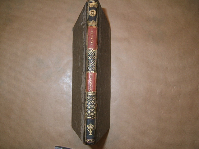
Extrait du recueil méthodique des lois, décrets, réglemens, instructions et décisions sur le cadastre de la France approuvé par le ministre des finances. Arpentage.
1811 Paris, De l'imprimerie impériale, 1811. In-8, Deux feuillets non chiffrés (faux-titre et titre),160 pages. Reliure époque demi basane noire, sos lisse, décor doré avec deux fers spéciaux, et deux pièces de titre maroquin rouge, titre or.
Referenz des Buchhändlers : 5071
|
|
|
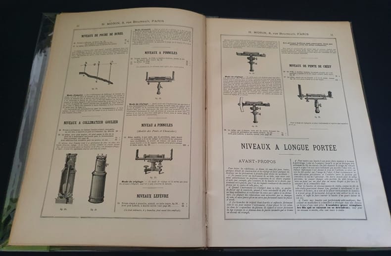
H. Morin - Instruments de précision - 1er fascicule du catalogue général
0 In4 ( 30 x 21 cm ) - cartonnage éditeur pleine percaline , titres dorés au 1er plat - 73 pages - trés nombreuses illustrations - sans date ( vers 1890) - Instrument de nivellement - niveaux - arpentage -triangulation , tachéométrie - topographie des mines - géodésie - astronomie - météorologie - marine - optique - instruments de mathématiques , etc...
Referenz des Buchhändlers : Boite14
|
|
|
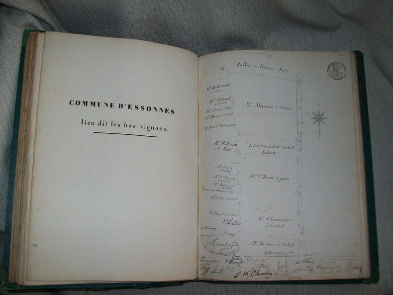
HOSPICE CIVIL DE CORBEIL. Procès-verbaux et Plans concernant la délimitation et le bornage des propriétés rurales 1846-1848. MANUSCRIT ORIGINAL.
Manuscrit in folio portant la mention "le double a été déposé au rang des minutes de Me Lognon notaire à Corbeil suivant acte du 31 décembre 1848. 3 feuillets non chiffrés (titre calligraphié, 1 tableau récapitulatif sur double page) 174 feuillets numérotés au recto, à l'encre rouge sur l'angle externe supérieur dont 88 feuillets de texte (soit 176 pages), en grande majorité rédigés recto verso avec peu de marges; plusieurs écritures, plus ou moins grandes ou serrées mais toutes bien lisibles, 3 feuillets blancs.Demi basane verte à coins, dos lisse (titre en lettres dorées sur toute sa longueur, plats de papier chagriné vert,reliure de l'époque. Orné de 3 tableaux (1 récapitulatif sur double page au début, 2 comparatifs à pleine page), 41 plans sur papier fort, certains légèrement rehaussé de bleu ou de rouge (5 sur double page, 2 numérotés 5/6 et 12/13)montrant le limites des propriétés rurales appartenant à l'hospice. Petits frottis et décolorations sur le dos, usure du papier des plats avec manques en bordure. Intérieur frais rédigé sur papier timbré, complet de son texte et de tous les plans. Petit cachet "E. Lefèvre géomètre à Sucy, Seine-et-Oise" sur certains feuillets, nombreuses signatures des propriétaires concernés par le nouveau bornage, en marge des feuillets. 1 feuillet double indépendant joint à ce manuscrit dont il est contemporain, porte le titre "Extrait du registre des délibérations de la Commission administrative de l'Hospice Civil de Corbeil" avec la mention "copie conforme" et le cachet "Corbeil, Seine-et-Oise, Mairie". Document intéressant pour cette zone géographique des environs de Paris, qui a depuis connu d'importants changements en matière d'urbanisme.
Referenz des Buchhändlers : GITh370
|
|
|
INSTRUCTION pour l'exécution du Cadastre dans le département de la Haute Savoie.
Annecy Imprimerie Dépollier et Cie 1881. In-8 broché 113pp. Illustré de nombreux fac similés de documents administratifs et 13 planches hors texte, la plupart en couleurs. Bien complet de toutes ses planches.
Referenz des Buchhändlers : GITb795
|
|
|
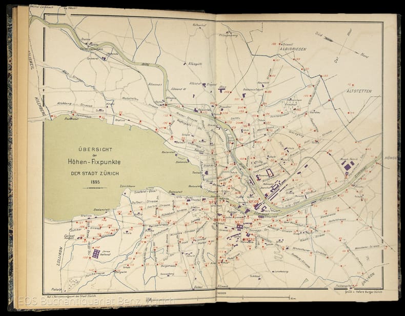
Verzeichniss der Höhen-Fixpunkte im Gebiete der Stadt Zürich. Herausgegeben vom Vermessungsamt der Stadt Zürich
Zürich, Museumsgesellschaft Zürich, 1895. 8°. 166 S., mit vielen ganzseitigen Abbildungen. Halbleinenband mit handschriftlichem Bibliotheks-Rückenschild.
Referenz des Buchhändlers : 4834DB
|
|
|
Verzeichniss der Höhen-Fixpunkte im Gebiete der Stadt Zürich. Herausgegeben vom Vermessungsamt der Stadt Zürich
Zürich, Museumsgesellschaft Zürich, 1895. 8°. 166 S., mit vielen ganzseitigen Abbildungen. Halbleinenband mit handschriftlichem Bibliotheks-Rückenschild. + Wichtig: Für unsere Kunden in der EU erfolgt der Versand alle 14 Tage verzollt ab Deutschland / Postbank-Konto in Deutschland vorhanden +, 4834DB|4834DB_2 [2 Warenabbildungen]
Referenz des Buchhändlers : 4834DB

|
|
|
"FLINDERS, MATTHEW. - SURVEYING THE COAST OF NEW HOLLAND.
Concerning the Differences in the Magnetic Needle, on Board the Investigator, arising from an Alteration in the Direction of the Ship's Head. Read March 28, 1805.
London, W. Bulmer and Co., 1805. 4to. No wrappers as extracted from ""Philosophical Transactions"" 1805. With titlepage to Phil. Transactions Part I. Pp. 186-197. Having also the titlepage to the volume (Part II, 1805). A few scattered brownspots and very faint browning to outer margins, otherwise fine and wide-margined. A small stamp to verso of titlepage.
Referenz des Buchhändlers : 45129
|
|
|
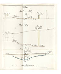
(CLAUSTHAL: MINE SURVEYING)
Manuscript on paper on mine surveying with 12 large & fine folding manuscript plates heightened in grey blue pink & yellow wash
40 leaves the final blank. Small folio 332 x 210 mm. orig. paste-paper boards spine & extremities somewhat worn uncut. Clausthal: ca. 1815.<br/> <br/> A fine and legible manuscript instructional manual on techniques and problems of mine surveying. The text is divided into five chapters: “Von der Vorbereitung zum Markscheiden†“On preparations for measuring the area in which mining may be carried out†“Von Bennenung der Gänge und Klüfte†“On the naming of seams and fissures†“Vom Observiren†“On Observations†“Vom Vermaß oder Verbestimmung eines Grubenfelds†“On measuring and defining a mining claim†and “Von Wasserfällen Wasserleitungen und Tiefbau†“On waterfalls water conduits and underground miningâ€.<br/> <br/> This manuscript was probably prepared in 1815 — plate X has the entry “Markscheide 1.7.15“ — at the newly founded mining school at Clausthal the famous mining town of the Harz Mountains in Lower Saxony the fine plates name mining locations in the area.<br/> <br/> The most attractive plates — all of which contain a number of figures — depict mine shafts mine surveying methods cartographical considerations techniques of prospecting and identification of mineral deposits problems of ownership rights and the constant problems of flooding. All the plates are finely drawn in black ink and have been heightened in grey blue pink and yellow wash.<br/> <br/> Internally fine. Stamp of Georg Riemschneider 1888-1946 “Oberbergrat†of Clausthal-Zellerfeld. unknown
Referenz des Buchhändlers : 6396
|
|
|
(Surveying) Love, John
Geossia: or The Art of Surveying and Measuring of Land Made Easy …
London: Printed for A Bettesworth and C. Hitch … and W. Innys 1731. The Fourth Edition. Diagrams. xx 196 16 4 36 8 pp. 1 vols. 8vo. Contemporary calf red leather spine label. Boards missing else clean. Signed Wm. G. Barrows. Brunswick Maine Dec. 16 1882. The Fourth Edition. Diagrams. xx 196 16 4 36 8 pp. 1 vols. 8vo. Printed for A Bettesworth and C. Hitch … and W. Innys unknown
Referenz des Buchhändlers : 223283
|
|
|
-0
Dialogo sulle stime censuarie nella pianura bolognese, inserito nel fattore di campagna. Artic. Io Vol. IIo
In 16, pp. 30. Br. ed.
|
|
|
0
MANIFESTO DEL MAGISTRATO DELLA RIFORMA RIGUARDANTE GLI STUDI, ESAMI ED ESERCIZI rispettivamente degli agrimensori, misuratori, architetti civili ed idraulici. in data de 9 Marzo 1762
In 4, pp. (4). Stemma xil. Esposizione delle modalita' di ammissione e di esame per Agrimensori, Misuratori, Architetti civili e architetti idraulici. Ai primi due era richiesta una pratica di tre anni presso un misuratore e due presso un agrimensore, agli architetti invece veniva richiesta la fede dell'aver fatto un corso di geometria e meccanica entre agli idraulici era richiesto un corso di matematica.
|
|
|
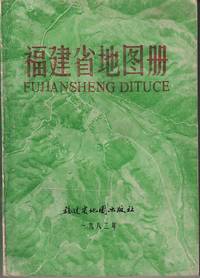
[FUJIAN PROVINCIAL BUREAU OF SURVEYING AND MAPPING] 福建省测绘局.
福建省地图册 Fujian sheng ditu ce. Atlas of the Province of Fujian.
Fujian: 福建省地图出版社. Fujian sheng ditu chubanshe. 1982. Numerous coloured maps paginated to 140pp explanatory text pages unpaginated 18.2 x 13cm text in simplified Chinese characters paperback. Maps very vivid and clear text in printed in blue a prior owner's red chop on front endpaper wrapper and title on spine worn. Good copy. . 福建省地图出版社. Fujian sheng ditu chubanshe. paperback
Referenz des Buchhändlers : 219723
|
|
|
[MANUSCRIT - CALLIGRAPHIÉ] BRIEUGNE PIERRE-FRANCOIS (NÉGRIER - SOLDAT - CORSAIRE - MAÎTRE DE PENSION A NANTES)
LIVRE DE LA VRAYE ET PARFAITE ARITHMÉTIQUE - LOURMARIN (VAUCLUSE) -1772 - [SUPERBE MANUSCRIT CALLIGRAPHIÉ EN COULEURS]
NANTES 1772 in-folio demi-vélin janséniste un Manuscrit, reliure demi-velin janséniste in-folio, dos 5 nerfs - titre manuscrit à l'encre brune façon Janséniste au dos à l'encre brune, les 3 premières pages ainsi que les deux dernières ont été habilement restaurées en marge sur un centimètre de large lors d'une restauration ancienne, texte manuscrit à l'encre brune orné de trés nombreuses lettrines calligraphiées réhaussées en couleurs sur toute les pages ainsi que des calligraphies en ornementation du texte, en bandeaux et culs-de-lampes réhaussées en couleurs (Thèmes : oiseaux divers, portraits divers, papillons divers, fleurs diverses, lapins divers etc...), orné d'un dessin à l'encre brune réhaussé en couleurs sur la moitié de la page de titre représentant "la manière de tenir la plume" et d'un dessin à l'encre brune réhaussé en couleurs représentant un portrait en pied d'un NÉGOCIANT dans son intérieur devant une Sphère Armilliaire, dessin prenant toute la dernière page , quelques légères piqûres, Table des Matières et sur les dernières pages : Rêgles d'Arithmétique, 545 pages avec une erreur de pagination (mais complet), Fait à Lourmarin, le huitième octobre 1772,
Referenz des Buchhändlers : 2750
|
|
|
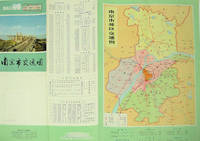
[NANJING MUNICIPAL INSTITUTE OF SURVEYING AND DESIGN]. 南京市勘测设计院.
南京市交通图. Nanjing shi jiao tong tu. Naning City Transportation Map.
No place of publication.: 江苏人民出版社.Jiangsu ren min chu ban she. 1st Edition 2nd Printing. 1977. Colour Chinese transportation map featuring the city of Nanjing capital city of Jiangsu Province and its surrounding regions. Upper side: A transpiration map of Nanjing and neighbouring counties right section with a list of names of stations buses trains coaches ferries and their addresses lower right edge tourist guide including the addresses and phone numbers of major travel agents hospitals cinemas and more left section accompanied by two tables of bus routes. On reverse: a "Map of Nanjing Municipal Transpiration Map" scale not given a chart of terminus for bus and trolley bus lower right section. Some soiling on reverse stamp of a prior dealer in Guangzhou a handwritten date of "September 17th 1977" upper side light creases good copy. Text in Chinese. Sheet measures 37.8 x 52.3cm. . 江苏人民出版社.[Jiangsu ren min chu ban she]. unknown
Referenz des Buchhändlers : 137003
|
|
|
[PROTESTANTISME - GARD] AUQUIER Paul
TRAITÉ D'ARITHMÉTIQUE - SUPERBE MANUSCRIT CALLIGRAPHIÉ EN 3 COULEURS - VERGÈZE (GARD) 1815
Vergèze 1815 in-folio Manuscrit, reliure plein veau in-folio, mais il ne reste quasiment plus rien du cuir de la reliure initiale, texte manuscrit à l'encre brune, verte et rouge orné de trés nombreuses lettrines calligraphiées en couleurs à l'encre brune, verte et rouge sur toute les pages ainsi que des Calligraphies en ornementation du texte, en bandeaux et culs-de-lampes en couleurs, la Table des matières et sur les 3 dernières pages : Règles d'Arithmétique, collationné complet, 255 pages, Fait à VERGÈZE, le 20 Septembre 1815, chez Mr J. JUEIRAL, signé Auquier (notés en bas de la dernière page avant les pages de Tables),
Referenz des Buchhändlers : 25378
|
|
|
[SURVEYING]. FLINT, Abel & GILLET, George.
A system of geometry and trigonometry: with a treatise on surveying in which the principles of rectangular surveying without plotting are explained. . . .
Hartford CT: Belknap and Hamersley 1844. 8vo. 160; 112 pp. Numerous woodcut engraved diagrams figures. Contemporary full speckled calf speckled fore-edges tan & gilt morocco spine label minor shelfwear slight rubbing occasional light foxing still an excellent copy. Third edition revised & expanded of this popular American treatise on surveying published originally in 1804 would continue to be updated and revised for over half a century. An edition of Abel Flint’s work was one of the two consulted by Abraham Lincoln while he studied to become a surveyor as it emphasized higher math including logarithms plane geometry and trigonometry. Belknap and Hamersley, unknown
Referenz des Buchhändlers : 55840
|
|
|
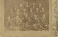
[Surveying Teams - Dakota - 1890s] Newcombe, CH. C. H.
Cabinet Card Photograph of the Staff of the Surveyor General’s Office in South Dakota
Huron 1891. Albumen photograph measuring 5 ½ x 4 inches on larger mount. Some fading very good overall. A scarce and possibly image from the post-statehood Surveyor-General’s office. Surveying in the Dakota Territory and in the early statehood period was quite difficult due to the terrain and the abundance of privately held mining claims. This photograph shows an early South Dakota office led by General B.H. Sullivan. Included in the picture is Miss Eva Jackson the Assistant Transcribing Clerk. unknown
Referenz des Buchhändlers : List2113
|
|
|
[SURVEYING -- SCIENTIFIC INSTRUMENTS]. BACHMANN, F.
Die Theorie und Praxis des Nivellirens mit besonderer Rucksicht auf Libelleninstrumente. . . .
Weimar: Bernhard Friedrich Voigt 1838. 8vo. 239 1 pp. Numerous tables. Six large folding engraved plates some hand-coloured w/ instruments and cartographic details. Contemporary quarter-tree-calf over chppng ft of spine mnr splttng to hnges foxing to textblk mnr creasng to Plate VI still good reference copy. First edition of this exceedingly scarce work on surveying detailing the equipment and leveling instruments w/ details on cartography. Bernhard Friedrich Voigt, unknown
Referenz des Buchhändlers : 38922
|
|
|
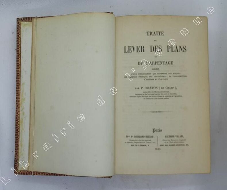
[Topographie] Breton de Champ, Paul
Traité du lever des plans et de l'arpentage : précédé d'une introduction qui renferme des notions sur l'emploi pratique des logarithmes, la trigonométrie, l'algèbre et l'optique / par P. Breton (de Champ),...
Paris, Vve Bouchard-Huzard : Gauhtier-Villars 1865 In-8 22,5 x 13,5 cm. Reliure de l’époque plein chagrin rouge, dos à nerfs encadrés de fers dorés, plats encadrés d’un quadruple filet écoinçonné doré, contre-plats encadrés de roulette dorée, tranches dorées, XXXI-595 pp., 9 planches repliées in fine, table des matières. Reliure frottée, intérieur assez frais, pages de garde poussiéreuses.
Referenz des Buchhändlers : 108539
|
|
|
[TRIGONOMETRY and SURVEYING].
18TH C SURVEYING MANUSCRIPT WITH HAND-COLORED ILLUSTRATIONS <br> Géométrique pratique.
<p>Manuscript 4to. 23.5 x 17.5 cm 2 ff. pencil sketch of arms Marlborough and blank 196 ff. and with 27 drawn folding plates many of which are colored. Bound in contemporary French calf spine gilt in six decorative compartments with title on letterpiece. Excellent with all plates drawn and many some colored in a very professional hand.<br /><br /></p><p>Very attractive early 18th-century French illustrated manuscript of practical geometry in seven books including individual sections on longimetry planimetry and stereometry—the fundamentals of precision surveying and draftsmanship. The manuscript closely follows but is not identical to Jacques Ozanam's <i>Géométrie Pratique du sr Boulenger</i> Paris 1684 which itself was a revision of <i>La Géométrie pratique </i>Paris 1640 by the mathematician Jean Boulenger. Though the work was reprinted well into the 18th C the present volume seems to follow Ozanam's 1693 edition most closely. Ozanam's book however lacks the drawn and colored figures of the present volume many of which are quite elaborate. The facade of Notre Dame is shown in an exercise for calculating the height of a wall and a segment on proportion features detailed miniature maps of the Brittany coastline identifying towns such as St. Malo and Mont St. Michel. <br /></p><p>The manuscript exemplifies the early 18th C approach to applied trigonometry—a field that by the mid-17th C was starting to resemble an exact science. Book II defines the common functions sine cosine secant etc.; Book V treats longimetric puzzles such as determining the height of a mountain or a spire or measuring the length of bodies of water; the final two books treat planimetry and stereometry including applied trigonometry—calculating the volumes of real bodies i.e. barrels pipes etc. Those sections of the manuscript that do not appear in <i>Géométrie Pratique</i>—mainly a tract on logarithms and a discussion of surveying instruments—also fall within Ozanam's oeuvre as he published a monograph on compasses in 1673 and a book of logarithmic tables and trigonometric functions in 1685.</p><p>Jacques Ozanam 1640-1717 was best known for his <i>Récréations mathematiques</i> Paris 1694 which "may be regarded as the forerunner of modern books on mathematical recreations." In addition to Boulenger's work he also revised that of Adriaan Vlacq 1600-1667 and the Jesuit mathematician Claude-François Milliet Dechalles.</p> DSB.10 pp.263-265. [France, early 18th century].
Referenz des Buchhändlers : 2805

|
|
|
[Unidentified German Army "Motorized Surveying and Map Detachment" / Vermessungs- und Karten-Abteilung Motorisiert]
UKRAINE - Two Unrecorded Nazi Wehrmacht Field Printings of Kyiv. "Blick v.d. Lissa Gora auf die Stadt Kijew" Together with: "Blick v.d. Zitadelle Lawra nach Osten und Nordosten
Kyiv 1941. Very good. Together 2 views 205 x 325 mm; 8" x 13" printed on cheap thin paper Ad 1: long closed tear through image without loss light staining creasing edges a little frayed; Ad 2: short closed tears along edges two small holes in blank area at lower left light staining. Overall in very condition suitable for exhibition and study. Tragically topical apparently unrecorded views of Kyiv being rude field printings on cheap paper likely created by Nazis during the so-called "First Battle" of Kiev Aug. 23 - Sept. 26 1941 or shortly thereafter. We are mindful that the present views are historically "toxic" but given the context of the current Russian war-crimes against the people of the Ukraine we believe that there is an urgent need for them to be preserved. <br /> <br /> The first print is a view of Kyiv looking at the city center from the south specifically from the wooded hill of Lysa Hora which had a complex fortification system. During the German occupation the fort became a military plant and tank base. Here Kyiv rises above the Dnipro river on the right. The key below identifies 22 sites mostly of military significance such as buildings bridges power plants hospitals factories churches and cloisters. To each site is assigned a code consisting of a letter or letters and a numeral or numerals: these are certainly map references i.e. K10 L10 F-G7 etc. We have been unable to locate this exact map but large bird's-eye maps of Kyiv taken by the Vermessungs- und Karten-Abteilung survive in the Kiev Polytechnic Museum and also the David Rumsey Collection. That a need for vantage-point views such as ours to accompany such a map seems self-evident. <br /> <br /> The second is a view of Kyiv taken from the Great Lavra Bell Tower in the Pechersk Lavra monastery strategically positioned in the city center looking towards the Dnieper Valley in the northeast. The key identifies 13 sites likewise militarily important but with the notable inclusion of the "Podol Judenstadt" no. 6 a Jewish neighborhood to the north of the city. <br /> <br /> Our prints may date before Nov. 3 1941 because on this day just two months into the German occupation of Kyiv a huge explosion brought down the Uspensky Sobor cathedral in the Pechersk Lavra monastery across the courtyard from the Bell Tower from which the present view was drawn.<br /> <br /> The "Motorized Surveying and Map Detachment" was an integral part of the German military and accompanied the army throughout the European and North African theater. These surveyors photographers and printers traveled with equipment to the front lines sometimes on special trains. The detachments were self-contained and had the capability to print onsite even in the most hostile conditions. Ephemeral views such as the present pair were printed in small numbers for the sole use of German occupying troops. The present prints were purchased by a Munich bookseller from a private collector in Germany along with other documents from the period.<br /> <br /> NOTA BENE: These prints were both purchased at an auction in Germany in early January 2021 i.e. BEFORE the Russian invasion of Ukraine on February 24 2022. unknown
Referenz des Buchhändlers : 3877

|
|
|
[YUNNAN PROVINCIAL BUREAU OF SURVEYING].云南省测绘局.
昆明导游图. Kunming dao you tu. Kunming Tourist Map.
No place of publication.: 广东省地图出版社.Guangdong sheng di tu chu ban she. 2nd Edition 2nd Printing. 1988. Colour folding tourist maps and transportation maps of Kunming Yunnan Province printed double sided. One side includes: seven birds-eye view maps of tourist attractions in Kunming two small maps of Kunming including surrounding region and 仙桥溶洞 "Xianqiao Karst Cave" and one photograph of Kunming CBD. On reverse: "Map of Kunming Municipal Transportation" scale not given accompanied by timetables of buses running within the city and around neighbouring regions upper right section and phone numbers of public services lower right section. Stamp of a prior dealer in Guangzhou signs of little worn on folds and corners otherwise good. Text in Chinese. Sheet measures 36.7 x 51.5cm. . 广东省地图出版社.[Guangdong sheng di tu chu ban she]. unknown
Referenz des Buchhändlers : 137006
|
|
|
A surveying
Hydrographic surveying De Groot A
Very Good. Very good blue pictorial covers stapleback. Touch of edgewear only. Inside and binding fine clean. I C S # 5751 hydrographic surveying edition 1 With 80 pps including graphs illustrations exam. unknown
Referenz des Buchhändlers : 0701MHX14MP
|
|
|
A. MANSI
DECRETO PER UN COLLEGIO D' INGEGNERI, ED AGRIMENSORI.
IN 8°, pp.10 + 2 c.b. COPERTINA IN BROSSURA D'EPOCA CON FREGI IN ROSSO.<BR>DECRETO SULL'ISTITUZIONE DI UN COLLEGIO D'INGEGNERI, ED AGRIMENSORI, IL<BR>QUALE IN TUTTO CIO' CHE RIGUARDA INSEGNAMENTO, ED ISTRUZIONE DIPENDERA' DAL DIRETTORE DEL NOSTRO REALE LICEO, E DELLA PUBBLICA ISTRUZIONE.<BR>DATO DAL NOSTRO REALE PALAZZO DI LUCCA QUESTO GIORNO 12 NOVEMBRE 1820.<BR>FIRMATO : MARIA LUISA e A. MANSI. OTTIMA CONSERVAZIONE.
|
|
|
A.Agostini
Topografia Volume II
Opera incompleta,disponibile il volume II. Brossura con copertina in cartoncino flessibile, titoli al piatto e al dorso. Segni del tempo e d'usura;piatto anteriore in parte staccato, volume scurito, macchie di conservazione, strappi alle cuffie, bordo sfilacciato, tagli bruniti ed irregolari. All'interno la legatura è lenta,alcune ingiallite, altre con sottolineature ed appunti al margine, perfettamente fruibili. Etichetta adesiva al contropiatto posteriore. Numero di pagine 370. USATO

|
|
|
AIMONETTI Cesare
Lezioni di TOPOGRAFIA ad uso degli studenti dell'Istituto Tecnico Superiore. sezione AGRIMENSURA. 2ª ed.
2 voll. in-8° (cm. 24,7x17,3), pp. 375, VI + pp. 220, (3) + appendice pp. 15. Bross. edit., piccole manc. ai dorsi, 1° volume parzialmente slegato. Stampa di tipo litografico in eleganti caratteri tipo manoscritto.
|
|
|
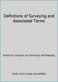
American Congress on Surveying and Mapping
Definitions of Surveying and Associated Terms
ACSM 0000-00-00. Revised Edition. paperback. Used: Good. 0.00x0.00x0.00. Buy with confidence. Excellent Customer Service & Return policy. ACSM paperback
Referenz des Buchhändlers : SONG0976599104 ISBN : 0976599104 9780976599104
|
|
|
American Congress on Surveying and Mapping
Definitions of Surveying and Associated Terms
paperback. Good. Access codes and supplements are not guaranteed with used items. May be an ex-library book. paperback
Referenz des Buchhändlers : 0976599104.G ISBN : 0976599104 9780976599104
|
|
|
American Congress on Surveying and Mapping
Definitions of Surveying and Associated Terms
ACSM 2005. Paperback. Good. Disclaimer:A copy that has been read but remains in clean condition. All pages are intact and the cover is intact. The spine may show signs of wear. Pages can include limited notes and highlighting and the copy can include previous owner inscriptions. At ThriftBooks our motto is: Read More Spend Less.Dust jacket quality is not guaranteed. ACSM paperback
Referenz des Buchhändlers : G0976599104I3N00 ISBN : 0976599104 9780976599104
|
|
|
American Congress On Surveying and Mappi
Large-Scale Mapping Guidelines
paperback. Good. Access codes and supplements are not guaranteed with used items. May be an ex-library book. paperback
Referenz des Buchhändlers : 0937294802.G ISBN : 0937294802 9780937294802
|
|
|
American Congress On Surveying and Mappi
Technical Papers Annual Convention 1990 Countdown to the 21st Century
paperback. Good. Access codes and supplements are not guaranteed with used items. May be an ex-library book. paperback
Referenz des Buchhändlers : 0944426689.G ISBN : 0944426689 9780944426685
|
|
|
American Congress on Surveying and Mapping. Meetin
Technical Papers 1986 Acsm-Asprs Annual Convention: Geographic Information Systems
paperback. Good. Access codes and supplements are not guaranteed with used items. May be an ex-library book. paperback
Referenz des Buchhändlers : 0937294705.G ISBN : 0937294705 9780937294703
|
|
|
Anonimo
La Filotecnica Ing. A. Salmoiraghi & C., Milano. Istrumenti per ingegneri e agrimensori. Catalogo n. 137
In 8 (cm 17 x 24,5), pp. 208 con illustrazioni nel testo. Brossura editoriale con un paio di aloni al piatto anteriore. Catalogo illustrato non datato, ma ascrivibile al 1912 circa, con gli strumenti della Salmoiraghi per ingegneri e agrimensori fra i quali: teodoliti, tacheometri a nonii, cannocchiali, mire o stadie, pantografi, odometri, istrumenti di meteorologia, termometri, anemometri, ecc...
|
|
|
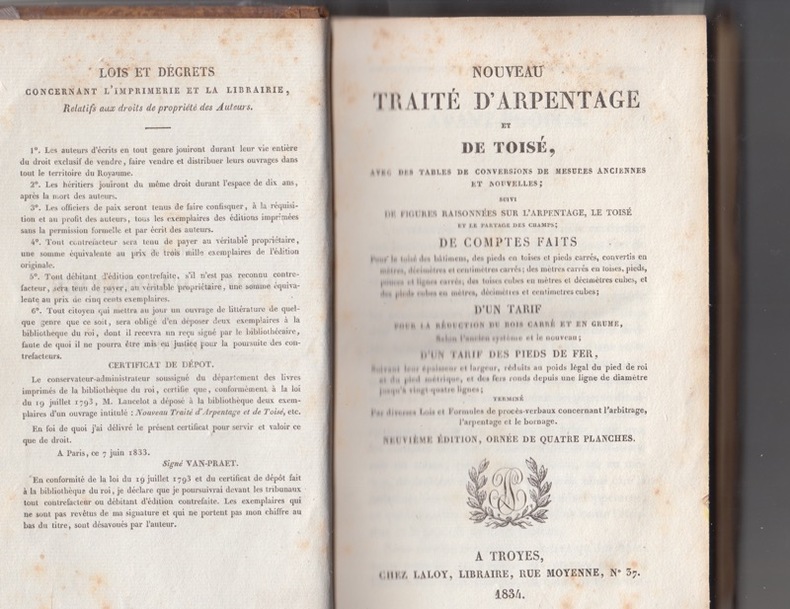
Anonyme
NOUVEAU TRAITE D'ARPENTAGE ET DE TOISE,avec des tables de conversion de mesures anciennes et nouvelles etc..-
TROYES LALOY 1834- IN8 1/2 basane dos lisse frotté-274p - 4 planches dépliantes-rousseurs éparses
Referenz des Buchhändlers : 1726
|
|
|
Anonyme
Nouveau traité d'Arpentage et de toisé, avec des tables de conversions de mesures anciennes et nouvelles; suivi de figuresraisonnées sur l'arpentage, le toisé et le partage des champs; De comptes faits (...) Huitième édition, Ornée de 4 planches.
Troyes, Laloy - 1833 - reliure sans élégance, peut-être "d'attente" , dos lissé et titrage doré, 274 pages collationnées, complet des 4 planches dépliantes en 3 volets montées sur onglet. Exemplaire d'usage, déficit de matière en pied, coins émoussés, pagination exempt de rousseur.
Referenz des Buchhändlers : 17411

|
|
|
ARPENTAGE
Arpentage, levé des plans et nivellement.
Tours, Mame; Paris, Poussielgue, 1881.
Referenz des Buchhändlers : 6796

|
|
|
ASCE Committee on Engineering Surveying
Report on Highway and Bridge Surveys
New York: American Society of Civil Engineers 1962. Paper Back. Near Fine/No Jacket. 8vo - over 7¾" - 9¾" tall. 147pp.; SC blue w/blk.; slight rub w/some sun on spine; PONstampcover; cleantight pgs. " .task of the committee.the encouragement of the use of modern techniques and high accuracy standards in surveying and mapping for planning design and construction of highways and bridges." includes errata. ASCE Manuals and Reports on Engineering Practice No.44 <br/> <br/> American Society of Civil Engineers unknown
Referenz des Buchhändlers : 025315
|
|
|
AURELIUS VICTOR Sex(tus) (relié avec : ) OTHO Johann ( et ) RUFUS Sex(tus ) ( relié avec : ) FRONTINUS ( FRONTIN ) Sext(tus) Iulius
SEX. AVRELII VICTORIS HISTORIAE ROMANAE BREVIARIUM a Jano et Saturno Urbeque condita usque ad consulatum X Constantij Aug. et Juliani Caes. III ... Ex bibliotheca Andreae Schotti , cuius etiam notae adiectae sunt . ( relié avec : ) INTRODVCTIO IN HISTORIAM ROMANAM PER IOHANNEM OTHONEM BRVGENSEM Post primam editionem innumeris locis ex fide marmorum , numismatum & veterum historiarum restituta .... ( et : ) SEX. RVFI V. C. DICTATORIS MAGISTRI MILITVM BREVIARIVM RERVM GESTARVM PO. RO. AD VALENTINIANVM AVGVSTVM Innumeris locis ad fidem antiquiss. exemplarium restitutum ( relié avec : ) SEX. IVLII FRONTINI DE COLONIIS LIB LEGIS MAMILIAE , ROSCIAE ALLENAE PEDVCAE CAPITA QUAEDAM DE AGRIS ASSIGNATIS ET CONSTITUTIONIBUS LIMITUM P. Vellei Patercvli ex lib. I Hist. Rom. itemque Vlpiani & aliorum quae ad colonias P. R. pertinent , fragmenta M. Porcii Catoniis originvm lib. I Q. Fabii Pictoris de aureo secvlo et origine vrbis Romae lib. II C. Sempronii de divisione Italiae lib. I Myrsili Lesbii de origine Italiae & Tyrrhenorum lib. II
Antverpiae ( Anvers ) ; Brugis Fland. ( Bruxelles ) pour les deux parties du 2ème ouvrage ; Parisiis. Ex officina Christophori Plantini ; Ex officina Huberti Goltzij pour les deux parties du 2ème ouvrage ; Apud Egidium Nicolaum Gillios . 1579 Numquam antehac editum ; 1565 pour les deux parties du 2ème ouvrage ; 1588 . 3 ouvrages en 1 vol. , le 2ème étant divisé en 2 parties bien distinctes in - 8 ( 11 x 16 cm ) ( poids = 300 g ) 221 (2) pp.(dont t. ) + 110 (2) pp. (dont les t. ) + 74 (14) pp. (dont t. ) . 66 portraits en médaillons dans le texte . Le 1er ouvrage contient de nombreuses pièces liminaires dont dédicace Ad Isabellam Avstriam Galliae Reginam , Epitaphivm Mariae Isabellae Galliae principis , In Avrelii Victoris historiam , Lectori S. , puis Origo Romanae a Iano et Satvrno conditoribus ... , Sex. Avrelivs Victor de viris illvsrtibvs vrbis Romae ..., Additamentvm virorvm illvstrium... , Avrelii Victoris historiae abbreviatae pars altera , Imp. Romanorvm series , In comment. de origine vrbis Romae And. Schottvs , Avctorvm , Rervm series , De avctore viror illvstrivm , Series virorvm illvstrivm , In Avr. Victoris Historiam Avgvstam notae And. Schotti , Index rervm maxime memorabilivm ... Menda . Le 2ème ouvrage , en deux parties distinctes , contient Hvbert. Goltzivs Iohanni Othoni S. P. D. , Amplissimo viro Domino D. Gvilielmo Ketelero Iohannes Otho Brvgensis S. D. , Ad generosvm bonaeque spei adolescentem Theodorvm Ketelervm Iohannis Othonis Brvgensis Praefata , In Historiam Romanam Introdvctio , puis après le 2ème titre , Sex. Rvfi V. C. dictatoris magistri militvm Breviarivm rervm gestarvm Po. Ro. , Errata , colophon . Le 3ème ouvrage contient : Sex. Ivlii Frontini De colonis libellvs , De limitibvs lex Mamilia , Roscia .... Nomina civitatem Apulia & Calabriae , P. Vellei Paterculi De coloniis ... De coloniis ex Pandect. , M. Portii Catonis ex libris originvm fragmenta , Q. Fabii Pictoris De avreo secvlo et de origine vrbis Romae .. , C. Sempronivs De divisione Italiae & origine vrbis Romae , Myrsilii Lesbii De origine Italiae et Tyrrhenorvm , Coniectvrae qvaedam Io. Opsopoei ... Index , Errata . Au 1er titre , marque typographique au compas d' or avec devise Labor et Constantia . Aux 2ème et 3ème titres , marque à la femme ( Fortuna ? ) qui vide une corne d' abondance avec devise Hvbertas aurea saerculi . Au 3ème titre , marque à trois couronnes avec le quatre de chiffre surmontant deux G affrontés et devise Hic Labor . Plein vélin rigide à petit recouvrement . Titre manuscrit de l' ouvrage principal au dos ( plus ou moins effacé ) . Tranches bleues . Pages plus ou moins jaunies , rares rousseurs , une mouillure angulaire pp. 5 - 6 du dernier ouvrage . Bon ex. . ( Collat. complet ) .
Referenz des Buchhändlers : 550
|
|
|
BACKELJAU F.
Carnet du géomètre-arpenteur (Société Belge de Géomètres établie à Anvers)
Anvers, Impr. Henri Kennes 1899 251pp.avec tables + 1 planche dépliante, 23cm., reliure cart. (dos en toile avec titre doré), bon état, W81268
Referenz des Buchhändlers : W81268
|
|
|
BACKELJAU F.
Carnet du géomètre-arpenteur (Société Belge de Géomètres établie à Anvers)
251pp.avec tables + 1 planche dépliante, 23cm., reliure cart. (dos en toile avec titre doré), bon état, W81268
|
|
|
Barré Henri,Roussel Lucien
Manuel d'arpentage et de lever des plans
Berger-Levrault et Cie Relié 1873 In-12 (12,7 x 18 cm), reliure demi-chagrin, dos lisse, XII-286 pages, bien complet des planches hors texte ; coiffes et coupes frottées, papier bruni, par ailleurs bon état général. Livraison a domicile (La Poste) ou en Mondial Relay sur simple demande.
Referenz des Buchhändlers : ga2397

|
|
|
Barrême, N(icolas)
L'arithmétique. Ou le livre facile pour apprendre l'arithmétique de soi-même, & sans maître.
Paris, Gandouin e.a., 1788. Kl.-8°. xvi, 491, [81] p. avec title et frontisp. in gravure sur bois et quelques figures geometrique dans la texte. Ldr. d. Zt. mit goldgepr. Rückenschild u. reicher floraler Rückenverg. Nouvelle édition, augmentée de plus 190 pages...
Referenz des Buchhändlers : 95621BB
|
|
|
Bartoli, Cosimo
Del modo di misurare le distantie, le superficie, i corpi, le piante, le prouincie, le prospettiue, e tutte le altre cose terrene, che possono no occorrere, a gli huomini, secondo le vere regole d'Euclide, e de gli altri piu lodati scrittori.
Venedig, Per Francesco Franceschi, 1589. Kl.-4°. 143 (von 145) Bl., (3) Bl. Mit 2 gef. Tafeln and more than 145 Holzschnitte im Text. Pappband der Zeit, mit Kleisterpapierbezug. + Wichtig: Für unsere Kunden in der EU erfolgt der Versand alle 14 Tage verzollt ab Deutschland / Postbank-Konto in Deutschland vorhanden +
Referenz des Buchhändlers : 7573CB
|
|
|
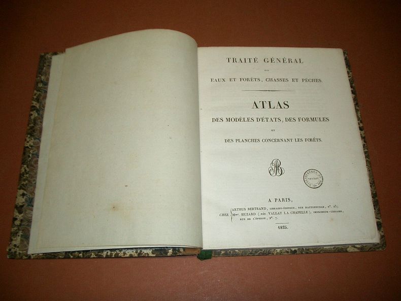
BAUDRILLART, Jacques-Joseph.
Traité Général des Eaux et Forêts, Chasses et Pêches. Atlas des modèles d'Etats, des Formules et des planches concernant les Forêts. Deuxième partie. (volume seul)
A Paris, Chez Arthus Bertrand, Mme Huzard, 1825, 1 volume de 22x28 cm environ, (1) ff., 8 pp., 49 planches (6 planches de Botanique, 21 planches concernant les Arbres, 3 planches Arpentage, 1 planche Avenues perpétuelles, 1 planche Carbonisation, 1 planche Insectes, 16 planches Bois de marine), (1) ff. Demi-reliure veau bistre et cartonnage marbré, dos lisse portant titres dorés, gardes marbrées. Feuillets non rognés. Coiffe inférieure fendue, des rousseurs, frottements sur les coupes, bon état pour le reste.
Referenz des Buchhändlers : 72674
|
|
|
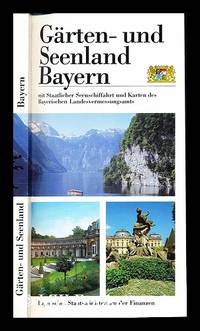
Bavarian Land Surveying Office
Garten- und Seenland Bayern mit Staatlicher Seenschiffahrt und Karten des Bayerischen Landesvermessungsamts
Bayerisches Staatsministerium der Finanzen 1995. First Edition. Softcover. Fine copy in the original color-printed stiff-card wrappers. Particularly and surprisingly well-preserved; tight bright clean and especially sharp-cornered. Physical description; 166 pages. Subjects; Bavaria. Garden and Lake District. State Lake Shipping. Maps. Bavarian Land Surveying Office. Bayerisches Staatsministerium der Finanzen paperback
Referenz des Buchhändlers : 235232
|
|
|
BENEDETTONI Giorgio
Pratica di agrimensura, stereometria e gnomonica nella quale si promuove l'uso di uno strumento fra tutti gli adoperati dagli agrimensori il piu semplice, ed il piu sicuro. All'ill. d. Adelmo Pignatelli de' principi di Belmonte abate olivetano, già vescovo di Bari, ora di Capua, d. G.B. monaco della medesima Congregazione.
8°, pp.XXIV-198 (2), mancano le 2 tavv. f.t. T. cart. color. coevo, dorso rinf. L'op. è divisa in 3 libri, corrispondenti ai 3 argomenti citati nel titolo. [Riccardi, I, 112: "buon trattatello di agrimensura, sebbene non si possa convenire coll'autore intorno all'eccellenza dello strumento da lui a tutti anteposto, chiamato cerchio icnografo, che consiste in un cerchio graduato fornito di ago calamitato a maniera di bussola topografica, con un'alidada a traguardi imperniata nel centro"].
|
|
|
BERTI, Giuseppe.
Quali sono i difetti dell'agricoltura del Dipartimento del Reno e quali i mezzi di toglierli?
In-4° (mm 215x150), pp. 43, (1). Brossura coeva in carta rosa. Ottimo esemplare. Interessante memoria che vinse il premio della Società Agraria del Dipartimento del Reno nell'anno 1810.  . .
|
|
|
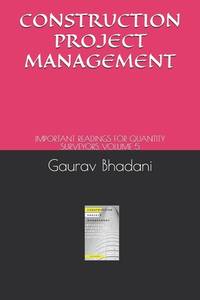
Bhadani Quantity Surveying Institute
Construction Project Management: Important Readings for Quantity Surveyors Volume 5
Paperback / softback. New. paperback
Referenz des Buchhändlers : B9798531056641 ISBN : 9798531056641 9798531056
|
|
|
BLANCHE V.-L.
Trigonométrie rectiligne et ses applications à l'arpentage
Huy, chez l'auteur-éditeur 1893 96pp.+ 8 planches dépliantes, 22cm., br.orig., 6e éd., bon état, W82097
Referenz des Buchhändlers : W82097
|
|
 Per e-mail erhalten
 Als pdf-Dokument herunterladen
 RSS feed