|
|
|
DE BERTHA A. (& RADO Samuel, d'après)
La constitution Hongroise. Précis historique d'après le dr. Samuel Rado
viii + 183pp., br.orig., 25cm., bon état, G77291
|
|
|
DE BIVORT DE LA SAUDEE J. (& Carton de Wiart, préface)
L'antireligion communiste (1917-1937)
229pp., br.
|
|
|
DE BLANCKART Charles (Baron)
Histoire moderne 1860-1880 [4 tomes]
4 tomes: 313 + 460 + 443 + 411pp., reliures cart.avec dos en toile, qqs. cachets, 24cm., bon état, G50615
|
|
|
De Blasi, Marlena
Tausend Tage in Venedig : eine Romanze mit Rezepten / aus d. Amerikan. von Marion Balkenhol.
München ; Zürich: Piper, 2007. 239 S. 8°. Ungekürzte Taschenbuchausg. - 5. Aufl. OKt. (Tb). (Serie Piper ; 4221)
Referenz des Buchhändlers : 43257
|
|
|
DE BRAY comte (& DAUDET Ernest, introd.)
Mémoires du comte de Bray. La Révolution française et la politique des puissances européennes
xvi + 493pp., 25cm., br.orig. (petits manques au dos) protégée par une couv. de papier cristal, texte frais et sans rousseurs, bon état, G86986
|
|
|
DE BRUYNE Arthur
Sinn Féin
186pp.+ 7 ills., [text in dutch]
|
|
|
De BUITELEIR, NORA
Tyrol or Not Tyrol: Theatre as History in SUDtirol/Alto Adige (Cultural Identity Studies, 25)
Paperback in like new condition. New shop stock with minor shelf-wear and score to page block foot. No other faults. AD Used
|
|
|
De BUITELEIR, NORA
Tyrol or Not Tyrol: Theatre as History in SUDtirol/Alto Adige (Cultural Identity Studies, 25)
Paperback in like new condition. New shop stock with minor shelf-wear, no faults. AD Used
|
|
|
De Caesaris Giovanni a cura di
Gli Ordini di Margarita d'Austria per li suoi Stati d'Abruzzo, del 1571 A cura di Giovanni De Caesaris
bross. edit. con titoli a due colori, piccole rotture in cop.

|
|
|
De Caro Maurizio (A cura di)\
Giancarlo Marzorati. Progetti e opere 1975-2000
illustrazioni in bianco e nero e a colori
|
|
|
DE CASTRO E ALMEIDA Virginia & DE PAMPLONA Fernando
Itinéraire historique du Portugal
Lisboa, Comité exécutif des Centenaires - Section de propagande et réception, 1940, 112pp.+ 18pp.ill.hors texte
|
|
|
De Castro Vincenzo
GRAN DIZIONARIO COROGRAFICO DELL'EUROPA COMPILATO CON ORDINE LESSICO E METODICO DAL PROFESSOR V.D.C. Volume primo (secondo)
Due volumi in 8° grande, brossura rigida editoriale, titolo ai piatti ed ai dorsi (copertura di un dorso mancante), tagli marmorizzati, sguardie, antiporte allegoriche incise da D. Gandini su disegno di Maurizio, frontespizi, LXIV, 967, 1184 pp. Importante repertorio di consultazione, notizie socioeconomiche, politiche e geografiche essenziali e stringate su ogni luogo, località, terra, fiume, città, paese europeo. Efficacissimo vademecum per lo studioso della geografia e per l'appassionato, è anche un ottimo terreno di spigolatura per il curioso. Tagli marezzati, in bello stato, qualche arrossatura dovuta al tipo di carta. Non comune

|
|
|
DE CASTRO VINCENZO
GRAN DIZIONARIO GEOGRAFICO POLITICO STATISTICO STORICO MILITARE E COMMERCIALE DELL'EUROPA COMPILATO CON ORDINE LESSICO E METODICO - in due volumi
Pagine: 968+1184 . Illustrazioni: Bella incisione con allegoria dell'Europa all'antiporta incisa da D.Gandini e disegnata da De Maurizio . Formato: 8° . Ex libris: Si timbro a secco di Cereda Antonio di Cremona . Rilegatura: Cartonato marmorizzato con dorso in pelle ed incisioni in oro . Stato: Buono . Caratteristiche: Dalle opere di Arrowsmith, Busching, Balbi, Cannabich, D'Anville, Forster, Fabri, Gaspari, Guthrie, Guibert, Goldsmith, Humboldt, Hassel, Herisson, La Martiniere, Lavallee, Marmocchi, Mannert, Masson, Moreri, Moreau de Jonnes, Malte-Brun, Mackensie, Nardi, Poirson, Pinkerton, Rampoldi, Repetti, Stein, Vosgien, Zimmermann ecc. lo studio superbo di De Castro decano e professore dell'università di Padova e del collegio nazionale di Genova. . Collana: @ .
|
|
|
DE CHATEAUBRIAND François-René
Polémique relative à l'histoire de France et au mouvement général de l'Europe
368pp., relié en couv.cart. (plats marbrés, dos en toile avec titr doré), dans les "Oeuvres de Chateaubriand", quelques rousseurs (texte bien lisible), 2 cachets, bon état, G79138
|
|
|
de Chateaubriand, Francois-René
Napoleone. Con un saggio di Giovanni Macchia. Il mito di Chateaubriand.
<p>20 cm, rilegatura editoriale in cartonato con sovracoperta illustrata, p.478. Note di E. Biré. Traduzione di Orsola Nemi.</p>

|
|
|
DE CLERCQ B.J. (red.)
Eurocommunisme en westers marxisme
Antwerpen/Meppel/Amsterdam, De Nederlandsche Boekhandel/Boom 1979, 307pp., gebroch., goede staat, G21450
|
|
|
De Cloet J. J.
RELATION D'UN VOYAGE DE BRUXELLES A VIENNE, PRAGUE ET CARLSBAD Fait en 1828.
Volume in 8º, brossura editoriale, titolo al piatto inquadrato in cornice ornamentale, occhiello, frontespizio (antico timbro con tre lune, aquila e corona), 2 cc., 71 pp., bianca finale. Straordinaria edizione originale di questo rarissimo libro di viaggi, dello scrittore e professore belga, autore anche di un meno pittoresco e più tecnico lavoro statistico economico sull'industria dei Paesi Bassi. Dedicato alla duchessa di Beaufort, questo racconto descrive un viaggio della prima metà del XIX secolo da Bruxelles a Vienna, Praga, Karlsbad e molti altri luoghi attraversati dall'autore. Se è vero che, come Cloet asserisce nella prefazione, la sua descrizione è limitata esclusivamente ai luoghi ed alle cose che vedeva con i propri occhi, anche se questo significava non includere luoghi ben noti, altrettanto vero è che tali descrizioni sono assolutamente ricchissime di particolari, non limitate a paesaggi e momumenti, ma piuttosto a luogho meno comuni e più difficilmente raggiungibili, l'interno di palazzi privati, di giardini botanici, osservatori astronomici, musei minori, importanti le descrizioni di miniere e pietre preziose, le notizie sulla coltivabilità dei terreni e sull'industriosità delle varie cittadine. Un affascinante viaggio intellettuale, capace di coinvolgere e di far rivivere i costumi, gli usi, la storia di una mitica europa. Libro assolutamente raro, stampato senza dubbio in pochissime copie non destinate alla vendita (in copertina). A parte una macchia scura (fuliggine?) al margine superiore della brossura, volume in bello stato di conservazione, rare e sporadiche fioriture della carta. In barbe.
|
|
|
de Colange, Leo
The Heart of Europe From the Rhine to the Danube: A Series of Striking and Interesting Views
Boston MA: Estes and Lauriat 1882. Book. Very Good. Hardcover. 1st Edition. 4to - over 9¾" - 12" tall. Scarce brown pebbled cloth variant also issued in green with no apparent priority lettered/illus. in gilt and black text block edged in gilt. Several areas of minor loss to cloth in both joints binding gutters otherwise minor rubbing to spine extremities and corners with mild exposure to bottom front corner. Firm binding. Clean interior beyond former owner's address inscription on upper front flyleaf. 143 pp. illus. w/ reproduced engravings both full-page and in text. Estes and Lauriat Hardcover
Referenz des Buchhändlers : 045634
|
|
|
De Colange, Leo
Picturesque European Scenery. A Series of views of the most interesting and striking landscapes of the old World.
New York, Nims, 1883. 136 S., ca. 100 Woodcuts- Illustr., Or.-Ln., Schmuckeinb., guter Zust.(good condition)
Referenz des Buchhändlers : 6365AB
|
|
|
De Coster Charles
La leggenda di Thyl Ulenspiegel A cura di Michele Rago (stampa 1991)
trad. di Umberto Fracchia n. 23 bross. edit. ill. con bandelle

|
|
|
DE COSTER L.
Explications faisant suite aux précédentes notices sur l'attribution à Charlemagne de quelques types monétaires
25pp.+ 1 planche, non coupé, br.orig., extrait de la "Revue de la numismatique belge" T.I 3e série, bel état
|
|
|
De Crescenzo, Luciano
Geschichte der griechischen Philosophie : von Sokrates bis Plotin / aus d. Ital. von Linde Birk.
Zürich : Diogenes, 1988. 244 S. Ill. 8°. Bibl.- Einbd.
Referenz des Buchhändlers : 42196
|
|
|
DE CSIKAY Paul (& GIDE Charles, préface)
L'Europe centrale économique et sociale
ix + 160pp., br.orig., 19cm., cachet, bon état, E42073
|
|
|
De Felice, Renzo
Mussolini il rivoluzionario 1883-1920
Mm 135x210 Collana "Einaudi tascabili" - Volume nella sua brossura originale, xxx-773 pagine con indice dei nomi in chiusura. Copia eccellente e mai letta, solo una picola etichetta di biblioteca dismessa in apertura. Spedizione in 24 ore dalla conferma dell'ordine.
|
|
|
De Felice, Renzo
Mussolini il rivoluzionario 1883-1920
Mm 150x210 Collana "Biblioteca di cultura storica". Volume rilegato in tela, sovraccoperta originale con tracce del tempo, xxx-773 pagine con indice dei nomi in chiusura. Opera in ottime condizioni. Spedizione in 24 ore dalla conferma dell'ordine.

|
|
|
DE FER Nicolas (1646-1720 circa)
Basle Ville Capitale du Canton du mene nom…
Pianta della città tratta dal celebre "les Forces des Europe…" pubblicazioni sulle principali città europee edita a Parigini all'inizio del XVIII secolo. Incisione in rame, in buione condizioni. Fine bird's-eye plan details the walled city and surrounding countryside. The map is oriented with north at right by a compass rose. A key at left identifies 20 important buildings and gates. Nicolas de Fer held the title of Geographer at Louis XIV's court. He was one of the most prolific publishers of plans of European cities in the late seventeenth century.

|
|
|
DE FER Nicolas (1646-1720 circa)
La Mer Mediterranee et les Costes des Estats Qui La Borne Par N. de Fer Geographe de sa Majeste Catolique et de Monseigneur
Carta tratta da: Atlas ou Recueil de cartes geographiques Dressées Sur les Nouvelles Observations de Mrs de l’Academie Royale des Sciences Par N. de Fer, Geographe de sa Majesté Catolique et de Monseigneur le Dauphin. A Paris, chez l’Auteur dans l’Isle du Palais sur le Quay de l’Orloge a la Sphere Royale. Avec privilege du Roy 1709.Acquaforte, dimensioni 360x755 mm. Titolo nel cartiglio in basso a destra; imprint editoriale nel cartiglio in alto a sinistra, che contiene anche la scala metrica: A Paris, Chez l’Auteur dans l’Isle du Palais sur le Quay de l’Orloge à a la Spere Royale. Avec Privilege du Roy. 1709. In basso a destra, la firma dell’incisore Johannes van Loon. Carta nautica del Mediterraneo pubblicata nell’Atlas ou Recueil de cartes geographiques di Nicolas de Fer, dedicata a Luigi di Francia le “Grand Dauphine”, erede al trono di Luigi XIV. Bell'esemplare in coloritura antica.Bibliografia: Mare Nostrum, a historic voyage across the Mediterranean Sea, Lussemburgo, 2003, p. 40; M. Pastoureau, Les Atlas Francais XVIe-XVIIe siècles, Parigi, 1984, pp. 167-223, FER II A (77). Etching, with fine old colour, very good condition.Map taken from: Atlas ou Recueil de cartes geographiques Dressées Sur les Nouvelles Observations de Mrs de l’Academie Royale des Sciences Par N. de Fer, Geographe de sa Majesté Catolique et de Monseigneur le Dauphin. A Paris, chez l’Auteur dans l’Isle du Palais sur le Quay de l’Orloge a la Sphere Royale. Avec privilege du Roy 1709.Title in the cartouche below right; imprint editorial in the cartouche at the top left, which also contains the metric scale: A Paris, Chez l'Auteur dans l'Isle du Palais sur le Quay de l'Orloge à a la Spere Royale. Avec Privilege du Roy. 1709. At the bottom right, the signature of the engraver Johannes van Loon.Chart of the Mediterranean published in the "Atlas ou Recueil de cartes geographiques" of Nicolas de Fer, dedicated to Louis of France the "Grand Dauphine", heir to the throne of Louis XIV.Bibliografia: Mare Nostrum, a historic voyage across the Mediterranean Sea, Lussemburgo, 2003, p. 40; M. Pastoureau, Les Atlas Francais XVIe-XVIIe siècles, Parigi, 1984, pp. 167-223, FER II A (77). S. Bifolco, "Mare Nostrum, Cartografia nautica a stampa del Mar Mediterraneo" (2020), pp. 256-257, tav. 119.

|
|
|
DE FER Nicolas (1646-1720 circa)
Les Suisses Leurs Sujets et Leurs Alliez
Bell'esemplare della mappa della Svizzera di De Fer, aggiornata e corretta dal suo successore, Guillaume Danet. Mappa superbamente dettagliata, con 13 stemmi dei cantoni svizzeri e 11 stemmi degli alleati. Nicolas de Fer (1646-1720) era il figlio più giovane del venditore di stampe e mappe parigino Antoine de Fer [morto nel 1673]. Divenne un geografo ufficiale di entrambi i re francesi e spagnoli. Dopo la sua morte nel 1720, l'attività passò ai suoi generi, Guillaume Danet e Jacques-Francois Benard. Acquaforte, con colore di contorno originale, buone condizioni. A nice example of De Fer's map of Switzerland, as updated and corrected by his successor, Guillaume Danet. Superbly detailed map, with 13 coats of arms for the Swiss Cantons and 11 coats of arms for the allies and 7 "Sujets." Nicolas de Fer (1646-1720) was the youngest son of Parisian print and map seller, Antoine de Fer [d.1673]. He became an official geographer to both French and Spanish kings. After his death in 1720, the business passed to his sons-in-law, Guillaume Danet and Jacques-Francois Benard. Etching, with original outline colour, good condition.

|
|
|
De Fer Nicolas edit.
L'Europe Suivant les Nouvelles Observations...
Raffigurazione geografica dell'Europa. Interessante notare la rappresentazione del primo meridiano considerato dai francesi passante per l'isola del Ferro

|
|
|
De Fereal V.
Misteri dell'inquisizione ed altre società secrete di Spagna – con note storiche ed una introduzione di M. De Cuendias e con estratti di una lettera relativa a quest'epoca di E. Quinet
Ottima copia.
|
|
|
de Fortemps, Jean-Luc Duvivier; Marc Fasol (photographs)
Waterloo: Battlefield for Europe
Neufchateau Belgium: Weyrich Edition 2010. Book. As New. Hardcover. 1st Edition. 8vo - over 7¾" - 9¾" tall. Glossy color pictorial boards oblong format. New/as issued color pictorial dust jacket now in mylar. 160 pp. illus. w/ color photographs. 1st ed. Very scarce. Weyrich Edition Hardcover
Referenz des Buchhändlers : 068685 ISBN : 2874890839 9782874890833
|
|
|
De Fusco Renato
Architettura come mass medium. Note per una semiologia architettonica
illustrazioni in bianco e nero
|
|
|
De Gasperi Alcide; De Gasperi M. R. (cur.)
L'Europa. Scritti e discorsi
br. «Una nuova edizione dei discorsi europei di Alcide De Gasperi, dopo più di sessanta anni dalla sua scomparsa, ci richiama a meditare quanto la sua eredità politica sia stata troppe volte dimenticata. Egli aveva iniziato e in parte percorso, assieme a Schuman e Adenauer, quella strada verso l'unità che attende ancora il nostro convinto e definitivo apporto. Nel 1954 di fronte ai Ministri degli Esteri dei sei paesi, primo nucleo di una futura unità, aveva dichiarato: "Se l'Europa non si fa oggi la si dovrà fare tra qualche lustro, ma cosa passerà tra oggi e quel giorno Dio solo lo sa". I discorsi qui raccolti restano una delle fondamenta dell'idea unitaria. Rivisti oggi nulla hanno perduto del loro smalto, né della profondità di pensiero o dello slancio coraggioso verso un avvenire tanto differente da quello che il nostro continente aveva vissuto per secoli. Riscopriamo allora come l'Unità d'Europa, perché diventi una forza reale nel mondo, abbia bisogno di quella coesione morale e quella fede nell'uomo che De Gasperi aveva tanto sognato.» (dalla Premessa di Maria Romana De Gasperi)

|
|
|
De Gaulle Charles
Memorie della speranza Il rinnovamento: 1958-1962
trad. di Lydia Magliano, Giovanni Borsa, Alberto Pozzolini, Domenico Tarizzo tela edit. con sovrac. ill.

|
|
|
de Gaulle, Charles
Lettres, notes et carnets: Mai 1969 - Novembre 1970, COMPLEMENTS de 1908 A 1968
Hardcover without jacket; gilt lettering on front board and spine. Very good condition. Text in French. Bump to spine head and a couple of other minor marks to boards. Pages are clean and sound. TA Used
|
|
|
De Girardin Emile
Journal d'un Journaliste au secret – Francia
Ottima copia gr 200
|
|
|
DE GIRARDIN Emile
L'empereur Napoléon III et l'Europe
54pp., 23cm., br., qqs.rousseurs, cachet, br.orig.(dos restauré), G68773
|
|
|
De Grada Raffaele - Le Cannu Marc - Henze Anton - Penny Nicholas B.
Giornale di viaggio in Italia. L'attività dei pittori europei in Italia nell'800: occasioni e memorie [Italiano/Français/Deutsch/English]
134 illustrazioni in nero e a colori

|
|
|
De Grada Raffaele - Scotti Aurora - Zannier Italo - Magni Marica
Pittura '800
illustrazioni a colori e in nero

|
|
|
DE GRECE, Michel.
Quand Napoléon faisait trembler l’Europe.
in-8, 402 pp., illustrations, carte, broché. Bel exemplaire. [CA33-5]
|
|
|
DE GUBERNATIS A.
STORIA COMPARATA DEGLI USI FUNEBRI IN ITALIA E PRESSO GLI ALTRI POPOLI INDO-EUROPEI. Terza edizione.
In-16, bross. muta mod., conserv. bross. orig., pp. 138. Testo in buono stato (text in good condition).
|
|
|
de Hooghe Romeyn
Carte Nouvelle De La Mer Mediterranee
Carte Nouvelle De La Mer Mediterranee ou sont Exactement Remarques tous les Ports, Golfes, Rochers, Banks, de Sable &c: a l’usage des Arméès, du Roy de la Grande Bretagne. Dressé sur le Memoires les Plus Nouveaux par le Sr. Romain de Hooge.Acquaforte e bulino, dimensioni 585x1390 mm, firmata in lastra nel cartiglio in basso, dove figura l’imprint: A Amsterdam chez Pierre Mortier. Avec Privilége 1694.Esemplare nel raro primo stato di quattro, con la data 1694 e prima della correzione del titolo, dove si legge Mediteranee al luogo di Mediterranee. Magnifica coloritura coeva, in perfetto stato di conservazione.Opera tratta da: Cartes Marines a l'Usage des Armées du Roy de la Grande Bretagne: Faites sur les Memoires les plus nouveaux, des plus experts Ingenieurs et Pilotes, et enrichies des porfils des plus fameaux Ports de Mer et villes Maritimes de l'Europe. (…) Gravéès et recuillies par le Sr. Romain De Hooge Commissaire de Sa Majesté. A Amsterdam. Chez Pierre Mortier Libraire sur le Vygen Dam. M.DC. LXXXXIII. Avec Privilege de Nos Seigneurs les Etats de Hollande et West-Frise. Monumentale carta nautica del Mar Mediterraneo di Romeyn De Hooghe (1645 - 1708). L’opera è impreziosita da 38 mappe e vedute dei principali porti del Mediterraneo, ed è decorata da numerosi galeoni, galee, figure allegoriche e mostri marini. La carta è inserita in una sezione speciale del Neptune François di Pierre Mortier, intitolata Cartes Marines a l’Usage des Armées du Roy de la Grande Bretagne; le nove carte che compongono questa sezione, tutte incise dallo stesso de Hooghe, sono descritte da Koeman come “la più spettacolare cartografia nauica mai prodotta ad Amsterdam del XVII secolo”. La carta del Mediterraneo è la più grande, decorata e spettacolare della serie. Pierre Mortier fece stampare l’atlante in onore di Guglielmo III d’Orange (in olandese Willem Hendrik van Oranje-Nassau, anche noto come Guglielmo III d’Inghilterra), re olandese sul trono britannico. Le dimensioni dell’atlante, senza precedenti, e il ricorso ad artisti del calibro di de Hooghe hanno reso questa raccolta una delle più sontuose dell’epoca. Koeman lo definisce “l’atlante nautico più costoso del periodo”, inteso più come pubblicazione spettacolare che come un reale strumento ad uso dei navigatori. La carta è conosciuta in diverse edizioni o stati: la prima stesura reca nel titolo la parola Mediteranée con una sola “R”. Il termine viene corretto successivamente, mentre nella terza stesura la data è abrasa. L’ultima edizione della tavola ha l’imprint editorial corretto in: A Amsterdam chez J. Covens & C. Mortier. Le edizioni successive alle prime due ricorrono ne Le Neptune françois, ou Atlas nouveau des cartes marines: leveés et gravées par ordre exprés du Roy, pour lª usage de ses armées de mer dans lequel on voit la description exacte de toutes les côtes de la Mer Oceane, & de la Mer Baltique, depuis la Norwege au Detroit de Gibraltar. Où sont exactement marquées les routes quªil faut tenir, les bancs de sables, rochers & brasses dªeau; & generalement tout ce qui concerne la navigation reveu et mis en meilleur ordre par les Sieurs Pene, Cassini & autres.Bibliografia: T. Campbell, Early Maps, New York, 1981, pp. 96-7; C. Koeman, Atlantes Neerlandici: Bibliography of Terrestrial, Maritime and Celestial Atlases and Pilot Books Published in the Netherlands up to 1880 Vol. IV, pp. 423-431, M. Mor 5 (9); Mare Nostrum, a historic voyage across the Mediterranean Sea, Lussemburgo, 2003, p. 38; National Maritime Museum, Catalogue of the Library - Vol. Three, Atlas & Cartography, Londra, 1971, pp. 282-284, n. 238 (38); R. Putman, Early Sea Charts, New York, 1983, pp. 22-3, tav. 7; cfr. R. Shirley, Maps in the Atlases of the British Library, Londra, 2004, pp. 1236-1241; P. Whitfield, The Charting of the Oceans: Ten Centuries of Maritime Maps, British Library, 1996, pp. 86-7. Carte Nouvelle De La Mer Mediterranee ou sont Exactement Remarques tous les Ports, Golfes, Rochers, Banks, de Sable &c: a l’usage des Arméès, du Roy de la Grande Bretagne. Dressé sur le Memoires les Plus Nouveaux par le Sr. Romain de Hooge.Etching and engraving, 585x1390, signed in the lower cartouche with the imprint: A Amsterdam chez Pierre Mortier. Avec Privilége 1694.RARE FIRST STATE, of four, dated 1694, before the correction of the title.Magnificient example with fine original colouring, in excellent condition.The map is embellished with 38 inset maps and views of the major ports and harbors of the Meditereanean Sea, and numeorus galleons, allegorical figures and sea monsters.From: Cartes Marines a l'Usage des Armées du Roy de la Grande Bretagne: Faites sur les Memoires les plus nouveaux, des plus experts Ingenieurs et Pilotes, et enrichies des porfils des plus fameaux Ports de Mer et villes Maritimes de l'Europe. (…) Gravéès et recuillies par le Sr. Romain De Hooge Commissaire de Sa Majesté. A Amsterdam. Chez Pierre Mortier Libraire sur le Vygen Dam. M.DC. LXXXXIII. Avec Privilege de Nos Seigneurs les Etats de Hollande et West-Frise. This chart is the most decorative map of the Mediterranean issued for inclusion in an atlas.This beautiful map is included in a special section of the Neptune François by Pierre Mortier, titled Cartes Marines a l’Usage des Armées du Roy de la Grande Bretagne, that contains maps engraved by de Hooghe; these charts were judged by Koeman to be the most spectacular type of maritime cartography ever produced.According to Koeman the Neptune François was: …the most expensive sea-atlas ever published in Amsterdam.. Its charts are larger and more lavishly decorated than those of any preceding book of this kind. For the engraving and etching Mortier had recruited the most qualified artists. This magnificent work was intended more as a show piece than something to be used by pilots at sea.Bibliografia: T. Campbell, Early Maps, New York, 1981, pp. 96-7; C. Koeman, Atlantes Neerlandici: Bibliography of Terrestrial, Maritime and Celestial Atlases and Pilot Books Published in the Netherlands up to 1880 Vol. IV, pp. 423-431, M. Mor 5 (9); Mare Nostrum, a historic voyage across the Mediterranean Sea, Lussemburgo, 2003, p. 38; National Maritime Museum, Catalogue of the Library - Vol. Three, Atlas & Cartography, Londra, 1971, pp. 282-284, n. 238 (38); R. Putman, Early Sea Charts, New York, 1983, pp. 22-3, tav. 7; cfr. R. Shirley, Maps in the Atlases of the British Library, Londra, 2004, pp. 1236-1241; P. Whitfield, The Charting of the Oceans: Ten Centuries of Maritime Maps, British Library, 1996, pp. 86-7. S. Bifolco, "Mare Nostrum, Cartografia nautica a stampa del Mar Mediterraneo" (2020), pp. 158-159, tav. 68.

|
|
|
DE JODE Cornelis (c. 1509 - 91)
Nova Exactissimaqve Descriptio Danvbii…
Rara carta geografica del corso del Danubio tratta dalla seconda edizione dell'atlante del De Jode, curata dal figlio Cornelis e denominata Speculum Orbis Terrae, 1593. Il foglio raffigura solo la parte occidentale del corso del Danubio. La carta venne disegnata da Christian Sgrooten.Incisione in rame, firmata in lastra dai fratelli van Deutecum, in perfetto stato di conservazione. Rare map taken from the second edition of the atlas of De Jode, edited by his son Cornelis and called Speculum Orbis Terrae, 1593. The depiction of Croatia on the map Nova exactissimaqve descriptio Danvbii, was made by Christian Sgrooten.Egraved by Lucas & Johannes van Deutecum. Copper engraving, whit full margins, in perfect condition. D. Mlinari?, J. Fari?i?, L. Miroševi? p. 163.

|
|
|
DE JODE Gerard (1509 - 1591)
Europa Totius Orbis Partium amoenissima commoda iam recens absolutaque Descriptio
Acquaforte e bulino, prima del 1573, firmata in lastra nel cartiglio da Joannes e Lucas Doetecum. Esemplare nel secondo stato, pubblicato nella prima edizione del 1578. Magnifica prova, con bellissima coloritura coeva, con margini, in perfetto stato di conservazione. Al verso, testo latino e numero di pagina in carattere romano, V. Gerard de Jode, era cartografo, incisore, tipografo ed editore nella città di Anversa, attivo all’incirca nello stesso periodo di Ortelius. Nel 1547 ottenne il privilegio per l’attività editoriale, tuttavia non fu mai in grado di rappresentare un’effettiva minaccia per il suo rivale in affari. Per ironia della sorte, pubblicò il famoso Mappamondo del rivale, in otto fogli, nel 1564. Il suo atlante più importante, lo Speculum Orbis Terrarum, oggi estremamente raro, non poté essere pubblicato fino al 1578, ovvero otto anni dopo il Theatrum Orbis Terraum di Ortelius, che aveva ottenuto il monopolio per l’editoria cartografica ad Anversa. Le carte del De Jode furono finemente tradotte su rame nel tipico stile fiammingo dai fratelli Joannes e Lucas van Doetecum, i migliori intagliatori di mappe del tempo. Alla morte di Gerard, il figlio Cornelis pubblicò, nel 1593, una ristampa accresciuta dell’atlante. - FIRST EDITIONS WITH CONTEMPORY COLOUR -Etching with engraving, before 1573, signed on plate in the title by Joannes and Lucas Doetecum. Example in the second state, published in the first edition of 1578. Magnificent proof, contemporary colour, with margins, in perfect condition. In verse, Latin text and page number in roman font, V. Gerard de Jode, was a cartographer, engraver, printer and publisher in Antwerp, active around the same period of Ortelius. In 1547 he obtained the privilege for the publishing business, but was never able to represent a real threat to his business rival. Ironically, he published a major rival of the Globe, in eight sheets, in 1564. His most important atlas, Speculum Orbis Terrarum, now extremely rare, could not be released until 1578, ie eight years after the Theatrum Orbis Terraum of Ortelius, who had obtained a monopoly for the Cartographic Publishing Antwerp. The maps of De Jode were finely translated copper in typical Flemish brothers Joannes and Lucas van Doetecum, the best engravers of maps of the time. On the death of Gerard, the son Cornelis published in 1593, a reprint of the atlas increased. The New Hollstein, The Doetecum Family part III, p. 37, 561.

|
|
|
DE JODE Gerard (1509 - 1591)
Palatinatum Superioris Seu Bavariae vera Descriptio Avtore Erhardo Reych/Wirtenberge:nsis Dvcatvs Elegans Delineatio Avtore
Acquaforte e bulino, prima del 1573. Esemplare pubblicato nella prima edizione del 1578. Magnifica prova, con bellissima coloritura coeva, con margini, in perfetto stato di conservazione. Al verso, testo latino e numero di pagina in carattere romano, XX. Gerard de Jode, era cartografo, incisore, tipografo ed editore nella città di Anversa, attivo all’incirca nello stesso periodo di Ortelius. Nel 1547 ottenne il privilegio per l’attività editoriale, tuttavia non fu mai in grado di rappresentare un’effettiva minaccia per il suo rivale in affari. Per ironia della sorte, pubblicò il famoso Mappamondo del rivale, in otto fogli, nel 1564. Il suo atlante più importante, lo Speculum Orbis Terrarum, oggi estremamente raro, non poté essere pubblicato fino al 1578, ovvero otto anni dopo il Theatrum Orbis Terraum di Ortelius, che aveva ottenuto il monopolio per l’editoria cartografica ad Anversa. Le carte del De Jode furono finemente tradotte su rame nel tipico stile fiammingo dai fratelli Joannes e Lucas van Doetecum, i migliori intagliatori di mappe del tempo. Alla morte di Gerard, il figlio Cornelis pubblicò, nel 1593, una ristampa accresciuta dell’atlante. Etching with engraving, before 1573. Exemple of the first edition published in 1578. Magnificent impression, with great contemporary coloring, with margins, in perfect condition. Latin text and page number in roman font, XX. Gerard de Jode, was a cartographer, engraver, printer and publisher in Antwerp, active around the same period of Ortelius. In 1547 he obtained the privilege for the publishing business, but was never able to represent a real threat to his business rival. Ironically, he published a major rival of the Globe, in eight sheets, in 1564. His most important atlas, Speculum Orbis Terrarum, now extremely rare, could not be released until 1578, ie eight years after the Theatrum Orbis Terraum of Ortelius, who had obtained a monopoly for the Cartographic Publishing Antwerp. The maps of De Jode were finely translated copper in typical Flemish brothers Joannes and Lucas van Doetecum, the best engravers of maps of the time. On the death of Gerard, the son Cornelis published in 1593, a reprint of the atlas increased .

|
|
|
DE JODE Gerard (1509 - 1591)
Wirtenberge:nsis Dvcatvs Elegans Delineatio Avtore Geogio Garner/Palatinatvm Svperioris Sev Bava:riae vera Descriptio Avtore
Rara carta geografica tratta dalla seconda edizione dell'atlante del De Jode, curata dal figlio Cornelis e denominata Speculum Orbis Terrae, 1593. Incisione in rame, in perfetto stato di conservazione. Rare map taken from the second edition of the atlas of De Jode, edited by his son Cornelis and called Speculum Orbis Terrae, 1593. Copper engraving, in perfect condition.

|
|
|
DE JONG Marijnke & VAN JOLE Marcelnke
The power of example: 20 years of Europa Nostra Awards, Le pouvoir de l'exemple: 20 ans prix Europa Nostra, Het voorbeeld aan de macht: 20 jaar Europa Nostra Awards
375pp., 30cm., cloth, illustrated dustwrapper, VG, [trilingual: English-French-Dutch], weight: 2.7kg., G61595
|
|
|
DE JONG Martien J.G.
Vadertaal en Moederland. Over het Nederlands in de Lage Landen en Europa
140pp., 21cm., gecart., mooie staat
|
|
|
De Jong, AP A P
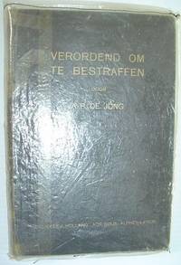
Verordend om Te Bestraffen - Bijbellezingen Over Den Profeet Elia
Netherlands: Publilsher 1930. Book. Fair. Hardcover. Reprint. 8vo - over 7¾" - 9¾" tall. 285 pages. Text in Dutch. Above-average wear. Home-made clear plastic cover protects boards. Some markings to contents. Binding intact. Year of publication uncertain - possibly 1930s. Publilsher Hardcover
Referenz des Buchhändlers : 742a5942
|
|
|
De Jong, A.P.
Verordend om Te Bestraffen - Bijbellezingen Over Den Profeet Elia
285 pages. Text in Dutch. Above-average wear. Home-made clear plastic cover protects boards. Some markings to contents. Binding intact. Year of publication uncertain - possibly 1930s?. Book

|
|
|

 Per e-mail erhalten
 Als pdf-Dokument herunterladen
 RSS feed
 Permanenter link


