|
|
|
DUDAKOV VALERIJ ALEKSANDROVIC
IL SIMBOLISMO RUSSO. SERGEJ DJAGILEV E L'ETA' D'ARGENTO NELL'ARTE. CATALOGO DELLA MOSTRA, VENEZIA, FONDAZIONE GIORGIO CINI, 29 AGOSTO - 29 NOVEMBRE 1992
numerose illustrazioni a colori e in bianco e nero
|
|
|
Dudal R.,Osmond D. A.,Tavernier R.
Carte des sols de l'Europe, 1 / 2.500.000 (2 volumes)
Organisation des Nations Unies pour l'Alimentation et l'Agriculture Dos carré collé 1967 Deux volumes in-4 (23,5 x 29,5 cm), dont un volume de notice explicative dos carré collé (126 pages) et une chemise contenant les cartes en couleurs ; manque au dos en tête du livret de notice, quelques marques d'usage et rousseurs éparses, par ailleurs assez bon état. Livraison a domicile (La Poste) ou en Mondial Relay sur simple demande.
Referenz des Buchhändlers : xa79
|
|
|
DUDLEY Robert (1573 - 1649)
Una Carta Generale del mare Mediterranio. Carta prima Generale d’Europa & Una carta dell’Arcipelago, con parte del Mare
Carta tratta da: Arcano Del Mare Di D’Ruberto Dudleo Duca Di Nortumbria e Conti Di Warvich Diuiso in libri sei. Nel primo, de' quali si tratta della longitudine praticabile in diuersi modi, d'inuenzione dell'Autore. Nel secondo, delle carte sue generali, e de' portolani rettificati in longitudine, e latitudine. Nel terzo, della disciplina sua marittima, e militare. Nel Quarto, Dell'Archittetura sua Nautica di Vascelli da guerra. Nel Quinto, Della Navigazione scientifica, e perfetta cioe Spirale ò di gran Circoli.". El volumen 2 contiene el libro sexto: "Nel sesto, Delle carte sue Geografiche, e Particolari in Fiorenze, MDCLXI.: In Firenze, Nella Stamperia di Francesco Onofri. 1646.Coppia di incisioni ad acquaforte e bulino, rispettivamente di dimensioni 435x745 e 435 x365 mm.Raro ed importante portolano del Mediterraneo. Magnifico esemplare, su carta vergata coeva, in ottimo stato di conservazione.Carta nautica del Mediterraneo con proiezione di Mercatore, disegnata dall’inglese Robert Dudley ed incisa a Firenze da Antonio Lucini. Dudley (1574-1649) era il figlio illegittimo di Robert Dudley, conte di Leicester, e cognato del famoso circumnavigatore Thomas Cavendish. Dudley si unì alla Royal Navy e condusse una spedizione in Sud America nel 1594-1595. Nel 1596, comandò la nave Nonpareil nel riuscito attacco del Conte dell’Essex a Cadice, e fu nominato cavaliere per i suoi servizi. Dopo un viaggio di alcuni anni nei Caraibi, fu condannato all’esilio in Italia, dove si stabilì nel 1605, divenendo geografo alla corte di Ferdinando I, Granduca di Toscana. A Firenze, Dudley mise a frutto la sua esperienza navale; lavorò come costruttore di navi, consulente nei progetti di costruzione di porti e delle loro fortificazioni. Contemporaneamente scrisse anche la sua opera più importante e nota: Dell’Arcano del Mare, un manuale di navigazione. Una prima versione manoscritta del testo sopravvive nel Museo di Storia Naturale a Firenze, in tre volumi, due datati 1610. Una seconda versione più completa (ca. 1636-1646) è alla Biblioteca Reale di Monaco e contiene una serie di carte manoscritte. La versione a stampa Dell’Arcano del Mare fu pubblicata a Firenze nel 1646-1648, per essere poi ristampata, come Arcano Del Mare, Nella nuova stamperia, per Giuseppe Cocchini, all'insegna della Stella. Ad istnaza di Iacopo Bagnoni, & Antonfrancesco Lucini. 1661.L’Arcano (o “Segreti del mare”) è una sorta di enciclopedia di materie nautiche - dalla costruzione navale alla navigazione e all’astronomia. Fu stampato in sei volumi che contengono un gran numero di illustrazioni, diagrammi tecnici, immagini di strumenti ecc., ma, soprattutto, una serie di 146 carte che coprono tutte le parti del mondo. L’Arcano è il primo atlante nautico costruito sulla proiezione di Mercator, particolarmente adatta alla navigazione. Le carte nautiche sono incise da Antonio Francesco Lucini e l’opera costituisce uno dei più grandi atlanti del mondo. Pubblicato per la prima volta nel 1646 quando il suo autore aveva 73 anni, non era solo il primo atlante nautico del mondo e il primo ad utilizzare la proiezione di Mercatore, ma anche il primo a mostrare la deviazione magnetica, le correnti e i venti dominanti e a esporre i vantaggi del ‘Great Circle Sailing’ - la distanza più breve tra due punti su un globo. L’atlante è diviso in sei libri, o sezioni: il primo libro tratta della longitudine; il secondo tratta degli errori nelle carte nautiche esistenti e comprende il portolano per il Mediterraneo e 15 carte generali; il terzo libro tratta della disciplina navale e militare e contempla una lunga sezione sulla tattica navale; il quarto libro descrive il metodo di progettazione e costruzione di navi e si occupa dell’architettura navale, fornendo le linee e le dimensioni delle navi; il quinto libro è interamente dedicato alla navigazione e ai metodi di misurazione della declinazione del sole e delle relative posizioni delle stel... Etching and engraving, printed on two sheets (435x745 and 435 x365 mm), with margins, very good conditions.Map of the Mediterranean Sea taken from the beutiful: Arcano Del Mare Di D’Ruberto Dudleo Duca Di Nortumbria e Conti Di Warvich Diuiso in libri sei. Nel primo, de' quali si tratta della longitudine praticabile in diuersi modi, d'inuenzione dell'Autore. Nel secondo, delle carte sue generali, e de' portolani rettificati in longitudine, e latitudine. Nel terzo, della disciplina sua marittima, e militare. Nel Quarto, Dell'Archittetura sua Nautica di Vascelli da guerra. Nel Quinto, Della Navigazione scientifica, e perfetta cioe Spirale ò di gran Circoli.". El volumen 2 contiene el libro sexto: "Nel sesto, Delle carte sue Geografiche, e Particolari in Fiorenze, MDCLXI.: In Firenze, Nella Stamperia di Francesco Onofri. 1646.A rare and important charts of the Mediterranea Sea. Dudley was the illegitimate son of Robert Dudley, Earl of Leicester, and brother-in-law of the celebrated circumnavigator Thomas Cavendish. Dudley joined the Royal Navy and led a privateering expedition to South America in 1594-1595. In 1596, he commanded the ship Nonpareil in the Earl of Essex's successful attack on Cadiz, and was knighted for his services.Dudley sought to have his legitimacy established at court, but his attempts failed, and he fled abroad, eventually settling in Florence. Dudley was summoned to return to England but refused and was stripped of his titles and estates.In Florence, Dudley put his naval experience to good use; he worked as a ship-builder, consulted on construction projects for harbours and their fortifications, while also writing his magnus opus, a handbook of navigation, ‘Dell’Arcano del Mare’.An early manuscript version of the text survives in the Museo di Storia Naturale, in Florence, in three volumes, two dated 1610. A second, more complete version, dated [ca.1636-1646?] is in the Royal Library, Munich, containing a series of manuscript charts.The printed version, ‘Dell’Arcano del Mare’ was published in Florence in 1646-1648 and re-issued as ‘Arcano Del Mare’ in Florence in 1661. The ‘Arcano’ (or ‘Secrets of the Sea’) was printed in six volumes, an encyclopaedia of matters marine from ship-building through to navigation and astronomy, containing large number of illustrations, technical diagrams, pictures of instruments and so on, but more importantly, a series of 146 charts covering all parts of the world.The ‘Dell’Arcano’ is the first printed sea atlas of the world, and the charts form the first series constructed on the Mercator projection, a projection particularly suited to navigation. However, the ‘Dell’Arcano’ was too large for use on board ship, and too elaborate. The charts were engraved by Antonio Francesco Lucini, and are performed in an elaborate style, the lettering with long flourishes, elaborate compass roses and so on, an expensive production, in the preparation of which Lucini later noted that he had taken 12 years and used 5,000 pounds of copper.The charts are puzzling. Some are clearly drawn from Dudley's own experiences, such as those of northern South America; some from other English sources, presumably communicated to him by brother officers at some point in his career; and some from charts that he owned, but the whole contains remarkable charts of all parts of the world, and not all the sources can be identified.After his death, Dudley's library passed to Ferdinand II, Grand Duke of Tuscany, and much of it resides in the Bibliotheque Nazionale, Florence, including an interesting and important group of English manuscript charts, drawn by John Daniel, while the scientific instruments are to be found in the Museo Galileo, in the same city.Dudley’s ‘Dell’Arcano’ is one of the most important of all sea atlases and yet it had no heirs and, seemingly, no influence, so it stands alone, a unique and as yet little understood masterpieceBibliografia: V. Arri... S. Bifolco, "Mare Nostrum, Cartografia nautica a stampa del Mar Mediterraneo" (2020), pp. 196-197, tav. 85.

|
|
|
Dufays, Sophie (Herausgeber), Dominique (Herausgeber) Nasta und Marie (Herausgeber) Cadalanu
Connait-on la chanson? : usages de la chanson dans les cinémas d'Europe et d'Amérique Latine depuis 1960. Repenser le cinéma ; vol. 9
Bruxelles ; Bern ; Berlin ; Wien : P.I.E. Peter Lang, [2019]. 340 Seiten : Illustrationen, Noten ; 21 cm, 427 g Broschur
Referenz des Buchhändlers : 1126084
|
|
|
Duff, Charles
A Handbook on Hanging
London: John Lane The Bodley Head Ltd. 1938. Being a short introduction to the fine art of Execution and containing much useful information on Neckbreaking Throttling Strangling Asphyxiation Decapitation and Electrocution; as well as Data and Wrinkles for Hangmen an account of the late Mr. Berry's method of Killing and his working list of Drops; to which is added a Hagman's Ready Reckoner and certain other items of interest. New and enlarged edition. Hardcover with lightly bumped and rubbed spine ends and leading corners. Discoloration of foot of spine. Tiny surface chip to upper edge of front board. Lightly water damaged grubby scratched and edgeworn dust jacket has creased and nicked spine ends and slightly chipped leading corners. Page edges are roughly cut. Bookplates on front pastedown and FEP. Noticeable age spotting to pages. Binding is sound and text remains clear throughout. T. Hardcover. Good/Good. Used. John Lane The Bodley Head Ltd. Hardcover
Referenz des Buchhändlers : 419088
|
|
|
Duff, Charles
A Handbook on Hanging
Being a short introduction to the fine art of Execution, and containing much useful information on Neckbreaking, Throttling, Strangling, Asphyxiation, Decapitation and Electrocution; as well as Data and Wrinkles for Hangmen, an account of the late Mr. Berry's method of Killing and his working list of Drops; to which is added a Hagman's Ready Reckoner and certain other items of interest. New and enlarged edition. Hardcover with lightly bumped and rubbed spine ends and leading corners. Discoloration of foot of spine. Tiny surface chip to upper edge of front board. Lightly water damaged, grubby, scratched and edgeworn dust jacket has creased and nicked spine ends and slightly chipped leading corners. Page edges are roughly cut. Bookplates on front pastedown and FEP. Noticeable age spotting to pages. Binding is sound, and text remains clear throughout. T Used

|
|
|
Duff, David
Eugenie and Napoleon III
Very good first edition hardcover in like, unclipped plastic-protected dustjacket. Part of an exceptional private collection recently purchased.
|
|
|
Duff, Nora
Matilda of Tuscany: La Gran Donna d'Italia
London: Methuen and Co. 1909. Ex-Library. VG. Decorative Cloth. First Edition. 8vo - over 7¾" - 9¾" tall. Burgundy cloth lettered decorated and bordered in gilt. Ex-library copy never circulated and thus showing only light shelf wear with call label on lower spine presentation book plate mounted on front pastedown stamped title page circulation card mounted on rear pastedown unstamped otherwise lightly rubbed corners and spine extremities. Original "Imported by" tag from Dutton laid in. xi322 pp. 47 pp. publisher's catalog at rear illus. w/ b&w plates. Nicely preserved with only cosmetic ex-libris defects. Very scarce. Methuen and Co. Hardcover
Referenz des Buchhändlers : 027994
|
|
|
Dufferin Lord Frederick Temple Hamilton Temple Blackwood
Contributions to an Inquiry into the State of Ireland
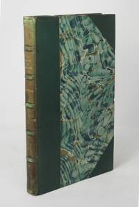
London: John Murray 1866. First Edition. Hardcover. Very good. 8vo 226 pp bound in 3/4 green leather and green marbled boards top edge gilt green silk ribbon bookmark bound in. Binding signed William Taylor Morrell. Small bump to top edge of rear board light scuffing to leather foxing to first and last few leaves otherwise clean and sound. Armorial bookplate of William Ruddell Clarke of Trabolgan County Cork Ireland on front pastedown. "Clarke 1870-1937 inherited Trabolgan a large Georgian house and the surrounding estate of 1500 acres from his father in 1911. After his death the estate was purchased by the Irish Land Commission" National Library of Australia. Dufferin an Irish peer and landowner became concerned with the sufferings of Irish tenants in the wake of the great famine leading him to take initiatives designed to relieve their distress on his own estates. This is one of several works he published on Irish land tenure issues. John Murray hardcover books
Referenz des Buchhändlers : 20280
|
|
|
Dufferin, Lord (Frederick Temple Hamilton-Temple-Blackwood)
Contributions to an Inquiry into the State of Ireland
London: John Murray 1866. First Edition. Hardcover. Very good. 8vo 226 pp bound in 3/4 green leather and green marbled boards top edge gilt green silk ribbon bookmark bound in. Binding signed William Taylor Morrell. Small bump to top edge of rear board light scuffing to leather foxing to first and last few leaves otherwise clean and sound. Armorial bookplate of William Ruddell Clarke of Trabolgan County Cork Ireland on front pastedown. "Clarke 1870-1937 inherited Trabolgan a large Georgian house and the surrounding estate of 1500 acres from his father in 1911. After his death the estate was purchased by the Irish Land Commission" National Library of Australia. Dufferin an Irish peer and landowner became concerned with the sufferings of Irish tenants in the wake of the great famine leading him to take initiatives designed to relieve their distress on his own estates. This is one of several works he published on Irish land tenure issues. John Murray hardcover
Referenz des Buchhändlers : 20280
|
|
|
Duffey, Eric [Hrsg.]
Naturparks in Europa. Ein Führer zu den schönsten Naturschutzgebieten von Skandinavien bis Sizilien.
Stuttgart, Hamburg, München, Deutscher Bücherbund, ca. 1983. 31 cm, 287 Seiten, mit zahlreichen Abbildungen und Karten, olivgrüner Pappband in Leinenstruktur, goldgeprägter Rückentitel, Original-Schutzumschlag. Lizenzausgabe leichte Gebrauchsspuren, gut erhalten.
Referenz des Buchhändlers : 8834AB
|
|
|
Duffy, Chritopher
Instrument of War: The Austrian Army in the Seven Years War
Chicago Illinois U.S.A.: Emperor's Press 2000. 493pp/illus/maps. Details the organization structure life in and operations of the Austro-Hungarian Army in the Seven Year's War Clean. First Edition. Hard Cover. Near Fine/Very Good. Folio - over 12" - 15" tall. Emperor's Press Hardcover
Referenz des Buchhändlers : 012481 ISBN : 1883476194 9781883476199

|
|
|
Duffy, Christopher
THE FORTRESS IN THE AGE OF VAUBAN AND FREDERICK THE GREAT 1660-1789 : Siege Warfare Volume II
Routledge & Kegan Paul 1985. 318pp. Tall maroon hardback with DJ VG indices glossary b&w photos and illustrations text is free of marks Volume II Only Explains the influence of the fortress in wars of Bourbon Habsburg and Hohenzollern The fortress in the age of Vauban and Frederick the Great 1660-1789 . First Printing. Hard Cover. Very Good/Very Good. Routledge & Kegan Paul Hardcover
Referenz des Buchhändlers : w160621307 ISBN : 0710096488 9780710096487
|
|
|
Duffy, Eamon
Die Päpste : die große illustrierte Geschichte / aus d. Engl. von Eva Ambros...
München : Droemer Knaur, 1999. IX, 324 S. zahlr. Ill., Kt. 4°. Deutschsprach. Ausg. Bibl.- Einbd.
Referenz des Buchhändlers : 41927
|
|
|
DUFOUR A. H.
Carta itineraria dell’Europa indicante i limiti attuali degli stati disegnata da A. H. Dufour, geografo. Incisa e pubblicata da Giocondo Regazzoni.
Milano, Artaria, 1866. (mm. 900 x 1200). Carta geografica dell’Europa, contenuta nella sua custodia editoriale.
|
|
|
Dufour A. H. dis. – Reynaud inc.
Principales communications du centre de l’Europe avec l’Italie
Carta geografica dell’Italia e centro Europa rappresentante le principali vie di comunicazione

|
|
|
DUFOUR A.H
Atlas classique et universel de géographie ancienne du moyen âge et moderne dressé pour l’intelligence des cours d’histoire et de géographie par DUFOUR corrigé et augmenté par Charles PICQUET
petit in folio demi-chagrin rouge à nerfs titre et fers dorés..Titre,1 feuillet de table,XI,60 cartes couleurs, certaines sur double page montées sur onglets chaque carte est accompagnée d’une texte descriptif sur 2 colonnes de 2 à 4 pages.BARTHELEMIER J. Charles PICQUET 1857 rousseurs en début de volume sinon très bon état d’ensemble ;
Referenz des Buchhändlers : 2524
|
|
|
Dufour Auguste Henri 1795-1865
Europe de l'an 410 à l'an 519 de J. C.
Carta geografica, antica ed originale, in coloritura coeva che rappresenta l'Europa dall'anno 410 al 519 dopo Cristo. La mappa proviene dall'atlante geografico universale per servire la storia universale della chiesa cattolica. Autore: Dufour Auguste Henri 1795-1865. Luogo: Europa. Anno: 1861. Tecnica: litografia. Dimensioni: 430x570 il foglio. Piega editoriale

|
|
|
Dufour Auguste Henri 1795-1865
Europe de L'an 519 à l'an 771 de J. C.
Carta geografica, antica ed originale, in coloritura coeva che rappresenta la divisione da l'anno 519 al 771 dopo Cristo. La mappa proviene dall'atlante geografico universale per servire la storia universale della chiesa cattolica. Autore: Dufour Auguste Henri 1795-1865. Anno: 1861. Tecnica: litografia. Dimensioni: 430x570 il foglio. Piega editoriale

|
|
|
Dufour Auguste Henri 1795-1865
Europe moderne
Carta geografica, antica ed originale, in coloritura coeva che rappresenta l'Europa moderna e contemporanea. La mappa proviene dall'atlante geografico universale per servire la storia universale della chiesa cattolica. Autore: Dufour Auguste Henri 1795-1865. Luogo: Europa. Anno: 1861. Tecnica: litografia. Dimensioni: 430x570 il foglio. Piega editoriale

|
|
|
Dufour Auguste Henri 1795-1865
Europe occidentale de 1492 à 1519 de J. C.
Carta geografica, antica ed originale, in coloritura coeva che rappresenta l'Europa occidentale dal 1492 al 1519 dopo Cristo. La mappa proviene dall'atlante geografico universale per servire la storia universale della chiesa cattolica. Autore: Dufour Auguste Henri 1795-1865. Luogo: Europa occidentale. Anno: 1861. Tecnica: litografia. Dimensioni: 430x570 il foglio. Piega editoriale

|
|
|
Dufour Auguste Henri 1795-1865
Europe occidentale de 962 à 1492 de J. C.
Carta geografica, antica ed originale, in coloritura coeva che rappresenta l'Europa occidentale dal 962 al 1492 dopo Cristo. La mappa proviene dall'atlante geografico universale per servire la storia universale della chiesa cattolica. Autore: Dufour Auguste Henri 1795-1865. Luogo: Europa. Anno: 1861. Tecnica: litografia. Dimensioni: 430x570 il foglio. Piega editoriale

|
|
|
Dufour Emile - Dufai Alexandre
Il cavalocchio - Il commissario
trad. di Roberto Braccesi in 24°, bross. edit. ill., 2 macchie in cop.
|
|
|
DUFOUR R.
Van de Bosnische crisis tot Serajewo. De internationale verhoudingen van 1909 tot 1914 (28 juni)
Utrecht, Kemink 1935 194pp.met 2 kaarten (waarvan 1 uitvouwbaar), 24cm., goede staat, G74804
Referenz des Buchhändlers : G74804
|
|
|
DUFOUR R.
Van de Bosnische crisis tot Serajewo. De internationale verhoudingen van 1909 tot 1914 (28 juni)
194pp.met 2 kaarten (waarvan 1 uitvouwbaar), 24cm., goede staat, G74804
|
|
|
DUFOUR, A. H. - DYONNET, C. H.
Allemagne Occidentale.
Tratta dal "Grand Atlas Universel Physique, Historique et Politique de Géographie Ancienne et Moderne..." (Abel Pilon Éditeur, Paris, 1865 circa), un atlante in folio massimo composto di 40 grandi tavole realizzate a doppia pagina e incise su acciaio (Dressée par A. H. Dufour - Gravée par Ch. Dyonnet), incisione in colore d'epoca, cm 60 x 82 circa. Alcuni normali strappi marginali date le notevoli dimensioni e il tipo di carta, buono lo stato di conservazione.
|
|
|
DUFOUR, A. H. - DYONNET, C. H.
Carte de l' Empire Francaise 1812.
Tratta dal "Grand Atlas Universel Physique, Historique et Politique de Géographie Ancienne et Moderne..." (Abel Pilon Éditeur, Paris, 1865 circa), un atlante in folio massimo composto di 40 grandi tavole realizzate a doppia pagina e incise su acciaio (Dressée par A. H. Dufour - Gravée par Ch. Dyonnet), incisione in colore d'epoca, cm 60 x 82 circa. Alcuni normali strappi marginali date le notevoli dimensioni e il tipo di carta, buono lo stato di conservazione.
|
|
|
DUFOUR, A. H. - DYONNET, C. H.
Carte Générale de l'Europe Actuelle.
Tratta dal "Grand Atlas Universel Physique, Historique et Politique de Géographie Ancienne et Moderne..." (Abel Pilon Éditeur, Paris, 1865 circa), un atlante in folio massimo composto di 40 grandi tavole realizzate a doppia pagina e incise su acciaio (Dressée par A. H. Dufour - Gravée par Ch. Dyonnet), incisione in colore d'epoca, cm 60 x 82 circa. Alcuni normali strappi marginali date le notevoli dimensioni e il tipo di carta, buono lo stato di conservazione.
|
|
|
DUFOUR, A. H. - DYONNET, C. H.
Europe en 1789.
Tratta dal "Grand Atlas Universel Physique, Historique et Politique de Géographie Ancienne et Moderne..." (Abel Pilon Éditeur, Paris, 1865 circa), un atlante in folio massimo composto di 40 grandi tavole realizzate a doppia pagina e incise su acciaio (Dressée par A. H. Dufour - Gravée par Ch. Dyonnet), incisione in colore d'epoca, cm 60 x 82 circa. Alcuni normali strappi marginali date le notevoli dimensioni e il tipo di carta, buono lo stato di conservazione.
|
|
|
DUFOUR, A. H. - DYONNET, C. H.
Europe sous Charles - Quint.
Tratta dal "Grand Atlas Universel Physique, Historique et Politique de Géographie Ancienne et Moderne..." (Abel Pilon Éditeur, Paris, 1865 circa), un atlante in folio massimo composto di 40 grandi tavole realizzate a doppia pagina e incise su acciaio (Dressée par A. H. Dufour - Gravée par Ch. Dyonnet), incisione in colore d'epoca, cm 60 x 82 circa. Alcuni normali strappi marginali date le notevoli dimensioni e il tipo di carta, buono lo stato di conservazione.
|
|
|
DUFOUR, A. H.:
Carte de l’Europe dressée par A.H. Dufour.
Paris, Mme Vve Turgis, et a Toulouse, 1851, 62x82 cm, carte gravée dans une cadre typographique, pays aux frontières coloriées 1 feuille, légèrement bruni un peu plus aux bords.
Referenz des Buchhändlers : 110605aaf
|
|
|
DUFOURCQ Charles-Emmanuel
La vie quotidienne dans l'EUROPE Médiévale sous domination arabe.
Hachette Vie Quotidienne 1978 Hachette, Coll. Vie Quotidienne, 1978, 287 p., broché, environ 20x13cm. Haut et bas du dos légèrement frottés, une signature sur la page de titre. Bon état pour le reste.
Referenz des Buchhändlers : 118855
|
|
|
DUFRESNE E.
Davos : une station d'hiver pour les phthisiques dans les Hautes Alpes
- Imp. de James Attinger, Neuchâtel 1879, 10x16,5cm, broché. - Edition originale imprimée à petit nombre de ce tiré à part du Globe, journal de la Sté de géographie de Genève. Deux petits trous sans gravité sur la page de titre, un léger manque angulaire sur le deuxième plat, agréable état intérieur. Rare. [ENGLISH DESCRIPTION ON DEMAND]
|
|
|
Duggen, Hans [Hrsg.]
Europa: Eine Frage des Geldes?. Hans Duggen ; Göttrik Wewer (Hrsg.), Altenholzer Schriften ; Bd. 1
Opladen : Leske und Budrich, 1998. 100 S. ; 21 cm kart.
Referenz des Buchhändlers : 112531

|
|
|
DUHAMEL (Georges).-
Mon Europe. Avec quatre planches hors-texte tirées en héliogravure.
P., Flammarion (Collection "Hier et Aujourd'hui"), 1936, in 8° broché, 127pp. ; couverture illustrée.
Referenz des Buchhändlers : 31653
|
|
|
DUHAMEL Georges
Géographie cordiale de l'Europe
PARIS, Mercure de france - In-8 Broché - Surgé à grandes marges - ex. numéroté - 279 pages - Très propre;
Referenz des Buchhändlers : 2225
|
|
|
DUHAMEL Georges
Géographie cordiale de l'Europe
PARIS, Mercure de france - In-8 Broché - Surgé à grandes marges - ex. numéroté - 279 pages - Très propre
|
|
|
DUHAMEL Georges
Géographie cordiale de l'Europe.
Broché. 283 pages. Rousseurs.
|
|
|
DUHAMEL Georges
Géographie cordiale de l’Europe
in 12 broché, faux-titre, titre, 279 pages, 1 page de table édition originale numérotée sur vergé pur fil Lafuma. Mercure de France 1931. Très bon état
Referenz des Buchhändlers : 10698

|
|
|
DUHAMEL Georges
Mon Europe. Avec 4 planches hors-texte en héliogravure.
Broché. 127 pages.
|
|
|
DUHAMEL Georges.
Géographie cordiale de l'Europe
con una carta n.t.
|
|
|
Duhamel, Georges; Hoppe, N. (Translator)
The White War of 1938
109 pages. Author offers his fascinating and prescient views of what would befall Europe soon after publication of this work. Foxing to endpapers and edges. Somewhat above-average wear to book. Binding intact. Above-average wear to dust jacket which is now preserved in glossy new archival-grade Brodart. A worthy reading copy. Book

|
|
|
Duhic, D
Sava. Potamoloska studija.
Beograd, 1957. M. 2 Ktn. u. 24 Abb. u. Skizzen. 159 S. (Srpska Akad. Nauka 275/12).
Referenz des Buchhändlers : 108785
|
|
|
Dujowich, M. J.
ZANGEN FUN MAYN FELD
1st edition. Original boards. 8vo. 247 pages. 21 cm. In Yiddish. Title translates to Songs of my Field: Memories of my Exhausted life. Title on title page verso: Espigas de mi campo. Dujowich (1873-1951). SUBJECTS: Jews -- Russia -- Biography. OCLC lists 16 copies worldwide (OCLC: 12385305). Wear to boards. Pages browning. Otherwise Good Condition. (YID-40-96-L-'x)
|
|
|
Dukes, Jack R & Remak, Joachim
Another Germany: A Reconsideration of the Imperial Era
Boulder CO.: Westview Press 1988. Scholarly highly acclaimed text presents a detailed interpretation of the overwhelmingly negative tenor of Wilhemian historiography and analysis of key instiitutions and events which illustrates positive elements in pre-1914 German history. Includes a critical bibliography. 250 pgs. Publisher's stamp on front endpaper. Dustjacket has a minor small scrape on the rear cover otherwise as new in mylar. First Edition. Hard Cover. As New/Very Good. 8vo - over 7¾" - 9¾" tall. Westview Press Hardcover
Referenz des Buchhändlers : EH-12 ISBN : 0813372658 9780813372655
|
|
|
Dukes, Paul (ed.)
Russia and Europe (A History Today Book)
In the 1990s, the USSR's relationship with Europe is an urgent and important question not only for historians, but for everyone concerned with world affairs. For centuries there have been passionate advocates of the association of Russia with Europe, and of its essential apartness - of "Holy Russia" or of a material antithesis. In this collection of essays, historians from Europe, America and the Soviet Union examine this complex and paradoxical theme. Used
|
|
|
Dulaure, J. A
Histoire physique, civile et morale de Paris, depuis le premiers temps historiques jusqu'a nos jours.
Paris, Guillaume, 1829. 4ième édition. 10 Bände. Mit 84 Stahlstichen. Halblederbände der Zeit mit Rückentiteln und reicher Rückenvergoldung. 10 Bände.
Referenz des Buchhändlers : 5724AB
|
|
|
Dulaure, J. A
Histoire physique, civile et morale de Paris. Nouv. ed. augmentée de notes nouvelles et d'un appendice contenant des details desriptifs et historiques sur tous les monuments récemment élevés dans la capitale par J.-L. Belin.
Paris, Dutetre, 1853-56. 4 Bände. Gr. 8°. Mit 1 farbigen Frontispiz, 55 Stahlstichtafeln und 1 gefalteten Karte. HLedbde mit Rückentitel und Rückenvergoldung. - Schöne Reihe. 4 Bände.
Referenz des Buchhändlers : 2906AB
|
|
|
Duller, Eduard
Die malerischen und romantischen Donauländer. Nachdr. d. Ausg. Leipzig 1840
Hildesheim, New York : Olms, 1977. 480 S. : Ill. 8° , Hardcover/Pappeinband mit OU
Referenz des Buchhändlers : 136528

|
|
|
DULOIR ..
Viaggio di Levante del Signor di Loir, nel quale si hanno molte notizie della Grecia, del Dominio del Gran Signore, della Religione, e de' costumi de' suoi Sudditi, & altre particolarità non descritte da Pietro della Valle, aggiontovi il viaggio d'Inghilterra del Signor di Sorbiere, in cui si narrano molte cose intorno alle scienze, e relogione, & altre materie curiose (...).
In-16°, legatura moderna in mezza pergamena con punte, cc. num. 3, cc. non num. 3, pp. 438, cc. non num. 9 di Indice (ultime 6 mancanti). Alone a un centinaio di pagine, per circa metà della superficie del foglio; piccoli fori di tarlo che non interessano il testo, e altre tracce del tempo. Copia da studio. Interessante resoconto del viaggio, in dieci lettere indirizzate a vari personaggi. Duloir s'imbarcò a Marsiglia nel 1639, alla volta di Malta; passando per Smirne ed Efeso giunse a Costantinopoli, dove assistette all'intronizzazione del Sultano Ibrahim; da qui prese la via della Grecia e, passando per Corinto, il Peloponneso, Corfù, Zante, Ragusa, la Dalmazia, l'Istria giunse a Venezia. Da p. 321 alla fine il 'Viaggio d'Inghilterra del Signor di Sorbière', di Samuel Sorbière (1615-1670).

|
|
|

 Per e-mail erhalten
 Als pdf-Dokument herunterladen
 RSS feed
 Permanenter link


