|
Mexico. Secretaria de Energia, Minas e Industria Paraestatal, Subsecretaria de Minas e Industria Basica; Consejo de Recursos Min
Geological-mining monograph of the state of Zacatecas
Pachuca Mexico: Consejo de Recursos Minerales 1992 Book. Near Fine. Hardcover. 1st US Ed. Heavy large format geological report 1.5 lg/ 5 lbs 155 p. illu charts col large format fold our maps in rear pockets.s. Consejo de Recursos Minerales hardcover
Référence libraire : 043323 ISBN : 9686710078 9789686710076
|
|
|
MEYER (Jean-Charles)
Au Cartahu.
Les cartes postales anciennes racontent la vie quotidienne des Marins. Préface du Contre-Amiral (C.R.) Alex Wassilieff. Nice, Éditions SERRE, 1984. In-4 (28x22cm) cartonnage éditeur sous jaquette illustré. 125pp.
Référence libraire : WOC-1903

|
|
|
MEYER JEAN-CHARLES
AU CARTAHU LES CARTES POSTALES ANCIENNES RACONTENT LA VIE QUOTIDIENNE DES MARINS
Editions Serre 1984 125 pages 0x0x0cm. 1984. Reliure Editeur avec jaquette. 125 pages. Le livre 'Au Cartahu' de Jean-Charles Meyer utilise des cartes postales anciennes pour illustrer et raconter la vie quotidienne des marins. Il est préfacé par le contre-amiral Alex Wassilieff
Référence libraire : 11255

|
|
|
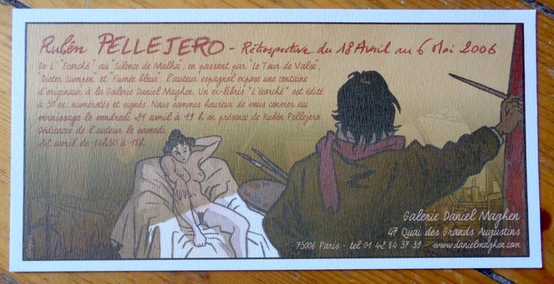
Meynet Félix:
Rétrospective du 18 avril au 6 mai 2006.
Galerie Daniel Maghen, 2006. Carton publicitaire au format 20 x 10 cm.
Référence libraire : 8565
|
|
|
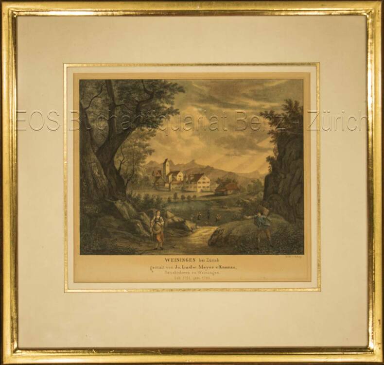
Meyer, Johann Ludwig von Knonau (1705–1785):
Weiningen bei Zürich.
Kol. Lithographie von T. Rey. Bildausschnitt: 19 x 22 cm. Rahmen: 33,5 x 35 cm.
Référence libraire : 696DG
|
|
|
MEYER, Cornelius / FALDA, G.B.
Le Paludi Pontine delineate da Cornelio Meyer et novamente intagliate da Gio.Bat. Falda
Carta topografica a stampa, cm. 49,5 x 26: nel 1677, per ordine di papa Innocenzo XI, Meyer e l’abate Innocenzo Boschi perlustrarono le paludi pontine. Boschi era stato incaricato dalla Camera apostolica, Meyer voleva visionare le paludi in vista della bonifica che si era offerto di fare. In 1677, according to an Innocentius XI order, Meyer and the abbot Innocenzo Boschi were appointed to explore the Pontine marshes, in view of a possible reclamation that Meyer offered.

|
|
|
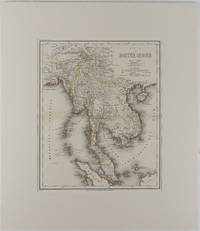
MEYER, HERRMANN JULIUS.
Map - Malay Peninsula Karte von Hinter Indien
Hildburghausen: Bibliographischen Instituts. 1866. Engraved map with outline hand colour central fold 37 x 30 cm 47.4 x 36.2 cm sheet colour key to territorial control and administrative boundaries major cites towns roads rivers and mountains relief shown by hachures light toning in very good condition preserved in modern window mount. Detailed 19th Century regional map of the Malay Peninsula Vietnam Cambodia etc. extending from the Straits of Malaca and Singapore north to Hainan and the Gulf of Tonquin. Text in German prepared for Meyer's Hand Atlas noted in the marginal caption top-left . Bibliographischen Instituts unknown
Référence libraire : 175919
|
|
|
Meyer, Johann Ludwig von Knonau (1705?1785)
Weiningen bei Zürich.
o.J. Kol. Lithographie von T. Rey. Bildausschnitt: 19 x 22 cm. Rahmen: 33,5 x 35 cm. + Wichtig: Für unsere Kunden in der EU erfolgt der Versand alle 14 Tage verzollt ab Deutschland / Postbank-Konto in Deutschland vorhanden +, Abb.
Référence libraire : 696DG

|
|
|
Meysels, Theodor F., in collaboration with Lucian O. Meysels. Lay-out and cover by LF. Toby. Maps by Zvi Friedlaender L. F.
Israel in Your Pocket A Ramblers' Guide. Volume One: Northern Israel Second revised and enlarged Edition 1954 -with- Volume Two: Central Israel and Jerusalem's Old City Bethlehem & Jericho 1953 -with- Volume Three: Southern Israel
Jerusalem: Ben-Dor Israel Publishing Co. Ltd 1955. Paperback. Respectively 129 xxvi 127-280 xxiv 281-398 xxiv. Matching small softbounds in upright paper covers 6.5x3.5 inches diverse monochrome colors for each installment. Later issues were bound together in a singleton booklet. Our set a second printing and two firsts are edgeworn with faint abrasion to outer joints. These volumes are quite sound but the text paper is acidic toned and beginning to get fragile. We detect a line of penciling to terminal leaf of v.I else good copies of this complete set all in about the same shape. Ben-Dor Israel Publishing Co. Ltd paperback
Référence libraire : 312611

|
|
|
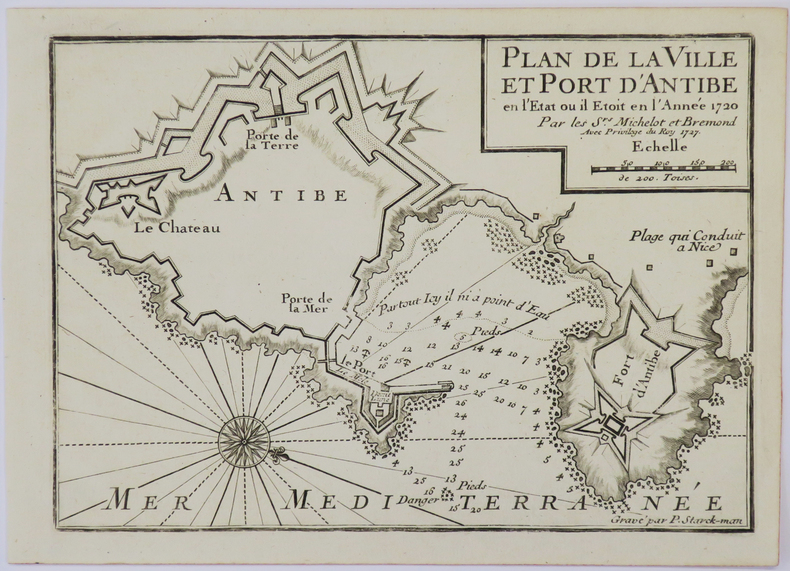
MICHELOT (Henri) & BREMOND (Laurent).
[ANTIBES] Plan de la ville et port d'Antibe en l'état où il étoit en l'année 1720.
1727. 177 x 250 mm.
Référence libraire : LBW-4932
|
|
|
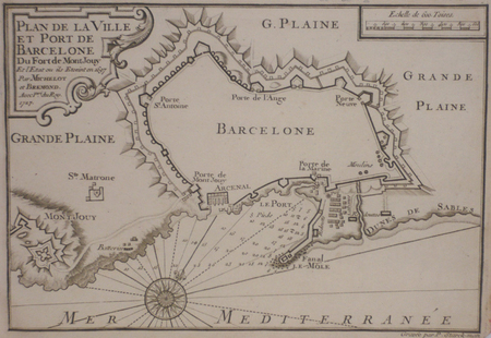
MICHELOT & BREMOND;
[BARCELONE] Plan de la ville et port de Barcelone du fort de Mont Jouy.
1727 174 x 254 mm.
Référence libraire : LBW024f1
|
|
|
MICHELOT & BREMOND;
[CATALOGNE/ROSES] Plan de la baye et citadelle de Rose et de Tourrille.
1727 172 x 251 mm.
Référence libraire : LBW024f2
|
|
|
MICHELOT & BREMOND;
[CATALOGNE/CADAQUES] Plan du port de Cadequié en Catalogne.
1727 173 x 251 mm.
Référence libraire : LBW024f3
|
|
|
MICHELOT & BREMOND;
[ELBE] Plan de Porto Ferraro en l'isle de l'Elbe.
1730 178 x 255 mm.
Référence libraire : LBW002a2
|
|
|
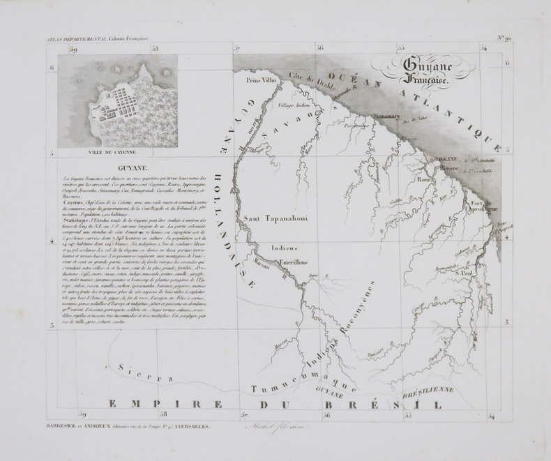
MICHEL.
[GUYANE] Guyane Française.
Versailles, Barreswil et Andrieux, 1840. 192 x 230 mm.
Référence libraire : LBW-4797
|
|
|
MICHELOT & BREMOND;
[MESSINE] Partie de la ville et port de Messine.
1727 173 x 250 mm.
Référence libraire : LBW00265
|
|
|
MICHELOT & BREMOND;
[NAPLES] Plan du golfe de Naples.
1727 174 x 250 mm.
Référence libraire : LBW0026c

|
|
|
MICHELOT & BRÉMOND.
[PALERME] Plan de la ville, port et rades de Palerme.
[1730]. 175 x 250 mm.
Référence libraire : LBW00268
|
|
|
MICHEL-LÉVY (Auguste) & JACQUOT (André-Eugène).
[THONON-les-BAINS/GÉOLOGIE] Carte topographique de l'État-Major. Carte géologique détaillée. Thonon (Pontarlier). Feuille n°150.
Paris, Ch. Béranger, Août 1894. En 24 sections montées sur toile et repliées, formant une carte de 0,62 x 1,16 m ; étiquette au dos de l'éditeur Charles Béranger.
Référence libraire : LBW-8466

|
|
|
Michelin
Bretagne (Michelin Green Guides)
Michelin Editions des Voyages 2006 453 pages 11 8x2x23 2cm. 2006. Broché. 453 pages.
Référence libraire : 500161557

|
|
|
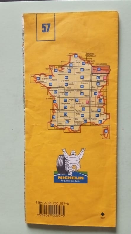
MICHELIN
Carte Michelin n° 76 "AURILLAC / SAINT ETIENNE"
Une carte routière au 1/ 200 000e, publiée en 1985, bon état
Référence libraire : LFA-126726783
|
|
|
MICHELIN (carte)
Carte Michelin du théâtre de la Guerre, Nord-Est
Clermont-Ferrand, Michelin, s.d., 56 X 65 cm, dépl., imp. coul. Échelle 1 : 1000000e
Référence libraire : 3716
|
|
|
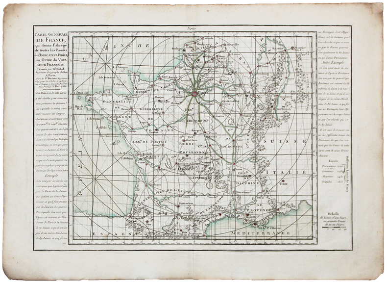
MICHEL (Claude-Sidoine).
Carte générale de France.
Paris, Sr. Desnos, 1766 [1767]. 231 x 328 mm.
Référence libraire : LBW-5363
|
|
|
MICCINI Eugenio
Caro Oggetto Videoteche 1979
Firenze Florence La Piramide 1979 In-12 En feuilles couverture à rabat Edition originale
Référence libraire : 006046
|
|
|
Michel Deguy
Donnant donnant : cartes airs brevets
Gallimard 1981 139 pages in8. 1981. broché. 139 pages. Ce livre est un recueil anthologique qui regroupe tous les poèmes de Michel Deguy publiés entre 1960 et 1980 remplaçant deux volumes précédents. Les textes empreints d'une rigueur formelle explorent des thèmes comme l'exil la nostalgie des origines et un questionnement profond sur la nature et la destination de la poésie
Référence libraire : 6165

|
|
|
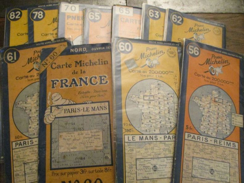
Michelin
ensemble de 15 carte Michelin au 1/200000 années 1930/40 1 cm pour 2 Km bon état publicités Michelin au verso
1515 1 - Anvers-Rotterdam51 - Boulogne-Lille53 - Arras-Mézières55 - Caen-Paris56 - Paris-Reims62 - Chaumont-Strasbourg64 - Anger-Orléans65 - Auxerre-Dijon66 - Dijon-Mulhouse70 - Beaune-évian74 - Lyon-Genève75 - Bordeaux-Tulle84 - Marseille-Menton89 - Paris sud93 - Lyon-Avignon
Référence libraire : 6298

|
|
|
Michelin
ensemble de 11 cartes Michelin années 30/50 au 200 000 1 cm pour 2Kmbon état publicités michelin au verso
56 - Paris-Reims60 - Paris le mans (sur toile)60 - Le Mans Paris61 - Paris-Chaumont62 - Chaumont-Strasbourg63 - Vannes-Angers65 - Auxerre-Dijon65 - Auxerre-Dijon (sur toile)70 - Beaune-evian78 - Bordeaux-Biarritz82 - Pau-Toulouse
Référence libraire : 6299
|
|
|
Michelin Travel Publications
Epinal-Nancy-Strasbourg (Michelin Maps)
Michelin Maps 1997 10 6x0 4x24 6cm. 1997. map.
Référence libraire : 500179373

|
|
|
Michelin
Guide Vert - ROME WEEK-END (GUIDES VERTS/GROEN MICHELIN)
Michelin Benelux 2010 143 pages 12x1 6x15 8cm. 2010. Broché. 143 pages.
Référence libraire : 8469 ISBN : 2067145258

|
|
|
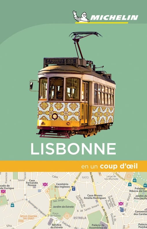
Michelin
LISBONNE EN UN COUP D'OEIL
Michelin 2018 1 pages 10 67x15 75x1 27cm. 2018. Broché. 1 pages.
Référence libraire : 500048582
|
|
|
MICHAUD Jean-Luc Cartes de l'AUREG et photographies.
Manifeste pour le littoral.
Référence libraire : 205360

|
|
|
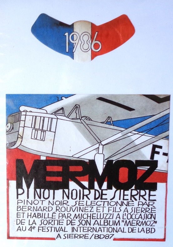
Micheluzzi:
Mermoz. Pinot noir de Sierre.
Etiquette de vin et bandeau, pinot noir sélectionné par Bernard Rouvinez.
Référence libraire : 1900
|
|
|
Michelin Travel Publications Pneu Michelin
Michelin Karten Bl.517 : Bretagne (Michelin Maps)
Travel House Media 2003 11x1x24 6cm. 2003. map.
Référence libraire : 500085871

|
|
|
MICHELIN
Michelin Le Guide Vert Languedoc (MICHELIN Grüne Reiseführer)
Michelin Vertrieb durch GRÄFE UND UNZER VERLAG GmbH 2013 459 pages 11 6x2 6x21 8cm. 2013. Broché. 459 pages.
Référence libraire : 500161555

|
|
|
Michelin Travel Publications
Michelin Le Guide Vert Chateaux De LA Loire: Edition 2000 (Michelin Green Guide)
Michelin 2000 390 pages 11 8x1 2x23 2cm. 2000. Broché. 390 pages.
Référence libraire : 500292731

|
|
|
Michelin Travel Publications
Michelin No. 84 Marseille-Toulon-Nice Menton 1:200 000. (Michelin Maps)
Travel House Media 2000 10 6x0 4x24 2cm. 2000. map.
Référence libraire : 500298212

|
|
|
Michelin Travel Publications
Montargis-Auxerre-Dijon (Michelin Maps)
Michelin Maps 1997 11x0x25cm. 1997. map.
Référence libraire : 500179374

|
|
|
Michelin cartes et guides
Nord Pas-de-Calais
Michelin 2015 2015.
Référence libraire : 500136704

|
|
|
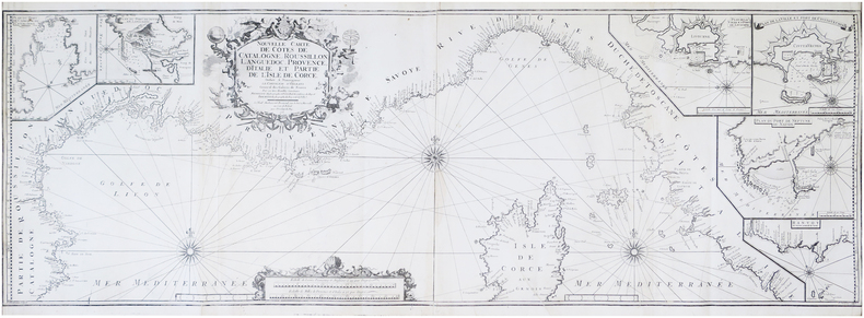
MICHELOT (Henri) & BRÉMOND (Laurent).
Nouvelle carte de côtes de Catalogne, Roussillon, Languedoc, Provence, d'Italie, et partie de l'isle de Corce.
Marseille, Laurent Brémond, 1718. En deux feuilles jointes formant une carte de 46,5 x 136,5 cm.
Référence libraire : LBW-7946
|
|
|
Michelin Clermont-Ferrand Michelin & Cie éditeur coll. Guides illustrés Michelin des champs de bataille 1914-1918 1919 - Agrafé 14 cm x 22 cm 64 pages - Texte de Michelin - Photos N&B in et hors-texte + plans et cartes - Ouvrage publié A la mémoire des ouvriers et employés des usines Michelin morts glorieusement pour la Patrie. - Bon état
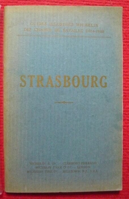
Strasbourg (Guides illustrés Michelin)
1919. Clermont-Ferrand Michelin & Cie éditeur coll. Guides illustrés Michelin des champs de bataille 1914-1918 1919 - Agrafé 14 cm x 22 cm 64 pages - Texte de Michelin - Photos N&B in et hors-texte + plans et cartes - Ouvrage publié A la mémoire des ouvriers et employés des usines Michelin morts glorieusement pour la Patrie. - Bon état
Référence libraire : 9798
|
|
|
Michelin Travel Publications
Vannes la Baule Angers (Michelin Maps)
Travel House Media 2001 24 4x0 8x10 6cm. 2001. map.
Référence libraire : 500085864

|
|
|
Michelin Travel Publications
Verdun-Metz-Wissembourg (Michelin Maps)
Michelin Maps 1997 10 6x0 6x24 6cm. 1997. Broché.
Référence libraire : 500179375
|
|
|
Michael Sagner; Garry Egger MPH PhD MAPS; Andrew Binns; Stephan Rossner
Lifestyle Medicine: Lifestyle the Environment and Preventive Medicine in Health and Disease
new. unknown
Référence libraire : 29134098-n ISBN : 0128104015 9780128104019

|
|
|
Michael Sagner; Garry Egger MPH PhD MAPS; Andrew Binns; Stephan Rossner
Lifestyle Medicine: Lifestyle the Environment and Preventive Medicine in Health and Disease
like new. unknown
Référence libraire : 29134098 ISBN : 0128104015 9780128104019
|
|
|
Michael Sagner [Editor]; Garry Egger MPH PhD MAPS [Editor]; Andrew Binns [Editor]; Stephan Rossner [Editor];
Lifestyle Medicine: Lifestyle the Environment and Preventive Medicine in Health and Disease
Academic Press 2017-04-20. paperback. New. 6x0x9. New Textbook Ships with Tracking Academic Press paperback
Référence libraire : SKU0620141 ISBN : 0128104015 9780128104019
|
|
|
Michael Sagner [Editor]; Garry Egger MPH PhD MAPS [Editor]; Andrew Binns [Editor]; Stephan Rossner [Editor];
Lifestyle Medicine: Lifestyle the Environment and Preventive Medicine in Health and Disease
Academic Press 2017-04-20. Paperback. Good. Textbook May Have Highlights Notes and/or Underlining BOOK ONLYNO ACCESS CODE NO CD Ships with Emailed Tracking Academic Press paperback
Référence libraire : SKU0470112 ISBN : 0128104015 9780128104019
|
|
|
Michael Sagner; Garry Egger MPH PhD MAPS; Andrew Binns; Stephan Rossner
Lifestyle Medicine: Lifestyle the Environment and Preventive Medicine in Health and Disease
Academic Press. 3. Good. It's a preowned item in good condition and includes all the pages. It may have some general signs of wear and tear such as markings highlighting slight damage to the cover minimal wear to the binding etc. but they will not affect the overall reading experience. Academic Press unknown
Référence libraire : 0128104015-11-1 ISBN : 0128104015 9780128104019
|
|
|
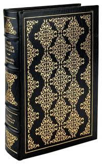
Michael Shaara; Don Pitcher [maps]
The Killer Angels Limited Edition
Franklin Center PA: Franklin Library 1979. Fine. Franklin Center PA: Franklin Library 1979. First Franklin Library Edition Limited to an unspecified number of copies. Octavo; publisher's full blue gilt-tooled goat spine in five compartments all edges gilt blue moiré silk endpapers; xxi7410pp.; illus. throughout. Fine condition. Franklin Library unknown
Référence libraire : 45370
|
|
|
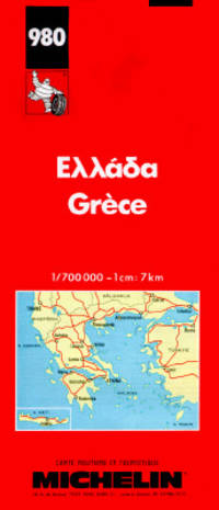
Michelin
Ellada/ Grece /Greece/ Greichenland 980
Paris: Michelin Travel Pubns 1989 Map. Fine. Soft cover. Fold out large scale map of Greece Scale 1: 700000 Place names in Greek with Roman alphabet transliteration. Legends in Greek FrenchEnglish and German This map is still useful in general terms but note the date it does NOT.therefore include the new highways. Michelin Travel Pubns paperback
Référence libraire : 36405 ISBN : 206700980X 9782067009806
|
|
|
Michelin
Ellada/ Grece /Greece/ Greichenland [980]
Fold out large scale map of Greece (Scale 1: 700,000) Place names in Greek with Roman alphabet transliteration. Legends in Greek, French,English and German ,This map is still useful in general terms, but note the date, it does NOT.therefore, include the new highways Map
|
|
 Recevoir par e-mail
 Télécharger en PDF
 Flux RSS


