|
GENERALSTABEN (UDG.).
Generalstabens topographiske Kort over Danmark. (Sjælland, Møen og nogle Smaaøer i 15 kortblade). 1:80.000.
Kjøbenhavn, Generalstaben, 1847-64. Omfattende samling af kobberstukne kortblade, hvert blad måler 43x52 cm. Foldet og opbevaret i en samtidig shirtkassette. Alle blade foldet og monteret med lærred på bagsiden og opdelt i felter. Kortbladene er kobberstukket og alle illuminerede (kobberfarvetryk). I fin stand.
Référence libraire : 53378
|
|
|
RINGGOLD, CADWALADER.
A Series of Charts with Sailing Directions, Embracing Surveys of the Farallones, entrance to the bay of San Francisco, bays of San Francisco and San Pablo, straits of Carquines and Suisun Bay, confluence and deltic branches of the Sacramento and San J... - [THE MOST ACCURATE CHARTS UP UNTIL THAT TIME OF THE SAN FRANCISCO BAY AREA]
Washington, Jno. T. Towers, 1851. 4to. In publishers original full pictoral green cloth. Front and back board with embossed title and ornamentation, showing an eagle holding a banner and anchor beneath whom Columbia sits holding the shield of California with a bear asleep at her feet. Front board in gold. Lower front board with gilt stamp. Stamp to front free end-paper and title-page. Light wear to extremities and internally with light occassional miscolouring. 44. pp. + 11 lithographic plates including frontispiece and 6 folding maps.
Référence libraire : 53713

|
|
|
"DANMARK - ORTELIUS, ABRAHAM.
Daniae Regni Typus.
(Antwerpen ca. 1580). 32 x 41 cm. Kobberstukket Danmarkskort i original håndkolorereing. Med Skåne, Halland og Blekinge samt den nordlige del af Tyskland.Foldningen fint forstærket på bagsiden med japanpapir.
Référence libraire : 54214
|
|
|
KÖLN - T.F. THIRIAT.
Grundriss der Stadt Köln.
1815. (ca. 55 x 94 cm.). Large engraved plan of Köln. Gezeichnet und gestochen von Picquet. Right margins with a few closed tears. A bit of fraying outside image. With 2 engraved attached flaps (fortifications) and with street-indexes.
Référence libraire : 54701
|
|
|
METZ - JEAN-CLAUDE DEZAUCHE.
Nouveau Plan de la Ville de Metz. Avec tous le Changements et Augmentations faites jusq'uen 1784. Par M. De.... (Dezauche).
Paris, Dezauche, (1784). (58 x 87 cm.). Engraved map of Metz. A few small closed marginal tears to paper, not reaching image. A tear to lower part (3 cm) repaired on verso, no loss of image.
Référence libraire : 54704
|
|
|
"LILLE - RUDEMARE.
Plan de la Ville et Citadelle de Lille, suivant les nouveaux Changements, revu et corrigé par Rudemare.
Paris, Jean, 1820. (55 x 76 cm.). Engraved plan of Lille with explanatory text on both sides. At bottom inserted ""Vue de Lille du costé de la Porte de Paris"".
Référence libraire : 54705
|
|
|
IRELAND - ALEXANDER TAYLOR.
A New Map of Ireland having the Great Features of the Country described in a Manner highly expressive, and the Distances between the Towns and stages marked in Miles and Furlongs for the Use of Travellers.
London, W. Faden, 1793. (75 x 62 cm.). Engraved map of Ireland for travelling use, sectioned and laid down on linen. With 2 large fine engraved cartouches and handcoloured in outline.
Référence libraire : 55054
|
|
|
"ODENSE - BRAUN & HOGENBERG.
Civitatis Episcopalis Othenarum sive Otthoniæ, ut vulgo dicitur Fioniae Insularum Daniæ Regni.
(Köln, 1593). Kobberstukket prospekt over Odense visende byen i fugleperspektiv. 32,5 x 47,5 cm. Prospektet er i fin stand og i samtidig håndkolorering og indrammet under glas i en smuk ældre guldramme (49 x 62 cm.).
Référence libraire : 55185
|
|
|
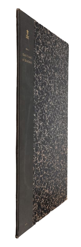
SEACHART SCOTLAND - JOHN MARR, JOHN THORNTON.
A New Description of the East Coast of Scotland from Berwick to Bokannais: Wherein is fully shewed the Chief Forelands, Bays, Roads, Rivers, Havens, Creeks, Sands, Shoals, Depths of Water and Anchoridg, with the Course of the Tides, and what Moon make...
(London, ca. 1810). Folio. (45 x 28 cm.). Later hcloth. Gilt lettering on upper cover. 4 pp. in folio. + engraved map (44 x 52 cm.) Chart of the East Coast of Scotland Bu John Thornton. Left and right margins shaved (no loss of image). Light browning and a few brownspots.
Référence libraire : 55309
|
|
|
MAP - ARCTIC REGIONS.
Geological Map of the Arctic. Prepared by the First International Symposium on Arctic Geology sponsored by the Alberta Society of Petroleum Geologists.
Calgarry - Alberta Canada, Symposium Committee, 1960. (102 x 115 cm.). Large colourprinted circular map of the Arctic Regions. Folded. Well-preserved.
Référence libraire : 55325
|
|
|
NORD-POL KARTE - NORTH POLE MAP.
Neueste Handkarte der Gebiete um den Nordpol. Breiten- Massstab 1:20 000 000. Nach zuverlässige Quellen bearbeitet von A. Herrich.
Glogau, Carl Flemming (ca. 1900). Orig. printed clothbacked boards. Map in colour (42 x 48 cm.) inserted and folded.
Référence libraire : 55490
|
|
|
MAP - AUSTRALIA - STÜLPNAGEL, F. v.
Festland von Australien und benachbarte Inseln.
(Gotha, Justus Perthes), 1841. Engraved map (35,5 x 43,5 cm.). Handcoloured in outline. Fine and clean.
Référence libraire : 55741
|
|
|
MAP - AMERICA - ADOLF STIELER.
Der nordöstliche Theil der Vereinigten Staaten von Nord America Neue Bearbeitung von Ad.St. 1831.
(Gotha, Justus Perthes), 1831. Engraved map (34,5 x 43 cm.). Handcoloured in outline. Gestochen von Joh. Carl Ausfeld.
Référence libraire : 55743
|
|
|
MAP - IRAN und TURAN - STÜLPNAGEL, F. v.
Iran und Turan (Persien, Afghanistan, Beludschistan, Turkestan). Neue Bearbeitung von F. v. Stülpnagel.
(Gotha, Justus Perthes), 1843. Engraved map (35,5 x 44 cm.). Handcoloured in outline.
Référence libraire : 55747
|
|
|
MAP - GIBRALTAR.
Plan der Berühmten Vestung Gibraltar belagert von den Spaniern und Frantzosen seit Anno 1779.
(Frankfurt am M., um 1780). (36 x 26 cm.) Engraved handcoloured map/plan of Gibraltar with text and with insets of Southern Span and North Africa around Ceuta and Tanger. A stamp in upper left corner. I.M. Zell, sculp. (Johann Michael Zell)Some brownspots.
Référence libraire : 55916
|
|
|
MAP - GIBRALTAR.
Nueba Vista Gibraltar. 1782.
Wien, L. Hochenleiter, um 1782. (22 x 37 cm.). Engraved map (bird-eye-view) with ships in the sea, fortification and bombardment. Text in Spanish. Mildly brownspotted.
Référence libraire : 55917
|
|
|
CADIX -
Plan de la Ville de Cadix. Sa Baie, et ses Environs. Rédigé d'apres une Carte trés exacte et particulière
Milano, Chez Bettalli, (ca. 1810). (56 x 84 cm.). Large engraved plan of Cadix and surroundings, sectioned in 8 and mounted on linen. Handcoloured. Gravé en Milan par Louis Rados. Some faint scattered brownspots.
Référence libraire : 56906
|
|
|
(LÖWENÖRN, P. (POUL) de). - SHETLAND ISLANDS.
Beretning om et forbedret Kaart over de Hetlandske Öer, tilligemed trende Blade med Landtoninger og et speciel Kaart over Valley-Sund paa Hetland. Udgivet fra det Kongelige Söe-Kaarte-Archiv 1787. (Description of a new improved chart of the Islands of...
Kiöbenhavn, Thiele, 1787. 4to. Originale blåmarmorerede omslag. Stempel på titelbladet. 16 pp., 4 kobberstukne plancher (3 foldede med landtoninger samt et kort). Rent velbevaret eksemplar på skrivepapir.
Référence libraire : 56969
|
|
|
PURDY, JOHN.
The New Sailing Directory for the Coasts of Spain and Portugal, from Cape Finisterre to Cadiz, and Thence to the Eastward of Malaga: Composed to Accompany the Chart.
London, Laurie, 1839. 8vo. In contemporary blank wrappers with part of original printed wrapper pasted on. Stamp to front wrapper and title-page. Internally fine and clean. iv, 38 pp.
Référence libraire : 57123
|
|
|
WOLFE, JAMES.
Sailing Directions for the Lower Shannon and the Lough Derg.
London, Admiralty, 1843 8vo. In recent half cloth with gilt stamp and lettering to front board. Small paper label pasted on to verso front board and two stamps to title-page. Internally fine and clean. 32 pp.
Référence libraire : 57129
|
|
|
SØKORT - SØKORTARCHIVET (UDG.).
Store Belt (Samsøe Beltet). 1832. Rettet til 1848.
(København), KDSK (Kgl. Danske Søkort Archiv), 1848. Kobberstukket søkort (106 x 63 cm.). I original opsætning på lærred og monteret i 27 sektioner (9 x 3). Foldet og opbevaret i det originale marmorerede foderal. Ren og velbevaret.
Référence libraire : 57654
|
|
|
MAP - BRAZIL. - EDWARD STANFORD.
Brazil from official and other Sources prepared in the international Bureau of the American Republics, Williams C. Fox, Director.
London, Edward Stanford, 1905. (95 x 95,5 cm.). A large lithographed map of Brazil, lithographed in colours, original linen-backed and folded in 35 sections. Folded in the original cloth-case with the original printed title-label preserved. A fine copy.
Référence libraire : 57772
|
|
|
WESSEL, CASPAR. - ET HISTORISK KORT.
Den Nord=Østlige Fierdedeel af Siælland under det kongl: Videnskabernes Societets Direction ved rigtig Landmaaling optaget og ved trigonometriske samt astronomiske Operationer prövet. Reduceret og tegnet Aar 1768 af Caspar Wessel.
(København), 1771. (59 x 69 cm.). Kobberstukket kort over Nordøstsjælland. Opdelt i 24 sektioner og opsat på lærred således, at det ved foldning let kunne medbringes.
Référence libraire : 58005
|
|
|
WESSEL, CASPAR.
Den syd østlige Fierdedeel af Siælland under det Kongl: Videnskabernes Societets Direction ved rigtig Landmaaling optaget og ved trigonometriske samt astronomiske Operationer prövet. Tegnet af C. Wessel. Aar 1770.
(København, 1771). (59 x 69 cm.). Kobberstukket kort over Sydøstsjælland fra Køge Bugt til den nordlige del af Møn. Opdelt i 24 sektioner og opsat på lærred således, at det ved foldning let kunne medbringes. Enkelte svage brunpletter.
Référence libraire : 58006
|
|
|
"(FREEDEN, W. VON.)
On the Routes of Mail Steamers between the English Channel and New York.
(Washington : Government printing Office, 1873). 8vo. In later half cloth with the original wrappers pasted on to boards. From ""Mittheilungen aus der norddeutschen Seewarte"", von W. von Freeden. Abstract, translated from the ""Revue maritime et coloniale"". July, 1873. Stamp to front board and first leaf of text. 12 pp. + folded chart.
Référence libraire : 58308
|
|
|
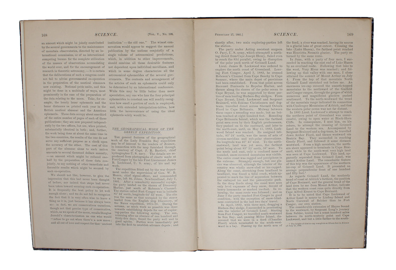
"GREELY, A. W. (+) FRANZ BOAS.
The Geographical Work of the Greely Expedition [Greely] (+) The Configuration of Grinnell Land and Ellesmere Land [Boas] (+) [Large folded map:] North America polar regions : Baffin Bay to Lincoln Sea, showing the most recent discoveries including tho... - [FIRST ACCOUNT OF THE LADY FRANKLIN BAY EXPEDITION]
(New York, 1885). 4to. In later half cloth with gilt lettering and stamp to front board. In ""Science"", Vol. 5, No. 108, Feb. 27. Paper label pasted on to front board. The two titles underlined in blue pencil. Stamp to verso of map and almost parted in two, long tear in foldings, otherwise internally fine and clean. Pp. iii-iv, 163-185 + large folded map: ""North America polar regions : Baffin Bay to Lincoln Sea, showing the most recent discoveries including those of U.S.S. Polaris Expedition in 1871-2, under Captain C.F. Hall, British Arctic Expedition in 1875-6, under Captain G.S. Nares, R.N., The Lady Franklin Bay Expedition in 1881-4, under Lieutenant A.W. Greely, U.S.A""
Référence libraire : 58309
|
|
|
"BRUUN, DANIEL.
Generalstabens Opmaaling paa Island.
København, Det Schubotheske Forlag, 1905. 8vo. In contemporary board with the original printed front wrapper pasted on to front board. Stamp to front board and verso of front board. A fine copy. 20 pp + 3 coloured maps (of which one if folded).
Référence libraire : 58605

|
|
|
BEAURAIN, JEAN de.
(Feldzüge des Marschalls von Luxemburg, oder Militärgeschichte von Flandern in den Jahren 1690-1694). Nur die 4 Kartentheile.
(Potsdam, 1783-85). 4to. (36 x 29 cm.). 4 portfolios in hcalf with ties. Gilt titlelabels on upper boards. Containing maps to all 4 campaigns. 64 (of 70 ?) folded maps in folio, partly handcoloured. Occasionally faint scattered brownspots, but generally clean.
Référence libraire : 58667
|
|
|
BEAURAIN, JEAN de.
(Feldzüge des Marschalls von Luxemburg, oder Militärgeschichte von Flandern in den Jahren 1690-1694). Nur die 4 Kartentheile.
(Potsdam, 1783-85). 4to. (36 x 29 cm.). 4 portfolios in hcalf with ties. Gilt titlelabels on upper boards. Containing maps to all 4 campaigns. 64 (of 70 ?) folded maps in folio, partly handcoloured. Occasionally faint scattered brownspots, but generally clean.
Référence libraire : 58727
|
|
|
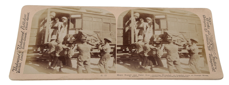
STEROSCOPE CARDS -
South African War through the Stereoscope. Vol. I-II.
Washington, Underwood & Underwood, 1900 - 1901. 72 stereoscope card (177 x 90 mm) housed in the original book-like slipcase. Slipcase with wear. Cards fine and clean.
Référence libraire : 59848
|
|
|
EUGÈNE-HENRI FRICX
Table des cartes des Pays Bas et des frontieres de France, avec un recueil des plans des villes, siéges et batailles données entre les hauts allies et la France. - [ONE OF THE MOST IMPORTANT MAP PUBLISHERS IN THE SOUTHERN NETHERLANDS]
Brussels, 1712. Folio (512 x 315 mm). In contemporary half calf with seven raised bands. Spine and hindges with wear. Leather brittle and upper and lower 10 cm hindges detached. Two library labels pasted on to pasted down front end-paper. Upper margin of first three leaves blind-stamped. Handwritten (19th century hand) index mounted in on verso of first map and each map numbered. With 75 maps and plans, many double-page or folding: 24 cartes des Pays Bas, Carte générale de Brabant, Carte du Pays de Waes, Carte des Postes d'Allemagne, 48 plans des Villes, Sièges & Batailles (complete). 3 maps with minor marginal tear (outside plate), 2 with minor split to lower part of middle folding. A few maps at end with browning. A few plates (primarily 61, 50, 33, 25) heavily trimmed with slight loss to upper margin. An overall fine and clean copy.
Référence libraire : 60165

|
|
|
OUDIETTE (Charles)
Dictionnaire topographique des environs de Paris.
1817 À Paris, chez l’Auteur, 1817.
Référence libraire : 446

|
|
|
CHAMOT
Plan de Paris divisé en 12 Mairies subdivisée chacune en 4 Parties.
1802 Paris, Chez Jean Goujon, 1802.
Référence libraire : 585

|
|
|
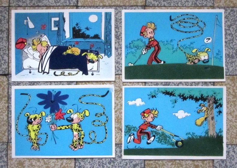
Franquin:
12 cartes feutrine - Spirou et Fantasio, Marsulpilami, Gaston Lagaffe.
Anvers Flock-Indus, 1960. Série complète de 12 cartes réalisées avec un système de flocage breveté par l'éditeur, qui permettait de recouvrir une partie du dessin par de la feutrine. Les cartes sont vierges et en parfaite condition.
Référence libraire : 82
|
|
|
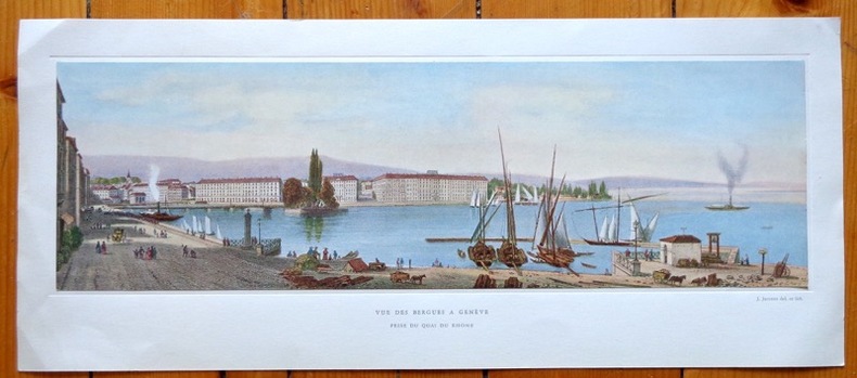
Jaccottet
Vue des Bergues à Genève, prise du quai du Rhône
Jolie reproduction d'une vue de Genève au format 42 x 18 cm (feuille), légendée, contrecollée dans une cuvette. Légères traces de pli aux coins.
Référence libraire : 641
|
|
|
Disney Walt:
Mickey Mouse - petite sérigraphie.
Christian Desbois, 1999. Rare petite sérigraphie au format 15 x 22, avec sa serpente muette. A l'état de neuf.
Référence libraire : 828

|
|
|
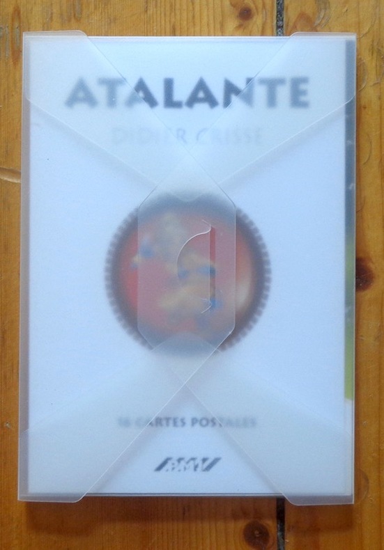
Crisse Didier:
Atalante. 16 cartes postales.
PMJ éditions Port-folio translucide, bien complet des 16 cartes postales annoncées au feuillet de titre. A l'état de neuf.
Référence libraire : 911
|
|
|
Got Yves:
Petite sérigraphie.
Petite sérigraphie coquine, format carte postale. A l'état de neuf.
Référence libraire : 968

|
|
|
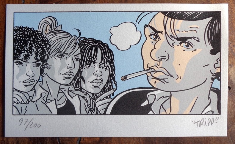
Tripp:
Petite sérigaphie couleurs.
2012 Sérigraphie au format 20 x 12.
Référence libraire : 984
|
|
|
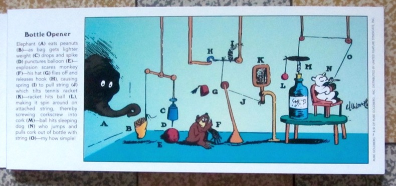
Goldberg Rube:
Inventions! 30 Rube Goldberg Postcards.
Stewart, Tabori & Chang, 1996. 30 cartes postales d'inventions loufoques et hilarantes par Rube Goldberg. Trace d'étiquette de prix au second plat, pour le reste à l'état de neuf.
Référence libraire : 1278
|
|
|
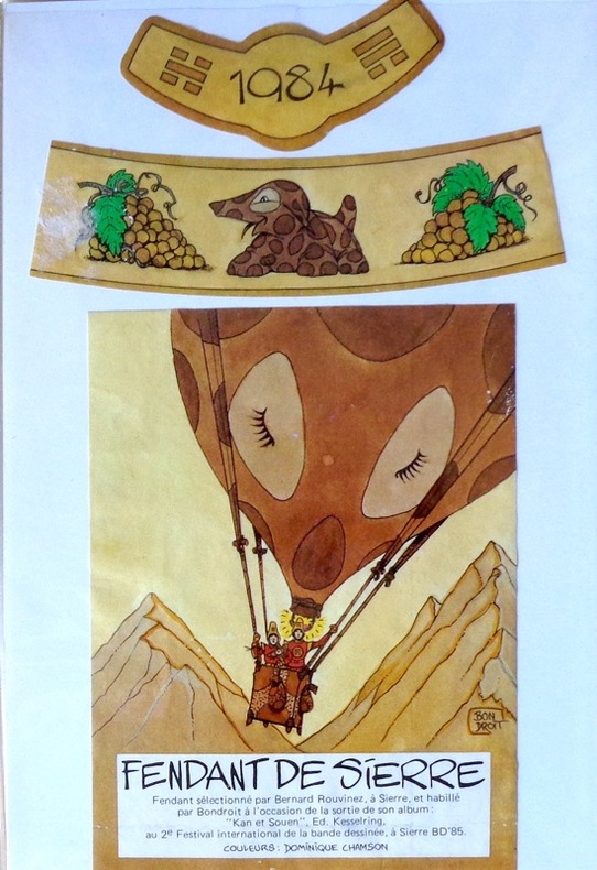
Bondroit:
Etiquette Fendant de Sierre.
Etiquette de vin 12 x 9 cm. et 2 bandeaux pour un Fendant de Sierre (Bernard Rouvinez).
Référence libraire : 1897
|
|
|
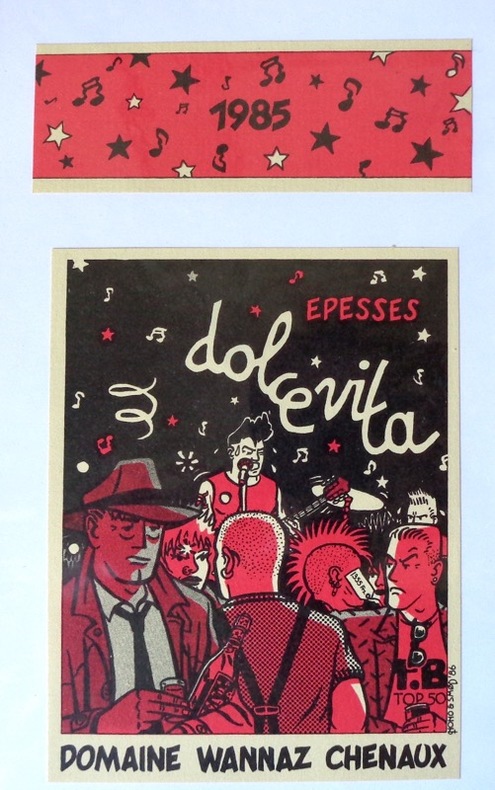
Nono & Smod:
Dolce vita, étiquette de vin.
Etiquette de vin et bandeau pour un Epesse du domaine Wannaz à Chenaux.
Référence libraire : 1898
|
|
|
Barrigue:
Etiquette Dôle de Sierre 1982.
Etiquette et bandeau pour une Dôle de Sierre Tavelli.
Référence libraire : 1899

|
|
|
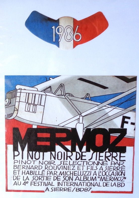
Micheluzzi:
Mermoz. Pinot noir de Sierre.
Etiquette de vin et bandeau, pinot noir sélectionné par Bernard Rouvinez.
Référence libraire : 1900
|
|
|
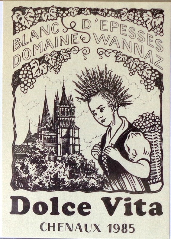
Witzig Roland:
Dolce Vita - étiquette de vin.
Etiquette pour un blanc d'Epesses, domaine Wannaz à Chenaux, 1985.
Référence libraire : 1901
|
|
|
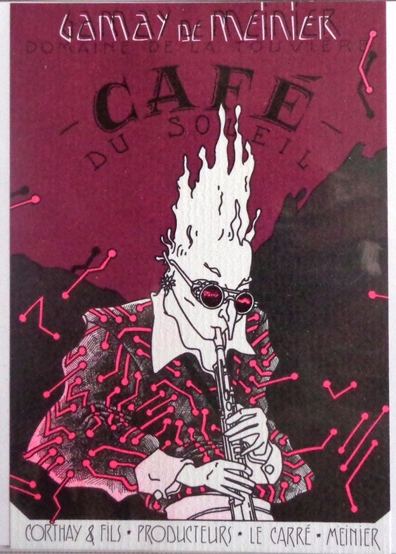
Simon:
Etiquette de vin Café du Soleil.
Référence libraire : 1903
|
|
|
Bilal Enki:
Transit - Cartes de transit.
Paris Galerie Escale, (1990) Ensemble de 4 cartes de transit (Irina, Mamadi, Farida, Yoko) + une carte à remplir, que l'on pouvait à l'époque renvoyer avec une photo, une mèche de cheveux et l'empreinte du majeur pour obtenir sa carte personnalisée. Sous pochette pergamine imprimée en rouge.
Référence libraire : 1913

|
|
|
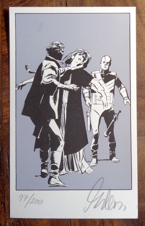
Gillon:
Petite sérigraphie.
Petite sérigraphie au format 12 x 20, tirage limité à 200 exemplaires numérotés, signés par l'artiste. Tampon de la Marge au dos. A l'état de neuf.
Référence libraire : 2002
|
|
|
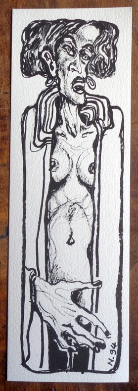
Nicollet Jean-Michel:
Petite sérigraphie en noir.
1994. Sérigraphie au format 7 x 22 cm., à l'état de neuf. Non signée.
Référence libraire : 2004
|
|
|
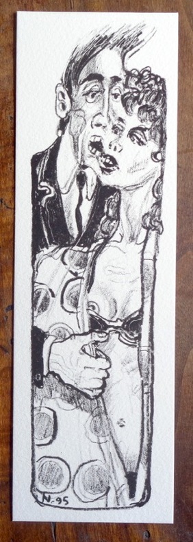
Nicollet Jean-Michel:
Petite sérigraphie en noir.
1995. Sérigraphie au format 7 x 22 cm., à l'état de neuf. Non signée.
Référence libraire : 2005
|
|
 Recevoir par e-mail
 Télécharger en PDF
 Flux RSS


