|
Del Rio Marcela
Perfil del Teatro de la Revolucià n Mexicana American University Studies Spanish Edition
Very Good. Used book in very good condition. Some cover wear may contain a few marks. 100% guaranteed. 041420 unknown
Référence libraire : 0820419923[vg] ISBN : 0820419923 9780820419923
|
|
|
Rio Cisneros Agustin del
Viraje pol�tico espa�ol durante la II Guerra Mundial 1943-1945 y r�plica al cerco internacional. 1945-1946.
Ed. del Movimiento 1965. 1965. Soft cover. paperback 8vo 609pp text in Spanish contents clean and tight no inscriptions covers rubbed Good condition. . Ed. del Movimiento, 1965, paperback
Référence libraire : 133967
|
|
|
Marita Martinez del Rio de Redo
Las perlas grises del mar de Cort�s.
M�xico Desconocido 2005. 2005. Soft cover. 9789685756228 Signed by Authors Spanish text paperback 8vo 142pp signed by the author inscribed to John Julius Norwich text clean and tight Very Good condition. ISBN: 9789685756228 . M�xico Desconocido, 2005. paperback
Référence libraire : 133930 ISBN : 9685756228 9789685756228
|
|
|
Anne Riviere
Camille Claudel: Catalogue Raisonne French Edition
Adam Biro January 1996. Hardcover. Used - Very Good. OP. DJ wrapped in protective cover. Except for slight staining along open edge of pages interior pages in very nice condition. Adam Biro hardcover
Référence libraire : 80501 ISBN : 2876601761 9782876601765
|
|
|
Anne Riviere
Camille Claudel: Catalogue Raisonne French Edition
Adam Biro January 1996. Hardcover. Used - Very Good. Very nice clean tight copy free of any marks. Wrapped in complimentary Brodart dust jacket protector. Adam Biro hardcover
Référence libraire : 42251 ISBN : 2876601761 9782876601765
|
|
|
Freud Sigmund translated by Joan Riviere
Civilization and Its Discontents
Hogarth Press London 1949 4th impression. /Dust Jacket Included. 1949. Hardcover. hardback 8vo 144pp owner's name on endpaper slight foxing text otherwise clean and tight publisher's green cloth gilt Very Good / Good dustwrapper ; wrapper spine and edges faded . Hogarth Press, London, 1949, 4th impression, hardcover
Référence libraire : 210235
|
|
|
Freud Sigmund translated by Joan Riviere
Civilization and Its Discontents
The Hogarth Press and the Institute of Psycho-Analysis 1946 Third Edition No 17 in the International Psycho-Analytical Library. Very Good/Dust Jacket Included. 1946. Hardcover. hardback 8vo 144pp owner's name on endpaper pages browned text otherwise clean and tight publisher's green cloth gilt Very Good / Good dustwrapper ; wrapper slightly frayed at corners and spine ends . The Hogarth Press and the Institute of Psycho-Analysis, 1946, Third Edition, No 17 in the International Psycho-Analytical Librar hardcover
Référence libraire : 450570
|
|
|
Sartorius Carl Christian; Johann Moritz Rugendas; Marita Martinez del Rio de Redo
Mexico y los mexicanos
San Angel Mexico San Angel Mexico 1973. Limited edition facsimile reprint. 1973. Hardcover. hardback large elephant folio 62pp 17 plates signed by the editor with gift inscription to John Julius Norwich and his name embossed on front cover contents clean and sound brown cloth board corners bumped Good condition . San Angel, Mexico, San Angel, Mexico, 1973. Limited edition, facsimile reprint, hardcover
Référence libraire : 778305
|
|
|
Marita Martinez del Rio de Redo
El Transporte en la Historia de Mexico
Edition Des Artes De Mexico Invierno 1972. . 1972. Hardcover. hardback large 4to 96pp numerous illustrations signed by the editor with gift inscription to John Julius Norwich and his bookplate on endpaper contents clean and sound brown cloth slightly marked Very Good / no dustwrapper . Edition Des Artes De Mexico Invierno, 1972. , hardcover
Référence libraire : 778308
|
|
|
Sol River
River: Plays Two Oberon Modern Playwrights v. 2
Oberon Books 2008-09-01. Paperback. Good. Oberon Books paperback
Référence libraire : SONG1840022663 ISBN : 1840022663 9781840022667
|
|
|
James River.
JAMES RIVER PRESENTS THE COLORS AND TEXTURES OF RETREEVE RECYCLED PAPERS
Southhampton PA: James River n.d. stiff paper wrappers. Paper Specimens. 12mo. stiff paper wrappers. 2 pages of text followed by five specimens printed in color. Paper specimen booklet issued by one of the premier paper companies in America. Printed in color throughout. James River) unknown
Référence libraire : 107322

|
|
|
Lowbury Edward & Press John & Riviere Michael
Troika
King's Lynn: Daedalus Press. Very Good. 1977. Limited Edition. Booklet. Clean and tightly bound paperback booklet with unclipped dustjacket appears little used. Flyer for this book laid in. Limited edition of 30 signed copies; this is no. 9 and is signed by all three authors ; Signed by All Authors . Daedalus Press unknown
Référence libraire : 30498

|
|
|
National Center for History in the Schools U. S.; Ankeney Kirk Editor; Del Rio Richard Editor; Nash Gary B. Editor; Vigilante
Bring History Alive: A Sourcebook for Teaching United States History
Natl Council for the Social 1996-12-01. Paperback. Very Good. In VERY GOOD Condition!! National Center for History: Bring History Alive! A Sourcebook for Teaching United States History Softcover Copyright-1997 ISBN:0963321854. We ship daily Mon-Sat. Customer service is always our top priority! Please contact us at 888-475-1077 to reach our customer service team!! Natl Council for the Social paperback
Référence libraire : 085302 ISBN : 0963321854 9780963321855
|
|
|
RIO GRANDE RIVER Jackson Hiestand Hook et al. illus.
Over the Rio Grande.
No date. Ca. 1890. Sepia--toned vignette illustrations unpaginated 12 pages folding accordian style 6 1/4 x 9 3/4 inches decorative iembossed gilt lettered cloth covered boards hardbound. Covers lightly rubbed. Very good condition. Attractive views found along the Rio Grande Railway. "Barkalow Bros." stamp on verso if last page. . hardcover
Référence libraire : 48168

|
|
|
OREGON HOOD RIVER Routledge Fred map illus.
The Valley of Prosperous Homes and Scenic Grandeur. Hood River Valley Oregon.
Hood River Oregon.: Hood River Chamber of Commerce. No date. Ca. 1937. BOOKLET black and white illustrations double page pictorial bird's eye view map unpaginated 8 7/8 x 4 inches pictorial wrappers. Staples rusted good condition. Centerfold map after a painting by Routledge. . Hood River Chamber of Commerce. unknown
Référence libraire : 49922

|
|
|
OREGON HOOD RIVER Routledge Fred mapmaker.
Hood River Oregon.
Hood River Oregon.: The Hood River Commercial Club. No date. Ca. 1921. BOOKLET green and white illustrations double page pictorial bird's eye view map 23pp 8 3/4 x 3 3/4 inches pictorial wrappers. Very good condition. A promotional booklet detailing the commercial and domestic attractions of Hood River Oregon known for fruit production cold storage warehouses and abundant water for irrigation. The town is well-located on the Columbia River Highway with the new Mount Hood Loop Highway stretching south from the city. Centerfold sepia map is 6 3/4 x 6 1/2 inches and depicts the town nestled on the Columbia River with a majestic Mount Hood centrally located in the distance. An attractive and uncommon booklet in very good clean condition. Routledge's signature is shown in the lower right hand corner of the centerfold illustration on the north bank of the river. . The Hood River Commercial Club. unknown
Référence libraire : 35139

|
|
|
OREGON COLUMBIA RIVER GORGE Routledge Fred A. illus.
America's Greatest Scenic Asset. The Columbia Highway Portland Oregon. Pamphlet title: Portland Oregon featuring The Columbia River Highway.
Portland OR.: Portland Chamber of Commerce. Ca. 1919. Bird's eye view pictorial map 20 x 31 1/2 inches on sheet 22 x 33 inches folding to pamphlet 8 1/4 x 4 inches. Short splits at several fold intersections and ends but overall in very good condition for this pamphlet. This pamphlet features a poster sized bird's eye view by Oregon artist Frederick Routledge focusing on the Columbia River Gorge but covering a good part of the state of Oregon from an unusual vantage point looking to the south and east. Routledge started illustrating for The West Shore magazine in the late 1800s; when that publication ceased operation he moved to The Oregonian newspaper where some of his first panoramic bird's eye views were published. This pamphlet issued by the Portland Chamber of Commerce was a booster publication touting the attractions of Portland - the convention city the residential city the industrial city the financial center - and of the first scenic highway in the United States the Columbia River Gorge Highway. Construction on this started in 1913; the last section was completed in 1922. The pamphlet was first issued in 1919-1920 with subsequent issues with minor revisions to the text on the verso of the map to the mid 1920s. Roads and railways including the Electric Railway are marked on the map; the peaks of the Cascades pictured and named along with several lakes in southern Oregon at top right and the Larch Mountain Trail; at the lower left is a collage of color views of sights along the Columbia River Highway. A striking view of this beautiful state with rich coloring and much fascinating detail. This early edition with vibrant coloring and the map stretching to a skyline in the eastern part of the state has text information on the verso: "The Rose Festival" "Waterfront and Shipping" "Crater Lake" and "Columbia River Highway" "just hard surfaced from Portland to the Hood River County line." Facts about Portland include a population of 282000" There is a sticker on the front cover "Kiwanis Club of Portland Oregon Expects YOU in 1920." . Portland Chamber of Commerce. unknown
Référence libraire : 54600

|
|
|
OREGON COLUMBIA RIVER GORGE Routledge Fred A. illus.
America's Greatest Scenic Asset. The Columbia Highway Portland Oregon. Pamphlet title: Portland Oregon featuring The Columbia River Highway.
Portland OR.: Portland Chamber of Commerce. Ca. 1920s. Bird's eye view pictorial map 20 x 31 1/2 inches on sheet 22 x 33 inches folding to pamphlet 8 1/4 x 4 inches. Splits at several fold intersections. This pamphlet features a poster sized bird's eye view by Oregon artist Frederick Routledge focusing on the Columbia River Gorge but covering a good part of the state of Oregon from an unusual vantage point looking to the south and east. Routledge started illustrating for The West Shore magazine in the late 1800s; when that publication ceased operation he moved to The Oregonian newspaper where some of his first panoramic bird's eye views were published. This pamphlet issued by the Portland Chamber of Commerce was a booster publication touting the attractions of Portland - the convention city the residential city the industrial city the financial center - and of the first scenic highway in the United States the Columbia River Gorge Highway. Construction on this started in 1913; the last section was completed in 1922. The pamphlet was first issued in 1919-1920 with subsequent issues with minor revisions to the text on the verso of the map to the mid 1920s. Roads and railways including the Electric Railway are marked on the map; the peaks of the Cascades pictured and named along with several lakes in southern Oregon at top right and the Larch Mountain Trail; at the lower left is a collage of color views of sights along the Columbia River Highway. A striking view of this beautiful state with rich coloring and much fascinating detail. This early edition with vibrant coloring and the map stretching to a skyline in the eastern part of the state has text information on the verso relating to Portland the Port with a comparison of "fog hours" at the entrance to the Columbia River and Puget Sound and San Francisco using an average of ten years with the Columbia at a low of 696 fog hours. "In sixteen months ending November 1918 Portland voted $8000000 port improvement bonds." . Portland Chamber of Commerce. unknown
Référence libraire : 50479

|
|
|
OREGON COLUMBIA RIVER Routledge Fred cover and map illus.
Columbia River Pictorial Map Cascade Mountains and Pacific Ocean Resorts.
Spokane Portland & Seattle Railway. 1917. PAMPHLET 9 x 4 inches unfolding to color pictographic / pictorial map 31 x 8 1/2 inches on sheet size 32 x 9 inches text and black and white photo illustrations on verso. Light abrasions to cover edges 1/8 x 1/2 inch area of paper loss to upper left edge of map. Features Fred Routledge cover illustration and color bird's-eye view map "Spokane Portland and Seattle Ry. Scenic Columbia River Scenic Route to the Sea". . Spokane, Portland & Seattle Railway. unknown
Référence libraire : 49918

|
|
|
OREGON COLUMBIA RIVER GORGE Routledge Fred A. illus.
America's Greatest Scenic Asset. The Columbia Highway Portland Oregon. Pamphlet title: Portland Oregon featuring The Columbia Riv49957er Highway.
Portland OR.: Portland Chamber of Commerce. Ca. 1919. Brochure titled "Portland Oregon Featuring the Columbia River Highway" unfolds to a color poster-size bird's-eye view map approximately 21 ½ x 33 inches. In the left hand corner of the map 26 photo vignettes of Columbia Gorge scenery are pictured. The map looks eastward up the river to Maryhill where the wealthy businessman and "good roads" advocate Sam Hill erected a magnificent residence and westward to Astoria and the Pacific. A highway extending south from Portland carries the eye to Ashland and the Oregon/California border while a network of volcanic peaks is depicted beginning with Mount Hood south of the river and extending to Mt. Shasta in California. The High Desert of central Oregon is shown at the top of the map and throughout can be seen a network of roads connecting the various communities. With his striking bird’s-eye perspective Routledge unfolds the astonishing terrain comprising a vast portion of Oregon. This early iteration is distinguished by blue sky stretching across the top edge of the map. WorldCat lists only one library as holding this map; the University of California at Berkeley. . Portland Chamber of Commerce. unknown
Référence libraire : 50477

|
|
|
GERMANY RHEIN RIVER Herchenhein Friedrich illus.
Der Rhein v. Mannheim Bis Coln.
No Place of Publication.: No publisher. No date. Ca. 1870. Steel engraved pictorial map with vignette illustrations sheet size approximately 84 x 11 ¾ inches multiple folding to 11 3/4 x 6 3/4 inches as issued. Pinholes at corners and at a few folds at edges some splits to the folds have been repaired on the verso with tape not visible on the front of the map 6 inch mended tear to upper left edge near Bonn two small holes near "Bieherheim". The panel with the title has an uneven lower edge and it is likely missing the cover. A highly decorative and displayable mid 1800s view of this famous river and the many cities and attractions that border it. Detailed map of Germany drawn by Friedrich Herchenhein following the Rhein River from Coln at the top to Mannheim at the bottom with views of the many cities and attractions along the way including Bonn Coblenz Bingen Mainz and Worms. . No publisher. unknown
Référence libraire : 55032

|
|
|
COLUMBIA RIVER / AERONAUTICAL CHART
Columbia River 269.
Washington D.C.: U.S. Coast and Geodetic Survey. Eighth Edition. 10- 1948. Aeronautical Chart of the Columbia River tracing its course from the U.S. border with Canada in Eastern Oregon to the river’s mouth at Astoria and the Pacific Ocean at Astoria. First edition of the map given as April 1945. The highly detailed map encompasses the states of Oregon and Washington. Overall good clean condition. . U.S. Coast and Geodetic Survey. unknown
Référence libraire : 54786

|
|
|
WEST COAST OF THE UNITED STATES MONTEREY NORTH TO THECOLUMBIA RIVER McMurtrie WB. W. B.
Reconnoissance of the Western Coast of the United States from Monterey to the Columbia River in three sheets. Sheet No. 1 Sheet No. 2 and Sheet No. 3.
Washington D.C.: U.S. Coast Survey. 1851. Three maps each 19 1/2 x 17 1/2 inches folding to . Sheet 1: narrow margin lower left edge with 1 inch with paper loss just into neat line; Sheet 2: lower left margin trimmed to neatline paper separation about 1 1/2 inch at centrefold; Sheet 3: narrow margin at left couple of separations along vertical centre line light toning. The set provides an expansive view of the mid to north West Coast at the time of the Gold Rush. Sheet No. 1 extends from north Monterey to Cape Mendocino showing the town of San Francisco with Alcatraz and Pt. San Jose with coastal profiles of the Entrance to San Francisco May a View of Cape Mendocino and a View of Pt. Pinos. Sheet No. 2 extends from Cape Mendocino to north of Umpqua Head with two coastal profiles View of Cape Mendocinao and View of Trinidad Head. Sheet No. 3 extends from Cape Arago to the Columbia River. 3 charts drawn by W.B. McMurtrie engraved by A. Rolle et al. Sailing Directions appear on the maps as well as the Coast Survey Office mark "Price 20 cents." . U.S. Coast Survey. unknown
Référence libraire : 54451

|
|
|
The Editorial Committee of The Shennong River China
The Shennong River China
Haifeng Publishing House. Used - Good. Shows some signs of wear and may have some markings on the inside. Haifeng Publishing House unknown
Référence libraire : GRP96892145 ISBN : 7805971595 9787805971599
|
|
|
NEW YORK NEW YORK CITY AREA HUDSON RIVER SEWAGEPROJECTS Sundberg Edwin L. illus.
Cleaning up the Hudson. Sunday News March 26 1939.
New York.: Sunday News. 03-26- 1939. Color map centrefold from issue of Sunday News NYC newspaper sheet 15 1/2 x 22 1/2 inches. Chips and tears to right edge and one chip and short tear to top edge; there is another irregular fold in addition to the regular centrefold and there are some tiny tears along this plus a little loss where this fold and the centrefold intersect. Map would still display well. A most interesting map of the area along the Hudson north of New York City: "With New York City and the Metropolitan area vigorously tackling the problem of sewage disposal action to be taken by towns in the Hudson River Valley becomes doubly important. This map.shows which municipalities have disposal plants or have plans under consideration." There is an inset map: "Westchester Projects" marking 17 projects of which nine are completed. Part of the ongoing plan for environmental protection. . Sunday News. unknown
Référence libraire : 54413

|
|
|
BRAZIL RIO DE JANEIRO
Map of Rio-Copacabana.
Rio de Janeiro.: Maximino Jeweler. No date. Ca. 1960s. Folded map of Rio opening to full-page color pictorial map 11 x 15 ¾ inches. Text primarily in English. Blurb describing the publisher the jewelry firm Maximino located "only one block from Rio docks." Good used condition; an interesting souvenir of the city. . Maximino (Jeweler). unknown
Référence libraire : 54317

|
|
|
BRAZIL RIO DE JANEIRO Thornam C. drawn by.
Parti i Havnen ved Rio-Janeiro.
No date. Ca. 1860. Tinted lithograph image 5 1/2 x 7 5/8 inches on sheet size 9 1/4 x 11 inches. Scattered foxing. Coastal image of Rio de Janeiro Brazil. From an unknown Danish publication. Printed by the "I. W. Tegner & Kittendorffs. lith Inst." . unknown
Référence libraire : 49239

|
|
|
MISSISSIPPI RIVER Sundberg Edwin L. illus.
Ole Man River.
New York. 06-17- 1945. Color map CENTERFOLD from issue of Sunday News NYC newspaper sheet 15 x 21 1/2 inches. Soft horizontal fold a few mended tears to left edge and centerfold faint toning to fold and sheet edges. Map by Edwin L. Sundberg of the Mississippi River and surrounding valleys showing past current and future projects. . unknown
Référence libraire : 50875

|
|
|
NEW YORK HUDSON RIVER
Hudson River By Daylight. 1895 Albany and New York Day Line Steamers Summer Excursion Routes. Title page: Summer Excursion Routes and Catskill Mountain Resorts 1895.
New York.: Hudson River Day Line. 1895. Booklet 7 1/2 x 3 3/4 inches one color illustration black and white photo illustrations folding map 20 3/4 x 7 inches double page map two single page maps 120pp decorative color paper wrappers softbound. Light soiling and stamp to front cover chip to upper and lower right cover corners head and tail of spine split interior clean and tight with light occasional foxing. The folding map entitled "Route of the Albany and New York Day Line Steamers" indicates the route down the Hudson with a red line; the map shows a good expanse of the hinterland of the Hudson with settlements and railroads. At the beginning of the Catskill Resort section which features a detailed listing of resorts there is a double page map on tissue paper: "Map Showing Summer Resorts Among the Catskills". There is a full page color illustration featuring the Hudson River Day Line Steamer "New York" plus numerous wide views of the river places of interests and ships. . Hudson River Day Line. paperback
Référence libraire : 40480

|
|
|
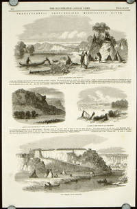
MISSISSIPPI RIVER
Transatlantic Sketches - The Mississippi River.
London.: Illustrated London News. 04-10- 1858. Two pages from The Illustrated London News of april 10 1858 pp376-377 sheet size 16 x 10 1/4 each sheet with four vignette wood engravings. Very good condition. Vignette images on first sheet include: A Sioux Encampment Upper Mississippi; Bluffs Near the Prairie Du Chien Upper Mississippi; Junction of the Missouri and Mississippi; Fort Snelling Upper Mississippi. On second sheet illustrations include: Down the Lower Mississippi from the Baton Rouge; Voyagers Ascending the Lower Mississippi; Woodchopper's Hut Lower Mississippi; and The Graveyard Lower Mississippi. The text relating to the images runs from the verso of p.376 through to the verso of p.377. This is in the form of a missive signed C.M. relating a trip down the Mississippi with emphasis on his impressions of New Orleans. . Illustrated London News. unknown
Référence libraire : 51533
|
|
|
NEW YORK HUDSON RIVER Annand George illus.
A Romance Map of the Hudson River Valley.
Chicago.: Rand McNally & Co. Copyright 1937. Color pictographic / pictorial map 23 3/4 x 18 inches 60 x 45 cm on sheet 24 3/4 x 18 3/4 inches folding to 9 1/2 x 6 1/4 inches. Number stamp to upper left of map just below cartouche and withdrawn stamp to left upper margin outside neatline have been in-painted and now not visible. Otherwise very good clean and bright condition. Cartograph by George Annand. Pictographs in the map show historical figures historical buildings etc. with a text border at left and right of historical information. Glens Falls Hudson Falls and Saratoga are located at the top of the map with New York and Long Island at the lower edge of the map. Lower left: "Copyright 1937 by Marguerite Hess Parrish Compiler"; lower centre: "Rand McNally & Co. Chicago Publisher"; lower right: "Josephine Wilhelm Wickser Consultant." . Rand McNally & Co. unknown
Référence libraire : 51614

|
|
|
AUSTRALIA MURRAY RIVER
The Murray River Passengers' Guide Book.
Murray Shipping Limited. 1922. Booklet black and white photo illustrations and folding map 30pp 11 x 5 inches stiff card wrappers softbound. Soft creases to cover interior in very good condition. This vintage guide book to the Murray River "The Nile of Australia" includes a small untitled map of Australia from Adelaide to Melbourne showing Rivers and Railways. . Murray Shipping Limited. paperback
Référence libraire : 40774

|
|
|
DENVER & RIO GRANDE
Panoramic Views Along the Denver & Rio Grande Western Pacific / The Royal Gorge Route Feather River Canon Route.
Denver & Rio Grande Western Railroad. Map copyright 04-20- 1916. Pamphlet opening out in accordion-like fashion color illustrations and map. Sheet size 8 x 52 inches folding as issued to 8 x 4 inches. Back cover creased front cover has ticket agency label at lower edge overall very good condition. One side of this vintage pamphlet includes colorful views of the Eagle River Canyon Colorado; Temple Square Salt Lake City Utah; Castle Butte California etc. the other side has information on sites climate and resorts plus a 4 panel Map of the Denver & Rio Grande Western Pacific and Connections showing Standard and Narrow Gauge Railways. . Denver & Rio Grande Western Railroad. unknown
Référence libraire : 44987

|
|
|
DENVER & RIO GRANDE
Panoramic Views Along the Denver & Rio Grande Western Pacific / The Royal Gorge Route Feather River Canon Route.
Denver & Rio Grande Western Railroad. Map copyright 06-12- 1914. Pamphlet opening out in accordion-like fashion color illustrations and map. Sheet size 8 x 52 inches folding as issued to 8 x 4 inches. 1 1/2 inch split at one fold couple of tiny edge tears and toning along the upper edge good condition. One side of this vintage pamphlet includes colorful views of the Eagle River Canyon Colorado; Temple Square Salt Lake City Utah; Castle Butte California etc. the other side has information on sites climate and resorts plus a 4 panel Map of the Denver & Rio Grande Western Pacific and Connections showing Standard and Narrow Gauge Railways. . Denver & Rio Grande Western Railroad. unknown
Référence libraire : 44988

|
|
|
BRAZIL RIO DE JANEIRO
Untitled Map of Rio de Janeiro for H. Stern
Ca. 1955. Color maps on sheet 12 x 16 folded as issued to 6 1/2 x 4 1/4 inches. Light soiling. Very good condition. One side of the sheet has a most attractive and displayable pictorial style map of the city and environs the other side has a street map of the city and beach area. Galeao Airport is on the map making it post 1952. . unknown
Référence libraire : 40411

|
|
|
NILE RIVER Dutertre drawn by. Baltard and Dequevauviller engraved by.
Egypte Moyenne. Vue d'Un Village sur la Rive Gauche du Nil. Vue de Minyeh.
Paris.: Panckouke. Ca. 1820. Copper plate engraving uncolored image approximately 17 x 18 inches on sheet 28 x 21 1/2 inches. Very good condition: light scattered foxing mainly in the margins a few 1/4 edge tears well outside plate area. Publisher's blindstamp at top right. This very large finely engraved view is plate 5 from Volume I of the Modern State section of the monumental publication "Description de L'Egypte" which documented the research of the "savants" who accompanied Napoleon Bonaparte's ambitious expedition to Egypt 1798-1801. The full title translated into English reads "Description of Egypt or the collection of observations and research made in Egypt during the Expedition of the French Army" hinting at the varied purposes of this foray into the Middle East. The European demand for information about Egypt its glorious monuments and exotic culture led to the publication of two editions of the work with engravings pulled from the same printing plates; this is from the second edition uncolored as issued. Shown is a view of a village on left bank of the Nile and a view of Minyeh; the quality of the engraving powerfully evokes the splendor of these views. . Panckouke. unknown
Référence libraire : 41081

|
|
|
ENGLAND THAMES RIVER Thompson AG. A. G.
The Thames and All That. A History of the River. cover title: The Thames - and all that. 1824-1935.
London.: The General Steam Navigation Co. . BOOKLET color pictographic map continuing over 7 full pages black and white full page photo illustrations full page black and white map full page and partial page illustrated ads 80 pages 5 1/2 x 8 1/2 inches color pictorial wrappers. Cover detached with light soiling otherwise very good condition with small rust marks around binding staples slightly affecting pictorial map. Top edge of one sheet which was incorrectly trimmed is worn where it protrudes above top of booklet. The color map: "An Historical Map of Ye Old Royal River" shows many ships and historical figures buildings and events. Much information on the Thames also advertisements. . The General Steam Navigation Co. unknown
Référence libraire : 39507

|
|
|
DENVER & RIO GRANDE
Panoramic Views Along the Denver & Rio Grande Western Pacific. The Royal Gorge Route Feather River Canon Route. The Scenic Line of the World.
Denver & Rio Grande Western Railroad. Map copyright 02-14- 1924. Pamphlet opening out in accordion-like fashion color illustrations and map. Sheet size 8 1/4 x 51 inches folding as issued to 8 1/4 x 3 3/4 inches. 1/2 inch tear to lower edge at fold a few creases light soiling and edge wear to covers good condition. One side of this vintage pamphlet includes colorful views of the Eagle River Canyon Colorado; Temple Square Salt Lake City Utah; Castle Butte California etc. the other side has information on sites climate and resorts plus a 4 panel Map of the Denver & Rio Grande Western Pacific and Connections showing Standard and Narrow Gauge Railways. . Denver & Rio Grande Western Railroad. unknown
Référence libraire : 50858

|
|
|
DELAWARE RIVER Lummis F. E. illus.
Ice on the Delaware.
New York.: Harper's Weekly. 02-12- 1887. Single-page black and white wood engraving from Harper's Weekly of February 12 1887; sheet size approx. 11 x 16 inches. Very good condition. Accompanying text on a separate sheet. View of the river frozen over with ships iced in. . Harper's Weekly. unknown
Référence libraire : 32562

|
|
|
Big River History Book Committee
Timber Trails. History of Big River and District
Big River Saskatchewan: Big River History Book Committee 1979. Hardcover. very good. 1st printing. 360pp. Octavo. Original orange cloth. Black lettering and illustration on front cover. B/W illustrations within text. Gift inscription on ffep but otherwise a clean tight copy. Community history of Big River and surrounding areas. Focusing on early settlement the air base and families histories. A great reference book for the geneologist. 1979 Big River History Book Committee hardcover
Référence libraire : 100977
|
|
|
MISSISSIPPI RIVER
Mississippi River Scenic Line. Where Nature Smiles Three Hundred Miles.
St. Paul Minnesota.: Burlington Route. 1939. Descriptive illustrated booklet providing highlights of travel on the Burlington Route line between Minneapolis/St. Paul and Chicago; 9 x 4 inches; 15 double-wide 9 x 8 inches pages; photographic illustrations. Attractive 16 x 9 inch color pictorial centerfold map of the Mississippi River from Minneapolis/St. Paul south to Nauvoo. The map depicts both the route between the Twin Cities and Chicago as well as the route from Chicago westward across the Mississippi. Very good clean condition. . Burlington Route. unknown
Référence libraire : 52198

|
|
|
The River Oaks Garden Club of Houston
A Garden Book for Houston and the Texas Gulf Coast
Pacesetter Press. Used - Very Good. Great condition for a used book! Minimal wear. Pacesetter Press unknown
Référence libraire : GRP12651261 ISBN : 0884153509 9780884153504
|
|
|
William Riviere
By the Grand Canal: A Novel
Grove Press 2005-11-29. Paperback. Good. Grove Press paperback
Référence libraire : SONG0802142389 ISBN : 0802142389 9780802142382

|
|
|
Devon River Board
Byelaws - Fisheries River Boards Act 1948; Salmon and Freshwater Fisheries Act 1923
Devon: Devon River Board 1952. First. paperback. Good-. 8vo. A very good copy. 12pp Cover corners slightly bumped. Immediate despatch from the UK. Devon River Board unknown
Référence libraire : 90017152
|
|
|
Cornwall River Authority
Angling Guide Third Edition 1971
Cornwall: Cornwall River Authority 1971. 3rd. paperback. Good. 8vo. 40pp. Pictorial yellow card covers. Soiling to front cover. Cornwall River Authority unknown
Référence libraire : 5007320
|
|
|
River Dart Steamboat Co.
Up and Down the River Dart. Souvenir of the Trip
Devon: River Dart Steamboat Co 1111. paperback. Very Good. 64mo Landscape. Rusty staples. spotting to rear cover. River Dart Steamboat Co unknown
Référence libraire : 500013259
|
|
|
Darling Diana/ Helmi Rio Photographer
Popo Danes: Bali Inspiration: Architecture for the Tropical World
Rizzoli Intl Pubns 2020. Hardcover. New. 176 pages. 12.25x8.50 inches. Rizzoli Intl Pubns hardcover
Référence libraire : __8891825042 ISBN : 8891825042 9788891825049

|
|
|
Jordan River
Praying for Strangers: An Adventure of the Human Spirit
New York: Berkley Books 2011. Book. Near Fine. Hardcover. 1st Edition. The book has a remainder mark. Berkley Books Hardcover
Référence libraire : 016704 ISBN : 0425239640 9780425239643

|
|
|
Carlos Maciel del Rio
Manual Para Proclamadores de la Palabra Spanish Edition
Liturgy Training Publications 2003-12-01. Paperback. Good. Liturgy Training Publications paperback
Référence libraire : SONG1568544235 ISBN : 1568544235 9781568544236

|
|
|
William Riviere
Kate Caterina: A Novel
Atlantic Monthly Press 2002-03-12. 1ST. Hardcover. Used:Good. Atlantic Monthly Press hardcover
Référence libraire : DADAX0871138395 ISBN : 0871138395 9780871138392

|
|
 Recevoir par e-mail
 Télécharger en PDF
 Flux RSS


