|
Caro Ina; Cain maps David
Paris to the Past: Traveling Through French History by Train
W.W. Norton 2012. Fine. Caro Ina. Paris to the Past: Traveling Through French History by Train. Cain maps David. New York: W.W. Norton 2012. 381pp. Indexed. Bibliography. 8vo. Paperback. Book condition: Near fine. W.W. Norton paperback books
Bookseller reference : UCARPAR00TM
|
|
|
Tucker Glenn; Tucker Maps WT. W. T.
Poltroons and Patriots: A Popular Account of the War of 1812 Two volumes
Bobbs-Merrill 1954. Very Good. Tucker Glenn. Poltroons and Patriots: A Popular Account of the War of 1812 Two volumes. Tucker Maps W.T. Indianapolis: Bobbs-Merrill 1954. 812pp. Indexed. Illustrated. 8vo. Cloth with gilt lettering. Book condition: Very good with lightly bumped and yellowed spines. Slipcase is very good with light rubbing and yellowing. Includes monthly bulletin of American History Publication Society. Bobbs-Merrill hardcover books
Bookseller reference : UTUCPOL00JMJ
|
|
|
Wallis Helen Keeper of Maps British Library
The Voyage of Sir Francis Drake Mapped in Silver and Gold
Friends of Bancroft Library 1979. Very Good. Wallis Helen Keeper of Maps British Library. The Voyage of Sir Francis Drake Mapped in Silver and Gold. Berkeley: Friends of Bancroft Library 1979. 26pp. 8vo. Blue wraps. Book condition: Very good. Friends of Bancroft Keepsake #27. Friends of Bancroft Library paperback books
Bookseller reference : UWALVOY00LNW
|
|
|
Kingsolver Barbara; Cartes translator Rebecca
Another America: Otra America Bilingual English / Spanish
Seal Press 1992. Fine. Kingsolver Barbara. Another America: Otra America Bilingual English / Spanish. Cartes translator Rebecca. Seattle: Seal Press 1992. 104pp. 8vo. Black cloth with gilt lettering. Signed by author. Inscribed by author. Book condition: Near fine. Inscribed by author on title page. Dust Jacket Condition: Near fine. Very slight weat along bottom edge. In protective cover. Seal Press hardcover books
Bookseller reference : RKINANO00JKN
|
|
|
Kingsolver Barbara; Cartes translator Rebeca
Another America Otra America with Spanish Translations
Seal Press 1992. Very Good. Kingsolver Barbara. Another America Otra America with Spanish Translations. Cartes translator Rebeca. Seattle: Seal Press 1992. 103pp. 12mo. Paperback. Book condition: Very good with lightly rubbed and bumped edges. Seal Press paperback books
Bookseller reference : UKINANO00CCW
|
|
|
PATCH Joseph Dorst; Fitzhugh Turner ed.; Virgil Carrington Jones intro.; Marjorie Keen maps
The Battle of Ball's Bluff Limited Edition Inscribed
Leesburg VA: Potomac Press 1958. First Edition. Limited to an unspecified number of copies. Slim octavo 23.5cm.; original cloth in white pictorial dust jacket; 2123pp.; 4 leaves of illus. printed on rectos and versos text illus. throughout map endpapers additional bookplate of maps laid in. Jacket extremities chipped and worn spine crown pulled but present three small losses to spine one touching one letter without loss of meaning. Near Fine in Good or better jacket. Inscribed and signed to local historian and educator Garland Quarles on half title page: "For: Garland R. Quarles / With best wishes / Joseph Dorst Patch. Potomac Press unknown books
Bookseller reference : 30952

|
|
|
MAPS; ENGLAND William Darton
THE COUNTIES OF ENGLAND: WITH GENERAL MAPS OF NORTH AND SOUTH WALES
London: Willaim Darton and Son 1835. Half Leather. Very Good binding. Darton's Counties of England complete with 42 decorative engraved map 3 of which are folding with original hand-coloring. The maps have attractive vignettes of sights within each county and references to the "Hundreds" and "Market Towns and Market Days". Some offsetting as is usual. This is a later state of "Complete Atlas of the English Counties" begun by Thomas Dix of North Walsham and completed by William Darton in 1822. Undated but the imprint on most maps reads "London: William Darton & Son 58 Holborn Hill" which was Darton's company name only between 1835 and 1837. Rebacked in calf with a new spine label. Very Good binding. Willaim Darton and Son unknown books
Bookseller reference : 291674

|
|
|
WWII Eastern European MAPS
Archive of 6 European World War II Maps
Archive of 6 large original World War II Maps these maps were used by US troops during the liberation of Europe. RARE ORIGINAL WORLD WAR TWO VINTAGE ALLIED FORCES EUROPEAN THEATER OF OPERATIONS Czech Republic cities and one Map of Hamburg - German . Comes from a WW2 US Army Soldier. These 6 original maps came from a US soldier that was in European theatre in WWII they are mostly in very good condition and as follows: <br/><br/>Mesto Tepla Czech Republic - size 19x24".<br/>Plzen Czech Republic 4151 - size24x19". Black and white with green overlay. <br/>Horsovsky Tyn Czech Republic 4150 - size24x19"<br/>Kralovice KraloviceCzech Republic 4051 - <br/>Czechoslovakia promotional map dated 1938. a very arge map size 34x22"<br/>Hamburg - German map. size 28x24". dated 1939 in print. <br/><br/>All maps are original and have some folds and wrinkling overall in Good Condition. unknown books
Bookseller reference : 14433
|
|
|
WWII AMERICAN US. MAPS U. S.
9 World War II Maps EUROPEAN THEATER OF OPERATIONS
Archive of 9 large World War II Maps these maps were used by US troops during the liberation of Europe. RARE ORIGINAL WORLD WAR TWO VINTAGE ALLIED FORCES EUROPEAN THEATER OF OPERATIONS Maps of German cities and one of Paris France. Comes from a WW2 US Army Soldier. These 69 original maps are mostly in very good condition and as follows: <br/><br/>Magdeburg Germany map - US Army Air Map of Magdeburg "First Edition" Sheet M.53 1:250000. 1943. With handwriting in upper right corner. 30x26"<br/>KasselGermany map- US Printed Map of Kassel region of Germany. "Emergency Road Map." Color. First Edition. sheet L52 Based on 1938 map supplemented by other sources collected during the war. 22x28"<br/>Dusseldorf Germany map- same as above but faded and with some highlighting some writing. sheet k52<br/>Hanover Germany map- same as above sheet L53. Printed 1943.<br/>Berlin Germany map- similar to above but "Army/Air" not Emergency Road. Sheet N53. Published by War Office 1943<br/>Halle Germany map- Halle Saale is a city in the southern part of the German state Saxony-Anhal. Sheet M52. "War and Navy Department Agencies only. Not for sale or distribution." 1943. <br/>Wernigerode Germany- town in the district of Harz Saxony-Anhalt German 19x24. Sheet 4130. FIrst Edition. US "Published by War Office 1944." B&W. exposed to water. Hardened. y<br/>Julich Germany- town in the district of Düren in the federal state of North Rhine-Westphalia Germany "Published by War Office 1944." G.S.G.S. No. 4507. 35x30"<br/>Paris France map - 42x34 - U.S. 1944. The Liberation of Paris took place from 19 August 1944 until the German garrison surrendered on 25 August 1944. Paris had been ruled by Nazi Germany since the signing of the Second Compiègne Armistice on 22 June 1940. unknown books
Bookseller reference : 14434

|
|
|
WWII GERMAN MAPS
Collection of 10 German-made WWII-era maps of cities and Factories
Collection of 10 German-made WWII-era maps. All printed in German sometimes with foreign translations.<br/><br/>Includes arial bombing maps of Chesterfield Tube Works Great Britain Dec. 1942 showing a geographical arial photograph of the factory area and an overlay of roads bridges and potential targets. The German forces tried to bomb Chesterfield and the railway tracks nearby where the Tube Works produced important cylinders and compressors for the war effort. Instead their bomb fell on a golf course 4 miles away doing no harm. Bears the warning: "Nur fur den Diensfgebrauch" or "For Internal Use Only." 12"x12.5" 2 pg<br/><br/>Also includes a "Map of the Former Czechoslovakia" In German: "Karte der ehemaligen Tschechoslowakei". The German occupation of Czechoslovakia lasted from1938 to 1945 beginning with the Nazi annexation of the northern and western border regions known collectively as the Sudetenland under terms outlined by the Munich Agreement. Hitler's pretext for this effort was the alleged privations suffered by the ethnic German population living in those regions. Czechoslovakia was finally liberated with the Allied Victory in 1945. Map in black and white with red elevations. Bears the large tage at the top: "Sondersausgabe!" or "Special Edition!" Also includes a map of a Czech city which played an important part in World War II History. Situated at the very end of the Sudentenland the borders of the Third Reich were literally on Plzen's outer limits. Occupied by Nazi forces starting in 1939 and divided by the loyalties of its half-German population Plzen was finally liberated with the rest of Czechoslovakia in 1945. The map is written in German with Czech translation of each heading. It has seen substantial use and the key has been cut out of the upper left side. 37"x27"<br/><br/>Koln - German map - Near mint condition. 22x17". Translates to "Cologne" which is a city in Germany.<br/><br/>Umgebung von Wein - German. 44x34"<br/><br/>"Deutschesreich" translates to "German Empire"- western half- 56x42" extra large German map - over outline map - no date<br/><br/>Frankreich - same as German Empire. Shows paris and london. <br/><br/>Italien - same as above.<br/><br/> "Blatt Sudost" Translates to "Southeast Sheet" - Ubersichtskarte translates to "Overview Map" - 56x42". Color. Attractive gold pink and blue. 1:1000000.See photos. no date. Very nice condition on printed side. unknown books
Bookseller reference : 14430

|
|
|
Tucker Glenn; maps by Dorothy Thomas Tucker
Dawn Like Thunder: The Barbary Wars and the Birth of the U.S. Navy
Indianapolis: Bobbs-Merrill 1963. 1st. Hardcover. Book fine Dust jacket fine. The dust jacket is price clipped and has minor chips and closed tears to the extremities. <br/><br/> Bobbs-Merrill hardcover books
Bookseller reference : 9010503
|
|
|
Carey Brian Todd; tactical maps illustrated by Joshua B. Allfree; regional maps illustrated by John Cairns
Hannibal's Last Battle: Zama and the Fall of Carthage
Yardley Pennsylvania: Westholme Publishing 2008. 1st. Hardcover. Book fine Dust jacket fine. <br/><br/> Westholme Publishing hardcover books
Bookseller reference : 9009390 ISBN : 1594160759 9781594160752

|
|
|
Caribbean Maps: Norie J. W.
THE ISLAND OF ANTIGUA. Revised by J.W. Norie 1827
Antigua but actually Philadelphia: R.B. Eldridge & Co. 1860. Lithographic sheet map 20 1/2 x 26 1/2 inches. Backed with contemporary blue paper. Light foxing and toning. A few small tears in margins. Very good. An unusual lithographic edition of Norie's 1827 revision of this handsome chart lithographed by Wagner & McGuigan in Philadelphia. A statement in the cartouche reads: "Presented by R.B. Eldridge Antigua to Captain Andrew Tyler." The captain's name is accomplished in manuscript. R.B. Eldridge is not listed in Tooley's DICTIONARY OF MAPMAKERS and appears to be unrelated to publisher of charts George Eldridge. It seems most likely that he was rather an Antigua merchant who commissioned a reprint of the chart for complimentary distribution to sea captains. A handsome piece. R.B. Eldridge & Co. unknown books
Bookseller reference : WRCAM48522

|
|
|
Texas Maps: Lapie M.
CARTE DE L'AMERIQUE SEPTENTRIONALE
Paris 1842. Partially colored map 27 x 20 inches. Center fold some foxing else very nice. Archival matting and protected with Mylar sheet. Shows all of North America with Russian British U.S. and Mexican possessions. Texas is shown as part of the United States with the Nueces as the boundary line with Mexico. unknown books
Bookseller reference : WRCAM9643

|
|
|
USSR Soviet Union Communist Era Economics Maps
1959 - 1965 Map of the Soviet Union Giving the Results of Economic Planning Over 7 Years with Map Showing the Economic Districts of the USSR
USSR 1965. The 7 year plan economic map with good lithographic color key gives interpretation and on back various charts show growth over time. The district map in black and white with numbers keyed to the list of districts on the back; text entirely in Cyrillic. Approx. 9 3/4" x 13" size; a little edge-wear one short 1/4" closed edge-tear; in very good condition. First Edition. Not Bound. Very Good. paperback books
Bookseller reference : 25042

|
|
|
Maps Fite Emerson D. & Archibald Freeman
A Book of Old Maps delineating American History from the Earliest Days down to the close of the Revolutionary War
Chicago: Harvard University Press 1926. First edition. Illustrated with 74 maps with great textual descriptions. 299 pp. 1 vols. Folio. Original blue cloth some very minor rubbing else fine. First edition. Illustrated with 74 maps with great textual descriptions. 299 pp. 1 vols. Folio. Harvard University Press unknown books
Bookseller reference : 38565
|
|
|
Major Raymond H. Fredette; B/w Photographs and Maps Illustrator; Hanson W. Baldwin Foreword; Sir John Slessor Afterword;
The Sky on Fire: The First Battle of Britain 1917-1918 and the Birth of the Royal Air Force 1st Edition
Holt Rinehart and Winston 1966-01-01. First Edition. Hardcover. Very Good. First Edition stated. No dust jacket. Gray and orange cloth boards- cloth lightly rubbed at the top edge of the spine. Clean has a good binding no marks or notations. Holt, Rinehart and Winston hardcover books
Bookseller reference : 193708

|
|
|
Stanford's Library Maps
LONDON ATLAS MAP OF CAPE OF GOOD HOPE & THE ORANGE FREE STATE
London: Edward Stanford. Hard Cover. Very Good binding. Engraved on Copper Plates in the Finest Style of the Art; "Property of M.I.D. G-2" stamped in atlas. No markings on fold-out map. Red cloth covers with beige title label. Light edgewear to head and tail of spine.Hardcover with Fold-out Map. Very Good binding. Edward Stanford unknown books
Bookseller reference : 228477

|
|
|
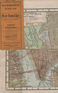
Maps; New York City
HAMMOND'S GUIDE MAP OF NEW YORK CITY: Manhattan and the Bronx
New York: Wehman Brothers Publishers 1913. Very good. Folding color map. Measuring approximately 18" x 36" when unfolded. In original printed card wrapper. Verso a thorough printed street index. Mild handling wear toning. A few tiny holes near fold corners. Overall well preserved; very good. <br/><br/>An impressive color map of the island of Manhattan and the Bronx. Scale is 1" equals 1/2 mile and includes railroads subways elevated railroads surface railroads and proposed railroads. An uncommon early 20th Century New York City street map. Wehman Brothers Publishers unknown books
Bookseller reference : 15611
|
|
|
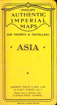
Philips Authentic Imperial Maps
Philips Authentic Imperial Maps For Tourists and Travelers: Asia
Liverpool: George Philip and Son nd. Hardcover. Very good. Boards rubbed and darkened cloth backing slightly tanned else very good. <br/><br/> George Philip and Son hardcover books
Bookseller reference : 43520
|
|
|
Minnesota Rivers Maps
Snake Upper Red and Minnesota Rivers Minnesota; Reservoirs at Sources of rock River Wisconsin and Illinois
Washington DC: U. S. Congress. Very Good. 1881. Pamphlet. Snake Upper Red and Minnesota Rivers Minnesota; Reservoirs at sources of Rock River Wisconsin and Illinois. Letter from the Secretary of War transmitting surveys .United States. War Department. 1881. 16 pages maps 2 folded ; 23 cm. Washington Govt. Print. Off. 1881. Disbound Pamphlet. The contents are nice and the 2 folding maps are bright and clean. . U. S. Congress unknown books
Bookseller reference : 74181
|
|
|
Halliday FE. editor and introduction; maps by John Norden F. E.
Richard Carew of Antony: The Survey of Cornwall &c
London: Andrew Melrose 1953. Hardcover. 334p. cloth-covered boards 6x9.25 inches frontispiece portrait of Carew corners bumped boards have a stained/mottled appearance offsetting to endpapers from dj old price stamped on front paste-down endpaper else good condition in a worn dj with a small splash stain on the spine panel. Andrew Melrose hardcover books
Bookseller reference : 264337

|
|
|
maps; French Revolution
Maps of Sites of the War and Counter-Revolution of France 1792-1794
unknown: unknown likely early 1800s. Ephemera. Very Good. A collection of 8 engraved maps 420 x 280 mm including wide margins numbered in Arabic or Roman numerals see below otherwise seemingly uniform. From an unknown source. It includes: 1 Bombardement de Lille par l'Armee Autrichienne en 1792 with the stamp of Depot de la Guerre Bibliotheque in the top margin; 2 Siege de la Citadelle d'Anvers par l'Armee Francaise en 1792; III Siege de Valenciennes par l'Armee Coalisee Anglaise Hannovrienne et Autrichienne en 1793; VIII Siege d'Ypres par l'Armee Francaise en 1794; IX Siege de Charleroy par les Francais en 1794; X Siege de Landrecies par les Francais en 1794; XI Siege du Quesnoy par les Francaise in 1794; and XIII Siege de Nieuport par l'Armee Francaise en 1794. A bit foxed; flattened crease down the middle from folding these were perhaps pulled from a book where they were mounted on stubs along the crease. <br/><br/> [unknown] unknown books
Bookseller reference : D7401
|
|
|
maps
Etablissement Militaire de St. Bernard. Atlas des batiments
c. early 19th century. Hardcover. Very Good. Half cloth and marbled paper over boards handwritten label on upper board; oblong folio 460 x 360 mm; entirely handwritten and drawn in black ink on the rectos only with "tableau des batiments militaires" and 7 maps. Boards heavily scuffed; binding shaken; some dusty finger-smudges here and there. <br/><br/> hardcover books
Bookseller reference : LD7400
|
|
|
J. R. R. Tolkien; Edited with an Introduction Commentary Index and Maps by Christopher Tolkien
Unfinished Tales of Numenor and Middle-earth
Boston: Houghton Mifflin 1980. First Printing with complete number row.Near Fine very scant and faint foxing to end pages in a Fine dust jacket. Map attached at rear. Uncommon in such exceptional condition a lovely copy. . First American Edition. Cloth. Near Fine/Fine. 8vo. Houghton Mifflin Hardcover books
Bookseller reference : 005434 ISBN : 0395299179 9780395299173

|
|
|
Hogarth David George; Bartholomew J. G. maps
THE PENETRATION OF ARABIA
New York: Frederick A. Stokes Company 1904. First American Edition. Hardcover. Octavo xiii 359 pages; VG-; bound in publisher's decorated green cloth gilt and black titling to spine; mild wear and rubbing primarily to head of spine and corners; bookplate to ffep; with 54 maps and plates; scarce; LJ consignment; shelved case 8 1/2. Also published in London the same year.;. 1336482. Shelved Dupont Bookstore. Frederick A. Stokes Company hardcover books
Bookseller reference : 1336482

|
|
|
Parker Robert M. author; Wong Jeanyee maps; Wormell Christopher drawings
BURGUNDY : A COMPREHENSIVE GUIDE TO THE PRODUCES APPELLATIONS AND WINES SIGNED
New York: Simon and Schuster 1990. Hardcover. Octavo; VG/VG-; Hardcover with DJ; DJ spine black with gold print; DJ has slight edgewear but is clean and bright; Boards quarter bound with red cloth to spine and grey paper to boards clean and strong; Text block clean and tight; Signed in ink by the author on front endpaper; 1052 pages illustrated 2-color. 1334823. FP New Rockville Stock. Simon and Schuster hardcover books
Bookseller reference : 1334823 ISBN : 0671633783 9780671633783

|
|
|
Guadalupi Gianni and Manguel Alberto Illustrated by Graham Greenfield Maps and Charts by James Cook
The Dictionary of Imaginary Places
New York: Macmillan Publishing Co 1980. First Edition First Printing. Hardcover. Quarto; VG/VG; illustrated spine with white text; jacket has some rubbing and scuffing minor spotting on verso side fold in upper corner of front flap; boards are strong spine slightly cocked; textblock has spotting on head and fore edges otherwise clean; pp 438. 1293597. Full-priced Rockville. Macmillan Publishing Co hardcover books
Bookseller reference : 1293597 ISBN : 0025793101 9780025793101
|
|
|
Lindbergh Anne Morrow; Lindbergh Charles A. maps by;
North to the Orient
New York: Harcourt Brace and Company 1935. First Edition. Hardcover. 10mo; pp 255; G/Poor; blue spine with ivory text; dust jacket has noticeable chips to edges; some toning to exterior; mylar wraps; cloth has slight wear to exterior; minor wear to corners; strong boards; text block has age toned exterior edges; illustrated endpapers; previous owner's name to verso of ffep; frontispiece; illustrated; interior clean;. 1319874. FP New Rockville Stock. Harcourt, Brace and Company hardcover books
Bookseller reference : 1319874
|
|
|
Dunn John L. & Garret Kimball L. Text; Shultz Thomas R. & House Cindy Illustrations; Tackett Sue A. & Rosche Larry O. Maps
WARBLERS OF NORTH AMERICA ROGER TORY PETERSON
Norwalk CT: Easton Press 1997. Collector's Edition of the Fiftieth Anniversary Edition. Small octavo; VG/No-DJ; Dark blue leather spine with gilt lettering; Cover has gilt bird design and titles on front very light wear to edges some rubbing and blemishes to front cover; A.E.G. minimal rubbing to gilt edges of text block; Bound-in bookmark; Binding is tight; Text block is pristine; NOTE: No leaflet or other Easton Press ephemera; 656 pp. 1206114. Rockville Non-Retail Listings. Easton Press unknown books
Bookseller reference : 1206114
|
|
|
Baltimore Division Road Maps VI
Baltimore and Ohio Railroad Lines Between Connellsville PA Including W&P and P&W and P&LE and other Branches
Baltimore: Safety Through Knowledge 1989. Other. Tall Octavo; VG-; Paperback with comb binding; Covers have moderate stains to the front and rear; Fore edge has minor foxing otherwise text block is clean; 116p. 1323176. FP New Rockville Stock. Safety Through Knowledge unknown books
Bookseller reference : 1323176
|
|
|
DeVoto Bernard; Raisz Erwin maps by;
The Course of Empire
Boston: Houghton Mifflin and CompanyH 1952. Hardcover. Octavo; pp 647; VG-/G-; dark yellow spine with beige text; dust jacket has sunned spine; modest wear to exterior; some rubbing to edges; price clipped flap; mylar wrap; cloth has only light to exterior; clean strong boards; text block has slight foxing to exterior edges; pictorial endpapers; illustrated; deckled fore edge; tight binding;. 1329900. FP New Rockville Stock. Houghton, Mifflin and CompanyH hardcover books
Bookseller reference : 1329900
|
|
|
Toland John author; Kuhl Jerome maps
THE BATTLE OF THE BULGE LANDMARK BOOKS 114
New York: Landmark Books Random House 1966. Hardcover. Octavo; G-/no DJ; Hardcover w/out DJ; Spine white with red print; Boards in illustrated cloth wear to corners and spine caps toning to spine edgewear/shelfwear; Text block has name in ink on front endpapers cracked hinges front and rear clean text light age-toning to paper; 178 pages frontispiece illustrated b&w. 1326637. FP New Rockville Stock. Landmark Books, Random House hardcover books
Bookseller reference : 1326637
|
|
|
Folding Maps
Africa Orientale Italiana. 12 of 37 unbound folded four-page Tav. tables/sheets: Tav. 3 - Cassala; Tav. 4 - Asmara; Tav. 5 - Hodeida; Tav. 6 - Gallabat: Tav. 8 - Assab; Tav. 9 - L. Tana; Tav. 11 - Gibuti; Tav. 14 - Neggio; Tav. 17 - Berbera; Tav. 20 - Gimma; Tav. 25 - L. Stefania; Tav. 30 - L. Rodolfo
Milano: Touring Club Italiano 1936. Very Good. 12 of 37 unbound sheets. 4p.center 2 pages are 34 cm. x 25 cm. map. Partly colored. Scale: 1:1000000. Italian text. <br/><br/> Touring Club Italiano unknown books
Bookseller reference : 91525

|
|
|
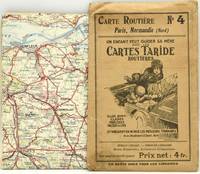
Cartes Taride
ROADMAP CARTE TARIDE - ROUTIERE NO. 4. PARIS NORMANDIE NORD
Paris: Imp. Gaillac. A roadmap of France. Measuring about 73.5 x 92.5 cm unfolded. Housed in the publisher's paper sleeve. Imp. Gaillac unknown books
Bookseller reference : 290392
|
|
|
Fajana A. & B. J. Biggs illustrations by C. Pearson maps by G. Woodman
Nigeria in history
Ikeja: Longman Nigeria Ltd 1977. Paperback. viii 230p. preface appendices illustrations maps lightly-worn reprint trade paperback in red pictorial wraps. Longman Nigeria Ltd paperback books
Bookseller reference : 170527 ISBN : 0582602424 9780582602427

|
|
|
Painter George D. with illustrations maps drawn by Samuel H. Bryant
Proust; the early years
Boston: Atlantic Monthly Press/Little Brown and Company 1959. Hardcover. xvii 435p. 8p. photos later printing cloth edgeworn dj. Atlantic Monthly Press/Little, Brown and Company hardcover books
Bookseller reference : 94939

|
|
|
Philip's Series of Travelling Maps
North America
London UK: George Philip & Son Ltd. Good. 0. Hardcover. Dark blue cloth boards with gilt title. Map folds out to 22 x 28 inches. No date circa 1900s. Boards worn on edges corners bumped spine starting to split.; Book; 12mo - over 6¾ - 7¾" tall . George Philip & Son, Ltd. hardcover books
Bookseller reference : 006893

|
|
|
Clifford Hugh. Bartholomew J. G. Maps by. Crocco M. Di Preface
FURTHER INDIA. Being the Story of Exporation from the Earliest Times in Burma Malaya Siam and Indo- China
Bankok: White Lotus Co 1990. 1st Edition. Illustrated laminated wrappers with black title lettering printed to front wrapper and spine. Last page is dog-eared PO stamp to preliminary title page. A VG copy. xi 1 blank 378 2 pp including appendix. Many b/w illustrations and maps. One fold-out image. 8-1/2" x 6" <br/><br/> White Lotus Co unknown books
Bookseller reference : 34882

|
|
|
Foreign Economic Administration. Maps and Graphics Division Enemy Branch
China Transportation Map
Washington D.C.: Maps and Graphic Division 1946. 1st. revision March 1946. Edges browned 4 inch and 2 inch tears on folds one with small loss at double fold small chip and stain to margins top and bottom some minor edge wear and marginal tears; a good copy. 1 pp. 110 x 90 cm. Color map of China's transportation routes during the war. Scale ca. 1:2750000; E 1000--E 1260/N 420--N 180. Map no. 1379 June 15 1945. OCLC shows only one copy at the LOC of this revised copy. Maps and Graphic Division unknown books
Bookseller reference : 33453
|
|
|
MAPS
BIRD'S EYE VIEW OF NARA
1900. MAPS. BIRD'S EYE VIEW OF NARA. Osaka: K. Kawakami c. 1900. Folding panorama c. 22" x 25" colored green and view. Some notes by contemporary tourist added to key. Heavily worn at folds and edges partly separated at folds. unknown books
Bookseller reference : 42458
|
|
|
MAPS
MAPS FOR THE JEWISH SCHOOL PORTFOLIO 1
1968. MAPS MAPS FOR THE JEWISH SCHOOL PORTFOLIO 1. New York: Jewish Education Committee Press January 1968. Ten color maps 9 1/2 x 14 inches plus bonus map of the Six Day War. Includes maps of ancient history and contemporary Israel as well as Eastern Europe. Maps fine original envelope has closed tears light soil. unknown books
Bookseller reference : 79979
|
|
|
MAPS
VINLAND MAP AND THE TARTAR RELATION
1965. MAPS. THE VINLAND MAP AND THE TARTAR RELATION. By R.A Skelton et al. New Haven: Yale University Press 1966. Fourth printing. The historian John Muir Whitehill's copy with his notes on the preliminary leaves. 4to. red paper-covered boards; 291pp. A very good copy with a little scuffing to the boards. unknown books
Bookseller reference : 54016
|
|
|
Southern Pacific Company
Map of San Francisco: Showing points of special interest to attendants the Fifth International Convention of the Epworth League July 18-21 1901
<p>Map of San Francisco: Showing points of special interest to attendants the Fifth International Convention of the Epworth League July 18-21 1901 folding map of 21" x 28" printed in black & red.With numbered locations of places of Methodist interest and historical. Verso of map with 23 panels detailing trips excursions to Yosemite Valley Southern California including Pasadena Redlands Riverside Palo Alto Santa Cruz Lick Observatory. Very good minor wear; short tears at folds.</p><p>San Francisco before the 1906 devastating earthquake.</p> unknown books
Bookseller reference : 2221875

|
|
|
photographs; cartes de visite
Collection of Nineteenth Century Photographs Cartes-de-Visite Cabinet Cards
England 1800. Near Fine. Two custom cases gilt-stamped morocco containing 34 cabinet cards 4.25 by 6.5 inches and 45 cartes-de-visite 2.5 by 4 inches. Cases are in excellent condition just a little scuffed along the edges; images mostly albumens are remarkably crisp and clean some of them in original glassine envelopes. Produced by Cromack of Scarborough Brigham also Scarborough Elliott and Fry Portman Square Frank M. Sutcliffe Whitby Yorkshire and others these formal portraits include men women and children sometimes the same image is repeated and sometimes the same face is repeated though in a different setting or posture. <br/><br/> unknown books
Bookseller reference : D4116
|
|
|
MAPS BRICKER Charles
LANDMARKS OF MAPMAKING
NY THOMAS Y. CROWELL 1968 1976 1976. DUST JACKET UNCLIPPED FIRST AMERICAN EDITION VERY GOOD. 1st Edition. Hardcover. NY, THOMAS Y. CROWELL [1968, 1976] hardcover books
Bookseller reference : 160565
|
|
|
Brion, de la Tour, L
Cercles de Bavière, de Franconie et de Souabe: divisés en toute leur Principautés et provinces. Altkolorierter Kupferstich mit Flächenkolorit.
Paris, Desnos, 1765. Blattgröße 26 x 34 cm. Bildgröße 23,3 x 26 cm.
Bookseller reference : 28250

|
|
|
Maier, Nataly
Handmaps.
Bielefeld : Kerber, 1999. 134 S. Ill. Gr. 8°. Geb. in ill. OPpbd.
Bookseller reference : 30644
|
|
|
Robson, John
Captain Cook's World. Maps of the Life and Voyages of James Cook R.N.
New Zealand, Random House, 2000. 211 p. with 128 maps and a gazetteer. 30,5 x 25 cm, hardcover with original wrappers.
Bookseller reference : 23956
|
|
|
Faupel, W. John
Faupel's Catalogue Nr. 104.
East Grinstead, Februar 1993. 18 n.n. SS., zahlreiche s.w. Abbildungen. Ca. 29 x 14, 5 cm, illustr. original Broschur, klammergeheftet.
Bookseller reference : 23971
|
|
 Receive by email
 Download as PDF document
 RSS feed
