|
Des Barres Pamela
Let's Spend the Night Together: Backstage Secrets of Rock Muses and Supergroupies
Chicago Review Press. PAPERBACK. 1556527896 Brand NewVCF . New. Chicago Review Press paperback
书商的参考编号 : OTF-S-9781556527890 ???????? : 1556527896 9781556527890

|
|
|
Des Barres Pamela
Let's Spend the Night Together: Backstage Secrets of Rock Muses and Supergroupies
Chicago Review Press 2008. Trade Paperback. Fine. Inscribed By Author. Book is in excellent condition. Binding is solid and square covers have sharp corners exterior shows no blemishes text/interior is clean and free of marking of any kind. Marked ""First Printing"" on publisher's page. Inscribed by Pamela des Barres. Chicago Review Press paperback
书商的参考编号 : 137898 ???????? : 1556527896 9781556527890

|
|
|
Des Barres Pamela
Let's Spend the Night Together: Backstage Secrets of Rock Muses and Supergroupies
Chicago Review Press. New. Special order direct from the distributor Chicago Review Press unknown
书商的参考编号 : ING9781556527890 ???????? : 1556527896 9781556527890
|
|
|
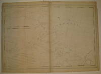
DES BARRES Joseph Frederick Wallet 1721 1824.
Lower Manhattan and the North Shore of Long Island.
London: Des Barres ca 1776. DES BARRES Joseph Frederick Wallet 1721-1824. Lower Manhattan and the North Shore of Long Island. London: Des Barres ca 1776. 2 sheets joined 30 x 48 inches. A fine engraved chart of lower Manhattan and the north shore of Long Island showing the East River passage through Hell Gate Flushing Bay Hampstead Bay Oyster Huntington Bay Cow Harbour etc lower edge damaged with loss to the image and imprint old vertical folds strengthened on verso. A magnificent chart from Des Barres's superb atlas The Atlantic Neptune published for the use of the Royal Navy of Great Britain. under the Directions of the Right Honble. the Lords Commissioners of the Admiralty. London 1774-1779 which included a comprehensive survey of the coasts of Nova Scotia the coasts and harbors of the Gulf and River of St. Lawrence and the Atlantic coast of North America from New York to Mexico and New England in more than 100 engraved charts views and elevations. Des Barres's service to the British Crown began in about 1752 when he enrolled as a cadet at the Royal Military Academy at Woolwich near London. Founded in 1741 the Academy was established to teach all the branches of mathematics necessary for men who would serve in the Artillery or as Engineers. Des Barres had already received an extensive education in his native Switzerland where he had studied both applied and theoretical mathematics at the University of Basle. Upon the completion of his training he became one of the first officers to be commissioned in the newly formed Royal American Regiment. Thus it was that at the close of the French and Indian War Des Barres was sent to America by the British Admiralty to survey the coasts of the Maritime Provinces. These provinces so recently acquired from France had never been adequately mapped and Des Barres spent the next ten years constructing a series of charts of unparalleled accuracy and beauty. Ultimately the project was expanded to include the entire Atlantic and gulf coasts of North America and his findings were published in the monumental "Atlantic Neptune". Copies of The Atlantic Neptune were compiled as they were ordered principally for naval captains or merchant mariners and therefore no standard collation exists and no two recorded copies will contain the same compliment of charts nor be bound in exactly the same sequence. "Nautical charting took an unprecedented leap toward greater precision and graphic sophistication with the publication of Des Barres's Atlantic Neptune. The Neptune provided the first generally accurate charts of many areas and it was relied upon well into the nineteenth century. Des Barres also standardized many of the symbols such as for navigational hazards that are found on nautical charts to this day. Not only were Des Barres's charts technically superior to earlier works but they were also objects of fine printing and possessed an artistry that transcended their utilitarian purpose. Moreover this was achieved on works that were often breathtakingly large in scale with some charts measuring over ten feet in length. Most of the surveys on which the charts of the Neptune were based were conducted between 1763 and 1773. Des Barres was then commissioned to assemble these surveys which included his own fine work in Nova Scotia prepare their engraving and have them bound into usable format. Surveys of the New York and New England areas were carried out by various officers under the command of Major Samuel Holland one of the most capable of all colonial cartographers. In some but not all cases Des Barres provided the names of the actual surveyors of the charts. When war with the American colonies broke out the need for good charts of American waters became imperative and in the years prior to the war Des Barres project was given high priority. Between 1776 and 1779 Des Barres and his more than twenty assistants had taken over two London townhouses to complete the Neptune" Paul E. Cohen and Robert T. Augustyn Manhattan in Maps 1527-1995 New York 1997 pp.66-69. . [London: Des Barres, ca 1776]. unknown
书商的参考编号 : 72map343

|
|
|
DES BARRES Joseph Frederick Wallet 1721 1824.
Lower Manhattan and the North Shore of Long Island.
London: Des Barres ca 1776. DES BARRES Joseph Frederick Wallet 1721-1824. Lower Manhattan and the North Shore of Long Island. London: Des Barres ca 1776. 2 sheets joined 30 x 48 inches. A fine engraved chart of lower Manhattan and the north shore of Long Island showing the East River passage through Hell Gate Flushing Bay Hampstead Bay Oyster Huntington Bay Cow Harbour etc. A magnificent chart from Des Barres's superb atlas The Atlantic Neptune published for the use of the Royal Navy of Great Britain. under the Directions of the Right Honble. the Lords Commissioners of the Admiralty. London 1774-1779 which included a comprehensive survey of the coasts of Nova Scotia the coasts and harbors of the Gulf and River of St. Lawrence and the Atlantic coast of North America from New York to Mexico and New England in more than 100 engraved charts views and elevations. Des Barres's service to the British Crown began in about 1752 when he enrolled as a cadet at the Royal Military Academy at Woolwich near London. Founded in 1741 the Academy was established to teach all the branches of mathematics necessary for men who would serve in the Artillery or as Engineers. Des Barres had already received an extensive education in his native Switzerland where he had studied both applied and theoretical mathematics at the University of Basle. Upon the completion of his training he became one of the first officers to be commissioned in the newly formed Royal American Regiment. Thus it was that at the close of the French and Indian War Des Barres was sent to America by the British Admiralty to survey the coasts of the Maritime Provinces. These provinces so recently acquired from France had never been adequately mapped and Des Barres spent the next ten years constructing a series of charts of unparalleled accuracy and beauty. Ultimately the project was expanded to include the entire Atlantic and gulf coasts of North America and his findings were published in the monumental "Atlantic Neptune". Copies of The Atlantic Neptune were compiled as they were ordered principally for naval captains or merchant mariners and therefore no standard collation exists and no two recorded copies will contain the same compliment of charts nor be bound in exactly the same sequence. "Nautical charting took an unprecedented leap toward greater precision and graphic sophistication with the publication of Des Barres's Atlantic Neptune. The Neptune provided the first generally accurate charts of many areas and it was relied upon well into the nineteenth century. Des Barres also standardized many of the symbols such as for navigational hazards that are found on nautical charts to this day. Not only were Des Barres's charts technically superior to earlier works but they were also objects of fine printing and possessed an artistry that transcended their utilitarian purpose. Moreover this was achieved on works that were often breathtakingly large in scale with some charts measuring over ten feet in length. Most of the surveys on which the charts of the Neptune were based were conducted between 1763 and 1773. Des Barres was then commissioned to assemble these surveys which included his own fine work in Nova Scotia prepare their engraving and have them bound into usable format. Surveys of the New York and New England areas were carried out by various officers under the command of Major Samuel Holland one of the most capable of all colonial cartographers. In some but not all cases Des Barres provided the names of the actual surveyors of the charts. When war with the American colonies broke out the need for good charts of American waters became imperative and in the years prior to the war Des Barres project was given high priority. Between 1776 and 1779 Des Barres and his more than twenty assistants had taken over two London townhouses to complete the Neptune" Paul E. Cohen and Robert T. Augustyn Manhattan in Maps 1527-1995 New York 1997 pp.66-69. . [London: Des Barres, ca 1776]. unknown
书商的参考编号 : 72map348

|
|
|
Des Barres Joseph F. W. Joseph Frederick Wallet
Nautical remarks and observations on the coasts and harbours of Nova Scotia : surveyed to orders form the Right Honble. the Lords Commissioners of the Admiralty for the use of the Royal Navy of Great-Britain 1778 Leather Bound
2019. Leather Bound. New. Leather Binding on Spine and Corners with Golden Leaf Printing on round Spine. Reprinted in 2019 with the help of original edition published long back 1778. This book is printed in black & white sewing binding for longer life Printed on high quality Paper re-sized as per Current standards professionally processed without changing its contents. As these are old books we processed each page manually and make them readable but in some cases some pages which are blur or missing or black spots. If it is multi volume set then it is only single volume if you wish to order a specific or all the volumes you may contact us. We expect that you will understand our compulsion in these books. We found this book important for the readers who want to know more about our old treasure so we brought it back to the shelves. Hope you will like it and give your comments and suggestions. Lang: - eng Pages 65. EXTRA 10 DAYS APART FROM THE NORMAL SHIPPING PERIOD WILL BE REQUIRED FOR LEATHER BOUND BOOKS. FOLIO EDITION IS ALSO AVAILABLE. hardcover
书商的参考编号 : LB1111005715113
|
|
|
Des Barres Joseph F. W. Joseph Frederick Wallet
Nautical remarks and observations on the coasts and harbours of Nova Scotia surveyed to orders form the Right Honble. the Lords Commissioners of the Admiralty for the use of the Royal Navy of Great-Britain / by J.F.W. Des Barres . 1778
2020. Paperback. New. Lang: - eng Pages 65. Reprinted in 2020 with the help of original edition published long back 1778. This book is Printed in black & white sewing binding for longer life with Matt laminated multi-Colour Soft Cover HARDCOVER EDITION IS ALSO AVAILABLE Printed on high quality Paper re-sized as per Current standards professionally processed without changing its contents. As these are old books we processed each page manually and make them readable but in some cases some pages which are blur or missing or black spots. If it is multi volume set then it is only single volume if you wish to order a specific or all the volumes you may contact us. We expect that you will understand our compulsion in these books. We found this book important for the readers who want to know more about our old treasure so we brought it back to the shelves. Any type of Customisation is possible with extra charges. Hope you will like it and give your comments and suggestions. paperback
书商的参考编号 : PB1111009164103
|
|
|
Des Barres Joseph F. W. Joseph Frederick Wallet
Nautical remarks and observations on the coasts and harbours of Nova Scotia surveyed to orders form the Right Honble. the Lords Commissioners of the Admiralty for the use of the Royal Navy of Great-Britain / by J.F.W. Des Barres . 1778 Hardcover
2020. Hardcover. New. Lang: - eng Pages 65. Reprinted in 2020 with the help of original edition published long back 1778. This book is Printed in black & white Hardcover sewing binding for longer life with Matt laminated multi-Colour Dust Cover Printed on high quality Paper re-sized as per Current standards professionally processed without changing its contents. As these are old books we processed each page manually and make them readable but in some cases some pages which are blur or missing or black spots. If it is multi volume set then it is only single volume if you wish to order a specific or all the volumes you may contact us. We expect that you will understand our compulsion in these books. We found this book important for the readers who want to know more about our old treasure so we brought it back to the shelves. Any type of Customisation is possible with extra charges. Hope you will like it and give your comments and suggestions. hardcover
书商的参考编号 : 1111009164103
|
|
|
Des Barres Joseph F. W. Joseph Frederick Wallet
Nautical remarks and observations on the coasts and harbours of Nova Scotia : surveyed to orders form the Right Honble. the Lords Commissioners of the Admiralty for the use of the Royal Navy of Great-Britain 1778 Hardcover
2020. Hardcover. New. Lang: - eng Pages 65. Reprinted in 2020 with the help of original edition published long back 1778. This book is Printed in black & white Hardcover sewing binding for longer life with Matt laminated multi-Colour Dust Cover Printed on high quality Paper re-sized as per Current standards professionally processed without changing its contents. As these are old books we processed each page manually and make them readable but in some cases some pages which are blur or missing or black spots. If it is multi volume set then it is only single volume if you wish to order a specific or all the volumes you may contact us. We expect that you will understand our compulsion in these books. We found this book important for the readers who want to know more about our old treasure so we brought it back to the shelves. Any type of Customisation is possible with extra charges. Hope you will like it and give your comments and suggestions. hardcover
书商的参考编号 : 1111005715113
|
|
|
Des Barres Joseph F. W. Joseph Frederick Wallet
Nautical remarks and observations on the coasts and harbours of Nova Scotia : surveyed to orders form the Right Honble. the Lords Commissioners of the Admiralty for the use of the Royal Navy of Great-Britain 1778
2020. Paperback. New. Lang: - eng Pages 65. Reprinted in 2020 with the help of original edition published long back 1778. This book is Printed in black & white sewing binding for longer life with Matt laminated multi-Colour Soft Cover HARDCOVER EDITION IS ALSO AVAILABLE Printed on high quality Paper re-sized as per Current standards professionally processed without changing its contents. As these are old books we processed each page manually and make them readable but in some cases some pages which are blur or missing or black spots. If it is multi volume set then it is only single volume if you wish to order a specific or all the volumes you may contact us. We expect that you will understand our compulsion in these books. We found this book important for the readers who want to know more about our old treasure so we brought it back to the shelves. Any type of Customisation is possible with extra charges. Hope you will like it and give your comments and suggestions. paperback
书商的参考编号 : PB1111005715113
|
|
|
DES BARRES Joseph Frederick Wallet
Port Campbell
London 1776. First. unbound. very good. Sea chart. Engraving. Image measures 27.25" x 40.25". Beautiful rare nautical chart of Port Campbell SE Nova Scotia. This is the first state and shows settlements and shoals in outline only. Includes the yet named Shelburne Harbour and Roseneath Island now McNutt Island. Includes description of the shoreline and tides. Map is dated 1776 just before the Loyalists came and settled the area. Published in "The Atlantic Neptune" the first British sea atlas of the eastern coast of North America hailed for both its accuracy and its aesthetics. J.F.W. Des Barres c. 1729-1827 was born in Basle Switzerland but went to military school in England. He became a colonial administrator in Nova Scotia and also served as governor of Quebec. Des Barres was commissioned for the surveying project in 1762 and dedicated ten years to the gathering of the charts and publication of the atlas. Small chips and tears to margin not affecting the image slight wear to original folds overall toning. unknown
书商的参考编号 : 227653
|
|
|
Des Barres Pamela
ROCK BOTTOM - Dark Moments in Music Babylon
London: Little Brown and Company UK 1996. xxi 320 pp. followed by a series of black and white photographs. Trade paperback format. Lightly rubbed on the corners with some minor creasing on the spine; no interior markings. Along with many photographs from private collections Rock Bottom tells the inside stories of some of rock music's most revered and mourned performers. The Contents are: Introduction; Laughing Syd Barrett - Scream Thy Last Scream; Jan Berry - Riding the Wild Surf to Dead Man's Curve; Marc Bolan - Twentieth-Century Boy; John Bonzo Bonham - In Through the Out Door; Kurt Cobain - All Apologies; Eddie Cochran - Untamed Youth; Freddie Mercury - I've Always Admired a Man Who Wears Tights; Sam Cooke - A Change Is Gonna Come; Marvin Gaye - Sexual Healing; Jimi Hendrix - Bold as Love; Rick James - Slow Draggin' with the Devil; Brian Jones - Standing in the Shadows; Janis Joplin - Buried Alive in the Blues; Keith Moon the Loon - Hope I Die Before I Get Old; Jim Morrison - The Lizard of Aaaaahs; Rick Nelson - Some People Call Me a Teenage Idol; Gram Parsons - Fallen Angel; Johnny Thunders - Too Much Junkie Busines; Stevie Ray Vaughan - The Sky Is Crying; Sid Vicious - Hit Me with a Flower; Dennis Wilson - Pacific Ocean Blues: A Beach Boy's Funeral at Sea; and Final Chapter: Jim Gordon and Kurt Struebing - Mother I Want To; Chuck Berry - My Ding-a-Ling; G.G. Allin - Public Animal Number One; and Axl Rose - Welcome to the Jungle; followed by a bibliography and an index. First Soft Cover Edition. Paperback. Very Good. 8vo. Little Brown and Company (UK) Paperback
书商的参考编号 : 209064 ???????? : 0316882402 9780316882408

|
|
|
DES BARRES Pamela
Rock Bottom : Dark Moments in Music Babylon
New York: St Martin's Press 1996. 320 pp. Wear on dustjacket edges at the spine also creasing at the spine. Front loose end page has been removed. Tape marks inside covers. A few grubby marks scattered through the book. The story of the desperate private lives of the public figures who entertain us. First Edition. Hardcover with Dustjacket. Fair/Good. 8vo. Unclipped Dustjacket. St Martin's Press Hardcover
书商的参考编号 : 02304
|
|
|
Des Barres Pamela
Rock Bottom: Dark Moments in Music Babylon
New York: St. Martin's Press 1996. First printing. Hardcover. Fine/Near fine. First printing 1996 hardcover with black paper boards in dust jacket octavo 320pp. illustrated in b&w. Book fine binding tight text clean bright and unmarked. DJ near fine with mild rubbing. St. Martin's Press hardcover
书商的参考编号 : B27100 ???????? : 0312148534 9780312148539

|
|
|
Des Barres Pamela
Rock Bottom. Dark Moments in Music Babylon
New York: St. Martin's Press 1996. Book. As New. Hardcover. 1st Edition. First Edition/First Printing October 1996. 320 pages with numerous photographs. The messed-up and burned-out lives of rock stars. Gram Parsons Morrison Joplin Bolin Holly they are all here one sad tale after another. One can't help but race through it. As new. Unread. From my smoke-free collection. Ships in well-padded box. St. Martin's Press Hardcover
书商的参考编号 : 3751 ???????? : 0312148534 9780312148539
|
|
|
Des Barres Pamela.
Rock bottom :; dark moments in music Babylon
New York: St. Martin's Press 1996. First edition first printing full number line. Hardcover. A fine clean copy. Octavo in an orange DJ ; x 320 p : illus ; 25 cm. Rock -- Music -- History -- Biography. <br/><br/> St. Martin's Press hardcover
书商的参考编号 : 30361 ???????? : 0312148534 9780312148539

|
|
|
Des Barres Pamela
Rock Bottom: Dark Moments in Music Babylon
Gordonsville Virginia U.S.A.: St Martins Pr 1996. Book. Fine. Hardcover. 1st Edition. A square solid tight clean un-read copy. The 24.95 jacket has some light rubbing wear else fine. The "highs" and lows in Rock history. St Martins Pr Hardcover
书商的参考编号 : 026920 ???????? : 0312148534 9780312148539
|
|
|
Des Barres Pamela
Rock Bottom: Dark Moments in Music Babylon
London United Kingdom: Little Brown and Company 1996. Paperback First Edition 525gms 320 pages. Even before people started having sex in the early sixties people had started dying from the excesses which seemed to go hand in hand with popular music. Book is in very good condition with no visible wear and tear mild page discolouration to some pages otherwise no other pre-loved marks. Attached picture is of actual book. Purchase more than 1 item and save money with combined postage. And if you can't find the title you're looking for - why not ask us direct. With over 30000 books in stock we can't list them all!. First Edition. Paperback. Very Good/Not Applicable. 8vo - over 7�" - 9�" tall. Little, Brown and Company Paperback
书商的参考编号 : ENTMUS6 ???????? : 0316882402 9780316882408

|
|
|
Des Barres FWW. F. W.
Story of the English Bible
New York: Russel F. Moore 1950. Book. Very Good. Hardcover. 1st Edition. Regent of Mt. Allison University. ' Property of.' former owners name and note on front endpaper. Dj clean would be vg except fo over an inch missing at bottom by spine. Will put on protective mylar jacket before shipping. Size: 16mo - 5�" - 6�" Tall. Russel F. Moore Hardcover
书商的参考编号 : 062157
|
|
|
Des Barres Pamela
Take Another Little Piece of My Heart: A Groupie Grows Up
New York: William Morrow and Company 1992. 1st Edition. Hard Cover. Near Fine/Near Fine. 8vo. First edtion stated. Quarter purple cloth with blue paper boards gilt lettering to spine. Teal endpapers. 304 p.p. 8 p.p. B&W photos. Dust jacket is price clipped and darkened to edges of flaps. Pamela Des Barres spent the sexual revolution on the ramparts as the celebrated "queen of the groupies" and chronicled her adventures with the high priests of rock in I'm With the Band. This book picks up where that story left off with Pamela's embarkation on the Hollywood brand of postmodern marriage and motherhood. The Des Barreses face the same problems as any other American family but writ large: to make ends meet they share quarters with another struggling couple - Don Johnson and Patti D'Arbanville - and take in a boarder ex-Sex Pistol Steve Jones. For all its famous names and insider lore this is a survivor's story - about the anguish of coping with loved ones' addictions about suffering divorce and loss about the joys and terrors of raising a gifted son. A rollicking piquant sometimes heart-breaking document of the middle-passage of years of the baby-boom generation and a hilarious inspiring tussle with life's adversities. William Morrow and Company unknown
书商的参考编号 : 003449

|
|
|
Des Barres Pamela
Take Another Little Piece of My Heart
Berkley. Used - Good. Former Library book. Shows some signs of wear and may have some markings on the inside. Berkley unknown
书商的参考编号 : GRP110185458 ???????? : 042513945x 9780425139455

|
|
|
Des Barres Pamela
Take Another Little Piece of My Heart: A Groupie Grows Up
William Morrow & Co. Hardcover. 0688091490 Ships quickly. Mild to moderate shelf/reading wear. STAIN ON SOME PAGES. Orphans Treasure Box sells books to raise money for orphans and vulnerable kids. . Good. William Morrow & Co hardcover
书商的参考编号 : AAR-091818-RH002 ???????? : 0688091490 9780688091491

|
|
|
Des Barres Pamela
Take Another Little Piece of My Heart: A Groupie Grows Up
Nov 01 1992. Very Good. Interesting title. !st Edition full number line signed by author on half title page; HCDJ not price clipped light wear no tears; straight spine edgesslight bottom corner bump; no marks; ships in box. unknown
书商的参考编号 : 9B5-SDJ-B80
|
|
|
Des Barres Pamela
Take Another Little Piece of My Heart: A Groupie Grows Up
William Morrow & Co. Used - Good. Ships from Reno NV. Shows some signs of wear and may have some markings on the inside. 100% Money Back Guarantee. Shipped to over one million happy customers. Your purchase benefits world literacy! William Morrow & Co unknown
书商的参考编号 : GRP93608069 ???????? : 0688091490 9780688091491
|
|
|
Des Barres Pamela
Take Another Little Piece of My Heart: A Groupie Grows Up
<p>First printing. Inscribed and signed on half-title page in purple ink "Dear Melanie. All you need is drawing of a heart Smooches - Pamela Des Barres". Miss Pamela's second volume of rock & roll reminiscences. 294 pages Index; 16 pages of black-and-white photos. Minor wear and soiling to edges. Unclipped dust jacket is protected in a clear sleeve.</p> Morrow hardcover
书商的参考编号 : 293916 ???????? : 0688091490 9780688091491
|
|
|
Des Barres Pamela
Take Another Little Piece of My Heart: a Groupie Grows Up
NY: William Morrow & Co 1992. Very good in very good dust jacket. Book Very Good in Very Good jacket null "A Groupie Grows Up" "Pamela Des Barres.queen of the groupies.chronicled her adventures with the high priests of rock in her best seller 'I'm With the Band'.'Take Another Little Piece of My Heart' picks up where that story left off." Don Johnson Moon Zappa Jimmie Paige Melanie Griffth Barbara Streisand and more. First Edition. Hardcover. 4/4. Book. William Morrow & Co Hardcover
书商的参考编号 : 1596 ???????? : 0688091490 9780688091491
|
|
|
Des Barres Pamela
Take Another Little Piece of My Heart: A Groupie Grows Up
William Morrow & Co. Used - Very Good. Great condition for a used book! Minimal wear. William Morrow & Co unknown
书商的参考编号 : GRP9094070 ???????? : 0688091490 9780688091491
|
|
|
des Barres Pamela
Take Another Little Piece of My Heart: a Groupie Grows Up
William Morrow & Co. Fine in Fine dust jacket. 1992. Hardcover; Second Printing. 0688091490 . Book and DJ As New. NO notes. No markings of ANY kind. DJ not price clipped $20 ; 304 pages . William Morrow & Co hardcover
书商的参考编号 : 32205 ???????? : 0688091490 9780688091491
|
|
|
Des Barres Pamela
Take Another Little Piece of My Heart
Berkley Pub Group 1993. Paperback. Good-. Scuffing and creasing to cvrs. 320 pp. <br/><br/> Berkley Pub Group paperback
书商的参考编号 : 3698 ???????? : 042513945x 9780425139455
|
|
|
Des Barres Pamela
Take Another Little Piece of My Heart: A Groupie Grows Up
U. S. A.: William Morrow & Co. 1992. Outer page edges have a few small spots of soiling spine is slanted. Dust jacket has light wear. Solid reading copy. First Edition. Hard Cover. Good/Good. William Morrow & Co. Hardcover
书商的参考编号 : 32978 ???????? : 0688091490 9780688091491
|
|
|
Des Barres Pamela
Take Another Little Piece of My Heart: A Groupie Grows Up
William Morrow & Co. Used - Good. Shows some signs of wear and may have some markings on the inside. William Morrow & Co unknown
书商的参考编号 : GRP3422063 ???????? : 0688091490 9780688091491
|
|
|
DES BARRES Pamela
Take Another Little Piece of My Heart: A Groupie Grows Up
NY:: William Morrow. Very Good in Very Good dust jacket. 1992. Hardcover. 0688091490 . Black and white photographs. First printing. Very good in a very good dust jacket. . William Morrow, hardcover
书商的参考编号 : 43749 ???????? : 0688091490 9780688091491
|
|
|
Des Barres Pamela
Take Another Little Piece of My Heart: a Groupie Grows Up
Wm. Morrow. Very Good in Very Good dust jacket. 1992. First Edition. Hardcover. 0688091490 . B021686; 304 pp hardcover; very good contents covers & dustjacket; photos . Wm. Morrow hardcover
书商的参考编号 : 21686 ???????? : 0688091490 9780688091491
|
|
|
DES BARRES JFW. 1721 1824 J. F.
The Entrance of Louisbourg Harbour on the Island of Cape Breton
London: Published by J.F.W. Des Barres in 'The Atlantic Neptune' 1779. Etching with aquatint printed in sepia coloured by hand. Printed on laid paper with `J Bates' watermark and `JB' countermark. Small tears to fold repaired tear to plate mark. A large-scale view of the entrance to the harbour at Louisbourg from one of the most important North American marine atlases. This very fine view is taken from the sea with the harbour mouth in the foreground and in the background the spires and roofs of the town and fort of Louisbourg the port of entry to Cape Breton county Nova Scotia. As usual Des Barres has added rowing boats and ships to give the viewer the correct sense of scale. Des Barres of Swiss-Huguenot extraction studied under the great mathematician Daniel Bernoulli at the University of Basel before continuing on to the Royal Military College at Woolwich. Upon the outbreak of hostilities with France in 1756 he joined the British Royal American Regiment as a military engineer. He came to the attention of General James Wolfe who appointed him to join his personal detail. During this period he also worked with the future legendary explorer James Cook on a monumental chart of the St. Lawrence River. From 1762 Des Barres was enlisted to survey the coastlines of Nova Scotia Newfoundland and the Gulf of St. Lawrence while his colleague Samuel Holland charted the New England coast. He also managed to gain access to some surveys of the American South Cuba and Jamaica. In 1774 Des Barres returned to England where he began work on The Neptune. His dedication to the project was so strong that often at his own expense he continually updated and added new charts and views up until 1784. That year he returned to Canada where he remained for a further forty years becoming a senior political figure and a wealthy land owner and living to the advanced age of 103. The Atlantic Neptune the most celebrated sea atlas contained the first systematic survey of the east coast of North America. Des Barres's synergy of great empirical accuracy with the peerless artistic virtue of his aquatint views created a work that "has been described as the most splendid collection of charts plates and views ever published" National Maritime Museum Catalogue. Upon the conclusion of the Seven Years War Britain's empire in North America was greatly expanded and this required the creation of a master atlas featuring new and accurate sea charts for use by the Royal Navy. Des Barres was charged with this Herculean task publishing the first volume in London in 1775 which was soon followed by three further volumes. Des Barres's monumental endeavor eventually featured over two-hundred charts and views many being found in several states. Des Barres's charts were immensely detailed featuring both hydrographical and topographical information and in many cases remained the most authoritative maps of the regions covered for several decades. Spendlove The Face of Early Canada Chapter 4: "J.F.W. Des Barres and The Atlantic Neptune"; pp. 18-22; National Maritime Museum Greenwich Henry Newton Stevens Collection: 65C; Debard "The Family Origins of Joseph Fredericks Wallet DesBarres: A Riddle Finally Solved" Nova Scotia Historical Review Vol 14 No. 2 1994 p.15. Published by J.F.W. Des Barres in 'The Atlantic Neptune' unknown
书商的参考编号 : 13202

|
|
|
DES BARRES JFW. 1721 1824 J. F.
The Entrance of Louisbourg Harbour on the Island of Cape Breton Nova Scotia
London: Published by J.F.W. Des Barres in 'The Atlantic Neptune' 1779. Etching with aquatint printed in sepia. Printed on laid paper with `J Bates' watermark and `JB' countermark. A large-scale view of the entrance to the harbour at Louisbourg from 'The Atlantic Neptune' the first British sea atlas of her North American colonies A fine view of the harbour of Louisbourg the former "impregnable" fortress that was the gateway to French America and the scene of two great battles between France and Britain in 1748 and 1758. The scene depicted here features ships sailing into the excellent natural harbour surrounded by a ruggedly beautiful landscape. This is the third state of this view and is identical to the Henry Stevens Collection variant 65C in the National Maritime Museum Greenwich. Des Barres studied under the great mathematician Daniel Bernoulli at the University of Basel before continuing on to the Royal Military College at Woolwich. On the outbreak of the Seven Years war in 1756 he joined the British Royal American Regiment as a military engineer. He came the attention of General James Wolfe who appointed him to be his aide-de-camp. From 1762 Des Barres was enlisted to survey the coastlines of Nova Scotia Newfoundland and the Gulf of St.Lawrence while his colleague Samuel Holland charted the New England coast. In 1774 Des Barres returned to England where he began work on the Neptune. His dedication to the project was so strong that often at his own expense he continually updated and added new charts and views up until 1784. That year he returned to Canada where he remained for a further forty years becoming a senior political figure and a wealthy land owner and living to the advanced age of 103. The Atlantic Neptune was the first British sea atlas of her North American colonies and one of the most important achievements of eighteenth century cartography. With an official commission from the Royal Navy Des Barres published the first volume in London in 1775 which was soon followed by further volumes. Des Barres' monumental endeavor eventually featured over two-hundred charts and aquatint views many being found in several states. All of the charts were immensely detailed featuring both hydrographical and topographical information. Des Barres' plates were used to print further editions up into the first decade of the nineteenth-century. The Neptune met with the highest acclaim from the beginning and is today widely regarded as superior to all other atlases produced during its time. Spendlove The Face of Early Canada Chapter 4: "J.F.W. Des Barres and The Atlantic Neptune"; pp. 18-22; Debard "The Family Origins of Joseph Fredericks Wallet Des Barres: A Riddle Finally Solved" Nova Scotia Historical Review Vol 14 No. 2 1994 p.15; National Maritime Museum: Henry Stevens Collection: K0206 HNS 65C. Published by J.F.W. Des Barres in 'The Atlantic Neptune' unknown
书商的参考编号 : 3603

|
|
|
DES BARRES Joseph Frederick Wallet 1721 1824.
The Kennebec River.
London: Publish'd according to Act of Parliament April 24 1776 by J.F.W. Des Barres Esqr DES BARRES Joseph Frederick Wallet 1721-1824. The Kennebec River. London: Publish'd according to Act of Parliament April 24 1776 by J.F.W. Des Barres Esqr. 2 sheets joined 42 4/8 x 30 4/8 inches A fine chart of the Kennebec or Sagadehoc River watershed in Maine old vertical folds. A magnificent chart from Des Barres's superb atlas The Atlantic Neptune published for the use of the Royal Navy of Great Britain. under the Directions of the Right Honble. the Lords Commissioners of the Admiralty. London 1774-1779 which included a comprehensive survey of the coasts of Nova Scotia the coasts and harbors of the Gulf and River of St. Lawrence and the Atlantic coast of North America from New York to Mexico and New England in more than 100 engraved charts views and elevations. Des Barres's service to the British Crown began in about 1752 when he enrolled as a cadet at the Royal Military Academy at Woolwich near London. Founded in 1741 the Academy was established to teach all the branches of mathematics necessary for men who would serve in the Artillery or as Engineers. Des Barres had already received an extensive education in his native Switzerland where he had studied both applied and theoretical mathematics at the University of Basle. Upon the completion of his training he became one of the first officers to be commissioned in the newly formed Royal American Regiment. Thus it was that at the close of the French and Indian War Des Barres was sent to America by the British Admiralty to survey the coasts of the Maritime Provinces. These provinces so recently acquired from France had never been adequately mapped and Des Barres spent the next ten years constructing a series of charts of unparalleled accuracy and beauty. Ultimately the project was expanded to include the entire Atlantic and gulf coasts of North America and his findings were published in the monumental "Atlantic Neptune". Copies of The Atlantic Neptune were compiled as they were ordered principally for naval captains or merchant mariners and therefore no standard collation exists and no two recorded copies will contain the same compliment of charts nor be bound in exactly the same sequence. "Nautical charting took an unprecedented leap toward greater precision and graphic sophistication with the publication of Des Barres's Atlantic Neptune. The Neptune provided the first generally accurate charts of many areas and it was relied upon well into the nineteenth century. Des Barres also standardized many of the symbols such as for navigational hazards that are found on nautical charts to this day. Not only were Des Barres's charts technically superior to earlier works but they were also objects of fine printing and possessed an artistry that transcended their utilitarian purpose. Moreover this was achieved on works that were often breathtakingly large in scale with some charts measuring over ten feet in length. Most of the surveys on which the charts of the Neptune were based were conducted between 1763 and 1773. Des Barres was then commissioned to assemble these surveys which included his own fine work in Nova Scotia prepare their engraving and have them bound into usable format. Surveys of the New York and New England areas were carried out by various officers under the command of Major Samuel Holland one of the most capable of all colonial cartographers. In some but not all cases Des Barres provided the names of the actual surveyors of the charts. When war with the American colonies broke out the need for good charts of American waters became imperative and in the years prior to the war Des Barres project was given high priority. Between 1776 and 1779 Des Barres and his more than twenty assistants had taken over two London townhouses to complete the Neptune" Paul E. Cohen and Robert T. Augustyn Manhattan in Maps 1527-1995 New York 1997 pp.66-69. . London: Publish'd according to Act of Parliament April 24 1776 by J.F.W. Des Barres Esqr unknown
书商的参考编号 : 72map345

|
|
|
DES BARRES J. F. W. publisher and SAMUEL HOLLAND
Untitled chart of Boston Bay
London: J. F. W. Des Barres 1776. Engraved with color wash and outline color. Sheet: 31 x 42 1/4 inches. Expert restoration primarily at the upper margin. Two sheets joined both watermarked "J.Bates" and countermarked "JB". Fourth state of five. Among the earliest charts published by Des Barres were those relevant to the crisis in New England as the War of Independence broke out. This chart depicts the coast of Massachusetts from Salem to Scituate Harbor and includes the complicated hydrography of Boston Harbor and the confluent rivers. A considerable amount of coastal topography is included obviously relevant to warships. Fundamentally a chart for navigators it includes soundings and shoals with particularly strong detail along the Charles and Mystic Rivers as well as in Salem and Marblehead. Samuel Holland was the lead surveyor. In 1764 he was named Surveyor General of both the Province of Quebec and the Northern District of North America. He had a considerable staff and the British Navy assisted in providing soundings. From 1770 to 1774 his squad worked exclusively on northeastern colonies that soon became part of the United States. The surveys that derived from the industry of their work were the most accurate ever made to that time. They were sent to London where Des Barres supervised the engraving and publication. The charts were very soon put to use. Des Barres of Swiss-Huguenot extraction studied under the great mathematician Daniel Bernoulli at the University of Basel before continuing on to the Royal Military College at Woolwich. Upon the outbreak of hostilities with France in 1756 he joined the British Royal American Regiment as a military engineer. He came to the attention of General James Wolfe who appointed him to join his personal detail. During this period he also worked with the future legendary explorer James Cook on a monumental chart of the St. Lawrence River. From 1762 Des Barres was enlisted to survey the coastlines of Nova Scotia Newfoundland and the Gulf of St. Lawrence while his colleague Samuel Holland charted the New England coast. He also managed to gain access to some surveys of the American South Cuba and Jamaica. In 1774 Des Barres returned to England where he began work on The Neptune. His dedication to the project was so strong that often at his own expense he continually updated and added new charts and views up until 1784. That year he returned to Canada where he remained for a further forty years becoming a senior political figure and a wealthy land owner and living to the advanced age of 103. Stevens Collection 94d ; cf. Hornsby Surveyors of Empire: Samuel Holland J.F.W. Des Barres and the Making of the Atlantic Neptune. 2011. J. F. W. Des Barres unknown
书商的参考编号 : 34405

|
|
|
DES BARRES J. F. W. 1721 1824
8 Navigational Profiles near Nova Scotia: Appearance of the Land from the White Islands to St. Marys River taken two Leagues off Shore; The Entrance of Milford Haven at the Head of Chedabucto Bay; The Entrance of Port Bickerton bearing N. W.; A View taken off the Entrance of Beaver Harbor Bald Isle bearing E 150 N; A View taken in the Offing of Beaver Harbour Bald Isle bearing W. by S. 3/4 S. distant 3/4 of a Mile; Appearance of the Shore to the Westward of Canso Cranberry Isle bearing N. by E. 1/2 E. distant 4 Miles; C. Bald Isle bearing N. 1/2 E. The Beaver Isles; Appearance of the S. E. Point of Nove Scotia taken from Canso Island Shewing the distant Land of Richmond Isles the Gut of Canso &c
London: J.F.W. Des Barres 1781. Hand-colored line engraving and aquatint. Two plates printed on two sheets joined with 8 views arranged in 5 rows. Sheet size: 32 x 43 3/4 inches. 8 navigational profile views from the greatest of all 18th century sea atlases.<br/> <br/>These eight views of sites in and around Nova Scotia were designed to give navigators additional information to the soundings on the charts of these same places. Several of the placenames have changed but Beaver Island Port Bickerton Chedabucto Bay and Canso remain. This is the 5th of 5 states with many ships and aquatinted features to the landscapes added to the original plates. Des Barres of Swiss-Huguenot extraction studied under the great mathematician Daniel Bernoulli at the University of Basel before continuing on to the Royal Military College at Woolwich. Upon the outbreak of hostilities with France in 1756 he joined the British Royal American Regiment as a military engineer. He came to the attention of General James Wolfe who appointed him to join his personal detail. During this period he also worked with the future legendary explorer James Cook on a monumental chart of the St. Lawrence River. From 1762 Des Barres was enlisted to survey the coastlines of Nova Scotia Newfoundland and the Gulf of St. Lawrence while his colleague Samuel Holland charted the New England coast. He also managed to gain access to some surveys of the American South Cuba and Jamaica. In 1774 Des Barres returned to England where he began work on The Neptune. His dedication to the project was so strong that often at his own expense he continually updated and added new charts and views up until 1784. That year he returned to Canada where he remained for a further forty years becoming a senior political figure and a wealthy land owner and living to the advanced age of 103.<br/> <br/>The American Revolution in drawings and prints; a checklist of 1765-1790 graphics in the Library of Congress / Compiled by Donald H. Cresswell with a foreword by Sinclair H. Hitchings. Washington : 1975 no. 397-404; #61e Henry Stevens Collection. J.F.W. Des Barres unknown books
书商的参考编号 : 34403

|
|
|
DES BARRES J. F. W. 1721 1824 publisher Samuel HOLLAND 1728 1801 and George CALLENDAR fl. around 1769 surveyors
A Chart of the Harbour of Boston Composed from different Surveys; but principally from that taken in 1769 by Mr. George Callendar Late Master of His Majesty's Ship the Romney
London: Published by J.F.W. Des Barres in 'The Atlantic Neptune' 1775. Copper-engraved and etched map with aquatint on two joined sheets. Printed on laid paper with `J Bates' watermark and `JB' countermark in excellent condition. Sheet size: 30 1/4 x 42 5/8 inches. With: The explanatory text leaf titled as above. 1p. folio 25 1/2 x 19 inches. The finest and most celebrated sea chart of Boston Harbor ever produced and a highly important Revolutionary War map depicting details relating to the Siege of Boston: with the very rare explanatory text leaf.<br/> <br/>This is one the most important maps contained in Des Barres' The Atlantic Neptune and one of the most significant large-scale maps of the Revolutionary War. It provides an invaluable record of Boston at the beginning of the war covering the area from the environs of the city out into the open waters of Massachusetts Bay. A particularly striking feature is the use of boldly etched and subtly aquatinted details to capture the diverse topography of the region including the numerous hills islands and river estuaries. It is important to remember that this was issued as a working sea-chart and as such the cartographer has naturally concentrated on features such as depth soundings indicated by detailed lines and based on surveys by Samuel Holland and George Callendar and the navigable channels between the harbor's numerous shoals which are delicately outlined in stipple-engraving. Holland's original manuscript map is today preserved in the British Hydrographic Library at Taunton Somerset. The present map shows the city of Boston with its streets carefully outlined occupying a pear-shaped peninsula a position that would soon prove precarious to its British defenders in the escalating conflict. This is the second state of five of Des Barres' chart and is identical to the Henry Stevens Collection variant 96D in the National Maritime Museum Greenwich. This state shows a number of notable changes when compared with the original and was evidently altered to take particular account of the Siege of Boston April 19 1775 to March 17 1776. Henry Stevens noted that this state depicted the addition of "Numerous Forts Batteries Redoubts &c. which have been inserted in many places notably on the Charles Town peninsula and on the mainland between 'Willis Creek' and 'Mystic River' also on the east and north side of 'Charles River' below 'Cambridge'.also to the south of 'Boston Neck' and 'Dorchester Neck'.This state is almost as rare as the first state. It is found in some copies of the earliest edition of the Neptune." The accuracy scope and artistic virtue of Des Barres's Chart of the Harbour of Boston was apparent to his contemporaries and it became the main source map of the area for decades to come. Joseph Frederick Wallet Des Barres was born in Switzerland where his Huguenot ancestors had fled following the repeal of the Edict of Nantes. He studied under the great mathematician Daniel Bernoulli at the University of Basel before immigrating to Britain where he trained at the Royal Military College Woolwich. Upon the outbreak of hostilities with France in 1756 he joined the British Royal American Regiment as a military engineer. He came to the attention of General James Wolfe who appointed him to join his personal detail. During this period he also worked with the legendary future explorer James Cook on a monumental chart of the St. Lawrence River. Upon the conclusion of the Seven Years War Britain's empire in North America was greatly expanded and this required the creation of a master atlas featuring new and accurate sea charts for use by the Royal Navy. Des Barres was enlisted to survey the coastlines of Nova Scotia Newfoundland and the Gulf of St. Lawrence. With these extremely accurate surveys in hand Des Barres returned to London in 1774 where the Royal Navy charged him with the Herculean task of producing the atlas. He was gradually forwarded the manuscripts of numerous advanced surveys conducted by British cartographers in the American Colonies Jamaica and Cuba of which the present map is based on the work of Samuel Holland conducted in the 1760s. The result was The Atlantic Neptune which became the most celebrated sea atlas of its era containing the first systematic survey of the east coast of North America. Des Barres's synergy of great empirical accuracy with the peerless artistic virtue of his aquatint views created a work that "has been described as the most splendid collection of charts plates and views ever published" National Maritime Museum Catalogue. The Neptune eventually consisted of four volumes and Des Barres's dedication to the project was so strong that often at his own expense he continually updated and added new charts and views to various editions up until 1784 producing over 250 charts and views many appearing in several variations. All of these charts were immensely detailed featuring both hydrographical and topographical information such that in many cases they remained the most authoritative maps of the regions covered for several decades. Following the completion of The Neptune Des Barres returned to Canada where he remained for a further forty years becoming a senior political figure and a wealthy land owner living to the advanced age of 103.<br/> <br/>Cf. GuthornBritish Maps of the American Revolution referring to Holland's original manuscript 59/3; Krieger & Cobb p.107 1781 issue; Lingel Atlantic Neptune N91.2; National Maritime Museum Henry Stevens Collection K0713 HNS 96D; National Maritime Museum Catalogue 78-83; Nebenzahl Bibliography 3; Stevens Bibliography of the Atlantic Neptune unpublished pp.211-216; Sellers & Van Ee 945. Published by J.F.W. Des Barres in 'The Atlantic Neptune' unknown books
书商的参考编号 : 17671

|
|
|
DES BARRES J. F. W. 1721 1824 publisher Samuel HOLLAND 1728 1801 and John KNIGHT
A plan of Fort Montgomery and Fort Clinton taken by His Majesty's forces under the command of Maj. Gen.l Sir Henry Clinton K.B: Survey'd by Major Holland Surv.r Gen.l &c. . With large inset titled: Part of Hudsons River shewing the position of Fort Montgomery and Fort Clinton with the Chevaux de Frieze cables chains &c to obstruct the passage of his Majesty's forces up the river. By Lieut. John Knight of the Royal Navy in 1777
London 1779. Engraved and aquatint map period hand colouring. 14 lettered references large inset with title as above. Rare revolutionary chart of the Hudson River showing the American defenses on the eve of the Battle of Fort Montgomery.<br/> <br/>On October 6 1777 a British force led by Lieutenant General Sir Henry Clinton attacked Forts Montgomery and Clinton from the landward side where the American defenses were only partially completed. Support from cannon fire from British ships on the Hudson River that had passed through the chevaux de frise on the lower river. By the end of the day both forts had fallen to the British who burned the forts and tore down the stonework buildings. However the battle was a pyrrhic victory for the British. The campaign against the forts caused delays in reinforcing General John Burgoyne at Saratoga where Americans forced the British surrender ten days later at the Battle of Saratoga before Clinton's forces could arrive. The present map which depicts the Forts and the River defenses prior to the battle is from The Atlantic Neptune the finest large scale sea atlas of the United States and Canadian Atlantic coastline ever produced. The maps in the atlas were produced over a seven-year period 1775-82 and are well known for their accurate portrayal of various sounds bays bars harbors as well as navigational hazards. This atlas was used extensively by the Royal Navy during the American Revolution. Des Barres studied under the great mathematician Daniel Bernoulli at the University of Basel before continuing on to the Royal Military College at Woolwich. On the outbreak of the Seven Years war in 1756 he joined the British Royal American Regiment as a military engineer. He came to the attention of General James Wolfe who appointed him to be his aide-de-camp. From 1762 Des Barres was enlisted to survey the coastlines of Nova Scotia Newfoundland and the Gulf of St.Lawrence while his colleague Samuel Holland charted the New England coast and further south. In 1774 Des Barres returned to England where he began work on the Neptune. His dedication to the project was so strong that often at his own expense he continually updated and added new charts and views up until 1784. That year he returned to Canada where he remained for a further forty years becoming a senior political figure and a wealthy land owner and living to the advanced age of 103. The Atlantic Neptune was the first British sea atlas of her North American colonies and one of the most important achievements of eighteenth century cartography. With an official commission from the Royal Navy Des Barres published the first volume in London in 1775 which was soon followed by further volumes. Des Barres' monumental endeavor eventually featured over two-hundred charts and aquatint views many being found in several states. All of the charts were immensely detailed featuring both hydrographical and topographical information. The Neptune met with the highest acclaim from the beginning and is today widely regarded as superior to all other atlases produced during its time. Henry Stevens identified only a single state of this chart issued coloured or uncoloured which appeared in some examples volume four part two of the Atlantic Nepture; the map however is not listed in the engraved list of maps for that section and given the rarity was likely not issued in all copies.<br/> <br/>National Maritime Museum: Henry Stevens Collection: HNS156; Cf. Phillips Atlases 1198; Hornsby Surveyors of Empire: Samuel Holland J.F.W. Des Barres and the Making of the Atlantic Neptune 2011. unknown books
书商的参考编号 : 33200

|
|
|
DES BARRES J. F. W. 1721 1824; after William PIERIE
A View of Boston Taken on the Road to Dorchester
London: J. F. W. Des Barres 1776. Engraved view printed on laid paper engraved by James Newton after Pierie. Sheet size: 22 1/2 x 31 1/2 inches. First state. Repaired tears in lower margin. Rare view of Boston from Dorchester Heights published shortly after George Washington's first victory of the American Revolution.<br/> <br/>Following the Battles of Lexington and Concord American troops laid siege to Boston. Strategically Dorchester Heights offered commanding views of both Boston town and harbour. On March 4 1776 under the cover of darkness and with batteries firing from Roxbury and Cambridge to provide a diversion George Washington moved canon captured at Ticonderoga onto the Heights and fortified the position. Faced with little choice given the overwhelming strategic advantage General Howe retreated from Boston on March 17 giving George Washington and the Americans a decisive early victory in the war. The present view accomplished by British artillery officer William Pierie in 1773 depicts Boston Boston Harbor and Roxbury as it would have been seen by Washington and the American army. The Shirley-Eustis house the home of Governor William Shirley and later Governor William Eustis in Roxbury is visible in the middle ground and in the far distance the beacon is visible atop Beacon Hill. A rare view published in 1776 in the New England section of Des Barres monumental Atlantic Neptune. Joseph Frederick Wallet Des Barres was born in Switzerland where his Huguenot ancestors had fled following the repeal of the Edict of Nantes. He studied under the great mathematician Daniel Bernoulli at the University of Basel before immigrating to Britain where he trained at the Royal Military College Woolwich. Upon the outbreak of hostilities with France in 1756 he joined the British Royal American Regiment as a military engineer. He came to the attention of General James Wolfe who appointed him to join his personal detail. Des Barres returned to London in 1774 where the Royal Navy charged him with the Herculean task of producing an atlas of sea charts of the American coast. The result was The Atlantic Neptune which became the most celebrated sea atlas of its era containing the first systematic survey of the east coast of North America. Des Barres's synergy of great empirical accuracy with the peerless artistic virtue of his aquatint views created a work that "has been described as the most splendid collection of charts plates and views ever published" National Maritime Museum Catalogue. The Neptune eventually consisted of four volumes and Des Barres's dedication to the project was so strong that often at his own expense he continually updated and added new charts and views to various editions up until 1784 producing over 250 charts and views many appearing in several variations. Following the completion of The Neptune Des Barres returned to Canada where he remained for a further forty years becoming a senior political figure and a wealthy land owner living to the advanced age of 103.<br/> <br/>Henry Stevens Collection HNS97; Deak 132. J. F. W. Des Barres unknown books
书商的参考编号 : 34921

|
|
|
DES BARRES J. F. W. publisher and SAMUEL HOLLAND
Untitled chart of Boston Bay
London: J. F. W. Des Barres 1776. Engraved with color wash and outline color. Sheet: 31 x 42 1/4 inches. Expert restoration primarily at the upper margin. Two sheets joined both watermarked "J.Bates" and countermarked "JB". Fourth state of five. Among the earliest charts published by Des Barres were those relevant to the crisis in New England as the War of Independence broke out.<br/> <br/>This chart depicts the coast of Massachusetts from Salem to Scituate Harbor and includes the complicated hydrography of Boston Harbor and the confluent rivers. A considerable amount of coastal topography is included obviously relevant to warships. Fundamentally a chart for navigators it includes soundings and shoals with particularly strong detail along the Charles and Mystic Rivers as well as in Salem and Marblehead. Samuel Holland was the lead surveyor. In 1764 he was named Surveyor General of both the Province of Quebec and the Northern District of North America. He had a considerable staff and the British Navy assisted in providing soundings. From 1770 to 1774 his squad worked exclusively on northeastern colonies that soon became part of the United States. The surveys that derived from the industry of their work were the most accurate ever made to that time. They were sent to London where Des Barres supervised the engraving and publication. The charts were very soon put to use. Des Barres of Swiss-Huguenot extraction studied under the great mathematician Daniel Bernoulli at the University of Basel before continuing on to the Royal Military College at Woolwich. Upon the outbreak of hostilities with France in 1756 he joined the British Royal American Regiment as a military engineer. He came to the attention of General James Wolfe who appointed him to join his personal detail. During this period he also worked with the future legendary explorer James Cook on a monumental chart of the St. Lawrence River. From 1762 Des Barres was enlisted to survey the coastlines of Nova Scotia Newfoundland and the Gulf of St. Lawrence while his colleague Samuel Holland charted the New England coast. He also managed to gain access to some surveys of the American South Cuba and Jamaica. In 1774 Des Barres returned to England where he began work on The Neptune. His dedication to the project was so strong that often at his own expense he continually updated and added new charts and views up until 1784. That year he returned to Canada where he remained for a further forty years becoming a senior political figure and a wealthy land owner and living to the advanced age of 103.<br/> <br/>Stevens Collection 94d ; cf. Hornsby Surveyors of Empire: Samuel Holland J.F.W. Des Barres and the Making of the Atlantic Neptune. 2011. J. F. W. Des Barres unknown books
书商的参考编号 : 34405
|
|
|
DES BARRES JFW. 1721 1824 J. F.
A chart of the bay and harbour of Pensacola in the province of West Florida surveyed by George Gauld A.M.
London: J.F.W. Des Barres in the 'Atlantic Neptune' 1780. Engraved with aquatint period oxidized color. Good condition apart from expert restoration to center fold upper and lower margins. A very rare and highly important sea chart of Pensacola Harbor from the 'Atlantic Neptune' the finest marine atlas of North America's east coast produced during the Revolutionary War.<br/> <br/>This superbly drafted map features the magnificent natural harbor of Pensacola on the Florida panhandle. The town with its fort and carefully laid out streets is featured in the left-centre of the map. Another settlement "Campbell Town" is located further up the harbour toward where the entrance of the "Scambia" Escambia River. The borders of various land grants are demarcated and the countryside is elegantly detailed with aquatint features and coloured in a light brown-green wash. The chart precisely captures the features of the coast showing how the harbor is protected by two sandy bars of land the outer being Santa Rosa Island. The chart features a great deal of quantitative hydrographic information and instructions to mariners are written in the lower right of the map ensuring that it was by far the most accurate and comprehensive pilot for the harbor produced in the eighteenth-century. The present example is the first of two variants of this chart. It is important to note that the year this map was printed the region was caught up in the dramatic action of the Revolutionary War. The Spaniards who had just joined the war on the American side seized the British garrison at Fort Barrancas and West Florida remained in their possession for the duration of the war. Joseph Frederick Wallet Des Barres was born in Switzerland where his Huguenot ancestors had fled following the repeal of the Edict of Nantes. He studied under the great mathematician Daniel Bernoulli at the University of Basel before immigrating to Britain where he trained at the Royal Military College Woolwich. Upon the outbreak of hostilities with France in 1756 he joined the British Royal American Regiment as a military engineer. He came to the attention of General James Wolfe who appointed him to join his personal detail. During this period he also worked with the legendary future explorer James Cook on a monumental chart of the St. Lawrence River. Upon the conclusion of the Seven Years War Britain's empire in North America was greatly expanded and this required the creation of a master atlas featuring new and accurate sea charts for use by the Royal Navy. Des Barres was enlisted to survey the coastlines of Nova Scotia Newfoundland and the Gulf of St. Lawrence. With these extremely accurate surveys in hand Des Barres returned to London in 1774 where the Royal Navy charged him with the Herculean task of producing the atlas. Gradually he was forwarded the manuscripts of numerous advanced surveys conducted by British cartographers in the American Colonies Jamaica and Cuba. The result was The Atlantic Neptune which became the most celebrated sea atlas of its era containing the first systematic survey of the east coast of North America. Des Barres's synergy of great empirical accuracy with the peerless artistic virtue of his aquatint views created a work that "has been described as the most splendid collection of charts plates and views ever published" National Maritime Museum Catalogue. The Neptune eventually consisted of four volumes and Des Barres's dedication to the project was so strong that often at his own expense he continually updated and added new charts and views to various editions up until 1784 producing over 250 charts and views many appearing in several variations. All of these charts were immensely detailed featuring both hydrographical and topographical information such that in many cases they remained the most authoritative maps of the regions covered for several decades. Following the completion of the Neptune Des Barres returned to Canada where he remained for forty years becoming a senior political figure and a wealthy land owner living to the advanced age of 103.<br/> <br/>National Maritime Museum Henry Newton Stevens Collection HNS 173A & Catalogue III 144 p.384; Sellers & Van Ee Maps and Charts of North America and the West Indies 1663. J.F.W. Des Barres in the 'Atlantic Neptune' unknown books
书商的参考编号 : 19770

|
|
|
DES BARRES JFW. 1721 1824 J. F.
A Chart of the Harbour of Louisbourg in the Island of Cape Breton
London 1781. Engraved chart the town and border hand-coloured as issued. Minor repaired edge tears. Sheet Size: 22 5/8 x 32 1/2 inches. An important 18th century chart of Louisbourg harbour.<br/> <br/>Des Barres of Swiss-Huguenot extraction studied under the great mathematician Daniel Bernoulli at the University of Basel before continuing on to the Royal Military College at Woolwich. Upon the outbreak of hostilities with France in 1756 he joined the British Royal American Regiment as a military engineer. He came to the attention of General James Wolfe who appointed him to join his personal detail. During this period he also worked with the future legendary explorer James Cook on a monumental chart of the St. Lawrence River. From 1762 Des Barres was enlisted to survey the coastlines of Nova Scotia Newfoundland and the Gulf of St. Lawrence while his colleague Samuel Holland charted the New England coast. He also managed to gain access to some surveys of the American South Cuba and Jamaica. In 1774 Des Barres returned to England where he began work on The Neptune. His dedication to the project was so strong that often at his own expense he continually updated and added new charts and views up until 1784. That year he returned to Canada where he remained for a further forty years becoming a senior political figure and a wealthy land owner and living to the advanced age of 103. The Atlantic Neptune the most celebrated sea atlas contained the first systematic survey of the east coast of North America. Des Barres's synergy of great empirical accuracy with the peerless artistic virtue of his aquatint views created a work that "has been described as the most splendid collection of charts plates and views ever published" National Maritime Museum Catalogue. Upon the conclusion of the Seven Years War Britain's empire in North America was greatly expanded and this required the creation of a master atlas featuring new and accurate sea charts for use by the Royal Navy. Des Barres was charged with this Herculean task publishing the first volume in London in 1775 which was soon followed by three further volumes. Des Barres's monumental endeavor eventually featured over two-hundred charts and views many being found in several states. Des Barres's charts were immensely detailed featuring both hydrographical and topographical information and in many cases remained the most authoritative maps of the regions covered for several decades.<br/> <br/>Stevens 140. unknown books
书商的参考编号 : 19326

|
|
|
DES BARRES JFW. 1721 1824 J. F.
A View from the Camp at the East End of the Naked Sand Hills on the South East Shore of the Isle of Sable Nova Scotia
London: Published by J.F.W. Des Barres in 'The Atlantic Neptune' 1781. Etching with aquatint. Printed on laid paper with `J. Bates' watermark and `JB' countermark. Skillful marginal restoration in several places. One of the most desirable large-scale views from the 'The Atlantic Neptune' the first British sea atlas of her North American colonies.<br/> <br/>In this fine scene Des Barres depicts his own men camping beneath the hills that form the spine of Sable Island the 20 mile-long shifting sandbar that lies 111 miles off the coast of Halifax. From 1766 to 1768 Des Barres and his party spent two seasons surveying the waters around Sable Island. The island is known for both for its wild horses depicted here and more ominously. as the "Graveyard of the Atlantic." The island is the last offshore remnant from the time when the sea levels were much lower. It is theorized that the vast mound of sand that forms the island was deposited there by glaciers at the end of the last ice age. The shifting nature of the shoals off the island allied with treacherous sea currents have meant that until the invention of modern navigational techniques it was extremely hazardous to ships. Over 350 wrecks have been recorded since 1583 the most recent in July 1999. The horses on the island now numbering about 200 are probably descended from stock belonging to the Acadians of Nova Scotia. In 1760 the Boston merchant Thomas Hancock shipped 60 Acadian horses to Sable island where they have bred and flourished ever since. The isolated nature of the herd means that they provide insights into the type of animal that was favoured by the eighteenth-century settlers. This view is the fourth and final state produced and is identical to the Henry Stevens Collection variant 77D in the National Maritime Museum Greenwich. Des Barres studied under the great mathematician Daniel Bernoulli at the University of Basel before continuing on to the Royal Military College at Woolwich. On the outbreak of the Seven Years war in 1756 he joined the British Royal American Regiment as a military engineer. He came the attention of General James Wolfe who appointed him to be his aide-de-camp. From 1762 Des Barres was enlisted to survey the coastlines of Nova Scotia Newfoundland and the Gulf of St.Lawrence while his colleague Samuel Holland charted the New England coast. In 1774 Des Barres returned to England where he began work on the Neptune. His dedication to the project was so strong that often at his own expense he continually updated and added new charts and views up until 1784. That year he returned to Canada where he remained for a further forty years becoming a senior political figure and a wealthy land owner and living to the advanced age of 103. The Atlantic Neptune was the first British sea atlas of her North American colonies and one of the most important achievements of eighteenth century cartography. With an official commission from the Royal Navy Des Barres published the first volume in London in 1775 which was soon followed by further volumes. Des Barres' monumental endeavor eventually featured over two-hundred charts and aquatint views many being found in several states. All of the charts were immensely detailed featuring both hydrographical and topographical information. Des Barres' plates were used to print further editions up into the first decade of the nineteenth-century. The Neptune met with the highest acclaim from the beginning and is today widely regarded as superior to all other atlases produced during its time.<br/> <br/>Spendlove The Face of Early Canada Chapter 4: "J.F.W. Des Barres and The Atlantic Neptune"; pp. 18-22; Debard "The Family Origins of Joseph Fredericks Wallet DesBarres: A Riddle Finally Solved" Nova Scotia Historical Review Vol 14 No. 2 1994 p.15; National Maritime Museum: Henry Stevens Collection: K0252 HNS 77D &Catalogue no.62-66 p.383; Phillips p.634. Published by J.F.W. Des Barres in 'The Atlantic Neptune' unknown books
书商的参考编号 : 33877

|
|
|
DES BARRES JFW. 1721 1824 J. F.
A View of the Plaister Cliffs on the West Shore of Georges Bay
London: Published by J.F.W Des Barres in 'The Atlantic Neptune' 1781. Etching with aquatint printed in sepia. Printed on laid paper with watermark `J Bates' and countermark `JB'. A large-scale view of the scenery near Lakevale and Antigonish on the North West coast of Nova Scotia from 'The Atlantic Neptune' the first British sea atlas of her North American colonies<br/> <br/>This is a very fine scene depicting a dramatic point where the highlands of Nova Scotia cascade into the Gulf of St. Lawrence. This is the second state of this view and is identical to the Henry Stevens Collection variant 70B in the National Maritime Museum Greenwich. Des Barres studied under the great mathematician Daniel Bernoulli at the University of Basel before continuing on to the Royal Military College at Woolwich. On the outbreak of the Seven Years war in 1756 he joined the British Royal American Regiment as a military engineer. He came the attention of General James Wolfe who appointed him to be his aide-de-camp. From 1762 Des Barres was enlisted to survey the coastlines of Nova Scotia Newfoundland and the Gulf of St.Lawrence while his colleague Samuel Holland charted the New England coast. In 1774 Des Barres returned to England where he began work on the Neptune. His dedication to the project was so strong that often at his own expense he continually updated and added new charts and views up until 1784. That year he returned to Canada where he remained for a further forty years becoming a senior political figure and a wealthy land owner and living to the advanced age of 103. The Atlantic Neptune was the first British sea atlas of her North American colonies and one of the most important achievements of eighteenth century cartography. With an official commission from the Royal Navy Des Barres published the first volume in London in 1775 which was soon followed by further volumes. Des Barres' monumental endeavor eventually featured over two-hundred charts and aquatint views many being found in several states. All of the charts were immensely detailed featuring both hydrographical and topographical information. Des Barres' plates were used to print further editions up into the first decade of the nineteenth-century. The Neptune met with the highest acclaim from the beginning and is today widely regarded as superior to all other atlases produced during its time.<br/> <br/>Spendlove The Face of Early Canada Chapter 4: "J.F.W. Des Barres and The Atlantic Neptune"; pp. 18-22; Debard "The Family Origins of Joseph Fredericks Wallet DesBarres: A Riddle Finally Solved" Nova Scotia Historical Review Vol 14 No. 2 1994 p.15; National Maritime Museum: Henry Stevens Collection: K0231 HNS 70B. Published by J.F.W Des Barres in 'The Atlantic Neptune' unknown books
书商的参考编号 : 3608

|
|
|
DES BARRES JFW. 1721 1824 J. F.
Annapolis Royal. St. Mary's Bay
London: Published by J.F.W. Des Barres in 'The Atlantic Neptune' 1781. Etching with added hand-colour. On laid paper with 'J Bates' watermark and 'JB' countermark. A fine print from "The Atlantic Neptune" which charts the Annapolis Royal with a coastal view of Gulliver's Hole and a descriptive text.<br/> <br/>'The Atlantic Neptune' was the first great marine atlas and one of the greatest achievements of eighteenth century cartography. Published in England in 1774 it contained over 250 charts and views of the North American and Canadian coasts. The charts were intensely detailed and contained both hydrographical and topographical details. The Neptune was compiled and published for the Royal Navy by Joseph F. W. Des Barres a Swiss cartographer who joined the Royal American Regiment as a surveyor. Des Barres fought in the French and Indian wars and was enlisted to survey the Canadian coastline. While his fellow surveyor Samuel Holland charted the New England coast Des Barres mapped the shoreline of Nova Scotia Newfoundland and the St. Lawrence River regions. In 1774 Des Barres returned to England where he compiled and published his monumental atlas; his dedication to the project was so strong that he published an updated version of the work every year until 1784. Des Barres' work was so superior to any other contemporary atlas that the maps were used as the standard charts of the East coast for over 50 years. The Neptune remains one of the most important atlases ever printed its views and maps chart the history of North America and allow us to glimpse a forgotten land long changed by the passage of time. This chart is an excellent eighteenth century record of the first settlement in Canada. In 1605 two years before the first permanent English settlement at Jamestown three years before the founding of Quebec and fifteen years before the Pilgrims landed at Plymouth a small party of French explorers led by Sieur de Monts established Port Royal as the first settlement in Canada. The settlement was later renamed Annapolis Royal which is the name asigned to it in Des Barres chart.<br/> <br/>Spendlove The Face of Early Canada Chapter 4: "J.F.W. Des Barres and The Atlantic Neptune"; pp. 18-22; Debard "The Family Origins of Joseph Fredericks Wallet DesBarres: A Riddle Finally Solved" Nova Scotia Historical Review Vol 14 No. 2 1994 p.15. Published by J.F.W. Des Barres in 'The Atlantic Neptune' unknown books
书商的参考编号 : 5598

|
|
|
DES BARRES JFW. 1721 1824 J. F.
Chart of Port Shediack & Cocagne New Brunswick
London: J. F. W. Des Barres for 'The Atlantic Neptune' 1781. Etched with aquatint and stippling. Some outline color. Platemark: 29 1/4 x 21 3/8 inches; sheet: 32 3/4 x 24 3/4 inches. Laid paper watermarked "J. Bates" with counter mark "J.B." A meticulous survey of a portion of the eastern coast of New Brunswick on the Northumberland Straits with soundings and topographical detailing.<br/> <br/>This chart which appeared in Volume II of The Atlantic Neptune was part of the surveying work conducted by Des Barres himself in the late 1760s and early 1770s. The first state was issued in 1776; this enhanced second state appeared in 1779. Des Barres of Swiss-Huguenot extraction studied under the great mathematician Daniel Bernoulli at the University of Basel before continuing on to the Royal Military College at Woolwich. Upon the outbreak of hostilities with France in 1756 he joined the British Royal American Regiment as a military engineer. He came to the attention of General James Wolfe who appointed him to join his personal detail. During this period he also worked with the future legendary explorer James Cook on a monumental chart of the St. Lawrence River. From 1762 Des Barres was enlisted to survey the coastlines of Nova Scotia Newfoundland and the Gulf of St. Lawrence while his colleague Samuel Holland charted the New England coast. He also managed to gain access to some surveys of the American South Cuba and Jamaica. In 1774 Des Barres returned to England where he began work on The Neptune. His dedication to the project was so strong that often at his own expense he continually updated and added new charts and views up until 1784. That year he returned to Canada where he remained for a further forty years becoming a senior political figure and a wealthy land owner and living to the advanced age of 103. The Atlantic Neptune the most celebrated sea atlas contained the first systematic survey of the east coast of North America. Des Barres's synergy of great empirical accuracy with the peerless artistic virtue of his aquatint views created a work that "has been described as the most splendid collection of charts plates and views ever published" National Maritime Museum Catalogue. Upon the conclusion of the Seven Years War Britain's empire in North America was greatly expanded and this required the creation of a master atlas featuring new and accurate sea charts for use by the Royal Navy. Des Barres was charged with this Herculean task publishing the first volume in London in 1775 which was soon followed by three further volumes. Des Barres's monumental endeavor eventually featured over two-hundred charts and views many being found in several states. Des Barres's charts were immensely detailed featuring both hydrographical and topographical information and in many cases remained the most authoritative maps of the regions covered for several decades.<br/> <br/>Stevens 72h. J. F. W. Des Barres for 'The Atlantic Neptune' unknown books
书商的参考编号 : 20210

|
|
|
DES BARRES JFW. 1721 1824 J. F.
Chart of the Coast of Georgia
London 1780. Aquatint and line engraving period hand colouring. Very rare first state of Des Barres's chart of the coast of Georgia.<br/> <br/>This fine chart is from "The Atlantic Neptune" one of the finest large scale sea atlases of the United States and Canadian Atlantic coastline ever produced. The maps in the atlas were produce over a seven-year period 1775-82 and are well known for their accurate portrayal of various sounds bays bars harbors as well as navigational hazards. This atlas was used extensively by the Royal Navy during the American Revolution. This is a detailed chart of the Georgia and upper Florida coastlines covering an area between the mouth of the River May to John's Island. The towns of Savannah Beaufort Hardwick and Sunbury are shown and the coastal Parishes in Georgia are names. To the west is noted "Indian Boundary Line." This very rare first state is larger than the subsequent two states without any detail added to the South Carolina coast and without the inset in the lower right corner added in or after 1780.<br/> <br/>Stevens 168a. unknown books
书商的参考编号 : 26675

|
|
|
DES BARRES JFW. 1721 1824 J. F.
Egmont Harbour modern Jeddore Harbour Nova Scotia
London: Published by J.F.W. Des Barres in 'The Atlantic Neptune' 1779. Sea chart etched with roulette-work with original colour with aquatint view. Printed on laid paper with 'J Bates' watermark and 'JB' countermark. A very fine sea chart and view of Egmont now called Jeddore Harbour from 'The Atlantic Neptune' the first British sea atlas of her North American colonies<br/> <br/>This is a finely presented and highly detailed chart of what is now known as Jeddore Harbour near Halifax. The bay seven miles long and three miles wide is captured in a cartographic composition of great topographical and hydrographical detail and is further embellished by a roundel containing a mariner's view of the area. This chart is the fifth and final state produced and is identical to the Henry Stevens Collection variant 49G in the National Maritime Museum Greenwich. Des Barres studied under the great mathematician Daniel Bernoulli at the University of Basel before continuing on to the Royal Military College at Woolwich. On the outbreak of the Seven Years war in 1756 he joined the British Royal American Regiment as a military engineer. He came to the attention of General James Wolfe who appointed him to be his aide-de-camp. From 1762 Des Barres was enlisted to survey the coastlines of Nova Scotia Newfoundland and the Gulf of St.Lawrence while his colleague Samuel Holland charted the New England coast. In 1774 Des Barres returned to England where he began work on the Neptune. His dedication to the project was so strong that often at his own expense he continually updated and added new charts and views up until 1784. That year he returned to Canada where he remained for a further forty years becoming a senior political figure and a wealthy land owner and living to the advanced age of 103. The Atlantic Neptune was the first British sea atlas of her North American colonies and one of the most important achievements of eighteenth century cartography. With an official commission from the Royal Navy Des Barres published the first volume in London in 1775 which was soon followed by further volumes. Des Barres' monumental endeavor eventually featured over two-hundred charts and aquatint views many being found in several states. All of the charts were immensely detailed featuring both hydrographical and topographical information. Des Barres' plates were used to print further editions up into the first decade of the nineteenth-century. The Neptune met with the highest acclaim from the beginning and is today widely regarded as superior to all other atlases produced during its time.<br/> <br/>National Maritime Museum: Henry Stevens Collection: K0124 HNS 49G & Catalogue no.38 p.382; Cf. Spendlove The Face of Early Canada Chapter 4: "J.F.W. Des Barres and The Atlantic Neptune"; pp. 18-22; Debard "The Family Origins of Joseph Frederick Wallet Des Barres: A Riddle Finally Solved" Nova Scotia Historical Review Vol 14 No. 2 1994 p.15. Published by J.F.W. Des Barres in 'The Atlantic Neptune' unknown books
书商的参考编号 : 5597

|
|
 ?????????
 ?????PDF???
 RSS feed


