|
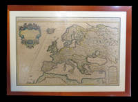
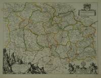
SANSON Nicolas
Les Suisses les Allies des Suisses et leurs Suiets; qui peuvent passer Sous le mon de Suisses. Partie de Souabe &c
Paris 1648. unbound. Map. Engraving with hand outline color. Image measures 14.5 x 21.5 inches.<br/><br/> This map of Switzerland centers on Lucerne covering approximately the area from Lake Constance south to Lake Como in Italy. Published in 1648 the map dates to the period of the Old Swiss Confederacy. Furthermore it predates by only a few years the Swiss Peasant War of 1653 a siege of Lucerne and Bern that demonstrated the significance of the rural population to the confederacy%u2019s stability. Hand-colored outlines on the map indicate the various independent states that made up the confederacy. A title cartouche with elaborate scrollwork adorns the lower right corner of the map. The map is in good condition with full margins and no chips or tears. Wear to lower margin. Nicolas Sanson 1600-1667 is considered the founder of the French school of cartography. In reaction to the prevailing trend of Dutch lavishness Sanson favored minimal details focusing rather on accurate cartography than ornament. This map demonstrates the skill that made him such a valuable asset to the French monarchy.<br/><br/> unknown books
书商的参考编号 : 251162

|
|
|
SANSON Nicolas
Paphlagonia Heroicis Temporibus Henetorum Populorum sede Clara; cujus Paphlagonia Maritima suit Romanorum Aetate Ponti Regni Pars Occidentalior In qua Sinope.
Amsterdam: Mortier Pieter. unbound. very good. Map. Engraving with original hand outline. Image measures 14.5" x 18.75".<br/><br/> Beautiful and rare map of northern Anatolia in Turkey circa 1708. Detailed and animated cartouche. Paphlagonia is the ancient area along the southern coast of the Black Sea. Full original margins light scattered foxing. Based on earlier plates by Nicolas Sanson 1600-1667 who is considered the founder of the French school of cartography. In reaction to the prevailing trend of Dutch lavishness Sanson favored minimal details focusing rather on accurate cartography than ornament.<br/><br/> Mortier, Pieter unknown books
书商的参考编号 : 215454

|
|
|
SANSON Nicolas
Partie de Barbarie ou Sontles Royaumes de Tunis et Tripoli
Paris 1683. unbound. Map. Copper engraving with hand coloring. Image measures 7 5/8 x 11 1/4 inches.<br/><br/> This map published in Paris in Afrique en plusieurs cartes is one of Sanson's small atlas maps of depicting various African regions. This map offers extensive detail on the cities of North Africa as well as topographical and geographical features with mountains beautifully rendered in profile. Nicolas Sanson 1600-1667 is considered the founder of the French school of cartography. In reaction to the prevailing trend of Dutch lavishness Sanson favored minimal details focusing rather on accurate cartography than ornament. This map is a fine example of his work.<br/><br/> unknown books
书商的参考编号 : 297468

|
|
|
Sanson Ronald
O PODER DO AMOR: A SOLU��O PARA TUDO EST� EM VOC� Portuguese Edition
NEW. unknown
书商的参考编号 : BIB-NOV-15-2025-133707 ???????? : 9798792761499 9798792761

|
|
|
Sanson & Mortier
Le Gouvernement Général de Languedoc. Partie Occidentale. antique map of Languedoc
Amsterdam: Pierre Mortier 1742. A BEAUTIFUL HAND-COLORED MAP OF WESTERN LANGUEDOC and areas to the west and north. 60 x 45.5 cm plate 62 x 52 cm sheet. The areas described in the title are FULLY COLORED BY A CONTEMPORARY HAND. Printed on fine thick laid paper. Reverse blank. A fine impression. A PRISTINE EXAMPLE with the paper FINE AND BRIGHT. Very scarce in such fine condition. <br/><br/> Pierre Mortier unknown
书商的参考编号 : 38209
|
|
|
SANSON (Andre).
Les moutons. Histoire naturelle et zootechnie. Quatrième édition. Ouvrage orné de 56 gravures.
Paris Librairie agricole de la maison rustique 1885. VI. 168 pages. 48 pages. 12x185cm. Broché. Non rogné. Couverture imprimée. Couverture cassée. Manques. Mouillures. Salissures. Manques et déchirures au dos. Pages de texte en bon état. Paris, Librairie agricole de la maison rustique, 1885. unknown
书商的参考编号 : 101808

|
|
|
SANSON (J.).
La prévision du temps en agriculture. Avec 60 figures intercallées dans le texte. Encyclopédie agricole publiée par une réunion d'Ingénieurs agronomes sous la direction de G. Wery.
Paris Baillière et fils 1925. 320 pages. 185x12cm. Broché. Non coupé. Couverture imprimée éditeur. Accidents aux coiffes. Légères taches sur les plats. Intérieur bruni. Très bon état. Paris, Baillière et fils, 1925. unknown
书商的参考编号 : 105549

|
|
|
SANSON (J.)
Mémorial de la Météorologie Nationale. Recueil de données statistiques relatives à la climatologie de la France
Couverture rigide. Bon/1953. in-folio. Paris 1953 in-folio pet. XI 1bl 148pp 1 carte toile bleutée. Rel. de l'ép. Grande carte dépliante h.t. en couleur logée à l'intérieur du second plat représentant les précipitations annuelles de 1891 à 1930. Cachets gras d'une ancienne bibliothèque unknown
书商的参考编号 : 8874
|
|
|
SANSON (Nicolas).
Carte gÂŽographique : Provinces-Unies des Pays-Bas sÂavoir sic Le DuchÂŽ de Gueldre les ComtÂŽs de Hollande Zeelande ZÂŽlande Zutphen Les Seigneureries d'Utrecht Over-Issel Groningue et Ouest-Frise avec leurs acquisitions dans la Flandre le Brabant le Limbourg et le LyÂge LiÂge et les places qu'elles possÂŽdaient sur le Rhein Rhin dans le DuchÂŽ de ClÂves et dans l'ArchevÂchÂŽ et Electorat de Cologne.
1690. S.l. Alexis Hubert Jaillot 1680. Une grande carte 892 x 592 mm composÂŽe de deux feuillets contrecollÂŽs sous cadre moderne. Attractive 892 x 592 mm carte de la fin du XVIIÂme avec rehauts aquarellÂŽs du temps. Elle s'orne d'un important cartouche aux armes du Grand Dauphin Louis de France et s'agrÂŽmente en marge gauche de la figuration de vaisseaux ayant pris part ˆ un combat naval. Kupcik Cartes gÂŽographiques anciennes p. 159. Papier trÂs lÂŽgÂrement oxydÂŽ. PrÂŽsence de rares et claires rousseurs ou petites t‰ches. Deux plissures et une infime perforation en marge supÂŽrieure droite. Du reste belle condition. b42961 unknown
书商的参考编号 : 19294
|
|
|
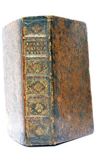
SANSON (Nicolas).
In Pharum Galliae Antiquae Philippi Labbe Biturici et Societatis Jesu Sacerdotis Disquisitiones Geographicae in quibus ad singula omnium locorum nomina aut Furti sive Plagii aut Falsii sive Erroris arguitur Philip. Labbe. Lutetiae Parisiorum sumptibus et impensis Autoris 1647. RELIÉ AVEC à la suite: 2. DU MEME. In Pharum Galliae Antiquae Philippi Labbe Biturici et Societatis Jesu Sacerdotis Disquisitiones Geographicae in quibus ad singula omnium locorum nomina aut Furti sive Plagii aut Falsii sive Erroris arguitur Philip. Labbe. Liber Secundus. Lutetiae Parisiorum sumptibus et impensis Autoris 1647. RELIÉ AVEC à la suite: 3. DU MEME. Index Géographicus et Explicatio Regionum et Locorum omnium in Tabulae Iudae descriptionum.S.l. 1653 A la fin Paris Carolus Savreux 1653.
Paris Lutetiae Parisiorum Sumptibus et Impensis Autoris 1647. 3 ouvrages en 1 volume. 1. 2 feuillets blancs. 8 feuillets. 246 pages. 2. 13 feuillets. 283 pages. 3. 2 feuillets blancs. Page de titre. Carte gravée. 11 feuillets. 2 feuillets blancs. 15x9 Cm. Plein veau de l'époque. Dos à nerfs orné et doré un peu frotté. Pièce de titre doré. Charnières fendues. Petits accidents aux coiffes. Rousseurs et quelques taches. Les deux premiers ouvrages sont des critiques très rares du "Pharum Gallia Antiquae" de Philippe Labbé que Sanson rectifie sur plusieurs points. À la suite on trouve une courte description de la Judée accompagnée d'une belle carte dépliante. Bon exemplaire comportant l'exlibris gravé d'Henri Liébaux. Paris, Lutetiae Parisiorum Sumptibus et Impensis Autoris, 1647. unknown
书商的参考编号 : 48297
|
|
|
Sanson (P.).
Douleur Maîtresse de Vie.
Paris, Flammarion, 1937. Une plaquette de format in 8° de 48 pp. bon état. Peu courant.
|
|
|
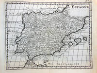
SANSON (Posiblemente)
Antiguo Grabado Mapa - Old Engraving Map : ESPAGNE
1738. Buen estado. Paris 1 lámina 13x16 cm márgenes sin enmarcar unknown
书商的参考编号 : 147571
|
|
|
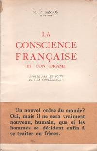
SANSON (R. P.)
La conscience française et son drame.
Editions Desclée de Brouwer 1941. Paperback. <b>Livre en français</b>. Couverture souple. Publié par les soins de ""la Conférence"". Broché. 54 pages. Avec son bandeau de librairie. <i>ref. 129826</i> Editions Desclée, de Brouwer paperback
书商的参考编号 : 129826
|
|
|
SANSON (R. P.).
La Souffrance et nous.
Paris Flammarion 1933. 223 pages. 1 feuillet. 19x12 Cm. roché. Couverture imprimée. Rousseurs. Accrocs. Mouillures. Plis. Écrit en 1933 ce livre invite à une profonde méditation sur la souffrance phénomène universel et intemporel qui touche l'existence humaine sous des formes multiples. À travers ce texte il explore les dimensions psychologiques morales et surtout spirituelles de la souffrance offrant au lecteur une approche éclairée par une foi ancrée probablement catholique qui cherche à transcender la douleur en un chemin de sens et d'espérance. Cette œuvre accessible et chaleureuse mêle philosophie et spiritualité sans éluder la réalité crue des souffrances humaines rendant le sujet à la fois proche et universel. Exemplaire usé. Importante mouillure dans la dernère partie du livre. Paris, Flammarion, 1933. unknown
书商的参考编号 : 119926
|
|
|
Sanson - Pol Andre
Mémoires de Sanson Exécuteur des Jugements Criminels
Couverture rigide. Bon/sd. in-8. Paris sd in-8 390pp broché Quelques défauts mineurs sinon très bel exemplaire! unknown
书商的参考编号 : 34930
|
|
|
Sanson - Vaugondy
L'Italieet ses Isles circonvoisines Sicile Sardaigne Corse & exactement divisees en leurs Etats Royaumes Republiques
Paris: Delamarche 1778. Very Good. Size : 515x685 mm 20.25x27 Inches Coloring: Original Outline Coloring Category: ; Maps Europe Italy Delamarche unknown
书商的参考编号 : M3888
|
|
|
SANSON [D'ABBEVILLE, Nicolas].
Anciens Royaumes De Kent D'Essex et De Sussex ou sont Aujourdhuy les Comtés Kent D'Essex Middlessex Et Hartford De Sussex Et Surrey. Avecq le Pas De Calais et Partie des Costes du Pays Bas de Picardie et Normandie.
Paris: Sanson. 1654. 36.6 x 48 cm. Original outline colour. Double page map of the south east England shown with the adjacent coastline of France and Belgium. Title cartouche to lower right corner. Blank on verso. Wear to centrefold with some small holes. Paris: (Sanson). 1654 unknown
书商的参考编号 : 28812
|
|
|
Sanson AJ
Les Vrais Principes De La Navigation Aerienne Ou L'enigme De L'annee 1839 D'evoilee;
Paris: Chez L'un des Auteurs et Chez Ledoyen Libraire 1852. 1st. Very Good. 1st edition. Pamphlet in original wraps bound in limp paper covered boards. A beautiful copy. <br/><br/> Chez L'un des Auteurs et Chez Ledoyen Libraire hardcover books
书商的参考编号 : 8000
|
|
|
Sanson Carrasco
Colección de ArtÃculos: Con una Introducción Classic Reprint
hardcover. Good. Access codes and supplements are not guaranteed with used items. May be an ex-library book. hardcover
书商的参考编号 : 0331540630.G ???????? : 0331540630 9780331540635
|
|
|
Sanson Christiane
MARIE DE LA TRINITÉ
CERF 2003. in8. 2003. Broché. CERF unknown
书商的参考编号 : 100143134
|
|
|
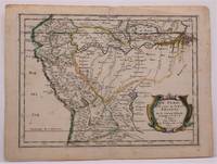
Sanson d"Abbeville, Nicolas
LE PEROU ET LE COURS DE LA RIVRE AMAZONE
Paris: Chez Sanson 1657. Image is 8 1/8 inches by 11 inches on a folded sheet measuring 9 inches by 12 13/16 inches. Original hand-colored copper-engraved map from Sanson's atlas of maps of the Americas: L'Amerique en Plusieurs Cartes. It is a map of the Viceroyalty of Peru that displays the Amazon River and its many tributaries. Nicolas Sanson 1600-1667 was the official geographer for the king of France. His map of Peru and the Amazon became the standard that was copied by almost all geographers/cartographers--even reproduced by Bion for his 1700 treatise on globes. Cintra and Oliveira argue that Sanson's map was a scientific one that holds up well even when compared to 21st century maps of the region. The map is in about very good condition: clean with bright original outline color; minimal foxing ; some edgewear and soiling in the margins. . First Edition. Single Sheet. Very Good-. 8 1/8 inches by 11 Inches. Map. Chez Sanson
书商的参考编号 : W2347
|
|
|
Sanson d'Abbeville Nicolas
"Partie de la Barbarie ou est le Royaume d'Alger divise en les Provinces. Parie du Biledulgerid." Map of Northern Africa. Attractive and detailed coastal map of North Africa with Algeria. Antique Engraved Hand-Coloured Map.
Paris Sanson d'Abbeville Nicolas Ca 1660. In ivory mount. Mount size 16 x 13.5 inches 40.5cm x 35cm Engraved size 28cm x 22cm 11 x 8.5 inches In very good condition. Laid Down. Paris Sanson d'Abbeville, Nicolas Ca 1660 unknown
书商的参考编号 : 92217
|
|
|
Sanson D'abbeville / Pauline Carson Bloch & Robert Martinon (Trans.) / Louis M. Bloch, Jr. (Ed.)
America 1667. Volume I. A Translation Of " L'amerique" Written In 1667 By Sanson D'abbeville Geographer And Teacher Of King Louis Xiv Of France Review Copy
Cleveland Oh: Bloch And Company 1959. 1st Edition 1st Printing. Hardcover. Very Good. Color Maps. 64 Pp. Blue Cloth Gilt. First Printing. Near Fine; Dust Jacket Slightly Worn; 1/2" X 1" Tape Residues Where Dust Jacket Was Formerly Neatly Attached To Front And Rear Endpapers. Review Copy With January 1959 Review Letter From Bloch & Co. <br/> <br/> Bloch And Company hardcover
书商的参考编号 : 053400
|
|
|
Sanson d'Abbeville, Nicholas
Brazil Brasil waar van de Kust door de Portugeezen bezeten .
Americas: Amsterdam Francois Halma 1705. Copper engraved map of Brazil by N. Sanson from Halma's Algemeene Werelde Beschryving Vol. 3 Black and white; title in Dutch; verso blank; Attractive small map of Brazil; title cartouche surrounded by garland of leaves in centre of country. This map appeared in Algemeene Weereld-Beschryving nae de Rechte Verdeeling der Landschappen Plaetsen Zeeën Rivieren &c. Geographisch Politisch Historisch Chronologisch en Genealogisch a Dutch edition of A. Phérotée de la Croix's Nouvelle Methode Pour Apprendre Facilement la Geographie Universelle which first appeared in 1690. Dark impression; minor dampstain at top of centre fold. Nicolas Sanson d'Abbeville.1600-67 ' father of the French cartography' and founder of the Sanson firm. Atlas ' Cartes générales de toutes les parties du Monde' 1658-70 and a pocket atlas in 4 parts 1652-1705. Sanson's small maps from A. Phérotée de la Croix's Nouvelle Methode Pour Apprendre Facilement la Geographie Universelle. first published in 1652 and engraved by A. Peyrounin were copied several times by various map publishers. Johann David Zunners made copies of Sanson's maps for his German translation of Die Gantze Erd-Kugel in 1679. Johannes Ribbius and Simon de Vries published copies in 1682 and 1683 with new maps engraved by Antoine d'Winter. The plates were later sold to Francois Halma who used them in 1699 and then again in 1705 with the titles re-engraved in Dutch. François Halma 1653 - 1722 Dutch publisher/printer; dealer/auction house. Cartographer and publisher of maps active in Utrecht Amsterdam Franeker and Leeuwarden. Published 'Description de l'Univers' 1700; 'Algemene Wereldtbescrijving' 1705; 'Corpus Inscriptionum' 1707 and 'Lexicon Philosophicum' 1713. Keoman: Hal 1; Phillips 528. Americas South America Brazil Amsterdam Francois Halma 1705 unknown
书商的参考编号 : 3249
|
|
|
Sanson d'Abbeville, Nicholas
Canada of New France. Canada of Niew Vrankryk. Getrokken uit verschiede Franche Engelsche en en Hollandsche Beschrivingern enz. .
Americas: Amsterdam Francois Halma 1705. Copper engraved map of Canada by N. Sanson from Halma's Algemeene Werelde Beschryving Vol. 3 Black and white; title in Dutch; verso blank; strapwork title cartouche. Attractive small map of Canada and the Great Lakes a reduced version of one of the most influential seventeenth century maps of the French and English colonies in North America. It concentrates on the region of greatest French interest. The entire Great Lakes basin and the St. Lawrence River are shown in great detail. The most important aspect of the map is the first appearance of L. Erie ou du Chat as a recognizable lake on an atlas map. This delineation influenced the cartography of the region for more than 100 years and was not superceded until Delisle's "Carte du Canada" in 1703. The map is also an outstanding source for Indian tribal names and locations. Two names:Aouentsiouaeron and Attiouandarons appear here for the first time. Lake Superior and Michigan Lac du Puans are left open-end to the west. Embellished with a nice title cartouche and engraved by Anthoine d'Winter. This is the third state. Published in Francois Halma's Dutch edition of A. Pherotee de la Croix's Nouvelle Methode Pour Apprendre facilement la Geographie Universelle. Dark impression; dampstaining to lower margin just entering plate; centrefold and 2 further folds to fit in binding. Nicolas Sanson d'Abbeville.1600-67 ' father of the French cartography' and founder of the Sanson firm. Atlas ' Cartes générales de toutes les parties du Monde' 1658-70 and a pocket atlas in 4 parts 1652-1705. Sanson's small maps from A. Phérotée de la Croix's Nouvelle Methode Pour Apprendre Facilement la Geographie Universelle. first published in 1652 and engraved by A. Peyrounin were copied several times by various map publishers. Johann David Zunners made copies of Sanson's maps for his German translation of Die Gantze Erd-Kugel in 1679. Johannes Ribbius and Simon de Vries published copies in 1682 and 1683 with new maps engraved by Antoine d'Winter. The plates were later sold to Francois Halma who used them in 1699 and then again in 1705 with the titles re-engraved in Dutch. François Halma 1653 - 1722 Dutch publisher/printer; dealer/auction house. Cartographer and publisher of maps active in Utrecht Amsterdam Franeker and Leeuwarden. Published 'Description de l'Univers' 1700; 'Algemene Wereldtbescrijving' 1705; 'Corpus Inscriptionum' 1707 and 'Lexicon Philosophicum' 1713. Keoman: Hal 1; Phillips 528; Burden #575; Kershaw #138; McCorkle #683.5. Americas Canada Great Lakes New France Niew Vrankryk Amsterdam Francois Halma 1705 unknown
书商的参考编号 : 3239
|
|
|
Sanson d'Abbeville, Nicolas (1600-1667); Francois Chauveau, (1613-1676); R. Cordier d'Abbeville, engraver.
Carte generale du tres-haut tres-puissant et tres chrestien royaume de France et de tous les pays circom-voisins. Présentée a Sa Majesté Tres Chrest ien Louis XIIII / Par son tres humble tres obeissant et tres-fidele serviteur et suject N. Sanson d'Abbeville geographe ordinaire de sa Majesté . ;Gravé par R. Cordier d'Abbeville. First edition of the Atlas with 18 maps.
Paris: 1653. Folio. 30 x 43.2cm. Defective contemporary thick paper covers. Title page and dedication page with losses. Handcolored in outline. One map with loss in lower right corner and one map with tear in lower right corner Sixteen double page maps complete some with waterstains visible verso.Rare to find such a large ensemble of Sanson's maps. Reference: Bibliothèque nationale de France; ark:/12148/btv1b530780775/; Bibliothèque nationale de France département Cartes et plans GE A-592 RES . Paris: 1653. unknown
书商的参考编号 : 16-6140
|
|
|
Sanson d'Abbeville Nicholas
Chili. Chili Getrokken uit Alfonso de Oualle Jesuit en in Dertien Rechts-Gebieden Verdeelt.
Americas: Amsterdam Francois Halma 1705. Copper engraved map of Chili by N. Sanson from Halma's Algemeene Werelde Beschryving Vol. 3 Black and white; title in Dutch; verso blank; strapwork title cartouche. Small version of Sanson's important map of Chili showing the Cuyo provinces. The map is based on the descriptions of Alfonso de Ovalle. This map appeared in Algemeene Weereld-Beschryving nae de Rechte Verdeeling der Landschappen Plaetsen Zeeën Rivieren &c. Geographisch Politisch Historisch Chronologisch en Genealogisch a Dutch edition of A. Phérotée de la Croix's Nouvelle Methode Pour Apprendre Facilement la Geographie Universelle which first appeared in 1690. Dark impression. Nicolas Sanson d'Abbeville.1600-67 ' father of the French cartography' and founder of the Sanson firm. Atlas ' Cartes générales de toutes les parties du Monde' 1658-70 and a pocket atlas in 4 parts 1652-1705. Sanson's small maps from A. Phérotée de la Croix's Nouvelle Methode Pour Apprendre Facilement la Geographie Universelle. first published in 1652 and engraved by A. Peyrounin were copied several times by various map publishers. Johann David Zunners made copies of Sanson's maps for his German translation of Die Gantze Erd-Kugel in 1679. Johannes Ribbius and Simon de Vries published copies in 1682 and 1683 with new maps engraved by Antoine d'Winter. The plates were later sold to Francois Halma who used them in 1699 and then again in 1705 with the titles re-engraved in Dutch. François Halma 1653 - 1722 Dutch publisher/printer; dealer/auction house. Cartographer and publisher of maps active in Utrecht Amsterdam Franeker and Leeuwarden. Published 'Description de l'Univers' 1700; 'Algemene Wereldtbescrijving' 1705; 'Corpus Inscriptionum' 1707 and 'Lexicon Philosophicum' 1713. Keoman: Hal 1; Phillips 528. Americas South America Chili Amsterdam Francois Halma 1705 unknown
书商的参考编号 : 3251
|
|
|
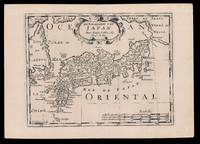
SANSON D'ABBEVILLE Nicolas I and HALMA Francois
De Eilanden van Japan
Amsterdam: Francois Halma 1705. 221 by 311mm. 8.75 by 12.25 inches. Engraved map. Third state of the plate first published in Halma's pirated edition of Sanson's 'L'Asie en plvsiers cartes nouvelles et exactes;…' as part of 'L'Europe; L'Asie; L'Amerique… en Pluiers Cartes' 1683. A direct copy of Sanson's map of 1652 the only differences being the lack of a privilege and a date in the cartouche the addition of the signature of the engraver Antoine de Winter in the lower left corner. This issue was published in Halma's Dutch edition 'Algemeene Wereldbeschryving…' in 1705 and is distinguished by the change of the title from French into Dutch. Francois Halma 1653-1722 set up his printing business in Utrecht in 1674 where he issued a number of pirated maps and atlases. In this instance since Sanson was dead Halma may have felt that there no harm and much profit to be gained from re-printing his work. The engraver Antoine de Winter c1652-1700 achieved some notoriety for plagiarizing Petter Gedda's charts of the Baltic Sea selling them on to Loots and Doncker for inclusion in their atlases who were subsequently sued and ordered to surrender the plates and pay a fine of 300 florins. Sanson originally credited "Caardin sic Varenius" and 'others' for his map. Generally the geography follows that of Moreira/Blancus only a small portion of the eastern coast of Korea is shown without stating whether it is an island or not and there is only a hint of Hokkaido in the far northeast corner with the place name Matzumay. Varenius or Bernhard Varen fl1622-1650 was a German physician geographer and natural historian. He settled in Amsterdam and was a friend of the Blaeu family. He published 'Descriptio regni Japonia…' in 1649 and came to be known as 'the father of physical geography' Hubbard. Sanson 1600-1667 was a French mapmaker. He supposedly began to make maps to supplement his study of history and a map of Ancient Gaul made early in his career brought him to the attention of Cardinal Richelieu. This foothold in the French court allowed him to rise to the position of Geographe du Roi teaching both Louis XIII and Louis XIV. Louis XIII even made him a counsellor of state. Sanson produced an atlas 'Cartes Generales de Toutes les Parties du Monde' which contained important maps of the post roads and waterways of France. He also produced two major maps of North America: 'Amerique Septentrionale' 1650 was the first map to show the Great Lakes in a recognisable form aided by Sanson's access to The Jesuit Relations a collection of accounts by French missionaries to the area. The map was also drawn on a sinusoidal projection which Sanson was the first to use. In 1656 he made 'Le Canada ou Nouvelle France' which showed the Great Lakes in greater detail and included accurate representations of the Hudson Bay area the Delaware and the Gulf of Saint Lawrence. After Sanson's death the business was carried on by his two surviving sons and grandson in partnership with Hubert Jaillot. Sanson family members were revered among the foremost map makers in France for nearly a century. A leading exemplar of the French school of seventeenth-century cartography Nicholas Sanson I is widely regarded as the founder of modern geography and it is generally held that the so called "Great Age" of French cartography originated with his publications. Hubbard 51.3. Francois Halma, unknown
书商的参考编号 : 15819
|
|
|
SANSON D'ABBEVILLE, N[icolas].
Diocese du Mans Divisee Par Doyennes Ruraux.
Paris: Pierre Mariette. c. 1658. 37.4 x 49.5 cm. Original outline colour. Double page map of Maine northern France. Title cartouche to lower left corner dedication cartouche to Christophe de Justel to upper right corner with the coat of arms of his family. Blank on verso. Small tears without loss to left and lower margins. Light stains to lower margin otherwise in good condition. Paris: Pierre Mariette. [c. 1658] unknown
书商的参考编号 : 28798
|
|
|
Sanson d'Abbeville, Nicholas
Florida. Florida zoo als het van de Spaanschen en Franschen wordt bezeten. .
Americas: Amsterdam Francois Halma 1705. Copper engraved map of Florida by N. Sanson from Halma's Algemeene Werelde Beschryving Vol. 3 Black and white; title in Dutch; verso blank; strapwork title cartouche. This influential map shows the Spanish and French possessions in the southern part of the United States. The map extends from the southernmost part of Virginia to the coast of what is now Texas. When first introduced by Sanson in 1657 this map was the first to use the name L. Erie in an atlas and to introduce several new rivers in Virginia. The French claims in the Carolinas are reasserted with the region named Floride Francoise despite the region not having had any French presence for nearly 100 years. The place name Caroline is not related to the future English colony of Carolina. Instead it is a confusion between the French Fort Caroline on the St. Johns River and Charlefort that was located near Port Royal. According to Burden this is the third state of the map. Published in Francois Halma's Dutch edition of A. Pherotee de la Croix's Nouvelle Methode Pour Apprendre facilement la Geographie Universelle. Dark impression; pin hole paper fault to upper right below latitude 40. Nicolas Sanson d'Abbeville.1600-67 ' father of the French cartography' and founder of the Sanson firm. Atlas ' Cartes générales de toutes les parties du Monde' 1658-70 and a pocket atlas in 4 parts 1652-1705. Sanson's small maps from A. Phérotée de la Croix's Nouvelle Methode Pour Apprendre Facilement la Geographie Universelle. first published in 1652 and engraved by A. Peyrounin were copied several times by various map publishers. Johann David Zunners made copies of Sanson's maps for his German translation of Die Gantze Erd-Kugel in 1679. Johannes Ribbius and Simon de Vries published copies in 1682 and 1683 with new maps engraved by Antoine d'Winter. The plates were later sold to Francois Halma who used them in 1699 and then again in 1705 with the titles re-engraved in Dutch. François Halma 1653 - 1722 Dutch publisher/printer; dealer/auction house. Cartographer and publisher of maps active in Utrecht Amsterdam Franeker and Leeuwarden. Published 'Description de l'Univers' 1700; 'Algemene Wereldtbescrijving' 1705; 'Corpus Inscriptionum' 1707 and 'Lexicon Philosophicum' 1713. Keoman: Hal 1; Phillips 528; Burden #546; Cumming SE #53. Americas Florida Amsterdam Francois Halma 1705 unknown
书商的参考编号 : 3240
|
|
|
Sanson d'Abbeville, Nicholas
Guatemala. Landstreek van Guatemala .
Americas: Amsterdam Francois Halma 1705. Copper engraved map of Guatemala by N. Sanson from Halma's Algemeene Werelde Beschryving Vol. 3 Black and white; title in Dutch; verso blank; strapwork title cartouche. This map appeared in Algemeene Weereld-Beschryving nae de Rechte Verdeeling der Landschappen Plaetsen Zeeën Rivieren &c. Geographisch Politisch Historisch Chronologisch en Genealogisch a Dutch edition of A. Phérotée de la Croix's Nouvelle Methode Pour Apprendre Facilement la Geographie Universelle which first appeared in 1690. Dark impression. Nicolas Sanson d'Abbeville.1600-67 ' father of the French cartography' and founder of the Sanson firm. Atlas ' Cartes générales de toutes les parties du Monde' 1658-70 and a pocket atlas in 4 parts 1652-1705. Sanson's small maps from A. Phérotée de la Croix's Nouvelle Methode Pour Apprendre Facilement la Geographie Universelle. first published in 1652 and engraved by A. Peyrounin were copied several times by various map publishers. Johann David Zunners made copies of Sanson's maps for his German translation of Die Gantze Erd-Kugel in 1679. Johannes Ribbius and Simon de Vries published copies in 1682 and 1683 with new maps engraved by Antoine d'Winter. The plates were later sold to Francois Halma who used them in 1699 and then again in 1705 with the titles re-engraved in Dutch. François Halma 1653 - 1722 Dutch publisher/printer; dealer/auction house. Cartographer and publisher of maps active in Utrecht Amsterdam Franeker and Leeuwarden. Published 'Description de l'Univers' 1700; 'Algemene Wereldtbescrijving' 1705; 'Corpus Inscriptionum' 1707 and 'Lexicon Philosophicum' 1713. Keoman: Hal 1; Phillips 528; B Americas Central America Guatemala Amsterdam Francois Halma 1705 unknown
书商的参考编号 : 3244
|
|
|
Sanson d'Abbeville, Nicholas
Guyana. Guiana verdeelt Guina en Caribana.
Americas: Amsterdam Francois Halma 1705. Copper engraved map of Guyana by N. Sanson from Halma's Algemeene Werelde Beschryving Vol. 3 Black and white; title in Dutch; verso blank; strapwork title cartouche. The map shows a large lake or inland sea Lac ou Mer que les Caribes appellent Parime les Iaoyi Roponowini. and located on its shores the mythical city of El Dorado or Manoa. Lake Parime or Lake Parima is a legendary lake located in South America. It was reputedly the location of the fabled city of El Dorado also known as Manoa much sought-after by European explorers. Repeated attempts to find the lake failed to confirm its existence and it was dismissed as a myth along with the city. The search for Lake Parime led explorers to map the rivers and other features of southern Venezuela northern Brazil and southwestern Guyana before the lake's existence was definitively disproved in the early 19th century. Some explorers proposed that the seasonal flooding of the Rupununi savannah may have been misidentified as a lake. Recent geological investigations suggest that a lake may have existed in northern Brazil but that it dried up some time in the 18th century. Both "Manoa" Arawak language and "Parime" Carib language are believed to mean "big lake". This map appeared in Algemeene Weereld-Beschryving nae de Rechte Verdeeling der Landschappen Plaetsen Zeeën Rivieren &c. Geographisch Politisch Historisch Chronologisch en Genealogisch a Dutch edition of A. Phérotée de la Croix's Nouvelle Methode Pour Apprendre Facilement la Geographie Universelle which first appeared in 1690. Dark impression. Nicolas Sanson d'Abbeville.1600-67 ' father of the French cartography' and founder of the Sanson firm. Atlas ' Cartes générales de toutes les parties du Monde' 1658-70 and a pocket atlas in 4 parts 1652-1705. Sanson's small maps from A. Phérotée de la Croix's Nouvelle Methode Pour Apprendre Facilement la Geographie Universelle. first published in 1652 and engraved by A. Peyrounin were copied several times by various map publishers. Johann David Zunners made copies of Sanson's maps for his German translation of Die Gantze Erd-Kugel in 1679. Johannes Ribbius and Simon de Vries published copies in 1682 and 1683 with new maps engraved by Antoine d'Winter. The plates were later sold to Francois Halma who used them in 1699 and then again in 1705 with the titles re-engraved in Dutch. François Halma 1653 - 1722 Dutch publisher/printer; dealer/auction house. Cartographer and publisher of maps active in Utrecht Amsterdam Franeker and Leeuwarden. Published 'Description de l'Univers' 1700; 'Algemene Wereldtbescrijving' 1705; 'Corpus Inscriptionum' 1707 and 'Lexicon Philosophicum' 1713. Keoman: Hal 1; Phillips 528. Americas South America Guyana Guiana Amsterdam Francois Halma 1705 unknown
书商的参考编号 : 3247
|
|
|
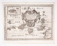
SANSON D'ABBEVILLE, Guillaume.
Isles Canaries
c.1700. Original engraved map 19 x26.5 cm. overall sheet size 22 x 29 cm. of the Canaries with inset of Madeira. Central vertical fold. [c.1700] unknown
书商的参考编号 : 53608
|
|
|
Sanson d'Abbeville, S.
L'Asie en plusieurs cartes nouvelles et exactes &c. en divers traités de geographie et d'histoire. Là où sont descrits succinctement & avec une belle methode & facile. Ses empires ses monarchies ses estats &c. .
Paris: Chez L'autheur 1662. Book. Good. Full-Leather. 4to - over 9¾" - 12" tall. 104 pages. Text only lacking all maps. Sound leather binding a little war at the top of the spine. No publication date assumed 1662. Chez L'autheur Hardcover
书商的参考编号 : 6235
|
|
|
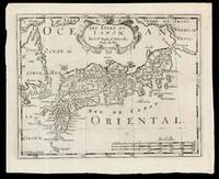
SANSON D'ABBEVILLE, Nicolas (I) and HALMA, Francois
Les Isles dv Iapon
Amsterdam: Chez Arnout van Ravenstein 1699. 222 by 272mm. 8.75 by 10.75 inches. Engraved map. Second state of the plate first published in Halma's pirated edition of Sanson's 'L'Asie en plvsiers cartes nouvelles et exactes;…' as part of 'L'Europe; L'Asie; L'Amerique… en Pluiers Cartes' 1683. A direct copy of Sanson's map of 1652 the only differences being the lack of a privilege and a date in the cartouche the addition of the signature of the engraver Antoine de Winter in the lower left corner. This issue is distinguished by the addition of mountains added in 'Isle de Corey' and 'Terre de Iesso'; and the 'Mer de Japan' above 'Oriental'. Francois Halma 1653-1722 set up his printing business in Utrecht in 1674 where he issued a number of pirated maps and atlases. In this instance since Sanson was dead Halma may have felt that there no harm and much profit to be gained from re-printing his work. The engraver Antoine de Winter c1652-1700 achieved some notoriety for plagiarizing Petter Gedda's charts of the Baltic Sea selling them on to Loots and Doncker for inclusion in their atlases who were subsequently sued and ordered to surrender the plates and pay a fine of 300 florins. Sanson originally credited "Caardin sic Varenius" and 'others' for his map. Generally the geography follows that of Moreira/Blancus only a small portion of the eastern coast of Korea is shown without stating whether it is an island or not and there is only a hint of Hokkaido in the far northeast corner with the place name Matzumay. Varenius or Bernhard Varen fl1622-1650 was a German physician geographer and natural historian. He settled in Amsterdam and was a friend of the Blaeu family. He published 'Descriptio regni Japonia…' in 1649 and came to be known as 'the father of physical geography' Hubbard. Sanson 1600-1667 was a French mapmaker. He supposedly began to make maps to supplement his study of history and a map of Ancient Gaul made early in his career brought him to the attention of Cardinal Richelieu. This foothold in the French court allowed him to rise to the position of Geographe du Roi teaching both Louis XIII and Louis XIV. Louis XIII even made him a counsellor of state. Sanson produced an atlas 'Cartes Generales de Toutes les Parties du Monde' which contained important maps of the post roads and waterways of France. He also produced two major maps of North America: 'Amerique Septentrionale' 1650 was the first map to show the Great Lakes in a recognisable form aided by Sanson's access to The Jesuit Relations a collection of accounts by French missionaries to the area. The map was also drawn on a sinusoidal projection which Sanson was the first to use. In 1656 he made 'Le Canada ou Nouvelle France' which showed the Great Lakes in greater detail and included accurate representations of the Hudson Bay area the Delaware and the Gulf of Saint Lawrence. After Sanson's death the business was carried on by his two surviving sons and grandson in partnership with Hubert Jaillot. Sanson family members were revered among the foremost map makers in France for nearly a century. A leading exemplar of the French school of seventeenth-century cartography Nicholas Sanson I is widely regarded as the founder of modern geography and it is generally held that the so called "Great Age" of French cartography originated with his publications Hubbard 51.2. Chez Arnout van Ravenstein, unknown
书商的参考编号 : 15831
|
|
|
SANSON D'ABBELVILLE, Nicolas
L’Asie en plussieurs cartes nouvelles et exactes: & en divers traitses de geographie et d’histoire
Paris: chez l’Autheur 1662. SECOND EDITION. Complete with 17 double-page engraved maps hand-colored in outline. Contemporary mottled calf corner edges neatly repaired interior has some minor dampstaining mainly on text and on blank verso of maps last blank leaf torn on lower fore-edge. A contemporary signature on first blank leaf. Similar to L’Amerique this atlas of the continent of Asia was first printed in 1652 and reprinted here with a new title page. The maps are all dated 1652 with only one dated 1653 and do not include the address of Mariette. The atlas features maps of India Persia China Japan the Maldives Arabia and the Philippines among others. <br /> <br /> Just prior to publication of this series of works which also included atlases of Europe and Africa Sanson formed a partnership with Pierre Mariette an engraver and printseller. Pursuant to their contract Sanson drew the maps and Mariette engraved and printed them. Each maintained possession of half of the plates and they were allowed to exchange and/or buy from one another. Some bore the address of Sanson others Mariette. But Sanson allowed Mariette to store his plates and Mariette without prior agreement started placing his address on Sanson’s plates. In time a lawsuit which had been prosecuted was settled when both died and their respective sons took over the business.<br /> <br /> This atlas is a fine examples of French mapping by the foremost French cartographer of the seventeenth century. Sanson 1600-1667 “Geographe Ordinaire du Roi†to Louis XIII is considered the founder of French cartography and is generally acknowledged as the originator of the great age of French cartography. chez l’Autheur unknown
书商的参考编号 : 16493
|
|
|
Sanson d'Abbeville, Nicholas
Magellanica. De Straat van Magellanes met het Magellanisch Landt en d'Eilanden.
Americas: Amsterdam Francois Halma 1705. Copper engraved map of Peru by N. Sanson from Halma's Algemeene Werelde Beschryving Vol. 3 Black and white; title in Dutch; verso blank; strapwork title cartouche. Small map of Tierra del Fuego showing both the Strait of Magellan and Le Maire Strait. Inland detail is confined to a mountain range and several rivers and the mythical Destroit de Browers is labeled at far right. This map appeared in Algemeene Weereld-Beschryving nae de Rechte Verdeeling der Landschappen Plaetsen Zeeën Rivieren &c. Geographisch Politisch Historisch Chronologisch en Genealogisch a Dutch edition of A. Phérotée de la Croix's Nouvelle Methode Pour Apprendre Facilement la Geographie Universelle which first appeared in 1690. Dark impression. Nicolas Sanson d'Abbeville.1600-67 ' father of the French cartography' and founder of the Sanson firm. Atlas ' Cartes générales de toutes les parties du Monde' 1658-70 and a pocket atlas in 4 parts 1652-1705. Sanson's small maps from A. Phérotée de la Croix's Nouvelle Methode Pour Apprendre Facilement la Geographie Universelle. first published in 1652 and engraved by A. Peyrounin were copied several times by various map publishers. Johann David Zunners made copies of Sanson's maps for his German translation of Die Gantze Erd-Kugel in 1679. Johannes Ribbius and Simon de Vries published copies in 1682 and 1683 with new maps engraved by Antoine d'Winter. The plates were later sold to Francois Halma who used them in 1699 and then again in 1705 with the titles re-engraved in Dutch. François Halma 1653 - 1722 Dutch publisher/printer; dealer/auction house. Cartographer and publisher of maps active in Utrecht Amsterdam Franeker and Leeuwarden. Published 'Description de l'Univers' 1700; 'Algemene Wereldtbescrijving' 1705; 'Corpus Inscriptionum' 1707 and 'Lexicon Philosophicum' 1713. Halma acquired many of the plates for Algemeene Weereld-Beschryving from Joannes Ribbius who had enlisted the services of engraver Antoine de Winter to make copies of the maps in Nicolas Sanson's quarto atlases of the four continents. De Winter made very few geographical changes and maintained the attribution to Sanson on the newly engraved plates. Halma supplemented the Sanson maps with about a dozen new maps engraved in the same style as Sanson's without any attribution on the maps as well as 23 panoramic views of famous cities around the world. Keoman: Hal 1; Phillips 528. Americas South America Tierra del Fuego Magellanica Strait of Magellan Amsterdam Francois Halma 1705 unknown
书商的参考编号 : 3253
|
|
|
SANSON D'ABBEVILLE, SOMMER (Sculpsit)
Mapa Antiguo - Old Map : LES ESTATS DE LA COURONNE DE CASTILLE Dasn les Parties plus Meridionales de l'Espagne et la ou font Castille Nouvelle Andalousie Grenade et Murcie
1652. Buen estado sin margen parte superior. Editorial: Chez Pierre Mariette Paris 1 lámina 405x535 cm mapa Sin enmarcar Par le Sr Sanson d'Abbeville Geographe du Roy a Paris. Coloreado a mano. unknown
书商的参考编号 : 147629
|
|
|
SANSON D'ABBEVILLE Geographe du Roy 1600 1667
Mapa Antiguo - Old Map : LES ESTATS DE LA COURONNE DE CASTILLE Dans les Parties plus Septentrionales de L'Espagne et la ou sont Les Royaumes de Castille Vielle Leon Gallice Asturie Biscaie Seign.rie Navarre.
1652. Buen estado. Edición Pierre Mariette Paris 1 lámina 55 x 42 cm mapa 7 cm paspartú por cada lado Enmarcado con paspartú Coloreado a mano unknown
书商的参考编号 : 147610
|
|
|
SANSON D'ABBEVILLE SOMMER Sculpsit
Mapa Antiguo - Old Map : ROYAUME DE NAVARRE Divisé en Sis Merindades.
1652. Buen estado. Editorial: Chez Pierre Mariette Paris 1 lámina 42x57 cm mapa márgenes Sin enmarcar Par le Sr Sanson d'Abbeville Geographe du Roy a Paris. Coloreado a mano. unknown
书商的参考编号 : 147630
|
|
|
Sanson d'Abbeville Nicholas
Mexico. T Gebiedt van Mexico.
Americas: Amsterdam Francois Halma 1705. Copper engraved map of Mexico by N. Sanson from Halma's Algemeene Werelde Beschryving Vol. 3 Black and white; title in Dutch; verso blank; strapwork title cartouche. The map shows Mexico including the Yucatan peninsula part of present-day Guatemala and Honduras. This map appeared in Algemeene Weereld-Beschryving nae de Rechte Verdeeling der Landschappen Plaetsen Zeeën Rivieren &c. Geographisch Politisch Historisch Chronologisch en Genealogisch a Dutch edition of A. Phérotée de la Croix's Nouvelle Methode Pour Apprendre Facilement la Geographie Universelle which first appeared in 1690. Dark impression. Nicolas Sanson d'Abbeville.1600-67 ' father of the French cartography' and founder of the Sanson firm. Atlas ' Cartes générales de toutes les parties du Monde' 1658-70 and a pocket atlas in 4 parts 1652-1705. Sanson's small maps from A. Phérotée de la Croix's Nouvelle Methode Pour Apprendre Facilement la Geographie Universelle. first published in 1652 and engraved by A. Peyrounin were copied several times by various map publishers. Johann David Zunners made copies of Sanson's maps for his German translation of Die Gantze Erd-Kugel in 1679. Johannes Ribbius and Simon de Vries published copies in 1682 and 1683 with new maps engraved by Antoine d'Winter. The plates were later sold to Francois Halma who used them in 1699 and then again in 1705 with the titles re-engraved in Dutch. François Halma 1653 - 1722 Dutch publisher/printer; dealer/auction house. Cartographer and publisher of maps active in Utrecht Amsterdam Franeker and Leeuwarden. Published 'Description de l'Univers' 1700; 'Algemene Wereldtbescrijving' 1705; 'Corpus Inscriptionum' 1707 and 'Lexicon Philosophicum' 1713. Keoman: Hal 1; Phillips 528; B Americas Mexico Yucatan Guatemala Honduras Amsterdam Francois Halma 1705 unknown
书商的参考编号 : 3243
|
|
|
Sanson d'Abbeville, Nicholas
North America. Noorder America.
Americas: Amsterdam Francois Halma 1705. Copper engraved map of North America by N. Sanson from Halma's Algemeene Werelde Beschryving Vol. 3 Black and white; title in Dutch; verso blank; strapwork title cartouche. Attractive small map showing North America with California as an Island California is shown with an indented northern coastline in the Foxe form. The detached coastline to the northwest of California is named Terre de Iesso ou Ieco rather than reflecting Sanson's earlier belief that it was an extension of the American continent. The R. de Nort drains into the Gulf of California from a large interior lake in the country of Les Apaches. The two western-most Great Lakes are left open-ended and Lake Erie remains unnamed. Engraved by Antoine d'Winter. This is the third state which includes a peninsula inserted northeast of California the Carolinas attributed to the French N. Iork added below N. Amstredam and an umlaut over the "Roy" in the title. This map appeared in Algemeene Weereld-Beschryving nae de Rechte Verdeeling der Landschappen Plaetsen Zeeën Rivieren &c. Geographisch Politisch Historisch Chronologisch en Genealogisch a Dutch edition of A. Phérotée de la Croix's Nouvelle Methode Pour Apprendre Facilement la Geographie Universelle which first appeared in 1690. Dark impression; dampstaining to edges not entering image. Nicolas Sanson d'Abbeville.1600-67 ' father of the French cartography' and founder of the Sanson firm. Atlas ' Cartes générales de toutes les parties du Monde' 1658-70 and a pocket atlas in 4 parts 1652-1705. Sanson's small maps from A. Phérotée de la Croix's Nouvelle Methode Pour Apprendre Facilement la Geographie Universelle. first published in 1652 and engraved by A. Peyrounin were copied several times by various map publishers. Johann David Zunners made copies of Sanson's maps for his German translation of Die Gantze Erd-Kugel in 1679. Johannes Ribbius and Simon de Vries published copies in 1682 and 1683 with new maps engraved by Antoine d'Winter. The plates were later sold to Francois Halma who used them in 1699 and then again in 1705 with the titles re-engraved in Dutch. François Halma 1653 - 1722 Dutch publisher/printer; dealer/auction house. Cartographer and publisher of maps active in Utrecht Amsterdam Franeker and Leeuwarden. Published 'Description de l'Univers' 1700; 'Algemene Wereldtbescrijving' 1705; 'Corpus Inscriptionum' 1707 and 'Lexicon Philosophicum' 1713. Keoman: Hal 1; Phillips 528; Burden #545; McLaughlin #89-3. Americas North America California as Island Amsterdam Francois Halma 1705 unknown
书商的参考编号 : 3238
|
|
|
Sanson d'Abbeville, Nicholas
Paraguay. Paraguay Verdeelt in zyn Voornaamste Deelen Volgens de Laatste Reisbeschryvinge .
Americas: Amsterdam Francois Halma 1705. Copper engraved map of Paraguayby N. Sanson from Halma's Algemeene Werelde Beschryving Vol. 3 Black and white; title in Dutch; verso blank; strapwork title cartouche. The map shows the region of present day Paraguay Uruguay northern Argentina and southern Brazil. The Rio de la Plata is the main feature of the map along with the mountains and volcanoes of the Cordillera de los Andes. Engraved by Antoine de Winter. This map appeared in Algemeene Weereld-Beschryving nae de Rechte Verdeeling der Landschappen Plaetsen Zeeën Rivieren &c. Geographisch Politisch Historisch Chronologisch en Genealogisch a Dutch edition of A. Phérotée de la Croix's Nouvelle Methode Pour Apprendre Facilement la Geographie Universelle which first appeared in 1690. Dark impression; minor dampstain at top of centre fold. Nicolas Sanson d'Abbeville.1600-67 ' father of the French cartography' and founder of the Sanson firm. Atlas ' Cartes générales de toutes les parties du Monde' 1658-70 and a pocket atlas in 4 parts 1652-1705. Sanson's small maps from A. Phérotée de la Croix's Nouvelle Methode Pour Apprendre Facilement la Geographie Universelle. first published in 1652 and engraved by A. Peyrounin were copied several times by various map publishers. Johann David Zunners made copies of Sanson's maps for his German translation of Die Gantze Erd-Kugel in 1679. Johannes Ribbius and Simon de Vries published copies in 1682 and 1683 with new maps engraved by Antoine d'Winter. The plates were later sold to Francois Halma who used them in 1699 and then again in 1705 with the titles re-engraved in Dutch. François Halma 1653 - 1722 Dutch publisher/printer; dealer/auction house. Cartographer and publisher of maps active in Utrecht Amsterdam Franeker and Leeuwarden. Published 'Description de l'Univers' 1700; 'Algemene Wereldtbescrijving' 1705; 'Corpus Inscriptionum' 1707 and 'Lexicon Philosophicum' 1713. Keoman: Hal 1; Phillips 528. Americas South America Paraguay Uraguay Amsterdam Francois Halma 1705 unknown
书商的参考编号 : 3250
|
|
|
Sanson d'Abbeville, Nicholas
Peru. Peru en de Loop van den Amazoonstroom.
Americas: Amsterdam Francois Halma 1705. Copper engraved map of Peru by N. Sanson from Halma's Algemeene Werelde Beschryving Vol. 3 Black and white; title in Dutch; verso blank; strapwork title cartouche. The map shows the western part of the continent and the full course of the Amazon. The spurious Lac ou Mer de Parime is prominent as is the location of the mythical city Manoa el Dorado. This map appeared in Algemeene Weereld-Beschryving nae de Rechte Verdeeling der Landschappen Plaetsen Zeeën Rivieren &c. Geographisch Politisch Historisch Chronologisch en Genealogisch a Dutch edition of A. Phérotée de la Croix's Nouvelle Methode Pour Apprendre Facilement la Geographie Universelle which first appeared in 1690. Dark impression. Upper margin short cut to plate mark. Nicolas Sanson d'Abbeville.1600-67 ' father of the French cartography' and founder of the Sanson firm. Atlas ' Cartes générales de toutes les parties du Monde' 1658-70 and a pocket atlas in 4 parts 1652-1705. Sanson's small maps from A. Phérotée de la Croix's Nouvelle Methode Pour Apprendre Facilement la Geographie Universelle. first published in 1652 and engraved by A. Peyrounin were copied several times by various map publishers. Johann David Zunners made copies of Sanson's maps for his German translation of Die Gantze Erd-Kugel in 1679. Johannes Ribbius and Simon de Vries published copies in 1682 and 1683 with new maps engraved by Antoine d'Winter. The plates were later sold to Francois Halma who used them in 1699 and then again in 1705 with the titles re-engraved in Dutch. François Halma 1653 - 1722 Dutch publisher/printer; dealer/auction house. Cartographer and publisher of maps active in Utrecht Amsterdam Franeker and Leeuwarden. Published 'Description de l'Univers' 1700; 'Algemene Wereldtbescrijving' 1705; 'Corpus Inscriptionum' 1707 and 'Lexicon Philosophicum' 1713. Halma acquired many of the plates for Algemeene Weereld-Beschryving from Joannes Ribbius who had enlisted the services of engraver Antoine de Winter to make copies of the maps in Nicolas Sanson's quarto atlases of the four continents. De Winter made very few geographical changes and maintained the attribution to Sanson on the newly engraved plates. Halma supplemented the Sanson maps with about a dozen new maps engraved in the same style as Sanson's without any attribution on the maps as well as 23 panoramic views of famous cities around the world. Keoman: Hal 1; Phillips 528. Americas South America Peru Amsterdam Francois Halma 1705 unknown
书商的参考编号 : 3252
|
|
|
SANSON d'Abbeville (Nicolas, pour les deux premiers textes) & [BIGNON (Jrme)].
Princes souverains de l'Italie ou TraitÂŽ succinct de leurs ÂŽtats grandeurs forces familles gouvernements et revenus de leurs intÂŽrÂts et diverses autres considÂŽrations a ÂŽtÂŽ reliÂŽ ˆ la suite : Britannia Abbeville ou Recherche de l'antiquitÂŽ d'Abbeville a ÂŽtÂŽ reliÂŽ ˆ la suite : CÂŽrÂŽmonial de l'ÂŽlection des Papes dressÂŽ par le commandement du Pape GrÂŽgoire XV et Le TraitÂŽ de l'ÂŽlection des Papes avec Les Bulles de Pie IV & GrÂŽgoire XV et son CÂŽrÂŽmonial en latin pour la parfaite intelligence de cette matiÂre a ÂŽtÂŽ reliÂŽ ˆ la suite : TraictÂŽ sic sommaire de l'ÂŽlection des Papes - a ÂŽtÂŽ reliÂŽ ˆ la suite : Ceremoniale .
1643. S.l. chez l'Autheur sic 1643 - A Paris de l'Imprimerie de Robert Mansion 1636 - A Paris chez Antoine de Sommaville 1655 - A Paris s.ÂŽ. 1604 pour le troisiÂme texte ; divisÂŽ en trois parties ˆ pagination sÂŽparÂŽe. 3 ouvrages le dernier composÂŽ de 3 parties reliÂŽs en un fort vol. au format in-12 173 x 112 mm de 1 f. bl. 3 ff. n.fol. et 106 pp. ; 1 f. bl. ; 4 ff. n.fol. et 111 pp. ; 3 ff. n.fol. et 50 pp. ; 3 ff. n.fol. et 63 pp. ; 72 pp. et 2 ff. n.fol. de PrivilÂge in fine. Reliure de l'ÂŽpoque de plein veau glacÂŽ blond larges fleurons angulaires et fleuron central dorÂŽs portÂŽs sur chacun des plats dos ˆ nerfs ornÂŽ de filets gras ˆ froid roulette dorÂŽe sur les nerfs caissons d'encadrement dorÂŽs filets verticaux dorÂŽs filets en pointillÂŽs dorÂŽs larges fleurons dorÂŽs semis de pointillÂŽs dorÂŽs piÂce de titre de maroquin fauve titre dorÂŽ palette dorÂŽe en tÂte et queue roulette dorÂŽe sur les coupes tranches mouchetÂŽes. Le prÂŽsent exemplaire renferme trois textes ; reliÂŽs en un volume. Le CÂŽrÂŽmonial de l'ÂŽlection des Papes closant le prÂŽsent volume est ici bien complet de ses 3 parties ainsi que de ses deux grandes planches dÂŽpliantes gravÂŽes. Les deux premiers ouvrages sont l'oeuvre de Nicolas Sanson d'Abbeville cÂŽlÂbre cartographe s'il en est. Coiffe infÂŽrieure arasÂŽe. Quelques t‰ches brunes sur les plats. Contre-gardes absentes. Quelques feuillets lÂŽgÂrement oxydÂŽs et rousseurs dans les corps d'ouvrages. Restauration ancienne au revers de chacun des planches. Du reste belle condition. Rare. b42961 unknown
书商的参考编号 : 30932
|
|
|
Sanson d'Abbeville, Nicholas
The Antilles Bahamas and Caribbean Islands. De Antillische Eilanden waar onder zyn de Lucaysche en Caribesche.
Americas: Amsterdam Francois Halma 1705. Copper engraved map of Caribbean by N. Sanson from Halma's Algemeene Werelde Beschryving Vol. 3 Black and white; title in Dutch; verso blank; strapwork title cartouche. The map shows the islands of the Caribbean with the tip of Florida to the North and the coast line of Honduras and Venezuela to the South This map appeared in Algemeene Weereld-Beschryving nae de Rechte Verdeeling der Landschappen Plaetsen Zeeën Rivieren &c. Geographisch Politisch Historisch Chronologisch en Genealogisch a Dutch edition of A. Phérotée de la Croix's Nouvelle Methode Pour Apprendre Facilement la Geographie Universelle which first appeared in 1690. Dark impression. Upper margin short cut to plate mark ; extra folds to fit in binding; light dampstaining to lower margin just entering plate. Nicolas Sanson d'Abbeville.1600-67 ' father of the French cartography' and founder of the Sanson firm. Atlas ' Cartes générales de toutes les parties du Monde' 1658-70 and a pocket atlas in 4 parts 1652-1705. Sanson's small maps from A. Phérotée de la Croix's Nouvelle Methode Pour Apprendre Facilement la Geographie Universelle. first published in 1652 and engraved by A. Peyrounin were copied several times by various map publishers. Johann David Zunners made copies of Sanson's maps for his German translation of Die Gantze Erd-Kugel in 1679. Johannes Ribbius and Simon de Vries published copies in 1682 and 1683 with new maps engraved by Antoine d'Winter. The plates were later sold to Francois Halma who used them in 1699 and then again in 1705 with the titles re-engraved in Dutch. François Halma 1653 - 1722 Dutch publisher/printer; dealer/auction house. Cartographer and publisher of maps active in Utrecht Amsterdam Franeker and Leeuwarden. Published 'Description de l'Univers' 1700; 'Algemene Wereldtbescrijving' 1705; 'Corpus Inscriptionum' 1707 and 'Lexicon Philosophicum' 1713. Keoman: Hal 1; Phillips 528. Americas Caribbean Antilles Bahamas Cuba Amsterdam Francois Halma 1705 unknown
书商的参考编号 : 3245
|
|
|
Sanson d'Abbeville, Nicholas
The New Kingdom of Granada. T Vaste Landt van 't Niew Koningryk Granada.
Americas: Amsterdam Francois Halma 1705. Copper engraved map of Colombia Venezuela and Panama by N. Sanson from Halma's Algemeene Werelde Beschryving Vol. 3 Black and white; title in Dutch; verso blank; strapwork title cartouche. The map shows the Isthmus of Panama and North Western South America including most of present day Columbia and part of Venezuela. Regional boundaries are shown along with missions towns major rivers and mountains. The mythical Lage de Parime with the fabled city of Manoa del Dorado is shown at bottom right. This map appeared in Algemeene Weereld-Beschryving nae de Rechte Verdeeling der Landschappen Plaetsen Zeeën Rivieren &c. Geographisch Politisch Historisch Chronologisch en Genealogisch a Dutch edition of A. Phérotée de la Croix's Nouvelle Methode Pour Apprendre Facilement la Geographie Universelle which first appeared in 1690. Dark impression. Nicolas Sanson d'Abbeville.1600-67 ' father of the French cartography' and founder of the Sanson firm. Atlas ' Cartes générales de toutes les parties du Monde' 1658-70 and a pocket atlas in 4 parts 1652-1705. Sanson's small maps from A. Phérotée de la Croix's Nouvelle Methode Pour Apprendre Facilement la Geographie Universelle. first published in 1652 and engraved by A. Peyrounin were copied several times by various map publishers. Johann David Zunners made copies of Sanson's maps for his German translation of Die Gantze Erd-Kugel in 1679. Johannes Ribbius and Simon de Vries published copies in 1682 and 1683 with new maps engraved by Antoine d'Winter. The plates were later sold to Francois Halma who used them in 1699 and then again in 1705 with the titles re-engraved in Dutch. François Halma 1653 - 1722 Dutch publisher/printer; dealer/auction house. Cartographer and publisher of maps active in Utrecht Amsterdam Franeker and Leeuwarden. Published 'Description de l'Univers' 1700; 'Algemene Wereldtbescrijving' 1705; 'Corpus Inscriptionum' 1707 and 'Lexicon Philosophicum' 1713. Keoman: Hal 1; Phillips 528. Americas South America Colombia Venezuela Amsterdam Francois Halma 1705 unknown
书商的参考编号 : 3248
|
|
|
SANSON d'Abbevile Nicolas 1600 67
Amerique Septentrionale
Paris: N. Sanson & P. Mariette 1651. Copper-engraved map with original outline colour. The rare second state of this highly important map of North America by the founder of the French School of cartography.<br/> <br/>This very rare map is the most geographically progressive portrayal of the continent made at its time and was not superseded until Vincenzo Maria Coronelli's map of 1688. Importantly it is the first map to depict the Great Lakes in a recognizable form and the first to name Lake Ontario and Lake Superior. In his rendering of the region Sanson benefited from having received a copy of The Jesuit Relations published in Paris in 1649 a detailed account by French missionaries who had traveled in the region. Most notably this included Father Paul Ragueneau's account of his visit to Niagara Falls and Jean Nicollet's discovery of Lake Michigan "Lac des Puans" in 1634. Down the St. Lawrence River from the lakes Montréal is named the settlement having been founded by the Sieur de Maisonneuve in 1642. Elsewhere to the north a mysterious strait weaves over "New South Wales" on Hudson's Bay terminating in the interior of the continent a blank space labeled as "Mer Glaciale". This alludes to the existence of a much hoped-for Northwest Passage. On the eastern seaboard the map notes "Nouvelle Amsterdam" in the place of present day New York and is the first printed map to label "Nouvelle Suede" referring to the Swedish colony centered on Fort Christina founded on the site of present-day Wilmington Delaware in 1638. To the far southwest Sanson based his depiction on the Father Alonso Benavides Memorial a travel account of New Mexico published in Madrid in 1630. It is the first printed map to label "Santa Fe" which is incorrectly shown to be on the banks of the Rio Grande and the domains of various native tribes such as the "Apache" "Navajo" and the "Taosij" Taos. To the west California is shown as a large island and features some of the same nomenclature as found on Johannes de Laet's map of 1630. A striking aspect of the map is the sinusoidal projection employed by Sanson that essentially places the globe on an elliptical graticule creating a very pleasing aesthetic. The composition is finished by an extremely elegant Baroque title cartouche featuring swags of fruit and vegetation. Nicholas Sanson was born in the town of Abbeville in Picardy. Something of a child prodigy by the age of eighteen he could already be found in Paris drafting his own maps. There he quickly rose to become Royal Geographer to Louis XIII in 1630. He maintained the position upon the ascension of the "Sun King" Louis XIV in 1643 and later served as tutor to the ambitious young monarch. In 1644 he formed a lucrative partnership with Paris publisher Pierre Mariette with the objective of producing a great atlas that could rival those of the Amsterdam houses such as Blaeu and Jansson. The present map was devised as one of the most important maps in the atlas. The first state of the map was printed in 1650 and the present second state appeared a year later. The atlas itself entitled Les Cartes Générales de toutes les parties du Monde was not finally assembled until 1658. It was however a landmark moment in the history of French cartography being the first folio atlas produced in that country. The extremely high quality of Sanson's work motivated other French mapmakers to improve the standard of their production. Sanson also greatly influenced Louis XIV's chief minister Jean-Baptisite Colbert to heavily fund cartographic projects. This gave rise to a great French School of cartography that was to eventually wrest dominance of the mapmaking market from the Dutch by the 1680s. After Sanson's death in 1667 his work was continued by his sons Guillaume d.1703 and Adrian d.1708. The first state of this map is extremely rare with Burden citing but two copies in private American collections. This second state is also quite rare and can be recognized by addition of a coastline north west of California but with Lake Ontario unshaded and with the appearance of a river system. "With his 1650 Map of North America Sanson had introduced a great deal of information concerning the nomenclature of American Indians with words such as Apache and Navajo appearing on printed maps for the first time. He was also the first cartographer to show Santa Fe as the capital of New Mexico . an extraordinary document of the cultural and geographical resources known in the centers of learning in Europe" Martin & Martin.<br/> <br/>Burden The Mapping of North America I 294 state 3; Leighly California as an Island p.33 pl.7; McLaughlin The Mapping of California as an Island 12; Pastoreau Les Atlas Français XVIe-XVIIe Siècles p.387-9; Wagner The Cartography of the Northwest Coast of America to the Year 1800 360 pp.130-2; Wheat Mapping of the Transmississippi West I p.39; cf. Martin & Martin Maps of Texas and the Southwest p. 83 plate 10. N. Sanson & P. Mariette unknown books
书商的参考编号 : 24777

|
|
|
SANSON d'Abbevile Nicolas 1600 67
Amerique Septentrionale
Paris: N. Sanson & P. Mariette 1659. Copper-engraved map with original outline colour. The third state of this highly important map of North America by the founder of the French School of cartography.<br/> <br/>This very rare map is the most geographically progressive portrayal of the continent made during its generation and was not superseded until Vincenzo Maria Coronelli's map of 1688. Importantly it is the first map to depict the Great Lakes in a recognizable form and the first to name Lake Ontario and Lake Superior. In his rendering of the region Sanson benefited from having received a copy of The Jesuit Relations published in Paris in 1649 a detailed account by French missionaries who had traveled in the region. Most notably this included Father Paul Ragueneau's account of his visit to Niagara Falls and Jean Nicollet's discovery of Lake Michigan "Lac des Puans" in 1634. Down the St. Lawrence River from the lakes Montréal is named the settlement having been founded by the Sieur de Maisonneuve in 1642. Elsewhere to the north a mysterious strait weaves over "New South Wales" on Hudson's Bay terminating in the interior of the continent a blank space labeled as "Mer Glaciale". This alludes to the existence of a much hoped-for Northwest Passage. On the eastern seaboard the map notes "Nouvelle Amsterdam" in the place of present day New York and is the first printed map to label "Nouvelle Suede" referring to the Swedish colony centered on Fort Christina founded on the site of present-day Wilmington Delaware in 1638. To the far southwest Sanson based his depiction on the Father Alonso Benavides Memorial a travel account of New Mexico published in Madrid in 1630. It is the first printed map to label "Santa Fe" which is incorrectly shown to be on the banks of the Rio Grande and the domains of various native tribes such as the "Apache" "Navajo" and the "Taosij" Taos. To the west California is shown as a large island and features some of the same nomenclature as found on Johannes de Laet's map of 1630. To the north an entirely unknown realm is named "Conibas" a mythical land that lay between North America and Asia. A striking aspect of the map is the sinusoidal projection employed by Sanson that essentially places the globe on an elliptical graticule creating a very pleasing aesthetic. The composition is finished by an extremely elegant Baroque title cartouche featuring swags of fruit and vegetation. Nicholas Sanson was born in the town of Abbeville in Picardy. Something of a child prodigy by the age of eighteen he could already be found in Paris drafting his own maps. There he quickly rose to become Royal Geographer to Louis XIII in 1630. He maintained the position upon the ascension of the "Sun King" Louis XIV in 1643 and later served as tutor to the ambitious young monarch. In 1644 he formed a lucrative partnership with Paris publisher Pierre Mariette with the objective of producing a great atlas that could rival those of the Amsterdam houses such as Blaeu and Jansson. The present map was devised as one of the most important maps in the atlas. The first state of the map was printed in 1650 a second state appeared a year later and the third state in 1659. The atlas itself entitled Les Cartes Générales de toutes les parties du Monde was not finally assembled until 1658. It was however a landmark moment in the history of French cartography being the first folio atlas produced in that country. The extremely high quality of Sanson's work motivated other French mapmakers to improve the standard of their production. Sanson also greatly influenced Louis XIV's chief minister Jean-Baptisite Colbert to heavily fund cartographic projects. This gave rise to a great 'French School' of cartography that was to eventually wrest dominance of the mapmaking market from the Dutch by the 1680s. After Sanson's death in 1667 his work was continued by his sons Guillaume d.1703 and Adrian d.1708. The first state of this map is extremely rare with Philip Burden citing only two copies in private American collections; this third state can be recognized by the addition of hachuring around Lake Ontario.<br/> <br/>Burden The Mapping of North America I 294; Leighly California as an Island p.33 pl.7; McLaughlin The Mapping of California as an Island 12; Pastoreau Les Atlas Français XVIe-XVIIe Siècles p.387-9; Wagner The Cartography of the Northwest Coast of America to the Year 1800 360 pp.130-2; Wheat Mapping of the Transmississippi West I p.39. N. Sanson & P. Mariette unknown books
书商的参考编号 : 24778

|
|
|
Sanson d´Abbeville, N.:
Royaume de Congo. Par N. Sanson d´Abbeville. Karte des Kongo.
ca. 1750. 30 mal 21 cm. Gefalt. Karte. unknown
书商的参考编号 : H32
|
|
 ?????????
 ?????PDF???
 RSS feed


