|
k.u.k. 10. Armee, Feldpost 580 (Hrsg.)
Kriegszeitung der k. u. k. 10. Armee. Nr. 48 - 49. / 21. September 1918. 4. Band.
Eigenverlag der k.u.k. 10. Armee, Feldpost 580., 1918. Broschiert
Bookseller reference : 247878

|
|
|
k.u.k. 10. Armee, Feldpost 580 (Hrsg.)
Kriegszeitung der k. u. k. 10. Armee. Nr. 50 / 25. September 1918. 4. Band.
Eigenverlag der k.u.k. 10. Armee, Feldpost 580., 1918. Broschiert
Bookseller reference : 247879

|
|
|
k.u.k. 10. Armee, Feldpost 580 (Hrsg.)
Kriegszeitung der k. u. k. 10. Armee. Nr. 51 - 52. / 2. Oktober 1918. 4. Band.
Eigenverlag der k.u.k. 10. Armee, Feldpost 580., 1918. Broschiert
Bookseller reference : 247880

|
|
|
k.u.k. 10. Armee, Feldpost 580 (Hrsg.)
Kriegszeitung der k. u. k. 10. Armee. Nr. 53 - 55. / 9. Oktober 1918. 4. Band.
Eigenverlag der k.u.k. 10. Armee, Feldpost 580., 1918. Broschiert
Bookseller reference : 247881

|
|
|
k.u.k. 10. Armee, Feldpost 580 (Hrsg.)
Kriegszeitung der k. u. k. 10. Armee. Nr. 56 - 57. / 16. Oktober 1918. 4. Band.
Eigenverlag der k.u.k. 10. Armee, Feldpost 580., 1918. Broschiert
Bookseller reference : 247882

|
|
|
k.u.k. 10. Armee, Feldpost 580 (Hrsg.)
Kriegszeitung der k. u. k. 10. Armee. Nr. 58 - 59. / 23. Oktober 1918. 4. Band.
Eigenverlag der k.u.k. 10. Armee, Feldpost 580., 1918. Broschiert
Bookseller reference : 247883

|
|
|
k.u.k. 10. Armee, Feldpost 580 (Hrsg.)
Kriegszeitung der k. u. k. 10. Armee. Nr. 60 - 61. / 30. Oktober 1918. 4. Band. in nächster Zeit ,,Die Warte".
Eigenverlag der k.u.k. 10. Armee, Feldpost 580., 1918. Broschiert
Bookseller reference : 247884

|
|
|
K.u.K. Kriegsministerium, Abt. 7 (Hrsg.)
Ausstellung der patriotischen Kriegsmetallsammlung im Festsaal des Militarkasinos (Wien) I, Schwarzenbegplatz No. 1.
Wien 1915. 4°, 80(1) S., 48 Tafeln, OHLn. m. Kartondeckeln,
Bookseller reference : MILI2460
|
|
|
Kaack, Ulf
Die Schiffe der Volksmarine 1960 - 1990. Von Schnellbooten über Minensuchboote und U-Boot-Jäger bis zu Versorgern und Schleppern. Ein aktueller Gesamtüberblick der Volksmarine - Typenatlas NVA.
GeraMond Verlag, 2014.
Bookseller reference : 256407

|
|
|
KABISCH, ERNST.
Deutscher Siegeszug in Polen. [Mit zahlreichen Abbildungen auf Tafeln. Entwurf und Handzeichnung der beigefügten beiden Kartenskizzen von Generalmajor a.D. Flaischen].
|
|
|
KAEHLER
LA CAVALERIE PRUSSIENNE DE 1806 A 1876. Son développement progressif pendant cette période, d' après des documents authentiques.
1883 BaUDOIN 1883 Kaehler . LA CAVALERIE PRUSSIENNE DE 1806 A 1876. Son développement progressif pendant cette période, d' après des documents authentiques. Traduit de l' allemand par Edmond Thomann. Paris, Baudoin, 1883. In8 1/2 chagrin vert, VIII-409pp. Petit manque de cuir aux coiffes , plats légèrement frottés. France et pays limitrophes :Les envois de moins de 0,500 kg sont expédiés par voie postale. Les autres par Mondial relay. Si vous désirez néanmoins la Poste, merci de nous contacter . Reste du monde : par envoi postal "livres" sans suivi( sous votre responsabilité) . Pour un envoi suivi, merci de nous contacter.
Bookseller reference : M164139
|
|
|
Kagel, Martin
Strafgericht und Kriegstheater : Studien zur Ästhetik von Jakob Michael Reinhold Lenz. Saarbrücker Beiträge zur Literaturwissenschaft (Band 56).
St. Ingbert, Röhrig 1997. III, 241 Seiten. Softcover/Paperback
Bookseller reference : 107833
|
|
|
Kageneck, August Graf von
Die Bamberger Reiter : Porträt eines aussergewöhnlichen Reiterregiments.
München: Langen Müller, c 1992. 178, [30] S. Ill. 4°. Bibl.- Einbd.
Bookseller reference : 42082
|
|
|
Kageneck, August von
In Zorn und Scham. Ungesammelte Gedanken zum größten anzunehmenden Unfall unserer Geschichte. August Graf von Kageneck.
Mainz : v. Hase und Koehler Verlag, 1998. 190 S. ; 21 cm; kart.
Bookseller reference : 1231467

|
|
|
Kahl Rudolf
Uniforms and Badges of the Third Reich, Vol. 3 : HJ-NSFK-RAD
Military Collectors Service Cartonné In-4 (21,5 x 30,5 cm), cartonné, 96 pages, sans date, iconographie en noir et blanc, texte en anglais ; dos et bord du premier plat insolé, frottements aux mors, coupes et sur les plats, mors inférieur fendu en queue, manque au dos en tête, par ailleurs intérieur frais, en l'état. Livraison a domicile (La Poste) ou en Mondial Relay sur simple demande.
Bookseller reference : ws421

|
|
|
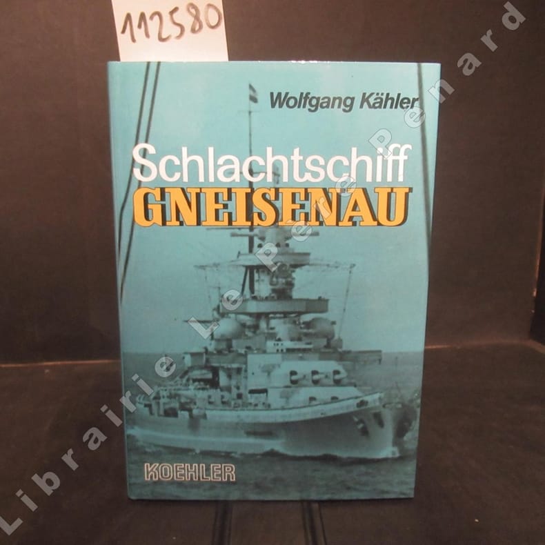
KAHLER, Wolfang
Schlachtschiff gneisenau
1988 Editions Koehler - 1988 - In-8, cartonnage toilé blanc avec titre noir suer le premier plat et au dos, sous jaquette illustrée - 172 p. - Quelques reproductions photographiques en N&B in-texte
Bookseller reference : 112580
|
|
|
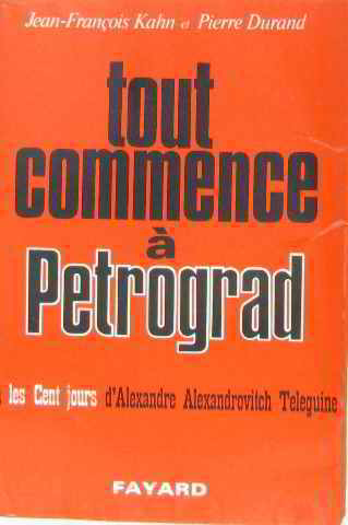
Kahn Durand
Tout commence à pétrograd
Fayard 1967 in8. 1967. Broché. frontispice carte
Bookseller reference : 174053
|
|
|
Kahn, Anna-Patricia
Die Sache zwischen uns : Israel, die Juden und die Deutschen.
[München] : Droemer, 2007. 191 S. 8°. Ill. orig. engl. Broschur.
Bookseller reference : 41117
|
|
|
KAHN, Jr. Chief Warrant Officer E.J.
Fighting Divisions. Histories of each US Army Combat Division in World War II. [Second Edition.] NEAR FINE COPY
8vo., Second Edition, with coloured plates of insignia and monochrome insignia in the text; green cloth, upper board and backstrip lettered in black, a near fine copy. Much-needed reissue of the original edition of 1946.

|
|
|
Kaiser, Ernst:
QXP im U-Boot auf Feindfahrt.
236 S. : Ill. ; 22 cm Ppbd. mit Umschlag. Zustand sehr gut. - The indicated shipping costs refer to books weighing up to one kilogram. - Bücher, die schwerer als ein Kilogramm oder größer als 35 x 25 cm sind, werden als Paket verschickt und kosten innerhalb Deutschlands bis zu zwei Kilogramm 6 Euro, darüber hinaus 7 Euro Porto. -
|
|
|
Kaiser, Franz Nikolaus
Das Ehrenbuch der Deutschen Schweren Artillerie. Herausgegeben vom Waffenring der ehemaligen Deutschen Schweren Artillerie, bearbeitet von Franz Nikolaus Kaiser, 1. Auflage,
Berlin: Verlag Tradition, Wilhelm Kolk, 1931. Mit einem farbign Frontispiz zahlreichen Skizzen, Tabellen, Fotografien sowie anderen teils ganzseitigen und farbigen Abildungen, 9 Bl., 603 Seiten, 33x26, schwarzes O Ln mit goldenem Rückentitel
Bookseller reference : 57339

|
|
|
Kaiser, Gerhard
Katyn. Das Staatsverbrechen - das Staatsgeheimnis. 1. Auflage
Berlin, Aufbau Taschenbuch Verlag, 2002.
Bookseller reference : 59183

|
|
|
Kaiser, Gerhard und Christian Thiel
Sperrgebiet. Die geheimen Kommandozentralen in Wünsdorf seit 1871. Mit Fotografien von Christian Thiel und Detlev Steinberg. 1. Aufl.
Berlin : Links, 1993. 199 S. Mit zahlr. Abb. Fadengehefteter Originalpappband.
Bookseller reference : 1037278

|
|
|
Kaiser, Jos. M
Joseph Freiherr von Rath, k.k. Feldmarschall Lieutnant. Orig. Lithographie
Linz 1851. Darstellung ca. 22x28 cm, Blattgröße ca. 33,5x43 cm, in der Platte signiert und datiert, auf chamoix Karton, in re. unt. Ecke Tl. eines Prägestempels, staubrandig, sehr guter Zustand. Brustbild v. vorne, en face nach r., Schnurrbart, in Uniform, Koppel, mit Ordenskreuz und drei Orden, l. Hand auf Säbelknauf gestützt.
Bookseller reference : GRAP0253
|
|
|
KAISER, Peter:
Auf den Spuren der Mechanisierten Division 4 - Eine Heereseinheit im Wandel der Zeit.
Solothurn, Vogt-Schild AG, 1994, in-8vo, 275 S., Original-Pappban, sehr guter Zustand.
Bookseller reference : 104087aaf
|
|
|
KAISER, Peter:
Auf den Spuren der Mechanisierten Division 4 - Eine Heereseinheit im Wandel der Zeit.
Solothurn, Vogt-Schild AG, 1994, in-8vo, 277 S., Original-Pappban, sehr guter Zustand.
Bookseller reference : 134123aaf
|
|
|
KAISERLICH un KONIGLICHES MILITAR GEOGRAPHISCHES INSTITUT.
MAP K.12. Ragusa Dubrovnik.
Wien: Kaiserlich und K�nigliches Milit�r-Geographisches Institut 1876. Soft cover. Good. Folio - over 12 - 15" tall. Original color map on cloth. Some tears on foldings. Good. Folded. Oblong folio. 45 x 51 cm. In German. Shows Stolac Metkovic Ljubinje Bilek Niksic Trebinje Ragusa Meleda Island Cattaro et alli. Ragusa is a Croatian city on the Adriatic Sea. It is one of the most prominent tourist destinations in the Mediterranean Sea a seaport and the centre of Dubrovnik-Neretva County. A sheet of the collection of 'The general map of Central Europe'. appeared in the years between 1873-1876 with the work of Joseph Ritter von Scheda 1815-1888 who was a general geographer and cartographer. <br/> <br/> Kaiserlich und K�nigliches Milit�r-Geographisches Institut paperback
Bookseller reference : 045469
|
|
|
KAISERLICH KONIGLISCHES MILITAR GEOGRAPHISCHES INSTITUT.
MAP of ANATOLIA O.14. Brussa. Southern Brussa - G�nen - Manias G�l -Lake- Anatolien Abulonia G�l -Lake-.
Wien: Kaiserlich-K�nigliches Milit�r-Geographisches Institut 1876. Soft cover. Very Good. Folio - over 12 - 15" tall. Original color map on cloth. Folded. A good copy. Oblong folio. 45 x 51 cm. In German. MAP O.14. Brussa. Southern Brussa - G�nen - Manias G�l -Lake- Anatolien Abulonia G�l -Lake-. Shows Abhuitis See Artynia See Kirmisli Kasaba etc. A sheet of the collection of 'The general map of Central Europe'. appeared in the years between 1873-1876 with the work of Joseph Ritter von Scheda 1815-1888 who was a general geographer and cartographer. <br/> <br/> Kaiserlich-K�nigliches Milit�r-Geographisches Institut paperback
Bookseller reference : 045519
|
|
|
KAISERLICH KONIGLISCHES MILITAR GEOGRAPHISCHES INSTITUT.
MAP of BALKANS J.10. Glina.
Wien: Kaiserlich-K�nigliches Milit�r-Geographisches Institut 1876. Soft cover. Very Good. Folio - over 12 - 15" tall. Original color map on cloth. Oblong atlas folio. 46 x 52 cm. Toponyms in German. MAP of BALKANS J.10. Glina and around. North Bosnia and Herzegovina sheet. A sheet of the collection of 'The general map of Central Europe'. appeared in the years between 1873-1876 with the work of Joseph Ritter von Scheda 1815-1888 who was a general geographer and cartographer. <br/> <br/> Kaiserlich-K�nigliches Milit�r-Geographisches Institut paperback
Bookseller reference : 046198
|
|
|
KAISERLICH KONIGLISCHES MILITAR GEOGRAPHISCHES INSTITUT.
MAP of BULGARIA O.11. Rus�uk. Ruse. Donau River Plevna Nikoli.
Wien: Kaiserlich-K�nigliches Milit�r-Geographisches Institut 1876. Soft cover. Very Good. Folio - over 12 - 15" tall. Original color map on cloth. Folded. A good copy. Oblong folio. 45 x 51 cm. In German. MAP of BULGARIA. Rus�uk. Ruse. Donau River Plevna Nikoli. A sheet of the collection of 'The general map of Central Europe'. appeared in the years between 1873-1876 with the work of Joseph Ritter von Scheda 1815-1888 who was a general geographer and cartographer. <br/> <br/> Kaiserlich-K�nigliches Milit�r-Geographisches Institut paperback
Bookseller reference : 045521
|
|
|
KAISERLICH KONIGLISCHES MILITAR GEOGRAPHISCHES INSTITUT.
MAP of BULGARIA Q.10. K�stendze Constanta. Bulgaria. Schwarzes Meer Black Sea.
Wien: Kaiserlich-K�nigliches Milit�r-Geographisches Institut 1876. Soft cover. Very Good. Folio - over 12 - 15" tall. Original color map on cloth. Folded. Oblong folio. 45 x 51 cm. In German. MAP Q.10. K�stendze Constanta. Bulgaria. Schwarzes Meer Black Sea. A sheet of the collection of 'The general map of Central Europe'. appeared in the years between 1873-1876 with the work of Joseph Ritter von Scheda 1815-1888 who was a general geographer and cartographer. <br/> <br/> Kaiserlich-K�nigliches Milit�r-Geographisches Institut paperback
Bookseller reference : 045522
|
|
|
KAISERLICH KONIGLISCHES MILITAR GEOGRAPHISCHES INSTITUT.
MAP of GREECE N.14. Salonik Salonica - Thessaloniki - Salonique. Platamora Aegaisches Meer Larissa.
Wien: Kaiserlich-K�nigliches Milit�r-Geographisches Institut 1876. Soft cover. Very Good. Folio - over 12 - 15" tall. Original color map on cloth. Folded. A good copy. Oblong folio. 45 x 51 cm. In German. MAP of GREECE N.14. Salonik Salonica - Thessaloniki - Salonique. Platamora Aegaisches Meer Larissa. A sheet of the collection of 'The general map of Central Europe'. appeared in the years between 1873-1876 with the work of Joseph Ritter von Scheda 1815-1888 who was a general geographer and cartographer. <br/> <br/> Kaiserlich-K�nigliches Milit�r-Geographisches Institut paperback
Bookseller reference : 045520
|
|
|
KAISERLICH KONIGLISCHES MILITAR GEOGRAPHISCHES INSTITUT.
MAP of GREECE N.15. Phersala Farsala. Gulf von Volo Canal v. Triche I. Egripo Euboea Evvia Canal Orei Kirtzini Armiro Chalkis etc.
Wien: Kaiserlich-K�nigliches Milit�r-Geographisches Institut 1876. Soft cover. Very Good. Folio - over 12 - 15" tall. Original color map on cloth. Folded. A good copy. Oblong folio. 45 x 51 cm. In German. MAP of GREECE N.15. Phersala Farsala. Gulf von Volo Canal v. Triche I. Egripo Euboea Evvia Canal Orei Kirtzini Armiro Chalkis etc. A sheet of the collection of 'The general map of Central Europe'. appeared in the years between 1873-1876 with the work of Joseph Ritter von Scheda 1815-1888 who was a general geographer and cartographer. <br/> <br/> Kaiserlich-K�nigliches Milit�r-Geographisches Institut paperback
Bookseller reference : 045527
|
|
|
KAISERLICH KONIGLISCHES MILITAR GEOGRAPHISCHES INSTITUT.
MAP of OTTOMAN BALKANS L.14. Berat.
Wien: Kaiserlich-K�nigliches Milit�r-Geographisches Institut 1876. Soft cover. Very Good. Folio - over 12 - 15" tall. Original color map on cloth. Oblong atlas folio. 46 x 52 cm. Toponyms in German. MAP of OTTOMAN BALKANS L.14. Berat. Shows South Albanian shores Corfu Berat et alli. Lithography. Argyrokastro. A sheet of the collection of 'The general map of Central Europe'. appeared in the years between 1873-1876 with the work of Joseph Ritter von Scheda 1815-1888 who was a general geographer and cartographer. <br/> <br/> Kaiserlich-K�nigliches Milit�r-Geographisches Institut paperback
Bookseller reference : 046200
|
|
|
KAISERLICH und KONIGLISCHES MILITAR GEOGRAPHISCHES INSTITUT.
MAP of OTTOMAN BALKANS L.14. Berat Argyrokastro.
Wien: Kaiserlich und K�nigliches Milit�r-Geographisches Institut 1876. Soft cover. Very Good. Folio - over 12 - 15" tall. Original color map on cloth. Folded. Oblong folio. 45 x 51 cm. In German. MAP of OTTOMAN BALKANS L.14. Berat Argyrokastro. Shows South Albanian shores Corfu Berat et alli. A sheet of the collection of 'The general map of Central Europe'. appeared in the years between 1873-1876 with the work of Joseph Ritter von Scheda 1815-1888 who was a general geographer and cartographer. <br/> <br/> Kaiserlich und K�nigliches Milit�r-Geographisches Institut paperback
Bookseller reference : 046199
|
|
|
KAISERLICH KONIGLISCHES MILITAR GEOGRAPHISCHES INSTITUT.
MAP of OTTOMAN BALKANS 0.13. Xanthi. Northern Greece - Western Thrace. Iske�e.
Wien: Kaiserlich-K�nigliches Milit�r-Geographisches Institut 1876. Soft cover. Very Good. Folio - over 12 - 15" tall. Original color map on cloth. Folded. A good copy. Oblong folio. 45 x 51 cm. In German. MAP of OTTOMAN BALKANS 0.13. Xanthi. Northern Greece - Western Thrace. Iske�e. A sheet of the collection of 'The general map of Central Europe'. appeared in the years between 1873-1876 with the work of Joseph Ritter von Scheda 1815-1888 who was a general geographer and cartographer. <br/> <br/> Kaiserlich-K�nigliches Milit�r-Geographisches Institut paperback
Bookseller reference : 045525
|
|
|
KAISERLICH KONIGLISCHES MILITAR GEOGRAPHISCHES INSTITUT.
MAP of OTTOMAN BALKANS L.12. Durazzo. Vilajet Scutari - Nord Albanien - Prizren. Scutari Province - North Albania.
Wien: Kaiserlich-K�nigliches Milit�r-Geographisches Institut 1876. Soft cover. Very Good. Folio - over 12 - 15" tall. Original color map on cloth. Folded. A good copy. Oblong folio. 45 x 51 cm. In German. MAP of OTTOMAN BALKANS L.12. Durazzo. Vilajet Scutari - Nord Albanien - Prizren. Scutari Province - North Albania. A sheet of the collection of 'The general map of Central Europe'. appeared in the years between 1873-1876 with the work of Joseph Ritter von Scheda 1815-1888 who was a general geographer and cartographer. <br/> <br/> Kaiserlich-K�nigliches Milit�r-Geographisches Institut paperback
Bookseller reference : 045524
|
|
|
KAISERLICH KONIGLISCHES MILITAR GEOGRAPHISCHES INSTITUT.
MAP of OTTOMAN BALKANS L.13. Durazzo. Vilajet Scutari - Mittel Albanien. Scutari Province - Middle Albania.
Wien: Kaiserlich-K�nigliches Milit�r-Geographisches Institut 1876. Soft cover. Very Good. Folio - over 12 - 15" tall. Original color map on cloth. Folded. A good copy. Oblong folio. 45 x 51 cm. In German. MAP of OTTOMAN BALKANS L.13. Durazzo. Vilajet Scutari - Mittel Albanien. Scutari Province - Middle Albania. Turkish toponyms in German. A sheet of the collection of 'The general map of Central Europe'. appeared in the years between 1873-1876 with the work of Joseph Ritter von Scheda 1815-1888 who was a general geographer and cartographer. <br/> <br/> Kaiserlich-K�nigliches Milit�r-Geographisches Institut paperback
Bookseller reference : 045515
|
|
|
KAISERLICH KONIGLISCHES MILITAR GEOGRAPHISCHES INSTITUT.
MAP of OTTOMAN BALKANS P.13. Dimotika. Northern Greece - Western Thrace - Evros.
Wien: Kaiserlich-K�nigliches Milit�r-Geographisches Institut 1876. Soft cover. Very Good. Folio - over 12 - 15" tall. Original color map on cloth. Folded. A good copy. Oblong folio. 45 x 51 cm. In German. MAP of OTTOMAN BALKANS P.13. Dimotika. Northern Greece - Western Thrace - Evros. A sheet of the collection of 'The general map of Central Europe'. appeared in the years between 1873-1876 with the work of Joseph Ritter von Scheda 1815-1888 who was a general geographer and cartographer. <br/> <br/> Kaiserlich-K�nigliches Milit�r-Geographisches Institut paperback
Bookseller reference : 045518
|
|
|
KAISERLICH KONIGLISCHES MILITAR GEOGRAPHISCHES INSTITUT.
MAP of OTTOMAN BALKANS P.9. Galatz - Donau River.
Wien: Kaiserlich-K�nigliches Milit�r-Geographisches Institut 1876. Soft cover. Very Good. Folio - over 12 - 15" tall. Original color map on cloth. Folded. A good copy. Oblong folio. 45 x 51 cm. In German. MAP of OTTOMAN BALKANS P.9. Galatz - Donau River. A sheet of the collection of 'The general map of Central Europe'. appeared in the years between 1873-1876 with the work of Joseph Ritter von Scheda 1815-1888 who was a general geographer and cartographer. <br/> <br/> Kaiserlich-K�nigliches Milit�r-Geographisches Institut paperback
Bookseller reference : 045517
|
|
|
KAISERLICH KONIGLISCHES MILITAR GEOGRAPHISCHES INSTITUT.
MAP of OTTOMAN BALKANS N.13. Seres. Serres. Greece - Macedonia.
Wien: Kaiserlich-K�nigliches Milit�r-Geographisches Institut 1876. Soft cover. Very Good. Folio - over 12 - 15" tall. Original color map on cloth. Folded. A good copy. Oblong folio. 45 x 51 cm. In German. MAP of OTTOMAN BALKANS N.13. Seres. Serres. Greece - Macedonia. A sheet of the collection of 'The general map of Central Europe'. appeared in the years between 1873-1876 with the work of Joseph Ritter von Scheda 1815-1888 who was a general geographer and cartographer. <br/> <br/> Kaiserlich-K�nigliches Milit�r-Geographisches Institut paperback
Bookseller reference : 045526
|
|
|
KAISERLICH KONIGLISCHES MILITAR GEOGRAPHISCHES INSTITUT.
MAP of OTTOMAN BALKANS M.13. Monastir K�pr�l�. Macedonia.
Wien: Kaiserlich-K�nigliches Milit�r-Geographisches Institut 1876. Soft cover. Very Good. Folio - over 12 - 15" tall. Original color map on cloth. Folded. Oblong folio. 45 x 51 cm. In German. MAP of OTTOMAN BALKANS M.13. Monastir K�pr�l�. Macedonia. A sheet of the collection of 'The general map of Central Europe'. appeared in the years between 1873-1876 with the work of Joseph Ritter von Scheda 1815-1888 who was a general geographer and cartographer. <br/> <br/> Kaiserlich-K�nigliches Milit�r-Geographisches Institut paperback
Bookseller reference : 045523
|
|
|
KAISERLICH KONIGLISCHES MILITAR GEOGRAPHISCHES INSTITUT.
MAP of OTTOMAN BALKANS 0.13. Xanthi. Northern Greece - Western Thrace Iske�e.
Wien: Kaiserlich-K�nigliches Milit�r-Geographisches Institut 1876. Soft cover. Very Good. Folio - over 12 - 15" tall. Original color map on cloth. Folded. A good copy. Oblong folio. 45 x 51 cm. In German. MAP of OTTOMAN BALKANS 0.13. Xanthi. Northern Greece - Western Thrace Iske�e. A sheet of the collection of 'The general map of Central Europe'. appeared in the years between 1873-1876 with the work of Joseph Ritter von Scheda 1815-1888 who was a general geographer and cartographer. <br/> <br/> Kaiserlich-K�nigliches Milit�r-Geographisches Institut paperback
Bookseller reference : 045516
|
|
|
KAISERLICH und KONIGLISCHES MILITAR GEOGRAPHISCHES INSTITUT.
MAP of ROMANIA N.9. Hermannstadt Sibiu.
Wien: Kaiserlich und K�nigliches Milit�r-Geographisches Institut 1876. Soft cover. Very Good. Folio - over 12 - 15" tall. Original color map on cloth. A little foxing on cloth. Very good. Folded. Oblong folio. 45 x 51 cm. In German. Shows N. Enyed Zalathna Mediasch Hermannstadt Hatszeg Petroseni �zt River etc. Scale: 1/300.000. MAP of ROMANIA N.9. Hermannstadt. Sibiu Sibiiu - Hermannstadt - Nagyszeben is a city in Transylvania Romania. The city straddles the Cibin River a tributary of the river Olt. The first official record referring to the Sibiu area comes from 1191 when Pope Celestine III confirmed the existence of the free prepositure of the German settlers in Transylvania the prepositure having its headquarters in Sibiu named Cibinium at that time. In the 14th century it was already an important trade centre. In 1376 the craftsmen were divided in 19 guilds. Sibiu became the most important ethnic German city among the seven cities that gave Transylvania its German name Siebenb�rgen literally seven citadels. It was home to the Universitas Saxorum Community of the Saxons a network of pedagogues ministers intellectuals city officials and councilmen of the German community forging an ordered legal corpus and political system in Transylvania since the 1400s. During the 18th and 19th centuries the city became the second- and later the first-most important centre of Transylvanian Romanian ethnics. The first Romanian-owned bank had its headquarters here The Albina Bank as did the ASTRA Transylvanian Association for Romanian Literature and Romanian's People Culture. After the Romanian Orthodox Church was granted status in the Habsburg Empire from the 1860s onwards Sibiu became the Metropolitan seat and the city is still regarded as the third-most important centre of the Romanian Orthodox Church. Between the Hungarian Revolution of 1848 and 1867 the year of the Ausgleich Sibiu was the meeting-place of the Transylvanian Diet which had taken its most representative form after the Empire agreed to extend voting rights in the region. Source: Wikipedia. A sheet of the collection of 'The general map of Central Europe'. appeared in the years between 1873-1876 with the work of Joseph Ritter von Scheda 1815-1888 who was a general geographer and cartographer. <br/> <br/> Kaiserlich und K�nigliches Milit�r-Geographisches Institut paperback
Bookseller reference : 045463
|
|
|
KAISERLICH un KONIGLICHES MILITAR GEOGRAPHISCHES INSTITUT.
MAP of ROMANIA P.8. Jassy Iashi - Moldau.
Wien: Kaiserlich und K�nigliches Milit�r-Geographisches Institut 1876. Soft cover. Very Good. Folio - over 12 - 15" tall. Original color map on cloth. A little foxing on cloth. Very good. Folded. Oblong folio. 45 x 51 cm. In German. Shows Tirgu Frumos Jassi Tzibana Kodaesti Brindza Negresti Becesti Pundzesti Birlaf Gaiciana Urdesti Falci etc. MAP of ROMANIA P.8. Jassy - Moldau. Scale: 1/300000. Jassy or Iassy Iasi is the second-largest city in Romania after the national capital Bucharest and the seat of Iasi County. Located in the historical region of Moldavia Iasi has traditionally been one of the leading centers of Romanian social cultural academic and artistic life. The city was the capital of the Principality of Moldavia from 1564 to 1859 then of the United Principalities from 1859 to 1862 and the capital of Romania from 1916 to 1918. Source: Wikipedia. A sheet of the collection of 'The general map of Central Europe'. appeared in the years between 1873-1876 with the work of Joseph Ritter von Scheda 1815-1888 who was a general geographer and cartographer. <br/> <br/> Kaiserlich und K�nigliches Milit�r-Geographisches Institut paperback
Bookseller reference : 045460
|
|
|
KAISERLICH KONIGLISCHES MILITAR GEOGRAPHISCHES INSTITUT.
MAP of ROMANIA M.10. Orsova. Danube River.
Wien: Kaiserlich-K�nigliches Milit�r-Geographisches Institut 1876. Soft cover. Very Good. Folio - over 12 - 15" tall. Original color map on cloth. Folded. A good copy. Oblong folio. 45 x 51 cm. In German. MAP of ROMANIA M.10. Orsova. Danube River. Orsova is a port city on the Danube river in southwestern Romania's Mehedini County. It is one of four localities in the county located in the Banat historical region. It is situated just above the Iron Gates on the spot where the Cerna River meets the Danube. A sheet of the collection of 'The general map of Central Europe'. appeared in the years between 1873-1876 with the work of Joseph Ritter von Scheda 1815-1888 who was a general geographer and cartographer. <br/> <br/> Kaiserlich-K�nigliches Milit�r-Geographisches Institut paperback
Bookseller reference : 045528
|
|
|
KAISERLICH un KONIGLICHES MILITAR GEOGRAPHISCHES INSTITUT.
MAP of WEST GREECE L.15. Paramythia Corfu. Jonisches Meer.
Wien: Kaiserlich und K�nigliches Milit�r-Geographisches Institut 1878. Soft cover. Very Good. Folio - over 12 - 15" tall. Original color map on cloth. A little foxing on cloth. Very good. Folded. Oblong folio. 45 x 51 cm. In German. MAP of WEST GREECE L. 15. Paramythia Corfu. Jonisches Meer. Scale: 1/300000. A sheet of the collection of 'The general map of Central Europe'. appeared in the years between 1873-1876 with the work of Joseph Ritter von Scheda 1815-1888 who was a general geographer and cartographer. <br/> <br/> Kaiserlich und K�nigliches Milit�r-Geographisches Institut paperback
Bookseller reference : 045459
|
|
|
KAISERLICH un KONIGLICHES MILITAR GEOGRAPHISCHES INSTITUT.
MAP of WEST GREECE L.15. Philiataes Corfu. Jonisches Meer.
Wien: Kaiserlich und K�nigliches Milit�r-Geographisches Institut 1878. Soft cover. Very Good. Folio - over 12 - 15" tall. Original color map on cloth. A little foxing on cloth. Very good. Folded. Oblong folio. 45 x 51 cm. In German. MAP of WEST GREECE L.15. Philiataes Corfu. Jonisches Meer. Scale: 1/300.000. A sheet of the collection of 'The general map of Central Europe'. appeared in the years between 1873-1876 with the work of Joseph Ritter von Scheda 1815-1888 who was a general geographer and cartographer. <br/> <br/> Kaiserlich und K�nigliches Milit�r-Geographisches Institut paperback
Bookseller reference : 045470
|
|
|
KAISERLICH KONIGLISCHES MILITAR GEOGRAPHISCHES INSTITUT.
MAP Q.11. Cap G�lgrad. Kaliakra Capo Calacria Celigra Burun and Schwarzes Meer Black Sea.
Wien: Kaiserlich-K�nigliches Milit�r-Geographisches Institut 1876. Soft cover. Very Good. Folio - over 12 - 15" tall. Original color map on cloth. Folded. Oblong folio. 45 x 51 cm. In German. MAP Q.11. Cap G�lgrad. Kaliakra Capo Calacria Celigra Burun and Schwarzes Meer Black Sea. Bulgarian Black Sea shores. A sheet of the collection of 'The general map of Central Europe'. appeared in the years between 1873-1876 with the work of Joseph Ritter von Scheda 1815-1888 who was a general geographer and cartographer. <br/> <br/> Kaiserlich-K�nigliches Milit�r-Geographisches Institut paperback
Bookseller reference : 045514
|
|
|
KAISERLICH und KONIGLISCHES MILITAR GEOGRAPHISCHES INSTITUT.
MAP Q.8. Odessa.
Wien: Kaiserlich und K�nigliches Milit�r-Geographisches Institut 1876. Soft cover. Very Good. Folio - over 12 - 15" tall. Original color map on cloth. A little foxing on cloth. Very good. Folded. Oblong folio. 45 x 59 cm. In German. Shows Kujaljnickij Limani Dnjesstrowskij Liman Odessa shores and hinterland. Rare. A sheet of the collection of 'The general map of Central Europe'. appeared in the years between 1873-1876 with the work of Joseph Ritter von Scheda 1815-1888 who was a general geographer and cartographer. <br/> <br/> Kaiserlich und K�nigliches Milit�r-Geographisches Institut paperback
Bookseller reference : 046201
|
|
 Receive by email
 Download as PDF document
 RSS feed


