|
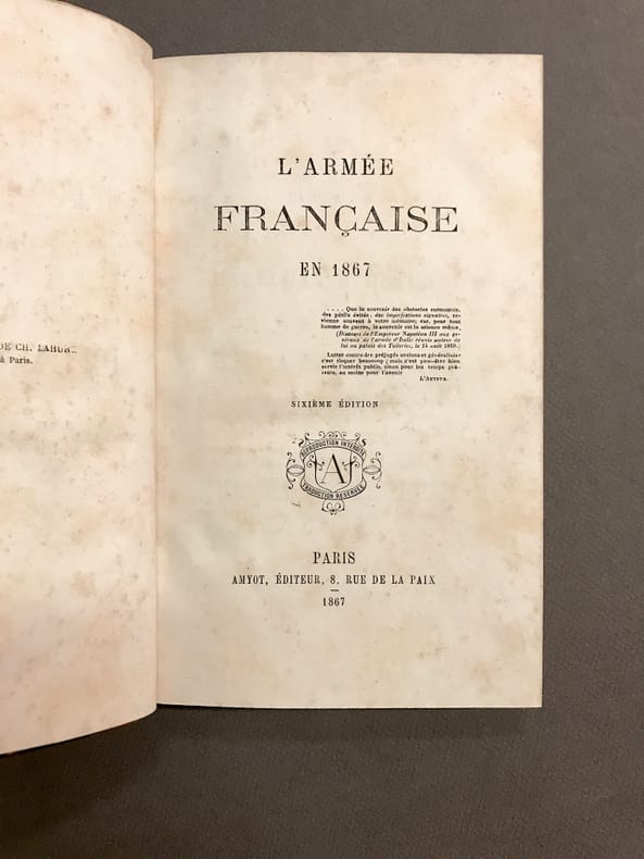
[TROCHU (Gal. Louis-Jules)]
L'armée française en 1867. Sixième édition.
Paris, Amyot, 1867. in-8, 3ff.-Xpp.-287pp. Relié à l'époque demi-basane fauve, dos lisse, pièce de titre.
书商的参考编号 : 24836
|
|
|
[VILLEBOIS-MAREUIL (Georges de)]
L' Armée russe et ses chefs en 1888.. Par l'auteur du Maréchal Moltke.
Paris, Librairie Moderne, 1889; in-12, 296 pp., demi-basane havane, dos lisse orné de filets dorés (reliure de l'époque). Coiffe absente, dos frotté et passé. Epidermures. Coupes et coins usés. Cachets (annulés).
书商的参考编号 : 210457
|
|
|
Anonyme Collectif des armées
Journal de l'armée. 2e année - Tome 2
Paris, au bureau du journal rue de la Victoire, 9 bis - 1834 - In-8°, reliure demi basane sur papier caillouté et tranche verte sobrement titrée en doré, 388 pages en contunue sur les 12 N°, pas de planches pour cet exemplaire sur différentes qualités de papier, comprenant un texte complet sur deux colonnes ( non épidermé ).
书商的参考编号 : 15802

|
|
|
Anonyme.
Album Militaire
In-4° format italien, sous reliure de demi-cuir. Sans trace d'éditeur. Nombreuses gravures et reproductions en N&B sur l'armée française. Environ 1900.
书商的参考编号 : DIV493C217
|
|
|
ARDOUIN-DUMAZET, Victor-Eugène [Section photographique des armées]
La guerre, documents de la section photographique de l'armée
Armand Colin 1916 Collection complète des 20 fascicules en un volume in-4 à l’italienne, demi-basane verte à coins, dos à nerfs, 280 pp., 480 planches en noir. Sans les titres et couvertures.
书商的参考编号 : 73909
|
|
|
ARMEE FRANCAISE D'OUTRE-MER
L'épopée de l'armée française d'Outre-Mer. Document pour servir à l'histoire de la part qu'ont prise les troupes françaises, spécialement celles d'Outre-Mer - à la libération de nos térritoires et à la victoire.
Couverture souple. Broché. 212 pages.
书商的参考编号 : 106170

|
|
|
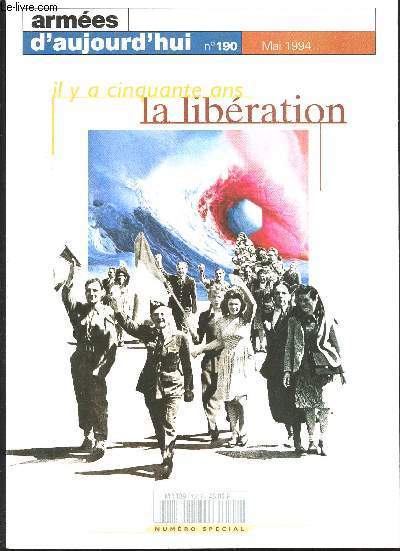
ARMEES D' AUJOURD'HUI.
Il y a cinquante ans, la Libération. Numéro spécial de Mai 1994.
. Non daté. In-4. Broché. Bon état, Couv. convenable, Dos satisfaisant, Intérieur frais. Paris, Revue des Forces Armées Françaises, Mai 1994, revue mensuelle in 4, broché, très nb. photos, 275 pp.. . . . Classification Dewey : 940.53-Seconde Guerre mondiale 1939-1945
书商的参考编号 : R300262396
|
|
|
armees navales et arcenaux de marine.
Ordonnance de Louis XIV pour les armees navales et arcenaux de marine.reimpression
A paris Chez Estienne Michallet.,reimpression de lӎdition de Paris 1689) table +408p In-8,broche BON EXEMPLAIRE.
书商的参考编号 : 17097
|
|
|
Armies of the American Wars : 1753 1815 Philip Katcher Katcher
Armies of the American Wars : 1753-1815 Philip
Very Good. well illus.Uniformsinsignia weapons.Fine/Fine dust jacket. unknown
书商的参考编号 : 10838
|
|
|
armée,anonyme
(armée)Règlement sur les réparations,l’entretien et la conservation des armes portatives dans les Corps.Suivi des diverses instructions et tarifs.
In 16 cartonné bleu titre imprimé au dos et sur le premier plat,faux-titre,titre,196 pages.40 figures en 3 planches dépliantes,à la suite:Tarifs dépliants pour les réparations des armes portatives,armes blanches F.G Levrault 1825.Bon exemplaire
书商的参考编号 : 710
|
|
|
ARMÉES FRANÇAISES D’OUTRE MER
L'Armée française en Tunisie [rédigé par le sous-lieutenant de réserve Paquel,... le capitaine Jobin,... le capitaine Voyron,... le lieutenant-colonel Faveris,...]
Imp. Nationale 1931 In-4 broché, VII-182 pp. 11 planches hors-texte, cartes repliées. Etiquette au dos. Lég. humidité en pied.
书商的参考编号 : 51420
|
|
|
ARMÉES FRANÇAISES D’OUTRE MER
Le génie aux colonies
Imp. Nationale 1931 In-4 broché, XVI- 343 pp. 59 planches hors-texte, cartes repliées hors-texte. Couverture ternie, humidité angulaire en pied, parfois soutenue. Etiquette au dos.
书商的参考编号 : 51422
|
|
|
ARMÉES FRANÇAISES D’OUTRE MER
Le service de l'Intendance aux colonies [rédigé par M. l'Intendant général de 2e classe Gaucher... et M. L'Intendant de 2ème classe Rivière]
Imp. Nationale 1931 In-4 broché, non coupé, IV-291 pp.. Etiquette au dos. Importante humidité en pied. En l’état.
书商的参考编号 : 51423
|
|
|
ARMÉES FRANÇAISES D’OUTRE MER
Le service de santé aux colonies
Imp. Nationale 1931 In-4 broché, non coupé, 451 pp. 8 planches hors-texte. Etiquette au dos. Couverture lég. ternie.
书商的参考编号 : 51424
|
|
|
ARMÉES FRANÇAISES D’OUTRE MER
Les troupes coloniales pendant la guerre 1914-1918 [rédigé par les lieutenant-colonel Charbonneau, lieutenant-colonel Dop, lieutenant-colonel Viraud, capitaine Bourgeois-Gavardin]
Imp. Nationale 1931 In-4 broché, 502 pp. Cartes hors-texte. Couverture ternie, lég. hum. en pied.
书商的参考编号 : 51426
|
|
|
Armées révolutionnaires
Armée des Pyrénées Orientales, Transports militaires
Lot de 8 pièces concernant un soldat originaire de Pont Saint Esprit et servant dans l'armée des Pyrénées Orientales; Certificats, laissez-passer, etc… Année 1794 En feuilles Très bon Pont St Esprit Papiers Rédarès 1794
书商的参考编号 : 10173

|
|
|
Association Promotion Extrême Orient - Préface du commandant Hélie Denoix de Saint Marc - Compositions en couleurs d'André MONTAGNÉ, peintre officiel des Armées.
Paroles d'Officiers - 1950 - 1990 - Des Saints-Cyriens témoignent
TOULOUSE, imp; Corep - 1991 - E.O. - Grand et fort In-4, 31x22 cm - Reliure pleine toile éditeur sous jaquette illustrée en couleurs (accroc) - Signet - Très nombreuses rproductions photographiques, et des compositions en couleurs d'André Montagné Peintre officiel des armées - 654 pages - Bon exemplaire - envoi rapide et soigné
书商的参考编号 : 27517
|
|
|
Atlas to Accompany the Official Records of the Union and Confederate Armies 1861 1865
Civil War Map-- Virginia: Plates VII and VIII-- Surveys for Military Defenses Map of Northeastern Virginia and Vicinity of Washington . Sheets 1 & 2
New York: Julius Bien & Co. Lith. 1892. Two color printed sheets sold as a set from this important civil war atlas. Exquisitely specific detail on the data used for compilation topographical info. positions of Union and Confederate works local buildings roads numerous buildings and general landmarks. "Accompanying the report of Maj. Gen. George B. McClellan U.S. Army Series 1 Vol. 5 Page 5." Both sheets VG w/minimal browning and slightly chipped margins w/ a few small marginal tears. Sheet 1 Plate VII has a stain mainly affecting verso upper left. Each sheet is 41x69cm. The above date is approximate. First Edition Thus. Julius Bien & Co. Lith. unknown
书商的参考编号 : 566
|
|
|
Atlas to Accompany the Official Records of the Union and Confederate Armies 1861 1865
Civil War Map of USA-- Plate165: Map of the United States of America Showing the BOundaries of the Union and Confederate Geographical Divisions and Departments June 30 1862
Julius Bien & Co. Lith. NY 1895. Near fine color printed map from this impressive atlas. Very detailed coastal topographical canal railroad info. Indicates forts color coded for seceding states as of the map date. At this time the Army of the Potomac McClellan and the Army o f Northern Virginia Lee were operating in area of Richmond Va. The US forces of the Rappahannock Shenandoah and Mountain Departments were consolidated inot the Army of Virginia POPE. Image 42x70 cm 16.5x27.5 inches. As these sheets were issued in separate fascicles the date is approximate. Julius Bien & Co. Lith., NY unknown
书商的参考编号 : 3321
|
|
|
Atlas to Accompany the Official Records of the Union and Confederate Armies 1861 1865
Civil War Map- Plate 170: Map of the United States of America Showing the Boundaries of the Union and Confederate Geographical Divisions and Departments Dec. 31 1864
New York: Julius Bien & Co. Lith. 1895. VG. This is one of several detailed chromolithographic maps of this temporal series indicating the general course of the civil war taken from this important and impressive atlas. The general general sections used are labeled and outlined in deep b lue. There is a notation re: Meade's Army of the Potomac and Lee's Army of Northern Virginia operations near Petersburg Virginia. A separate notation mentions Sherman's troops in the environs of Savannah GA. Image 42x70 cm 16.5x27.5 inches. As these sheets were issued in separate fascicles the date is approximate. Julius Bien & Co. Lith., unknown
书商的参考编号 : 3326
|
|
|
Atlas to Accompany the Official Records of the Union and Confederate Armies 1861 1865
Civil War Map- Plate 168: Map of the United States of America Showing the Boundaries of the Union and Confederate Geographical Divisions and Departments Dec. 31 1863
New York: Julius Bien & Co. Lith. 1895. Near fine. This is one of several detailed chromolithographic maps of this temporal series indicating the general course of the civil war taken from this important and impressive atlas. The general sections used are labeled and outlined in deep b lue. There is a notation re: Meade's Army of the Potomac and Lee's Army of Northern Virginia operations near the Rapidan River Virginia. Image 42x70 cm 16.5x27.5 inches. As these sheets were issued in separate fascicles the date is approximate. Julius Bien & Co. Lith., unknown
书商的参考编号 : 3324
|
|
|
Atlas to Accompany the Official Records of the Union and Confederate Armies 1861 1865
Civil War Map of USA-- Plate164: Map of the United States of America Showing the Boundaries of the Union and Confederate Geographical Divisions and Departments Dec. 31 1861
Julius Bien & Co. Lith. NY 1895. Near fine color printed map from this impressive atlas. Very detailed coastal topographical canal railroad info. Indicates forts color coded for seceding states as of the map date not much change from preceding map but state boundaraies are be tter defined. Image 42x70 cm 16.5x27.5 inches. As these sheets were issued in separate fascicles the date is approximate. Julius Bien & Co. Lith., NY unknown
书商的参考编号 : 3320
|
|
|
Atlas to Accompany the Official Records of the Union and Confederate Armies 1861 1865
Civil War Map- Plate 167: Map of the United States of America Showing the Boundaries of the Union and Confederate Geographical Divisions and Departments June 30 1863
New York: Julius Bien & Co. Lith. 1895. Near fine. This is one of several chromolithographic maps of this temporal series indicating the general course of the civil war taken from this important and impressive atlas. The general general sections used are labeled and outlined in deep blue. There is a notation re: Meade's Army of the Potomac and Lee's Army of Northern Virginia operations near Gettysburg. Image 42x70 cm 16.5x27.5 inches. As these sheets were issued in separate fascicles the date is approximate. Julius Bien & Co. Lith., unknown
书商的参考编号 : 3323
|
|
|
Atlas to Accompany the Official Records of the Union and Confederate Armies 1861 1865
Civil War Map of USA-- Plate 166: Map of the United States of America Showing the BOundaries of the Union and Confederate Geographical Divisions and Departments Dec. 31 1862
New York: Julius Bien & Co. Lith. 1895. Near fine color printed map from this impressive atlas. Very detailed coastal topographical canal railroad info. Indicates forts color coded for seceding states as of the map date. As of this date the Army of the Potomac Burnside and the Army of Northern Virginia Lee were operating near Fredericksburg Va. Image 42x70 cm 16.5x27.5 inches. As these sheets were issued in separate fascicles the date is approximate. Julius Bien & Co. Lith. unknown
书商的参考编号 : 3322
|
|
|
Atlas to Accompany the Official Records of the Union and Confederate Armies 1861 1865
Civil War Map- Plate 171: Map of the United States of America Showing the Boundaries of the Union and Confederate Geographical Divisions and Departments April 9 1865
New York: Julius Bien & Co. Lith. 1895. Near fine. This is one of several detailed chromolithographic maps of this temporal series indicating the general course of the civil war taken from this important and impressive atlas. The general sections used are labeled and outlined in deep blue. There is a notation re: Meade's Army of the Potomac and Lee's Army of Northern Virginia operations near Appomattox Court-House Virginia. A separate notation mentions the confrontation between Sherman and Johnston's Army of Tennessee and o thers troops in between Raleigh and Goldsborough NC. Image 42x70 cm 16.5x27.5 inches. As these sheets were issued in separate fascicles the date is approximate. Julius Bien & Co. Lith., unknown
书商的参考编号 : 3327
|
|
|
Atlas to Accompany the Official Records of the Union and Confederate Armies 1861 1865
Map of Parts of Illinois Indiana Ohio Kentucky: General Topographical Map Sheet XVI Plate CLI
Julius Bien & Co. Lith. NY 1894. VG chromolithographic topograhical map from this impressive and important atlas. This is one of a number of general topographical sheets from the theater of war. There is extensive railroad and topographical detail. Cities listed on this sheet incl ude Louisville Lexington Cincinnati Columbus Vincennes Indianapolis Bloomington. 42x70cm. Julius Bien & Co. Lith., NY, 1894 unknown
书商的参考编号 : 860
|
|
|
Atlas to Accompany the Official Records of the Union and Confederate Armies 1861 1865
Map of DelMarVa Kentucky Ohio Pennsylvania-- Plate CXL: General Topographical Map Sheet V. Parts of Ohio Pennsylvania Maaryland Kentucky and West Virginia
Julius Bien & Co. Lith. NY c. 1894. VG color printed map from this impressive atlas. Very detailed coastal topographical canal railroad info. The plates from this section are indicated as "General Topographical Map of the Theatre of War." 42x69cm. Julius Bien & Co. Lith., NY, c. 1894 unknown
书商的参考编号 : 598
|
|
|
Atlas to Accompany the Official Records of the Union and Confederate Armies 1861 1865
Map of DelMarVa Washington D.C.-- Plate CXXXVII: General topographical Map Sheet II. Parts of Delaware District of Columbia Maryland Virginia and West Virginia
Julius Bien & Co. Lith. NY c. 1894. VG color printed map from this impressive atlas. Very detailed coastal topographical canal railroad info. Chesapeake Bay is very detailed here. The plates from this section are indicated as "General Topographical Map of the Theatre of War." 42x69 cm. Julius Bien & Co. Lith., NY, c. 1894 unknown
书商的参考编号 : 595
|
|
|
Atlas to Accompany the Official Records of the Union and Confederate Armies 1861 1865
Map of Maryland: Maps of Harper's Ferry/ Sharpsburg and Antietam
Julius Bien & Co. Lith. NY c.1894. Large map VG- with minor browning andsmall insect hole lower margin edge. Larger of 2 maps is "Antietam"; other map is ""Map of the Battler-Fields of Harper's Ferry and Sharpsburg". Small left borer tear just crosses neatline. Outline and divisiona l color with confederate advance and retreat lines coded for Antietam. Plate XXIX of this major civil war atlas. 41.5x68.5cm. Julius Bien & Co. Lith., NY, c.1894 unknown
书商的参考编号 : 256
|
|
|
Atlas to Accompany the Official Records of the Union and Confederate Armies 1861 1865
Map of Parts of Arkansas Louisiana Mississippi: General Topographical Map Sheet XX Plate CLV
Julius Bien & Co. Lith. NY 1894. VG chromolithographic topograhical map from this impressive and important atlas. This is one of a number of general topographical sheets from the theater of war. There is extensive railroad and topographical detail and prominent detail of the Miss issippi Red and Washita Rivers. 42x70cm. Julius Bien & Co. Lith., NY, 1894 unknown
书商的参考编号 : 864
|
|
|
Atlas to Accompany the Official Records of the Union and Confederate Armies 1861 1865
Map of Parts of Kentucky Ohio Virginia and West Virginia: General Topographical Map Sheet VI Plate CXLI
Julius Bien & Co. Lith. NY 1894. VG extensively detailed chromolithographic topographical map of this region. This is one of a number of general topographical maps of the theatre of war from this important and impressive atlas. 42x70cm. Julius Bien & Co. Lith., NY, 1894 unknown
书商的参考编号 : 850
|
|
|
Atlas to Accompany the Official Records of the Union and Confederate Armies
Map of Parts of Kansas Missouri Arkansas Indian Territories: General Topographical Map Sheet XXV Plate CLX
Julius Bien & Co Lith NY c. 1895. VG general topographical map chromolighograph from this important and impressive atlas. Slight right marginal browning and chipping without significant image impairment. This map has large area designated "Indian Territories" later includes most of Oklahoma. Tribal locations and Forts noted. Large areas designated "Cherokee Country" and "Creek Country". 41.5x69.5cm. Julius Bien & Co Lith, NY, c. 1895 unknown
书商的参考编号 : 1061
|
|
|
Atlas to Accompany the Official Records of the Union and Confederate Armies 1861 1865
Map of Parts of Missouri Arkansas Illinois Kentucky Tennessee: General Topographical Map Sheet XVIII Plate CLIII
Julius Bien & Co. Lith. NY 1894. VG chromolithographic topograhical map from this impressive and important atlas. This is one of a number of general topographical sheets from the theater of war. There is extensive railroad and topographical detail and prominent detail of the Miss issippi River. 42x70cm. Julius Bien & Co. Lith., NY, 1894 unknown
书商的参考编号 : 862
|
|
|
Atlas to Accompany the Official Records of the Union and Confederate Armies 1861 1865
Map of Parts of Mississippi Alabama and Georgia: General Topographical Map Sheet XIII Plate CXLVIII
Julius Bien & Co. Lith. NY 1894. VG extensively detailed chromolithographic topographical map of this region. This is one of a number of general topographical maps of the theatre of war from this important and impressive atlas. Railroad and waterway detail. 42x70cm. Julius Bien & Co. Lith., NY, 1894 unknown
书商的参考编号 : 857
|
|
|
Atlas to Accompany the Official Records of the Union and Confederate Armies 1861 1865
Map of Parts of South Carolina and Georgia: General Topographical Map Sheet IX Plate CXLIV
Julius Bien & Co. Lith. NY 1894. VG extensively detailed chromolithographic topographical map of this region. This is one of a number of general topographical maps of the theatre of war from this important and impressive atlas. Elaborate railroad and coastal detail. 42x70cm. Julius Bien & Co. Lith., NY, 1894 unknown
书商的参考编号 : 853
|
|
|
Atlas to Accompany the Official Records of the Union and Confederate Armies
Map of Parts of Virginia Georgia Missouri: 6 MAPS 1 SHEET includes: Sketch Showing the Positions of the Army on the Battle-Field of Chancellorsville VA May 1 to 5
Julius Bien & Co Lith NY c. 1894. VG chromolighographic map from this important and impressive atlas. There are detailed dated and color-coded troop positions of both armies on the Chancellorsville map. The other images besides Chancellorsville are: 1. Map of the Battlefield of W ilson's Creek MO 2. Section of Map of Buckingham and Appomattox Counties VA 3. Map of Hanover Henrico and Part of Chesterfield Counties VA 4.Battle of Cedar Mountain VA 5. Defenses of Macon GA 1864. 41.5x69.5cm. Julius Bien & Co Lith, NY, c. 1894 unknown
书商的参考编号 : 1062
|
|
|
Atlas to Accompany the Official Records of the Union and Confederate Armies
Map of Parts of Mississippi Louisiana: General Topographical Map Sheet XXI Plate CLVI
Julius Bien & Co Lith NY c. 1895. VG general topographical map chromolighograph from this important and impressive atlas. This map is quite detailed in the region of the Mississippi delta with mouth of Mississippi River. Includes Vermillion Cote Blanche Bays Lake Pontchartrain. 41.5x69.5cm. Julius Bien & Co Lith, NY, c. 1895 unknown
书商的参考编号 : 1060
|
|
|
Atlas to Accompany the Official Records of the Union and Confederate Armies 1861 1865
Map of Parts of Missouri and Illinois: General Topographical Map Sheet XVII Plate CLII
Julius Bien & Co. Lith. NY 1894. VG chromolithographic topograhical map from this impressive and important atlas. This is one of a number of general topographical sheets from the theater of war. There is extensive railroad and topographical detail and prominent detail of the Miss issippi and Missouri Rivers. 42x70cm. Julius Bien & Co. Lith., NY, 1894 unknown
书商的参考编号 : 861
|
|
|
Atlas to Accompany the Official Records of the Union and Confederate Armies 1861 1865
Map of Parts of Georgia Kentucky North Carolina South Carolina Tennessee and Virginia: General Topographical Map Sheet VII Plate CXLII
Julius Bien & Co. Lith. NY 1894. VG extensively detailed chromolithographic topographical map of this region. This is one of a number of general topographical maps of the theatre of war from this important and impressive atlas. 42x70cm. Julius Bien & Co. Lith., NY, 1894 unknown
书商的参考编号 : 851
|
|
|
Atlas to Accompany the Official Records of the Union and Confederate Armies 1861 1865
Map of Parts of North Carolina South Carolina Georgia: General Topographical Map Sheet VIII Plate CXLIII
Julius Bien & Co. Lith. NY 1894. VG extensively detailed chromolithographic topographical map of this region. This is one of a number of general topographical maps of the theatre of war from this important and impressive atlas. 42x70cm. Julius Bien & Co. Lith., NY, 1894 unknown
书商的参考编号 : 852
|
|
|
Atlas to Accompany the Official Records of the Union and Confederate Armies 1861 1865
Map of Southeastern USA: Military Map of the Marches of the United States Forces Under Command of Maj. Gen. W.T. Sherman U.S.A. During the Years 1863 1864 1865
Julius Bien & Co. Lith. NY c. 1894. G w/minimal browning. Small piece of margin not near neatline missing at upper centerfold. Very detailed w/full printed color. Lists various surveys used for info w/topographical details and postions of fortifications and Union & Confederate for ces. Also incates routes for Pursuit of Hood and 4th-14th-15th-16th-17th-20th Army Corps Cavalries. 41x69cm. Julius Bien & Co. Lith., NY, c. 1894 unknown
书商的参考编号 : 583
|
|
|
Atlas to Accompany the Official Records of the Union and Confederate Armies 1861 1865
Map of Utah: Territory and Military Department of Utah
New York: Julius Bien & Co. Lith. 1894. G w/some browning and staining predominantly back side of map. Small piece of margin not near neatline missing at upper centerfold matting would cover. Very detailed w/full original printed color. Lists various surveys used for info w/topographical details extending into southern Washington Terry. western Colorado Nebraska and Callifornia. There is a second small map: March routes of the Army of the Tennessee from Savannah Ga. to Columbia S.C. 1865. Full image both maps is 41x69cm. Julius Bien & Co. Lith. unknown
书商的参考编号 : 581
|
|
|
Atlas to Accompany the Official Records of the Union and Confederate Armies 1861 1865
Map of Virginia: Preliminary Map of a Part of the South Side of James River Va
Julius Bien & Co. Lith. NY c.1894. Large heavy paper map VG- w/minor marginal soiling. Inset map "The Battle-Field of Chancellorsville Va.". Some color divisions and outlines. Plate XCIII from this major civil war atlas. 41.5x69cm. Julius Bien & Co. Lith., NY, c.1894 unknown
书商的参考编号 : 254
|
|
|
Atlas to Accompany the Official Records of the Union and Confederate Armies 1861 1865
Map of Virginia: 4 inset maps mostly around Petersburgh VA
Julius Bien & Co. Lith. NY c.1894. Large map heavy paper from major civil war atlas. Some outline and divisional color. 4 inset maps on one sheet w/ main maps dealing with Engineering Dept and color coded batteries in position near Petersburgh. G w/ 2 small insect holes lower margin and small lower centerfold not affecting image. Minor soiling. 41.5x69cm. Julius Bien & Co. Lith., NY, c.1894 unknown
书商的参考编号 : 253
|
|
|
Atlas to Accompany the Official Records of the Union and Confederate Armies 1861 185
Map of Virginia--Civil War: Campaign Maps Army of the Potomac
Julies Bien & Co. Lith. NY 1894. Vg few verso archival tape repairs to small edge tears w/ divisional and outline color. 5 maps indexed on single sheet: 1. White House to Harrison's Landing 2. Siege of Yorktown VA. 3. Williamsburg to White House 4. Sketch No.1 Mulbery Island VA. 5. Sketch No. 2 Principal Work on Mulberry Isla nd VA. All "Prepared by Command of Maj. Gen. George B. McClellan USA Commanding Army of the Potomac". 41x69cm. Julies Bien & Co. Lith., NY, 1894 unknown
书商的参考编号 : 207
|
|
|
Atlas to Accompany the Official Records of the Union and Confederate Armies 1861 1865
Map of Virginia Georgia-- 5 of 6 plates on this sheet deal with environs of Wilderness Campaign: 1. Map of the Battle-Field of The Wilderness Va. 2. Map of the Battle-Field of Spotsylvania CH Va. 4 other plates shown
Julius Bien & Co. Lith. NY c. 1894. VG chromolithographic map with the 6 plates as noted. The other 4 are: 3. Map of the Country in the Vicinity of Todd's Tavern Va. 4. Map of the Battle-Fields of North Anna 5. Map of the Battle-Fields of the Totopotomoy and Bethesday Church Va. 6. Positions of the Army of the Ohio in Front of Dalton Ga. The image for all 6 plates measures 41x69cm 16.25x27 inches. Julius Bien & Co. Lith., NY, c. 1894 unknown
书商的参考编号 : 1336
|
|
|
Atlas to Accompany the Official Records of the Union and Confederate Armies 1861 1865
Map of Virginia-- Plate XVI: Part of the Map of the Military Department of Southeastern Virginia and Fort Monroe
Julius Bien Lith. Co. NY c. 1891. G chromolithographic map from this important atlas. There is some marginal browning and chipping which could be covered with matting. A few small marginal tears none near neatline are repaired on verso with archival tape. This map is elaborate f or its waterway road and railroad detail with mouths of James York Rappahannock and Potomac Rivers shown. Includes areas of Charlottesville Fredericksburg Richmond and Petersburg. The map is 41x69cm. Julius Bien Lith. Co., NY, c. 1891 unknown
书商的参考编号 : 1071
|
|
|
Atlas to Accompany the Official Records of the Union and Confederate Armies 1861 1865
Map of Virginia-- 2 MAPS 1 SHEET: 1. Copy of a Map Sheet No. 1 Military Reconnaissance Department of Virginia 2. Campaign Maps Army of the Potomac Map No. 1 Yorktown to Williamsburg
Julius Bien & Co Lith c. 1891. VG pair of chromolithographic maps on a single sheet from this important and impressive atlas. The positions of Union and Confederate forces are color coded. On the reconnaissance map there are detailed notes re: road conditions best places to c ross rivers etc. It depicts most of the area betwen Yorktown and Newport News Point including the Hampton Roads vicinity between the Chesapeake Bay and James River. On the campain map image there is an extensive list of "Authorities". 41x69cm. Julius Bien & Co Lith, c. 1891 unknown
书商的参考编号 : 1066
|
|
|
Atlas to Accompany the Official Records of the Union and Confederate Armies 1861 1865
Map of Western USA-- Plate CXXXIV: "Essayons" Topographical Map of California Nevada Oregon and Part of Idaho.1867
Julius Bien & Co. Lith. NY c. 1894. VG color printed map from this impressive atlas. The image is a bit confusing at first as the map is presented in sections with Oregon and Nevada off to the left with the California details to the right. California railroads esp. in San Francisco area are shown. Very detailed coastal and topographical info. 42x69cm. Julius Bien & Co. Lith., NY, c. 1894 unknown
书商的参考编号 : 600
|
|
|
Atlas to Accompany Official Records of the Union and Confederate Armies. 1861 1865.
Maps of Virginia etc.: Set of 10 inset maps see description
Julius Bien & Co. NY 1894. Interesting g due to browning and some repair crossing neatline at left margin. Very large map with most of image clear and clean. Ten seperate areas depicted as insets including battlefields scouting information fortifications forts sieges an d skirmishes. Includes areas in Florida and Kentucky. Color coded for Union and Confederate detail. Information on specific generals and forces. 41x68cm. Julius Bien & Co., NY, 1894 unknown
书商的参考编号 : 205
|
|
 ?????????
 ?????PDF???
 RSS feed
