|
Sanson d'Abbeville S.
L'Asie en plusieurs cartes nouvelles et exactes &c. en divers trait�s de geographie et d'histoire. L� o� sont descrits succinctement & avec une belle methode & facile. Ses empires ses monarchies ses estats &c. .
Paris: Chez L'autheur Book. Good. Full-Leather. 4to - over 9�" - 12" tall. 104 pages. Text only lacking all maps. Sound leather binding a little war at the top of the spine. Chez L'autheur Hardcover
Bookseller reference : 6235
|
|
|
SANSON D'ABBEVILLE Nicholas 1600 1667.
L'Asie.
Paris: Chez l'Autheur 1694 Single sheet 18 x 23 4/8 inches; 16 x 22 4/8 inches to the neat line. Double-page engraved map of Asia with original hand-colour in outline a little browned central vertical crease. A fine and very decorative map by Nicholas Sanson. The Frenchman Nicholas Sanson d'Abbeville 1600-1667 was the founder of the French School of Geography a school that was unprecedented in its attention to precision and scientific detail and discarded much of the decorative embellishments of previous maps as irrelevant. From Sanson's time in the second half of the seventeenth century until the latter part of the eighteenth century French geographical conceptions were more influential than those put forward by any other nation. This map gives a nice impression of Spain during its golden age. Paris: Chez l'Autheur, 1694 unknown
Bookseller reference : 72map221
|
|
|
SANSON D'ABBEVILLE Nicholas 1600 1667 DE VAUGONDY Gilles Robert 1688 1766
L'Europe divisee suivant l'etendue de ses principaux Etats subdivises en leurs principales Provinces
Paris: 1738 2 sheets joined sheet size 21 6/8 x 30 inches; 18 x 27 7/8 inches to the neat line full margins showing the plate mark. A fine engraved detailed map of Europe the title within a nicely ornamented Louis-XV-style cartouche upper right scale within a small sober cartouche the left part of the map is a kind of manual which gives some information on the scientific information the map provides in political geography natural geography and astronomic geography; with original hand color in outline spot on the upper middle margin vertical fold marks a little toned at the edges. A fine and very interesting political natural and astronomical map of Europe. Gilles Robert de Vaugondy 1688-1766 also known as Le Sieur or Monsieur Robert and his son Didier Robert de Vaugondy c.1723-1786 were leading mapmakers in France during the 18th century. In 1757 they published The 'Atlas Universel' in which they integrated older sources with more modern maps. This dialogue between old and new is also suitable for this map as it is originally made by Nicholas Sanson 1600-1667 who was the founder of the French school of cartography. Paris: 1738 unknown
Bookseller reference : 72EJD3
|
|
|
SANSON D'ABBEVILLE Nicholas 1600 1667 Alexis Hubert Jaillot 1632 1712
L'Europe divisee suivant l'estendue de les principaux Estats subdivises en leurs principales Provinces
Paris: H. Jaillot 1684 2 sheets joined sheet size 25 x 36 4/8 inches ; 21 5/8 x 35 inches to the neat line full margins showing the plate mark. A fine engraved detailed map of Europe the title as a running headline and within an extremely elaborate allegorical rococo cartouche showing the arms of Le Grand Dauphin Louis de France 1661-1711 detailed scale within a decorative cartouche lower right with original hand color in outline light fold marks a little toned at the edges. A fine and attractive map from a later issue of Jaillot's 'Atlas Nouveau'. The Frenchman Alexis-Hubert Jaillot 1632-1712 was the most important atlas compiler and publisher of the last quarter of the seventeenth century. The great fire of 1672 which destroyed the Blaeu empire was his opportunity to take over this part of the market. He and Nicolas Sanson 1600-1667 the founder of the French School of Geography had a working relationship which ended by the end of the 1670s this led to Jaillot developing his own series of atlases. Due to his tremendous importance and efforts Jaillot was given the title of Geographe du Roy by Louis XIV The 'Atlas Nouveau' was the result of the intense collaboration between Jaillot and the Sanson family. Shirley T-Jai - 1a. Paris: H. Jaillot, 1684 unknown
Bookseller reference : 72EJD1
|
|
|
SANSON D'ABBEVILLE Nicholas 1600 1667.
Les Deux Pole Arctique ou Septentrionale et Antarctique ou Meidionale �
Paris: 1657. Single sheet full margins original hand-color in outline 17 x 22 � inches sheet; 26 � x 32 inches framed An attractive double hemisphere map by "the Father of Cartogrpahy" Nicholas Sanson D'Abbeville. This map is based on the polar projections so as to include the northern and southern thirds of the world. The North Pole is found connected to Greenland and Spitzbergen but there is little other detailed coastline in the polar area. Europe Russia and Canada are delineated. The South Pole is based on the great unknown Southland of Magellan. The most southern tip of South America is shown and a large land mass "Terra Incognita" which encompasses the whole of the hemisphere but nothing else showing the limited extent of knowledge of these extreme latitudes. Extraordinarily enough though the southern projection which shows little more than the outline of a vast landmass 'Australe et Incogneue' roughly corresponding to Antarctica as we know it today long before any of it was discovered. Maps by Sanson in original colour are rare here with a colored outline. Nicolas Sanson 1600-1667 French cartographer who established the first great cartographic dynasty in France. He was tutor to Louis XIV. Sanson published over 300 maps and was a founder of the French school of mapmakers at a time when the leadership in European cartography passed from the Low Countries to France. For more information on this map or a warm welcome to see other maps and books of our collection at 72nd Street NYC please contact Natalie Zadrozna. . Paris: 1657. unknown
Bookseller reference : 72NZ131
|
|
|
SANSON D'ABBEVILLE Nicholas 1600 1667.
L�Europe en Plusiers Cartes et en divers Traites de Geographie et d�Histoire;. ses Empires ses Peuples ses Colonies leurs Moeurs Langues Religions Richesses�
Paris: Chez l�Autheur 1683. 4 parts in one volume. 4to. 8 5/8 x 6 5/8 inches. Four letterpress title-pages including one general title-page four indexes. 62 engraved double-page or folding maps maps of Italy and Turkey laid down to adjoining text leaves some light soiling and spotting. Contemporary mottled calf worn joints weak. Provenance: with early ownership inscription of Joseph Bromehead 1748-1826 writer of hymns and curate of Eckington Derbyshire on the title-page; and the early 20th-century inscription of �The Rentzes Cairo 8.1.53� on the recto of the first blank. Sanson�s series of quarto atlases were originally published separately as �L�Europe� in 1648 by Sanson�s son also Nicholas who was tragically killed in the �Barricades� insurrection the same year �L�Asie� in 1652 �L�Afrique� in 1656 and �L�Amerique� 1657. The maps of America include: �Amerique Septentrionale� �Canada ou Nouvelle France� �La Floride� �Mexico� Guadalajara� �Guatimala� �Les Isles Antilees� �Amerique MEridionale� �Terre Ferme� de Grenade� �Guiane� �Le Perou� �Le Chili� �Le Bresil� �Le Paraguay� �Detroit de Magellan�. Sanson published his first folio atlas in 1654 with 100 maps engraved and printed by Pierre Mariette; each held the copyright to half of the maps which bear their separate imprints and were issued progressively from 1630. Born in Abbeville a town in the Picardy region of France in 1600 Sanson was the most noted French cartographer in modern history. Mapmaker to Louis XIV King of France Sanson endowed his maps with the most recent geographical information as well as the finest and sharpest engraving of the period. His �Cartes Generales de Toutes les Parties du Monde� was the most important single product of French commercial cartography of the seventeenth century. Sanson sparked a renaissance in geographical endeavor in his native country which had not been a major player on the international cartographic stage since the great Oronce Fin� in the sixteenth century. With this atlas Sanson laid the foundations of French domination in map production initiating the so-called "French school of cartography" a school that was unprecedented in its attention to precision and scientific detail and discarded much of the decorative embellishments of previous maps as irrelevant. From Sanson's time in the second half of the seventeenth century until the latter part of the eighteenth century French geographical conceptions were more influential than those put forward by any other nation. Phillips 494 Sabin 76712n; Shirley T.San 3a 4a 5a 6a. Catalogued by Kate Hunter. Paris: Chez l�Autheur, 1683. unknown
Bookseller reference : 9c15-5
|
|
|
SANSON D'ABBEVILLE Nicholas 1600 1667.
L�Europe en Plusiers Cartes et en divers Traites de Geographie et d�Histoire;. ses Empires ses Peuples ses Colonies leurs Moeurs Langues Religions Richesses�
Paris: Chez l�Autheur 1683. 4 parts in one volume. 4to. 8 4/8 x 7 5/8 inches. Four letterpress title-pages including one general title-page four indexes lacking double-page engraved title-page. 62 engraved double-page or folding maps 14 with later hand-colour in outline one or two with archival repairs to folds on versos some inoffensive waterstaining to last few maps. Late 18th-century half calf marbled paper boards citron morocco lettering-piece on spine corners worn rubbed hinges weak. Sanson�s series of quarto atlases were originally published separately as �L�Europe� in 1648 by Sanson�s son also Nicholas who was tragically killed in the �Barricades� insurrection the same year �L�Asie� in 1652 �L�Afrique� in 1656 and �L�Amerique� 1657. The maps of America include: �Amerique Septentrionale� �Canada ou Nouvelle France� �La Floride� �Mexico� Guadalajara� �Guatimala� �Les Isles Antilees� �Amerique MEridionale� �Terre Ferme� de Grenade� �Guiane� �Le Perou� �Le Chili� �Le Bresil� �Le Paraguay� �Detroit de Magellan�. Sanson published his first folio atlas in 1654 with 100 maps engraved and printed by Pierre Mariette; each held the copyright to half of the maps which bear their separate imprints and were issued progressively from 1630. Born in Abbeville a town in the Picardy region of France in 1600 Sanson was the most noted French cartographer in modern history. Mapmaker to Louis XIV King of France Sanson endowed his maps with the most recent geographical information as well as the finest and sharpest engraving of the period. His �Cartes Generales de Toutes les Parties du Monde� was the most important single product of French commercial cartography of the seventeenth century. Sanson sparked a renaissance in geographical endeavor in his native country which had not been a major player on the international cartographic stage since the great Oronce Fin� in the sixteenth century. With this atlas Sanson laid the foundations of French domination in map production initiating the so-called "French school of cartography" a school that was unprecedented in its attention to precision and scientific detail and discarded much of the decorative embellishments of previous maps as irrelevant. From Sanson's time in the second half of the seventeenth century until the latter part of the eighteenth century French geographical conceptions were more influential than those put forward by any other nation. Phillips 494 Sabin 76712n; Shirley T.San 3a 4a 5a 6a. Catalogued by Kate Hunter. Paris: Chez l�Autheur, 1683. hardcover
Bookseller reference : 72lib298
|
|
|
Sanson d'Abbeville Nicholas
Magellanica. De Straat van Magellanes met het Magellanisch Landt en d'Eilanden.
Americas: Amsterdam Francois Halma 1705. Copper engraved map of Peru by N. Sanson from Halma's Algemeene Werelde Beschryving Vol. 3 Black and white; title in Dutch; verso blank; strapwork title cartouche. Small map of Tierra del Fuego showing both the Strait of Magellan and Le Maire Strait. Inland detail is confined to a mountain range and several rivers and the mythical Destroit de Browers is labeled at far right. This map appeared in Algemeene Weereld-Beschryving nae de Rechte Verdeeling der Landschappen Plaetsen Zeeën Rivieren &c. Geographisch Politisch Historisch Chronologisch en Genealogisch a Dutch edition of A. Phérotée de la Croix's Nouvelle Methode Pour Apprendre Facilement la Geographie Universelle which first appeared in 1690. Dark impression. Nicolas Sanson d'Abbeville.1600-67 ' father of the French cartography' and founder of the Sanson firm. Atlas ' Cartes générales de toutes les parties du Monde' 1658-70 and a pocket atlas in 4 parts 1652-1705. Sanson's small maps from A. Phérotée de la Croix's Nouvelle Methode Pour Apprendre Facilement la Geographie Universelle. first published in 1652 and engraved by A. Peyrounin were copied several times by various map publishers. Johann David Zunners made copies of Sanson's maps for his German translation of Die Gantze Erd-Kugel in 1679. Johannes Ribbius and Simon de Vries published copies in 1682 and 1683 with new maps engraved by Antoine d'Winter. The plates were later sold to Francois Halma who used them in 1699 and then again in 1705 with the titles re-engraved in Dutch. François Halma 1653 - 1722 Dutch publisher/printer; dealer/auction house. Cartographer and publisher of maps active in Utrecht Amsterdam Franeker and Leeuwarden. Published 'Description de l'Univers' 1700; 'Algemene Wereldtbescrijving' 1705; 'Corpus Inscriptionum' 1707 and 'Lexicon Philosophicum' 1713. Halma acquired many of the plates for Algemeene Weereld-Beschryving from Joannes Ribbius who had enlisted the services of engraver Antoine de Winter to make copies of the maps in Nicolas Sanson's quarto atlases of the four continents. De Winter made very few geographical changes and maintained the attribution to Sanson on the newly engraved plates. Halma supplemented the Sanson maps with about a dozen new maps engraved in the same style as Sanson's without any attribution on the maps as well as 23 panoramic views of famous cities around the world. Keoman: Hal 1; Phillips 528. Americas South America Tierra del Fuego Magellanica Strait of Magellan Amsterdam Francois Halma 1705 unknown
Bookseller reference : 3253
|
|
|
SANSON D'ABBEVILLE Nicholas 1600 1667.
Mappe-Monde ou Carte Generale du Monde �
Paris: Chez P. Mariette 1651. Single sheet engraved map with full margins original hand-color in outline 17 x 22 � inches sheet; 26 � x 32 inches framed A fantastic uncolored map depicting one of the earliest views of the World. This map was created by one of the single most important French cartographers of the 17th century Nicholas Sanson D'Abbeville. This innovative approach to mapmaking redefined commercial cartography over the next 50 years and signal the beginning end of the Dutch domination over trade. Sanson's noteworthy double hemisphere map of the world featuring his first depiction of the Island of California using a model for the shape which would be known as the first Sanson model. The map also provides a good look at the Great Lakes of North America a region for which Sanson's regional maps would become the most advanced depiction of the cartography of the region for the next 30 years. It is one of the first maps to distinguish the Great Lakes with Lac Superior first named here. Lake Michigan here called Lac des puans lake of evil smells is also introduced here. All five of the Great Lakes were not named until Sanson's 1656 map of New France. Neither Tasmania or New Zealand is shown. A faint outline of Terra Magellanica appears in the south reflecting the uncertainty of the time. Australia is only partially shown and is labeled Beach after Marco Polo with place names on the south and west coasts reflecting the Dutch discoveries as they pursued the East Indian spice trade. The map is typical of Sanson's "scientific" style of cartography with no decorative elements. The map depicts a curious northwest Coast of America separated from California by an unnamed strait a curious omission for someone as meticulous as Sanson. This NorthWest Coast would disappear from his subsequent maps. It was published in conjunction with Pierre Mariette father and son who published many of Sanson's work after 1645. For more information on this map or a warm welcome to see other maps and books of our collection at 72nd Street NYC please contact Natalie Zadrozna. . Paris: Chez P. Mariette, 1651. unknown
Bookseller reference : 72NZ132
|
|
|
Sanson d'Abbeville Nicholas
Mexico. T Gebiedt van Mexico.
Americas: Amsterdam Francois Halma 1705. Copper engraved map of Mexico by N. Sanson from Halma's Algemeene Werelde Beschryving Vol. 3 Black and white; title in Dutch; verso blank; strapwork title cartouche. The map shows Mexico including the Yucatan peninsula part of present-day Guatemala and Honduras. This map appeared in Algemeene Weereld-Beschryving nae de Rechte Verdeeling der Landschappen Plaetsen Zeeën Rivieren &c. Geographisch Politisch Historisch Chronologisch en Genealogisch a Dutch edition of A. Phérotée de la Croix's Nouvelle Methode Pour Apprendre Facilement la Geographie Universelle which first appeared in 1690. Dark impression. Nicolas Sanson d'Abbeville.1600-67 ' father of the French cartography' and founder of the Sanson firm. Atlas ' Cartes générales de toutes les parties du Monde' 1658-70 and a pocket atlas in 4 parts 1652-1705. Sanson's small maps from A. Phérotée de la Croix's Nouvelle Methode Pour Apprendre Facilement la Geographie Universelle. first published in 1652 and engraved by A. Peyrounin were copied several times by various map publishers. Johann David Zunners made copies of Sanson's maps for his German translation of Die Gantze Erd-Kugel in 1679. Johannes Ribbius and Simon de Vries published copies in 1682 and 1683 with new maps engraved by Antoine d'Winter. The plates were later sold to Francois Halma who used them in 1699 and then again in 1705 with the titles re-engraved in Dutch. François Halma 1653 - 1722 Dutch publisher/printer; dealer/auction house. Cartographer and publisher of maps active in Utrecht Amsterdam Franeker and Leeuwarden. Published 'Description de l'Univers' 1700; 'Algemene Wereldtbescrijving' 1705; 'Corpus Inscriptionum' 1707 and 'Lexicon Philosophicum' 1713. Keoman: Hal 1; Phillips 528; B Americas Mexico Yucatan Guatemala Honduras Amsterdam Francois Halma 1705 unknown
Bookseller reference : 3243
|
|
|
Sanson d'Abbeville Nicholas
North America. Noorder America.
Americas: Amsterdam Francois Halma 1705. Copper engraved map of North America by N. Sanson from Halma's Algemeene Werelde Beschryving Vol. 3 Black and white; title in Dutch; verso blank; strapwork title cartouche. Attractive small map showing North America with California as an Island California is shown with an indented northern coastline in the Foxe form. The detached coastline to the northwest of California is named Terre de Iesso ou Ieco rather than reflecting Sanson's earlier belief that it was an extension of the American continent. The R. de Nort drains into the Gulf of California from a large interior lake in the country of Les Apaches. The two western-most Great Lakes are left open-ended and Lake Erie remains unnamed. Engraved by Antoine d'Winter. This is the third state which includes a peninsula inserted northeast of California the Carolinas attributed to the French N. Iork added below N. Amstredam and an umlaut over the "Roy" in the title. This map appeared in Algemeene Weereld-Beschryving nae de Rechte Verdeeling der Landschappen Plaetsen Zeeën Rivieren &c. Geographisch Politisch Historisch Chronologisch en Genealogisch a Dutch edition of A. Phérotée de la Croix's Nouvelle Methode Pour Apprendre Facilement la Geographie Universelle which first appeared in 1690. Dark impression; dampstaining to edges not entering image. Nicolas Sanson d'Abbeville.1600-67 ' father of the French cartography' and founder of the Sanson firm. Atlas ' Cartes générales de toutes les parties du Monde' 1658-70 and a pocket atlas in 4 parts 1652-1705. Sanson's small maps from A. Phérotée de la Croix's Nouvelle Methode Pour Apprendre Facilement la Geographie Universelle. first published in 1652 and engraved by A. Peyrounin were copied several times by various map publishers. Johann David Zunners made copies of Sanson's maps for his German translation of Die Gantze Erd-Kugel in 1679. Johannes Ribbius and Simon de Vries published copies in 1682 and 1683 with new maps engraved by Antoine d'Winter. The plates were later sold to Francois Halma who used them in 1699 and then again in 1705 with the titles re-engraved in Dutch. François Halma 1653 - 1722 Dutch publisher/printer; dealer/auction house. Cartographer and publisher of maps active in Utrecht Amsterdam Franeker and Leeuwarden. Published 'Description de l'Univers' 1700; 'Algemene Wereldtbescrijving' 1705; 'Corpus Inscriptionum' 1707 and 'Lexicon Philosophicum' 1713. Keoman: Hal 1; Phillips 528; Burden #545; McLaughlin #89-3. Americas North America California as Island Amsterdam Francois Halma 1705 unknown
Bookseller reference : 3238
|
|
|
Sanson d'Abbeville Nicholas
Paraguay. Paraguay Verdeelt in zyn Voornaamste Deelen Volgens de Laatste Reisbeschryvinge .
Americas: Amsterdam Francois Halma 1705. Copper engraved map of Paraguayby N. Sanson from Halma's Algemeene Werelde Beschryving Vol. 3 Black and white; title in Dutch; verso blank; strapwork title cartouche. The map shows the region of present day Paraguay Uruguay northern Argentina and southern Brazil. The Rio de la Plata is the main feature of the map along with the mountains and volcanoes of the Cordillera de los Andes. Engraved by Antoine de Winter. This map appeared in Algemeene Weereld-Beschryving nae de Rechte Verdeeling der Landschappen Plaetsen Zeeën Rivieren &c. Geographisch Politisch Historisch Chronologisch en Genealogisch a Dutch edition of A. Phérotée de la Croix's Nouvelle Methode Pour Apprendre Facilement la Geographie Universelle which first appeared in 1690. Dark impression; minor dampstain at top of centre fold. Nicolas Sanson d'Abbeville.1600-67 ' father of the French cartography' and founder of the Sanson firm. Atlas ' Cartes générales de toutes les parties du Monde' 1658-70 and a pocket atlas in 4 parts 1652-1705. Sanson's small maps from A. Phérotée de la Croix's Nouvelle Methode Pour Apprendre Facilement la Geographie Universelle. first published in 1652 and engraved by A. Peyrounin were copied several times by various map publishers. Johann David Zunners made copies of Sanson's maps for his German translation of Die Gantze Erd-Kugel in 1679. Johannes Ribbius and Simon de Vries published copies in 1682 and 1683 with new maps engraved by Antoine d'Winter. The plates were later sold to Francois Halma who used them in 1699 and then again in 1705 with the titles re-engraved in Dutch. François Halma 1653 - 1722 Dutch publisher/printer; dealer/auction house. Cartographer and publisher of maps active in Utrecht Amsterdam Franeker and Leeuwarden. Published 'Description de l'Univers' 1700; 'Algemene Wereldtbescrijving' 1705; 'Corpus Inscriptionum' 1707 and 'Lexicon Philosophicum' 1713. Keoman: Hal 1; Phillips 528. Americas South America Paraguay Uraguay Amsterdam Francois Halma 1705 unknown
Bookseller reference : 3250
|
|
|
Sanson d'Abbeville Nicholas
Peru. Peru en de Loop van den Amazoonstroom.
Americas: Amsterdam Francois Halma 1705. Copper engraved map of Peru by N. Sanson from Halma's Algemeene Werelde Beschryving Vol. 3 Black and white; title in Dutch; verso blank; strapwork title cartouche. The map shows the western part of the continent and the full course of the Amazon. The spurious Lac ou Mer de Parime is prominent as is the location of the mythical city Manoa el Dorado. This map appeared in Algemeene Weereld-Beschryving nae de Rechte Verdeeling der Landschappen Plaetsen Zeeën Rivieren &c. Geographisch Politisch Historisch Chronologisch en Genealogisch a Dutch edition of A. Phérotée de la Croix's Nouvelle Methode Pour Apprendre Facilement la Geographie Universelle which first appeared in 1690. Dark impression. Upper margin short cut to plate mark. Nicolas Sanson d'Abbeville.1600-67 ' father of the French cartography' and founder of the Sanson firm. Atlas ' Cartes générales de toutes les parties du Monde' 1658-70 and a pocket atlas in 4 parts 1652-1705. Sanson's small maps from A. Phérotée de la Croix's Nouvelle Methode Pour Apprendre Facilement la Geographie Universelle. first published in 1652 and engraved by A. Peyrounin were copied several times by various map publishers. Johann David Zunners made copies of Sanson's maps for his German translation of Die Gantze Erd-Kugel in 1679. Johannes Ribbius and Simon de Vries published copies in 1682 and 1683 with new maps engraved by Antoine d'Winter. The plates were later sold to Francois Halma who used them in 1699 and then again in 1705 with the titles re-engraved in Dutch. François Halma 1653 - 1722 Dutch publisher/printer; dealer/auction house. Cartographer and publisher of maps active in Utrecht Amsterdam Franeker and Leeuwarden. Published 'Description de l'Univers' 1700; 'Algemene Wereldtbescrijving' 1705; 'Corpus Inscriptionum' 1707 and 'Lexicon Philosophicum' 1713. Halma acquired many of the plates for Algemeene Weereld-Beschryving from Joannes Ribbius who had enlisted the services of engraver Antoine de Winter to make copies of the maps in Nicolas Sanson's quarto atlases of the four continents. De Winter made very few geographical changes and maintained the attribution to Sanson on the newly engraved plates. Halma supplemented the Sanson maps with about a dozen new maps engraved in the same style as Sanson's without any attribution on the maps as well as 23 panoramic views of famous cities around the world. Keoman: Hal 1; Phillips 528. Americas South America Peru Amsterdam Francois Halma 1705 unknown
Bookseller reference : 3252
|
|
|
SANSON D'ABBEVILLE Nicholas 1600 1667
Royaume de Navarre divise en six Merindades
Paris: Pierre Mariette 1652 Single sheet sheet size 24 7/8 x 17 7/8 inches; 21 x 16 1/8 inches to the neat line full margins showing the plate mark. A fine engraved detailed map of Navarra Spain engraved by J. Sommer a fine monolithic classical cartouche lower left sober scale in the lower middle 2 horizontal fold marks a little toned at the edges. Provenance: '137' inscribed upper left. A fine and very decorative map by Nicholas Sanson. The Frenchman Nicholas Sanson d'Abbeville 1600-1667 was the founder of the French School of Geography a school that was unprecedented in its attention to precision and scientific detail and discarded much of the decorative embellishments of previous maps as irrelevant. From Sanson's time in the second half of the seventeenth century until the latter part of the eighteenth century French geographical conceptions were more influential than those put forward by any other nation. This map gives a nice impression of Spain during its golden age. Paris: Pierre Mariette, 1652 unknown
Bookseller reference : 72EJD2
|
|
|
Sanson d'Abbeville Nicholas
South America. Zuider America.
Americas: Amsterdam Francois Halma 1705. Copper engraved map of South America by N. Sanson from Halma's Algemeene Werelde Beschryving Vol. 3 Black and white; title in Dutch; verso blank; strapwork title cartouche. The map shows the continent of South America This map appeared in Algemeene Weereld-Beschryving nae de Rechte Verdeeling der Landschappen Plaetsen Zeeën Rivieren &c. Geographisch Politisch Historisch Chronologisch en Genealogisch a Dutch edition of A. Phérotée de la Croix's Nouvelle Methode Pour Apprendre Facilement la Geographie Universelle which first appeared in 1690. Dark impression. Upper margin short cut to plate mark ; light dampstaining to lower margin. Nicolas Sanson d'Abbeville.1600-67 ' father of the French cartography' and founder of the Sanson firm. Atlas ' Cartes générales de toutes les parties du Monde' 1658-70 and a pocket atlas in 4 parts 1652-1705. Sanson's small maps from A. Phérotée de la Croix's Nouvelle Methode Pour Apprendre Facilement la Geographie Universelle. first published in 1652 and engraved by A. Peyrounin were copied several times by various map publishers. Johann David Zunners made copies of Sanson's maps for his German translation of Die Gantze Erd-Kugel in 1679. Johannes Ribbius and Simon de Vries published copies in 1682 and 1683 with new maps engraved by Antoine d'Winter. The plates were later sold to Francois Halma who used them in 1699 and then again in 1705 with the titles re-engraved in Dutch. François Halma 1653 - 1722 Dutch publisher/printer; dealer/auction house. Cartographer and publisher of maps active in Utrecht Amsterdam Franeker and Leeuwarden. Published 'Description de l'Univers' 1700; 'Algemene Wereldtbescrijving' 1705; 'Corpus Inscriptionum' 1707 and 'Lexicon Philosophicum' 1713. Keoman: Hal 1; Phillips 528. Americas South America Continent Amsterdam Francois Halma 1705 unknown
Bookseller reference : 3246
|
|
|
Sanson d'Abbeville Nicholas
The Antilles Bahamas and Caribbean Islands. De Antillische Eilanden waar onder zyn de Lucaysche en Caribesche.
Americas: Amsterdam Francois Halma 1705. Copper engraved map of Caribbean by N. Sanson from Halma's Algemeene Werelde Beschryving Vol. 3 Black and white; title in Dutch; verso blank; strapwork title cartouche. The map shows the islands of the Caribbean with the tip of Florida to the North and the coast line of Honduras and Venezuela to the South This map appeared in Algemeene Weereld-Beschryving nae de Rechte Verdeeling der Landschappen Plaetsen Zeeën Rivieren &c. Geographisch Politisch Historisch Chronologisch en Genealogisch a Dutch edition of A. Phérotée de la Croix's Nouvelle Methode Pour Apprendre Facilement la Geographie Universelle which first appeared in 1690. Dark impression. Upper margin short cut to plate mark ; extra folds to fit in binding; light dampstaining to lower margin just entering plate. Nicolas Sanson d'Abbeville.1600-67 ' father of the French cartography' and founder of the Sanson firm. Atlas ' Cartes générales de toutes les parties du Monde' 1658-70 and a pocket atlas in 4 parts 1652-1705. Sanson's small maps from A. Phérotée de la Croix's Nouvelle Methode Pour Apprendre Facilement la Geographie Universelle. first published in 1652 and engraved by A. Peyrounin were copied several times by various map publishers. Johann David Zunners made copies of Sanson's maps for his German translation of Die Gantze Erd-Kugel in 1679. Johannes Ribbius and Simon de Vries published copies in 1682 and 1683 with new maps engraved by Antoine d'Winter. The plates were later sold to Francois Halma who used them in 1699 and then again in 1705 with the titles re-engraved in Dutch. François Halma 1653 - 1722 Dutch publisher/printer; dealer/auction house. Cartographer and publisher of maps active in Utrecht Amsterdam Franeker and Leeuwarden. Published 'Description de l'Univers' 1700; 'Algemene Wereldtbescrijving' 1705; 'Corpus Inscriptionum' 1707 and 'Lexicon Philosophicum' 1713. Keoman: Hal 1; Phillips 528. Americas Caribbean Antilles Bahamas Cuba Amsterdam Francois Halma 1705 unknown
Bookseller reference : 3245
|
|
|
Sanson d'Abbeville Nicholas
The New Kingdom of Granada. T Vaste Landt van 't Niew Koningryk Granada.
Americas: Amsterdam Francois Halma 1705. Copper engraved map of Colombia Venezuela and Panama by N. Sanson from Halma's Algemeene Werelde Beschryving Vol. 3 Black and white; title in Dutch; verso blank; strapwork title cartouche. The map shows the Isthmus of Panama and North Western South America including most of present day Columbia and part of Venezuela. Regional boundaries are shown along with missions towns major rivers and mountains. The mythical Lage de Parime with the fabled city of Manoa del Dorado is shown at bottom right. This map appeared in Algemeene Weereld-Beschryving nae de Rechte Verdeeling der Landschappen Plaetsen Zeeën Rivieren &c. Geographisch Politisch Historisch Chronologisch en Genealogisch a Dutch edition of A. Phérotée de la Croix's Nouvelle Methode Pour Apprendre Facilement la Geographie Universelle which first appeared in 1690. Dark impression. Nicolas Sanson d'Abbeville.1600-67 ' father of the French cartography' and founder of the Sanson firm. Atlas ' Cartes générales de toutes les parties du Monde' 1658-70 and a pocket atlas in 4 parts 1652-1705. Sanson's small maps from A. Phérotée de la Croix's Nouvelle Methode Pour Apprendre Facilement la Geographie Universelle. first published in 1652 and engraved by A. Peyrounin were copied several times by various map publishers. Johann David Zunners made copies of Sanson's maps for his German translation of Die Gantze Erd-Kugel in 1679. Johannes Ribbius and Simon de Vries published copies in 1682 and 1683 with new maps engraved by Antoine d'Winter. The plates were later sold to Francois Halma who used them in 1699 and then again in 1705 with the titles re-engraved in Dutch. François Halma 1653 - 1722 Dutch publisher/printer; dealer/auction house. Cartographer and publisher of maps active in Utrecht Amsterdam Franeker and Leeuwarden. Published 'Description de l'Univers' 1700; 'Algemene Wereldtbescrijving' 1705; 'Corpus Inscriptionum' 1707 and 'Lexicon Philosophicum' 1713. Keoman: Hal 1; Phillips 528. Americas South America Colombia Venezuela Amsterdam Francois Halma 1705 unknown
Bookseller reference : 3248
|
|
|
Sanson d'Abbeville Nicolas
The Present State of Persia
London: M. Gilliflower J. Tonfon and H. Bonwick 1695. Book. Illus. by frontispiece and 4 plates of 5 one folding. Very Good. Full-Leather. 1st Edition. 12mo - over 6� - 7�" tall. Minor scuffs to the full dark brown calf binding estimated to be early 20th Century. Raised bands and new title and author lables on the spine. Inside some browning as is usual for this book. First edition in English translated from the French by John Savage. The author was sent to work in a Catholic Mission in 1683 where he mastered Armenian Turkish and Persian. Errata sheet at page 190 before the table of contents. SCARCE only 4 copies auctioned in U.S. and U.K. since 1999. M. Gilliflower, J. Tonfon, and H. Bonwick Hardcover
Bookseller reference : 079002
|
|
|
SANSON d'Abbevile Nicolas 1600 67
Amerique Septentrionale
Paris: N. Sanson & P. Mariette 1651. Copper-engraved map with original outline colour. The rare second state of this highly important map of North America by the founder of the French School of cartography.<br/> <br/>This very rare map is the most geographically progressive portrayal of the continent made at its time and was not superseded until Vincenzo Maria Coronelli's map of 1688. Importantly it is the first map to depict the Great Lakes in a recognizable form and the first to name Lake Ontario and Lake Superior. In his rendering of the region Sanson benefited from having received a copy of The Jesuit Relations published in Paris in 1649 a detailed account by French missionaries who had traveled in the region. Most notably this included Father Paul Ragueneau's account of his visit to Niagara Falls and Jean Nicollet's discovery of Lake Michigan "Lac des Puans" in 1634. Down the St. Lawrence River from the lakes Montréal is named the settlement having been founded by the Sieur de Maisonneuve in 1642. Elsewhere to the north a mysterious strait weaves over "New South Wales" on Hudson's Bay terminating in the interior of the continent a blank space labeled as "Mer Glaciale". This alludes to the existence of a much hoped-for Northwest Passage. On the eastern seaboard the map notes "Nouvelle Amsterdam" in the place of present day New York and is the first printed map to label "Nouvelle Suede" referring to the Swedish colony centered on Fort Christina founded on the site of present-day Wilmington Delaware in 1638. To the far southwest Sanson based his depiction on the Father Alonso Benavides Memorial a travel account of New Mexico published in Madrid in 1630. It is the first printed map to label "Santa Fe" which is incorrectly shown to be on the banks of the Rio Grande and the domains of various native tribes such as the "Apache" "Navajo" and the "Taosij" Taos. To the west California is shown as a large island and features some of the same nomenclature as found on Johannes de Laet's map of 1630. A striking aspect of the map is the sinusoidal projection employed by Sanson that essentially places the globe on an elliptical graticule creating a very pleasing aesthetic. The composition is finished by an extremely elegant Baroque title cartouche featuring swags of fruit and vegetation. Nicholas Sanson was born in the town of Abbeville in Picardy. Something of a child prodigy by the age of eighteen he could already be found in Paris drafting his own maps. There he quickly rose to become Royal Geographer to Louis XIII in 1630. He maintained the position upon the ascension of the "Sun King" Louis XIV in 1643 and later served as tutor to the ambitious young monarch. In 1644 he formed a lucrative partnership with Paris publisher Pierre Mariette with the objective of producing a great atlas that could rival those of the Amsterdam houses such as Blaeu and Jansson. The present map was devised as one of the most important maps in the atlas. The first state of the map was printed in 1650 and the present second state appeared a year later. The atlas itself entitled Les Cartes Générales de toutes les parties du Monde was not finally assembled until 1658. It was however a landmark moment in the history of French cartography being the first folio atlas produced in that country. The extremely high quality of Sanson's work motivated other French mapmakers to improve the standard of their production. Sanson also greatly influenced Louis XIV's chief minister Jean-Baptisite Colbert to heavily fund cartographic projects. This gave rise to a great French School of cartography that was to eventually wrest dominance of the mapmaking market from the Dutch by the 1680s. After Sanson's death in 1667 his work was continued by his sons Guillaume d.1703 and Adrian d.1708. The first state of this map is extremely rare with Burden citing but two copies in private American collections. This second state is also quite rare and can be recognized by addition of a coastline north west of California but with Lake Ontario unshaded and with the appearance of a river system. "With his 1650 Map of North America Sanson had introduced a great deal of information concerning the nomenclature of American Indians with words such as Apache and Navajo appearing on printed maps for the first time. He was also the first cartographer to show Santa Fe as the capital of New Mexico . an extraordinary document of the cultural and geographical resources known in the centers of learning in Europe" Martin & Martin.<br/> <br/>Burden The Mapping of North America I 294 state 3; Leighly California as an Island p.33 pl.7; McLaughlin The Mapping of California as an Island 12; Pastoreau Les Atlas Français XVIe-XVIIe Siècles p.387-9; Wagner The Cartography of the Northwest Coast of America to the Year 1800 360 pp.130-2; Wheat Mapping of the Transmississippi West I p.39; cf. Martin & Martin Maps of Texas and the Southwest p. 83 plate 10. N. Sanson & P. Mariette unknown books
Bookseller reference : 24777

|
|
|
SANSON d'Abbevile Nicolas 1600 67
Amerique Septentrionale
Paris: N. Sanson & P. Mariette 1659. Copper-engraved map with original outline colour. The third state of this highly important map of North America by the founder of the French School of cartography.<br/> <br/>This very rare map is the most geographically progressive portrayal of the continent made during its generation and was not superseded until Vincenzo Maria Coronelli's map of 1688. Importantly it is the first map to depict the Great Lakes in a recognizable form and the first to name Lake Ontario and Lake Superior. In his rendering of the region Sanson benefited from having received a copy of The Jesuit Relations published in Paris in 1649 a detailed account by French missionaries who had traveled in the region. Most notably this included Father Paul Ragueneau's account of his visit to Niagara Falls and Jean Nicollet's discovery of Lake Michigan "Lac des Puans" in 1634. Down the St. Lawrence River from the lakes Montréal is named the settlement having been founded by the Sieur de Maisonneuve in 1642. Elsewhere to the north a mysterious strait weaves over "New South Wales" on Hudson's Bay terminating in the interior of the continent a blank space labeled as "Mer Glaciale". This alludes to the existence of a much hoped-for Northwest Passage. On the eastern seaboard the map notes "Nouvelle Amsterdam" in the place of present day New York and is the first printed map to label "Nouvelle Suede" referring to the Swedish colony centered on Fort Christina founded on the site of present-day Wilmington Delaware in 1638. To the far southwest Sanson based his depiction on the Father Alonso Benavides Memorial a travel account of New Mexico published in Madrid in 1630. It is the first printed map to label "Santa Fe" which is incorrectly shown to be on the banks of the Rio Grande and the domains of various native tribes such as the "Apache" "Navajo" and the "Taosij" Taos. To the west California is shown as a large island and features some of the same nomenclature as found on Johannes de Laet's map of 1630. To the north an entirely unknown realm is named "Conibas" a mythical land that lay between North America and Asia. A striking aspect of the map is the sinusoidal projection employed by Sanson that essentially places the globe on an elliptical graticule creating a very pleasing aesthetic. The composition is finished by an extremely elegant Baroque title cartouche featuring swags of fruit and vegetation. Nicholas Sanson was born in the town of Abbeville in Picardy. Something of a child prodigy by the age of eighteen he could already be found in Paris drafting his own maps. There he quickly rose to become Royal Geographer to Louis XIII in 1630. He maintained the position upon the ascension of the "Sun King" Louis XIV in 1643 and later served as tutor to the ambitious young monarch. In 1644 he formed a lucrative partnership with Paris publisher Pierre Mariette with the objective of producing a great atlas that could rival those of the Amsterdam houses such as Blaeu and Jansson. The present map was devised as one of the most important maps in the atlas. The first state of the map was printed in 1650 a second state appeared a year later and the third state in 1659. The atlas itself entitled Les Cartes Générales de toutes les parties du Monde was not finally assembled until 1658. It was however a landmark moment in the history of French cartography being the first folio atlas produced in that country. The extremely high quality of Sanson's work motivated other French mapmakers to improve the standard of their production. Sanson also greatly influenced Louis XIV's chief minister Jean-Baptisite Colbert to heavily fund cartographic projects. This gave rise to a great 'French School' of cartography that was to eventually wrest dominance of the mapmaking market from the Dutch by the 1680s. After Sanson's death in 1667 his work was continued by his sons Guillaume d.1703 and Adrian d.1708. The first state of this map is extremely rare with Philip Burden citing only two copies in private American collections; this third state can be recognized by the addition of hachuring around Lake Ontario.<br/> <br/>Burden The Mapping of North America I 294; Leighly California as an Island p.33 pl.7; McLaughlin The Mapping of California as an Island 12; Pastoreau Les Atlas Français XVIe-XVIIe Siècles p.387-9; Wagner The Cartography of the Northwest Coast of America to the Year 1800 360 pp.130-2; Wheat Mapping of the Transmississippi West I p.39. N. Sanson & P. Mariette unknown books
Bookseller reference : 24778

|
|
|
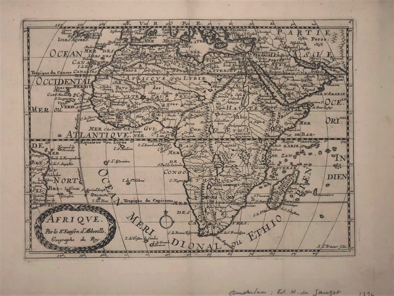
SANSON D'ABBEVILLE
AFRIQUE
Afrique par Sanson d’Abbeville (XVIIIe). 27,5 x 19,5 cm. Gravure sur cuivre publié dans; "Atlas Portatif composé de CCLXXXV cartes (...) Edité par Henri du Sauzet. Amsterdam 1734
Bookseller reference : PHO-417
|
|
|
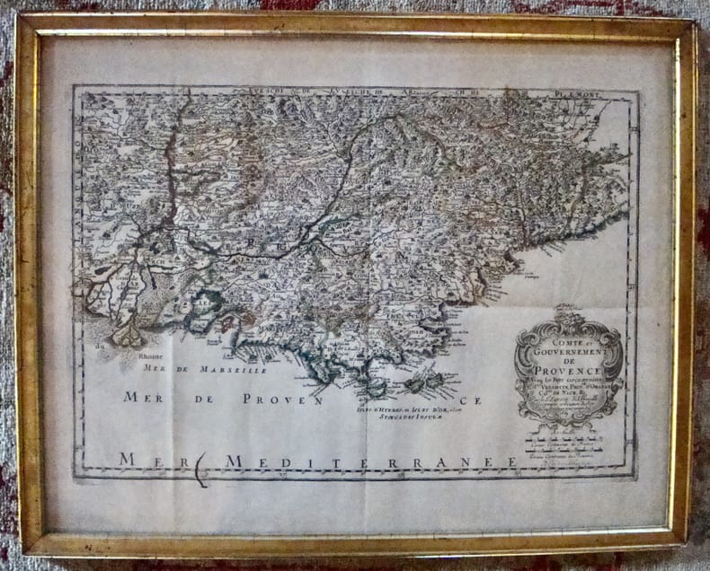
Sanson d'Abbeville
Comté et Gouvernement de Provence. Aveq les pays circonvoisins Comtat Venaiscin, Principauté d'Orange, Comtat de Nice, etc.
À Paris chez l'autheur. Encadré Très bon Paris 1669 1669 44 x 55 cm avec son cadre ancien.
Bookseller reference : 7613
|
|
|
SANSON d'ABBEVILLE (Nicolas) & COVENS (Jean) & MORTIER (Pierre).
Romani imperii qua occidens est, descriptio geographica.
Amsterdam, J. Covens et C. Mortier, [circa 1720]. 400 x 501 mm.
Bookseller reference : LBW-464
|
|
|
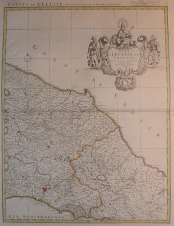
SANSON d'ABBEVILLE (Nicolas) & COVENS et MORTIER.
[TOSCANE/ETATS DE L'EGLISE] Estats de l'Eglise et de Toscane.
Amsterdam, Covens et Mortier, [circa 1710]. 580 x 445 mm.
Bookseller reference : LBW04176
|
|
|
SANSON d'ABBEVILLE (Nicolas) & JAILLOT (Alexis-Hubert).
[CATALOGNE] Principauté de Catalogne où sont compris les comtés de Roussillon et de Cerdagne divisés en leurs vigueries.
Paris, H. Jaillot, 1696. En deux feuilles jointes formant une carte de 565 x 868 mm.
Bookseller reference : LBW-6394

|
|
|
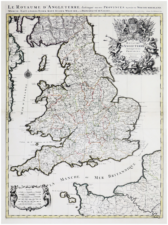
SANSON d'ABBEVILLE (Nicolas) & JAILLOT (Alexis-Hubert).
Le Royaume d'Angleterre distingué en ses provinces.
Paris, H. Jaillot, 1693. En deux feuilles jointes formant une carte de 785 x 584 mm.
Bookseller reference : LBW-6390
|
|
|
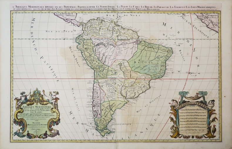
SANSON d'ABBEVILLE (Nicolas) & JAILLOT (Hubert).
Amérique méridionale divisée en ses principales parties où sont distingués les uns des autres les estats suivant qu'ils appartiennent présentement aux François, Castillans, Portugais, Hollandois, &c.
Paris, H. Jaillot, 1691. En deux feuilles jointes de 573 x 884 mm.
Bookseller reference : LBW-3673
|
|
|
SANSON d'ABBEVILLE (Nicolas) & SCHENK (Petrus).
[PAYS-BAS] Le cours de la rivière du Rhein depuis sa source jusques à son emboucheure où sont distingués toutes les estats et souverainetés.
Amsterdam, Pierre Schenk, [circa 1700]. 472 x 575 mm.
Bookseller reference : LBW0416f

|
|
|
SANSON d'ABBEVILLE (Nicolas) & TAVERNIER (Melchior).
[ROUTES des POSTES] Carte géographicque des postes qui traversent la France.
[Paris, Melchior Tavernier, 1632-1637]. 412 x 532 mm.
Bookseller reference : LBW-1373

|
|
|
SANSON d'ABBEVILLE (Nicolas).
[AFRIQUE MÉRIDIONALE] Basse Æthiopie qui comprend les royaume de Congo, coste, et pays des Cafres, empires du Monomotapa, et Monoemugi.
Paris, P. Mariette, 1655. 419 x 556 mm.
Bookseller reference : LBW-4533

|
|
|
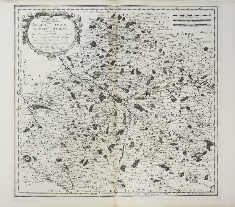
SANSON d'ABBEVILLE (Nicolas).
[AMIENS] Ambiani. Archid.conné d'Amiens, de l'évesché d'Amiens où sont les ball.ge et eslection d'Amiens.
Paris, P. Mariette, 1667. 394 x 411 mm.
Bookseller reference : LBW-3639
|
|
|
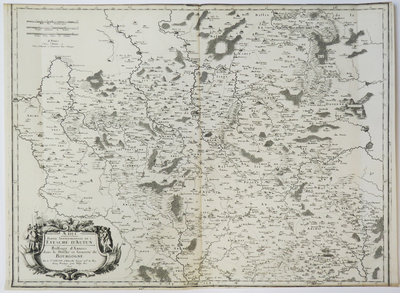
SANSON d'ABBEVILLE (Nicolas).
[AUXOIS] Ædui. Partie septentrionale de l'évesché d'Autun. Balliage d'Auxois dans le duché et gouvern. de Bourgogne.
Paris, chez l'auteur, 1659. 427 x 557 mm.
Bookseller reference : LBW-3641
|
|
|
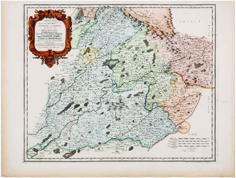
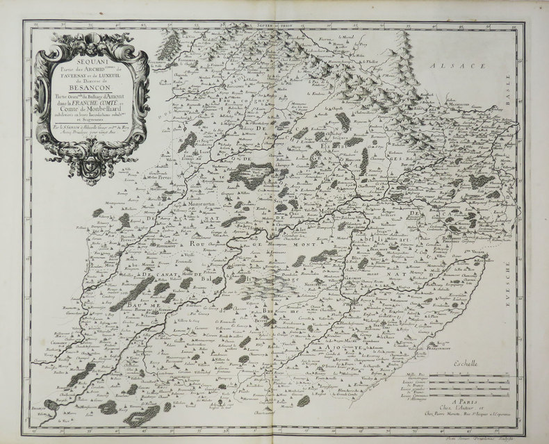
SANSON d'ABBEVILLE (Nicolas).
[BESANÇON/MONTBÉLIARD] Sequani. Partie des archid.connés de Favernay et de Luxeuil du diœcèse de Besançon. Partie orientale du balliage d'Amont dans la Franche Comté, et comté de Monbelliard.
Paris, chez l'auteur, 1679. 397 x 484 mm.
Bookseller reference : LBW-7225
|
|
|
SANSON d'ABBEVILLE (Nicolas).
[BLOIS & VENDÔME] Carnutes. Partie mérid.le de l'évesché de Chartres. Balliages de Blois et de Vendosme. Eslections de Chau-dun de Vendosme et de Blois.
Paris, P. Mariette, 1660. 411 x 564 mm.
Bookseller reference : LBW-3467

|
|
|
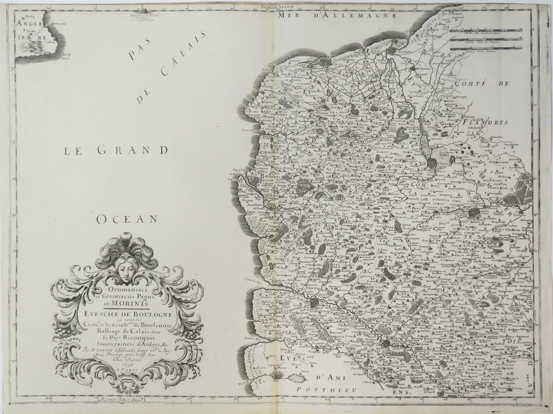
SANSON d'ABBEVILLE (Nicolas).
[BOULOGNE/MER] Oromansaci, et Gesoriacus Pagus in Morinis. Evesché de Boulogne où sont les comté et sénesch.ssée de Boulenois. Balliage de Calais dans le Pays Reconquis. Souveraineté d'Ardres, &c.
Paris, chez l'auteur, 1656. 415 x 550 mm.
Bookseller reference : LBW-3430
|
|
|
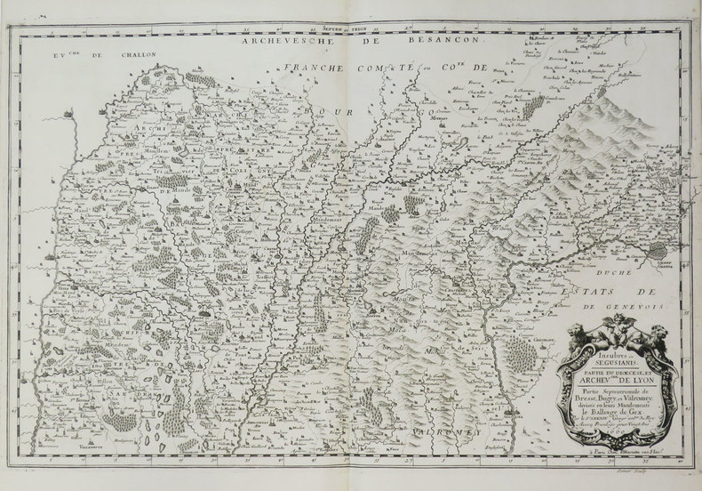
SANSON d'ABBEVILLE (Nicolas).
[BRESSE/BUGEY/VALROMEY] Insubres in Segusiani. Partie du diœcèse et archev.ché de Lyon. Partie septentrionale de Bresse, Bugey, et Valromey, divisée en leurs mandements. Le balliage de Gex.
Paris, P. Mariette, 1660. 354 x 555 mm.
Bookseller reference : LBW-3667
|
|
|
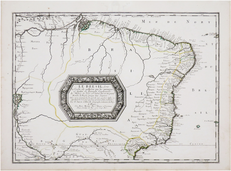
SANSON d'ABBEVILLE (Nicolas).
[BRÉSIL] Le Brésil, dont la coste est possédée par les portugais et divisée en quatorze capitanieries. Le milieu du pays est habité par un très grand nombre de peuples presque tous incogneus.
Paris, Pierre Mariette, 1656 [1658]. 394 x 542 mm.
Bookseller reference : LBW-7142
|
|
|
SANSON d'ABBEVILLE (Nicolas).
[CAMBRAI] Nervii. Diocèse de l'archevesché de Cambray : où sont les comté de Haynaut, le Cambrésis .
Paris, chez l'auteur, 1656. 420 x 552 mm.
Bookseller reference : LBW-5321

|
|
|
SANSON d'ABBEVILLE (Nicolas).
[CHILI] Le Chili divisé en ses treize jurisdictions.
Paris, Pierre Mariette, 1669. 395 x 446 mm.
Bookseller reference : LBW-6487

|
|
|
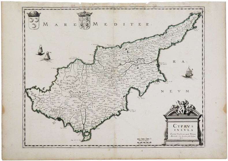
SANSON d'ABBEVILLE (Nicolas).
[CHYPRE] Cyprus insula.
Paris, Pierre Mariette, [1670]. 375 x 485 mm.
Bookseller reference : LBW-3262
|
|
|
SANSON d'ABBEVILLE (Nicolas).
[CONGO] Royaume de Congo, &c.
1656. 205 x 278 mm.
Bookseller reference : LBW0418e

|
|
|
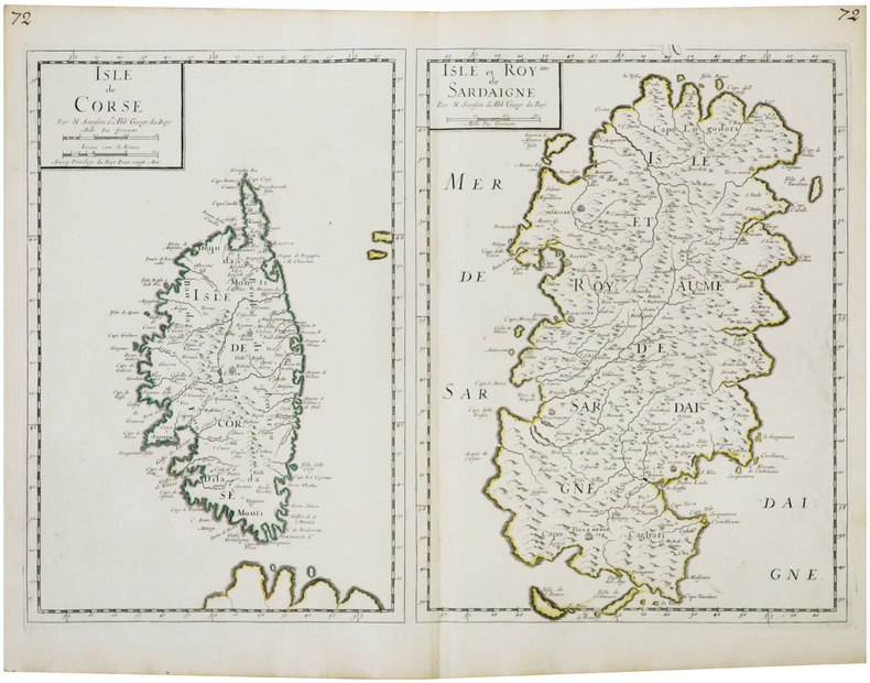
SANSON d'ABBEVILLE (Nicolas).
[CORSE & SARDAIGNE] Isle de Corse - Isle et Royme de Sardaigne.
Paris, chez l'auteur, [1658]. 390 x 555 mm.
Bookseller reference : LBW-7393
|
|
|
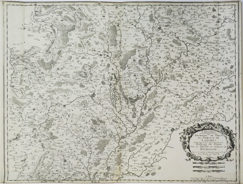
SANSON d'ABBEVILLE (Nicolas).
[DIJON] Lingones. Archidiac.né de Dijon, du diœcèse de Langres. Balliage de Dijon dans le duché et gouvern. de Bourgogne.
Paris, chez l'auteur, 1658. 435 x 562 mm.
Bookseller reference : LBW-3497
|
|
|
SANSON d'ABBEVILLE (Nicolas).
[FRANCHE-COMTÉ/BESANÇON] Sequani. Partie du diœc. et arch.ché de Besançon où sont les gr. archidiac.né, et celuy de Gray &c. Partie de la Franche Comté où est le balliage de Dole.
Paris, chez l'auteur, 1658. 403 x 573 mm.
Bookseller reference : LBW-3423

|
|
|
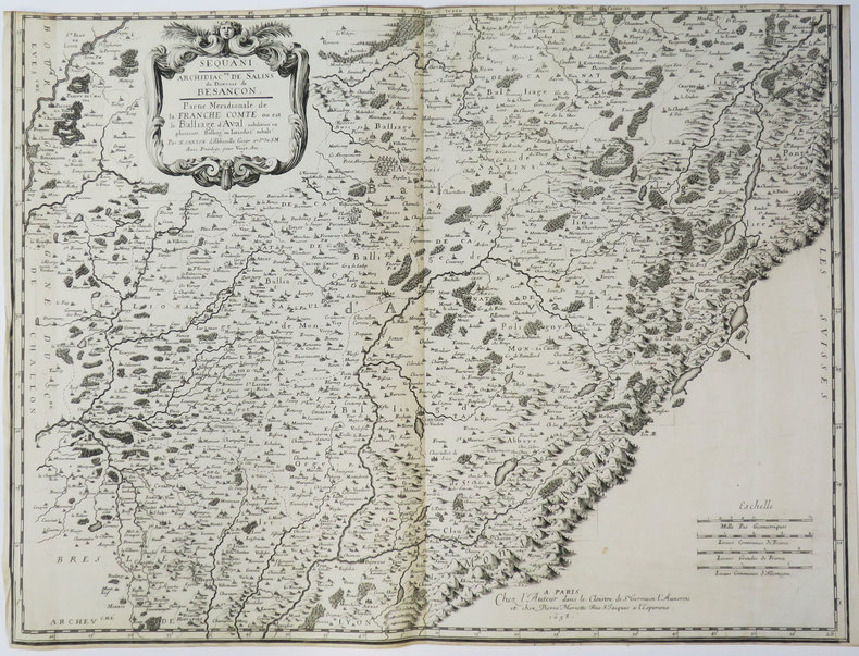
SANSON d'ABBEVILLE (Nicolas).
[FRANCHE-COMTÉ] Sequani. Archidiac.né de Salins du diœcèse de Besançon. Partie méridionale de la Franche Comté où est le balliage d'Aval.
Paris, chez l'auteur, 1658. 427 x 565 mm.
Bookseller reference : LBW-3648
|
|
|
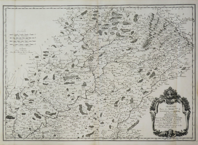
SANSON d'ABBEVILLE (Nicolas).
[FRANCHE-COMTÉ] Sequani. Partie des archid.connés de Favernay et de Luxeuil du diœcèse de Besançon. Partie occid.tale du balliage d'Amont dans la Franche Comté.
Paris, chez l'auteur, 1658. 397 x 560 mm.
Bookseller reference : LBW-3419
|
|
|
SANSON d'ABBEVILLE (Nicolas).
[FRANCHE-COMTÉ] Sequani. Partie des archid.connés de Favernay et de Luxeuil du diœcèse de Besançon. Partie orientale du balliage d'Amont dans la Franche Comté, et comté de Monbelliard.
Paris, chez l'auteur, 1658. 396 x 483 mm.
Bookseller reference : LBW-3669
|
|
|
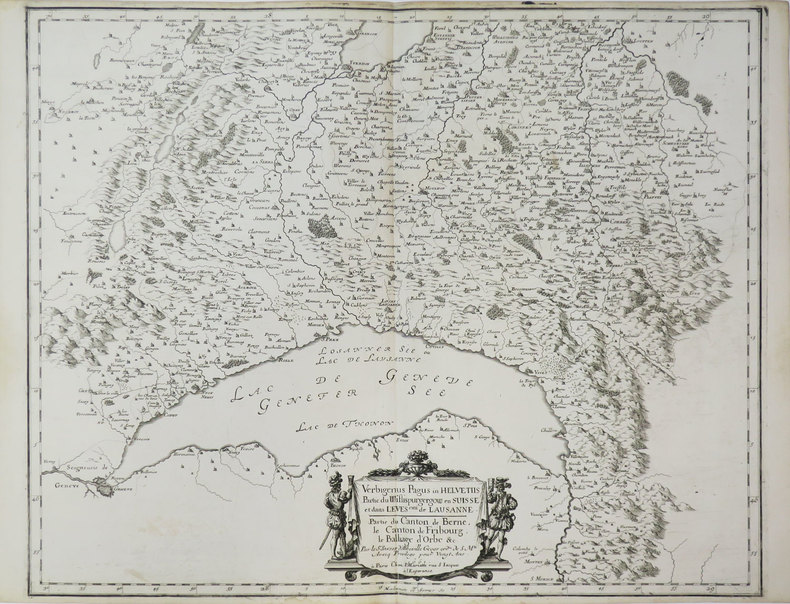
SANSON d'ABBEVILLE (Nicolas).
[LAC LÉMAN] Verbigenus Pagus in Helvetiis. Partie du Wiflispurgergow en Suisse et dans l'évesché de Lausanne. Partie du canton de Berne, le canton de Fribourg, le balliage d'Orbe &c.
Paris, P. Mariette, 1661. 418 x 521 mm.
Bookseller reference : LBW-3670
|
|
|
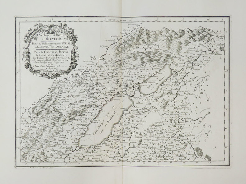
SANSON d'ABBEVILLE (Nicolas).
[LACS de NEUCHÂTEL et de BIENNE] Verbigenus Pagus in Helvetiis. Partie du Wiflisburgergow en Suisse et dans l'évesché de Lausanne. Partie du canton de Berne, le comté de Neufchastel, les balliages de Murat, de Granson &c.
Paris, P. Mariette, 1661. 297 x 424 mm.
Bookseller reference : LBW-3671
|
|
|
SANSON d'ABBEVILLE (Nicolas).
[LYON/SAINT-CHAMOND/MONTBRISON] Segusiani. Partie du diœ.se et archev.ché de Lyon. Le Lyonnois et le Haut Forez.
Paris, chez l'auteur, 1659. 412 x 531 mm.
Bookseller reference : LBW-3666

|
|
 Receive by email
 Download as PDF document
 RSS feed


