|
Sanson Henri Clement
Mémoires des Sanson: Tome 4 French Edition
paperback. Good. Access codes and supplements are not guaranteed with used items. May be an ex-library book. paperback
Riferimento per il libraio : 0543952614.G ISBN : 0543952614 9780543952615
|
|
|
Sanson Henry
Tagebücher der Henker von Paris German Edition
paperback. Good. Access codes and supplements are not guaranteed with used items. May be an ex-library book. paperback
Riferimento per il libraio : 3861957884.G ISBN : 3861957884 9783861957881
|
|
|
Sanson Hippolyte
Contribution À l'Étude de la Laparotomie Rectale French Edition
paperback. Good. Access codes and supplements are not guaranteed with used items. May be an ex-library book. paperback
Riferimento per il libraio : 2329147546.G ISBN : 2329147546 9782329147543
|
|
|
Sanson J
Service de l'Administration Des Vaisseaux Du Roi Ou Recueil Des Lois Ordonnances Et Instructions: Qui Régissent Les Différentes Parties de la . Justice Sciences Sociales French Edition
paperback. Good. Access codes and supplements are not guaranteed with used items. May be an ex-library book. paperback
Riferimento per il libraio : 2019598485.G ISBN : 2019598485 9782019598488
|
|
|
Sanson Joseph
Hope and Ambition
paperback. Good. Access codes and supplements are not guaranteed with used items. May be an ex-library book. paperback
Riferimento per il libraio : 3337090664.G ISBN : 3337090664 9783337090661
|
|
|
Sanson Judith
A Blossom from a Barnyard
paperback. Good. Access codes and supplements are not guaranteed with used items. May be an ex-library book. paperback
Riferimento per il libraio : 0595167608.G ISBN : 0595167608 9780595167609

|
|
|
Sanson Kerry
THE BOOK OF HEALTH HACKS: Applying Simple Daily Habits To Feel Less Blah And More Hurrah!
new. unknown
Riferimento per il libraio : 44896698-n ISBN : 1839525746 9781839525742
|
|
|
Sanson Kerry
THE BOOK OF HEALTH HACKS: Applying Simple Daily Habits To Feel Less Blah And More Hurrah!
Brown Dog Books. Hardcover. Used; Good. Simply Brit welcome to our online used book store where affordability meets great quality. Dive into a world of captivating reads without breaking the bank. We take pride in offering a wide selection of used books from classics to hidden gems ensuring theres something for every literary palate. All orders are shipped within 24 hours and our lightning fast-delivery within 48 hours coupled with our prompt customer service ensures a smooth journey from ordering to delivery. Discover the joy of reading with us your trusted source for affordable books that do not compromise on quality. 11/03/2022 Brown Dog Books hardcover
Riferimento per il libraio : 4085449 ISBN : 1839525746 9781839525742
|
|
|
Sanson Larry D.
Proceedings the Institute of Electrical and Electronics Engineers 30th Annual 1996 International Carnahan Conference on Security Technology : October 2-4 1996 Lexington Kentucky USA
New York City: IEEE 1996. Book. Very Good. Hardcover. 4to - over 9¾" - 12" tall. Hardcover 1996 edition. Ex-library book with stamps and labels attached. Binding firm. Pages unmarked and clean. Covers and text in very good condition. 256 p. : ill. ; 28 cm. IEEE Hardcover
Riferimento per il libraio : 010533 ISBN : 0780335384 9780780335387
|
|
|
Sanson Louis Joseph
Des Hémorrhagies Traumatiques Sciences French Edition
paperback. Good. Access codes and supplements are not guaranteed with used items. May be an ex-library book. paperback
Riferimento per il libraio : 2012465773.G ISBN : 2012465773 9782012465770
|
|
|
Sanson Marie
Induction de l'expression de OPR150 par les LDL oxydées: ORP150 protège les cellules endothéliales de l'apoptose dans un contexte d'athérosclérose French Edition
paperback. Good. Access codes and supplements are not guaranteed with used items. May be an ex-library book. paperback
Riferimento per il libraio : 3838178408.G ISBN : 3838178408 9783838178400

|
|
|
Sanson Marie Editor Jean Cocteau
Maison Jean Cocteau
Paris: Somogy 2010. First edition. Paperback. Fine. Thick paperbound volume in photo-illustrated glossy wrappers with French flaps. 103 pp. Illustrated with numerous illustrations and color photographs. Text in French by Pierre Berge and others. A fine copy. Book describes and analyzes the life and career of author and artist Jean Cocteau in his home in France. Somogy paperback books
Riferimento per il libraio : 29856

|
|
|
SANSON N
L'Isle de la Martinique
Paris 1667. No Binding. Near Fine. 12 ½ x 17 inches. Original outline color; excellent. Earliest map of Martinique listed in Phillips featuring attractive original color and an elegant cartouche. This map depicts the situation on the island before 1660 when it was still largely inhabited by natives and only about half of it had been claimed by colonists for sugar cane farming. The map goes so far as to mark with a printed line the partition dividing the "demeure des François" and the "demeure des savages." However by 1660 the entirety of the native population was either dead expelled or in slavery and Martinique was a full-fledged sugar cane-farming European colony. Phillips Maps P. 389. unknown books
Riferimento per il libraio : 10027
|
|
|
SANSON Nicolas
Carte Particuliere de la Caroline dresse sur les Memoires le plus Nouveaux. Par le Sieur S
Amsterdam: Pierre Mortier 1696. Engraved broadside map 19 x 23 5/8 inches plate mark dimensions with extensive pink and green wash. Some light browning but an attractive copy. Matted glazed and framed. One of two issues of this map this one being a bit larger based on the Thornton-Morden map of circa 1685. Pictures the colony from the Santee River to the South Edisto River and well inland up the Cooper River. Physical features and names of plantation and land owners are given in English "Nouveau Londre" on the Edistow sic River being exceptions; soundings are given at river mouths in Charleston Harbor and in the ocean along some beaches. Cumming Southeast in Early Maps 121. Kendall Early Maps of Carolina 17c: "This map has a wealth of names of owners of land in Carolina. Pierre Mortier unknown
Riferimento per il libraio : 48399
|
|
|
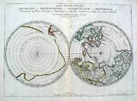
Sanson Nicolas. Antarctic & Arctic Map
Les Deux Poles Septentrional et Meridional ou Description des Terres Arcticques et Antarctiques; et des Pays circomvoisins jusques aux 45 Degres de Latitude
Paris 1657. Par N. Sanson d'Abbeville Geographe ordre du Roy. Spence 3017 lists a slightly different title but undoubtedly the same map. 53x38 cms. Period outline color central fold very good condition. A double hemisphere map to the North and South poles. The North pole is connected to Greenland and Spitzbergen but there is little other detailed coastline in the polar area. Europe Russia and Canada are delineated. The South pole is based on the great unknown Southland of Magellan. The tip of S. America is shown and a large land mass which encompasses the whole of the hemisphere but nothing else. unknown
Riferimento per il libraio : 5033
|
|
|
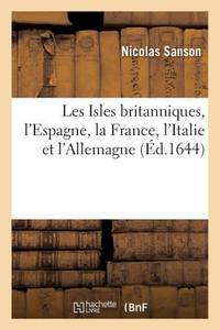
Sanson Nicolas
Les Isles Britanniques l'Espagne La France l'Italie Et l'Allemagne Histoire French Edition
paperback. Good. Access codes and supplements are not guaranteed with used items. May be an ex-library book. paperback
Riferimento per il libraio : 2016172509.G ISBN : 2016172509 9782016172506
|
|
|
SANSON Nicholas and Guillaume SANSON d. 1703
Amerique Septentrionale
Paris: Chez Pierre Mariette 1669. Copper-engraved map period hand colouring in outline. The most important French map of North America of its generation produced by the country's most esteemed family of cartographers.<br/> <br/>This very influential map was the official successor to Nicolas Sanson's 1650 map of North America. When Nicolas Sanson regarded as the father of the renaissance of cartography under Louis XIV died in July 1667 he left his flourishing business in the care of his eldest son Guillaume. The younger Sanson continued his father's partnership with the Mariette family who were prominent Parisian printers. Guillame was determined to publish a new updated edition of his father's Cartes Generales de toutes parties du Monde the first French general atlas originally published in 1657. The map of North America that appeared in the atlas although masterful was now considered to be geographically outdated. The present map which appeared in the second edition of the atlas featured updated toponymy and is geographically based on Nicolas Sanson's wall map of 1666 of which only two copies survive. While California is shown to be an island in line with popular perception unlike the map from 1650 it no longer attempts to build a geographical mythology in the place of the Pacific Northwest which was then totally unknown. Appropriately the magnificent baroque title cartouche which features swags and ribbons held aloft by putti has been placed to fill this enigmatic space. Cartographically the map appears to be based on Sanson's maps of "Le Canada ou Nouvelle France" and "Le Nouveau Mexique et La Floride." Lake Erie is shown in a recognizable form and the entire Great Lakes network is shown in greater detail than his father's map although the western lakes are still open-ended. On the East coast Long Island is shown and the shape of the Outer Banks is improved. Several Indian tribes are identified in New Mexico where the R. del Norte Rio Grande mistakenly flows from an interior lake and empties into the Mar Vermeio ou Mer Rouge Gulf of California. Iceland now appears in the Atlantic as well as a bit of Britain. The map proved to be highly successful and was sourced on numerous occasions by other mapmakers. The present copy is an example of Burden's first state of the map; a second state would be issued in 1690.<br/> <br/>Burden The Mapping of North America I 404; first state McCorkle New England in Early Printed Maps 669.4; McLaughlin California as an Island 45; Wagner Cartography of the Northwest Coast of America 399; Tooley "California as an Island" 8 in TooleyThe Mapping of America. Chez Pierre Mariette unknown books
Riferimento per il libraio : 25695

|
|
|
SANSON Nicholas and Guillaume SANSON d. 1703
Amerique Septentrionale
Paris: Chez Pierre Mariette 1690. Copper-engraved map period hand colouring in outline. Among the most important French maps of North America of the second half of the 17th century produced by the country's most esteemed family of cartographers.<br/> <br/>This very influential map was the official successor to Nicolas Sanson's 1650 map of North America. When Nicolas Sanson regarded as the father of the renaissance of cartography under Louis XIV died in July 1667 he left his flourishing business under the charge of his eldest son Guillaume. The younger Sanson continued his father's partnership with the Mariette family who were prominent Parisian printers. Guillame was determined to publish a new updated edition of his father's Cartes Generales de toutes parties du Monde the first French general atlas originally published in 1657. The map of North America that appeared in the atlas although masterful was now considered to be geographically outdated. The present map which appeared in the second edition of the atlas featured updated toponymy and is geographically based on Nicolas Sanson's wall map of 1666 of which only two copies survive. While California is shown to be an island in line with popular perception unlike the map from 1650 it no longer attempts to build a geographical mythology in the place of the Pacific Northwest which was then totally unknown. Appropriately the magnificent baroque title cartouche which features swags and ribbons held aloft by putti has been placed to fill this enigmatic space. Cartographically the map appears to be based on Sanson's maps of "Le Canada ou Nouvelle France" and "Le Nouveau Mexique et La Floride." Lake Erie is shown in a recognizable form and the entire Great Lakes network is shown in greater detail than his father's map although the western lakes are still open-ended. On the East coast Long Island is shown and the shape of the Outer Banks is improved. Several Indian tribes are identified in New Mexico where the R. del Norte Rio Grande mistakenly flows from an interior lake and empties into the Mar Vermeio ou Mer Rouge Gulf of California. Iceland now appears in the Atlantic as well as a bit of Britain. The map proved to be highly successful and was sourced on numerous occasions by other mapmakers. The present copy is an example of Burden's second state of the map with the date changed to 1690 in the cartouche and with additional place names and other changes: ".with minor alterations Terre de Jesso and Conibas inserted but without a coastline. Detroit d'Anian placed immediately above California and a few changes in spelling . New Albion is inserted in the north of the island and New York replaces New Amsterdam" Tooley.<br/> <br/>Burden The Mapping of North America 404 second state; McCorkle New England in Early Printed Maps 669.4; cf. McLaughlin California as an Island 45; cf. Wagner Cartography of the Northwest Coast of America 399; Tooley "California as an Island" 9 in TooleyThe Mapping of America. Chez Pierre Mariette unknown books
Riferimento per il libraio : 25648

|
|
|
Sanson Nicholas.
Le Royaume De France divise en Toutes fes Provinces…
<p>Copper engraved map double page 24" x 20" hand colored and large uncolored title cartouches. Some minor soiling a little wear along centerfold with old verso repair normal aging; very good. Samson 1600-1667 is often referred to as the father of French cartography. Louis XIII was impressed with his work and appointed him "Geographe Ordinaire du Roi". During his career Sanson would produce about 300 maps and his major atlas "Cartes Generales de Toutes les Parties du Monde" would represent an important part of his body of work. While two of his sons continued publication of his maps after his death Pieter Schenk 1655-1718 an important publisher and engraver in his own right published this map. The map is attractively colored and gives a detailed view of the provinces of France. The map is also decorated with a large title cartouche. Bagrow p. 185. map hist website.</p> books
Riferimento per il libraio : 104160

|
|
|
SANSON Nicolas
Antiquorum Africae Episcopatuum Geographica Descripto
Amsterdam: Mortier Pieter II 1723. unbound. very good. Map. Engraving with hand coloring. Image measures 14.5" x 19.25".<br/><br/> Includes parts of modern day Morocco Algeria Tunisia and Libya. Nicolas Sanson 1600-1667 is considered the founder of the French school of cartography. In reaction to the prevailing trend of Dutch lavishness Sanson favored minimal details focusing rather on accurate cartography than ornament. Large decorative title cartouche. Map is in good condition with ample margins. Staining along centerfold. Chipped near edges along centerfold.<br/><br/> Mortier, Pieter II unknown books
Riferimento per il libraio : 202384

|
|
|
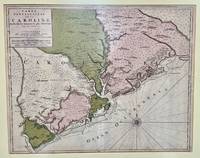
SANSON Nicolas
Carte Particuliere de la Caroline dresse sur les Memoires le plus Nouveaux. Par le Sieur S
Amsterdam: Pierre Mortier 1696. Engraved broadside map 19 x 23 5/8 inches plate mark dimensions with extensive pink and green wash. Some light browning but an attractive copy. Matted glazed and framed. One of two issues of this map this one being a bit larger based on the Thornton-Morden map of circa 1685. Pictures the colony from the Santee River to the South Edisto River and well inland up the Cooper River. Physical features and names of plantation and land owners are given in English "Nouveau Londre" on the Edistow sic River being exceptions; soundings are given at river mouths in Charleston Harbor and in the ocean along some beaches. Cumming Southeast in Early Maps 121. Kendall Early Maps of Carolina 17c: "This map has a wealth of names of owners of land in Carolina." <br/><br/> Pierre Mortier unknown books
Riferimento per il libraio : 48399
|
|
|
SANSON Nicolas
Champagne et Brie etc.
Paris: Nicolas Sanson. unbound. Map. Uncolored copper engraving. Image measures 15 3/4" x 19 3/4". c.1660.<br/><br/> This elegant circa 1660 map by Nicolas Sanson features the famous French winemaking region of Champagne and the cheese making region of Brie. It extends south from the regions of Picardie to Burgundy and from Isle de France east to Lorraine. The map notes several towns and rivers with beautifully rendered mountains and forests throughout. An engraved grape surround cartouche features cherubs on the top left and the bottom right scale is surrounded by cherubs with mapping tools. The map has a stain in the upper right margin with minor foxing and minimal wear along the centerfold. Minor edge wear.<br><br>Nicolas Sanson 1600-1667 is considered the founder of the French school of cartography. This map is a fine example of his work and a pleasure to see black and white.<br/><br/> Nicolas Sanson unknown books
Riferimento per il libraio : 269694

|
|
|
SANSON Nicolas
Colchis Iberia Albania quaeg; Caucasiae Gentes Isthum qui Pontum Euxinum Caspiumq; Mare Interjacet Incolunt
Amsterdam: Mortier Pieter 1723. unbound. very good. Map. Engraving with hand outline. Image measures 14" x 18.75".<br/><br/> Beautifully detailed map showing the area between the the Black and Caspian Seas including modern day Russia Georgia Azerbaijan Armenia and Turkey. Full original margins have minor stains. Based on the plates by Nicolas Sanson 1600-1667 who is considered the founder of the French school of cartography. In reaction to the prevailing trend of Dutch lavishness Sanson favored minimal details focusing rather on accurate cartography than ornament.<br/><br/> Mortier, Pieter unknown books
Riferimento per il libraio : 209708

|
|
|
SANSON Nicolas
Galatia cujus Populi Tolistobogi Tectosages Trocmi mox Provincia sub Romanis in Primam et Secundam divisa et in ea Romana Itineraria
Amsterdam: Pierre Mortier. unbound. very good. Map. Engraving with hand outline. Image measures 13 11/16" x 22 3/8".<br/><br/> Rare map of northern Turkey centered around Ankara circa 1700. Minor scattered toning chipping to edges. Full original margins.<br/><br/> Pierre Mortier unknown books
Riferimento per il libraio : 215370

|
|
|
Sanson Nicolas
In Pharum Galliae antiquae Philippi Labbe Biturici & Societatis Iesu Sacerdotis disquisitiones geographicae : in quibus ad singula omnium locorum nomina aut furti sive plagii aut falsi sive erroris arguitur Philip. Labbe
Lutetiae Parisiorum: Sumptibus & Impensis Autoris 1647. Hardcover. Good. 16mo. Old leather; quite worn. pp 16 246 2. Liber primus only. <br/><br/> Sumptibus & Impensis Autoris hardcover books
Riferimento per il libraio : WB16371
|
|
|
SANSON Nicolas
Indiae extra Gangem Pars Septentrionalis. Indiae extra Gangem Pars Meridionalis
Paris 1680. unbound. Map. Uncolored copper plate engraving. Image measures 7.5" x 10". 1680.<br/><br/> This map of southeast Asia and the East Indies is essentially two maps on a single sheet. The map on the left depicts the northern portion of the India Ganges region representing Burma Myanmar Thailand Cambodia Vietnam and Laos while the map of the right depicts the southern portion and includes the Malay Peninsula Singapore Sumatra. The most interesting feature is the Lacus Chimay Chimay Lake the mythical lake located in northern Burma which was believed to be the source of the river system in Southeast Asia. Important towns and cities are identified with beautifully rendered topography depicted in profile. Map is in very good condition with some toning along original centerfold which shows repairs on verso. Minimal foxing. <br><br>Nicolas Sanson 1600-1667 is considered the founder of the French school of cartography. In reaction to the prevailing trend of Dutch lavishness Sanson favored minimal details focusing rather on accurate cartography than ornament. This map is a fine example of his work.<br/><br/> unknown books
Riferimento per il libraio : 264415

|
|
|
SANSON Nicolas
Isle et Royaume de Sicile
Paris 1663. unbound. very good. Map. Hand-colored engraving. 15" x 23".<br/><br/> This map of Sicily from the 17th century shows the entire island as well as the southwesternmost tip of the Italian peninsula. The names of the surrounding bodies of water are named in Latin and rivers mountains lakes and towns are noted on the map. Nicolas Sanson 1600-1667 is considered the founder of the French school of cartography. In reaction to the prevailing trend of Dutch lavishness Sanson favored minimal details focusing rather on accurate cartography than ornament. This map is a fine example of his work.<br/><br/> unknown books
Riferimento per il libraio : 283501

|
|
|
Sanson Nicolas
L'Afrique en Plusieurs Cartes Nouvelles et Exactes; & en Divers Tractes de Geographie et d'Histoire. . . .
Paris: Chez l'Autheur 1656. First Edition . Full Calf. Very Good. 4to. 23.5 by 17.5 cm. Unpaginated 100 pages of text plus 2 pp. of ads. With 18 copper engraved maps all two page plates each with hand-colored of boundaries. Maps include one of the entire continent then of its various regions as then known plus the islands off the continent. Also a map of Malta. Bound in contemporary calf. Condition: calf dry and rubbed on spine and joints and edges rubbed. Light to moderate soiling in the margins of the pages. Two bookplates -- one of the Marquis of Lothian the other the Newbattle Abbey Library. <br /><br /> Chez l'Autheur books
Riferimento per il libraio : 006682

|
|
|
Sanson Nicolas
L'Asie en Plusieurs Cartes Nouvelles et Exactes; & en Divers Tractes de Geographie et d'Histoire. . . .
Paris: Chez l'Autheur 1652. First Edition . Full Calf. Very Good. 4to. 23.5 by 17.5 cm. Unpaginated 102 pages of text plus 2 pp. of ads 1 Royal privilege page. With 17 copper engraved maps all two page plates each with hand-colored of boundaries. Maps include one of the entire continent then of its various regions as then known plus island groups. Separate maps for China and Japan. Bound in contemporary calf. Condition: Rebacked with joints making this obvious. Calf dry and rubbed on spine and joints and edges rubbed. Light to moderate soiling in the margins of the pages. Edge of a few leaves with short stretch slightly chewed-looking. Two bookplates -- one of the Marquis of Lothian the other the Newbattle Abbey Library. <br /><br /> Chez l'Autheur books
Riferimento per il libraio : 006683

|
|
|
Sanson Nicolas
L'Hydrographie Ou Description De L'Eau C'Est a Dire Des Mers Golfes Lacs Destroits Et Rivieres Principales Qui Font Dans La Surface Du Globe Terrestre
Paris: Sanson. Very Good. 1652. A very rare map from Nicolas Sanson. Imprint bears the date of 1652 although it is possible that this copy came from an atlas in the later 1600s. Light toning and edgewear with one corner slightly chipped. Light soil on lower margin. Hand-colored boundaries. Map borders measure 14" x 20 3/4". California is shown as an island and Terre Australe is a vague line encircling the Antarctic. Terre de Iesso is the name given to the land mass northwest of North America. Sanson 1600-1667 published many map versions of the world and is known as "the father of French cartography." ; 16 1/2" x 22 1/4" . Sanson unknown books
Riferimento per il libraio : 010748tw

|
|
|
SANSON Nicolas
L'Hydrographie ou Description de l'Eau; c'est a dire des Mers Golfes Lacs Destroits et Rivieres principales qui font dans la Surface du Globe Terrestre
Abbeville: Nicolas Sanson 1652. unbound. Map. Engraving with original outline hand coloring. Image measures 15 1/2" x 20 1/2". Shows light foxing and some mat burn.<br/><br/> A beautiful and unususual double hemisphere hydrological world map from the mid 17th century. Shows and highlights all bodies of water including oceans gulfs lakes straits and rivers. Wonderful light hachure marks hint of a land mass in Terre Australe. Nicolas Sanson 1600-1667 is considered the founder of the French school of cartography. In reaction to the prevailing trend of Dutch baroque design Sanson favored minimal details focusing rather on accurate cartography than ornament. Shirley R.W. World 394<br/><br/> Nicolas Sanson unknown books
Riferimento per il libraio : 287521

|
|
|
SANSON Nicolas
Le Gouvernement General du Dauphine et des pays circonvoisins ou sont la Savoye la Bresse
Paris 1652. unbound. Map. Engraving with hand outline color. Image measures 14 x 16.5%u201D.<br/><br/> This map of southeastern France includes the erstwhile provinces of Dauphiné corresponding roughly to the present departments of Isère Drôme and Hautes-Alpes as well as parts of Savoye and Bresse. At the time of the map%u2019s publication in 1652 Dauphiné was under the absolutist rule of King Louis XIV. The cartographer Nicolas Sanson as Royal Geographer to Louis XIV as well as Louis III likely understood the importance of this region to French interests of the time. The map thusly provides ample detail about the area including cities rivers mountains and significant forts. Hand-colored outlines indicate political boundaries. An elegant cartouche in the upper right corner of the map displays the title amidst scrollwork topped with the crown of the French monarchy. The map is in very good condition with full margins and no chips or tears. Nicolas Sanson 1600-1667 is considered the founder of the French school of cartography. In reaction to the prevailing trend of Dutch lavishness Sanson favored minimal details focusing rather on accurate cartography than ornament. This map points to his significant role within the French monarchy.<br/><br/> unknown books
Riferimento per il libraio : 251161

|
|
|
SANSON Nicolas
Les Suisses les Allies des Suisses et leurs Suiets; qui peuvent passer Sous le mon de Suisses. Partie de Souabe &c
Paris 1648. unbound. Map. Engraving with hand outline color. Image measures 14.5 x 21.5 inches.<br/><br/> This map of Switzerland centers on Lucerne covering approximately the area from Lake Constance south to Lake Como in Italy. Published in 1648 the map dates to the period of the Old Swiss Confederacy. Furthermore it predates by only a few years the Swiss Peasant War of 1653 a siege of Lucerne and Bern that demonstrated the significance of the rural population to the confederacy%u2019s stability. Hand-colored outlines on the map indicate the various independent states that made up the confederacy. A title cartouche with elaborate scrollwork adorns the lower right corner of the map. The map is in good condition with full margins and no chips or tears. Wear to lower margin. Nicolas Sanson 1600-1667 is considered the founder of the French school of cartography. In reaction to the prevailing trend of Dutch lavishness Sanson favored minimal details focusing rather on accurate cartography than ornament. This map demonstrates the skill that made him such a valuable asset to the French monarchy.<br/><br/> unknown books
Riferimento per il libraio : 251162

|
|
|
SANSON Nicolas
Paphlagonia Heroicis Temporibus Henetorum Populorum sede Clara; cujus Paphlagonia Maritima suit Romanorum Aetate Ponti Regni Pars Occidentalior In qua Sinope.
Amsterdam: Mortier Pieter. unbound. very good. Map. Engraving with original hand outline. Image measures 14.5" x 18.75".<br/><br/> Beautiful and rare map of northern Anatolia in Turkey circa 1708. Detailed and animated cartouche. Paphlagonia is the ancient area along the southern coast of the Black Sea. Full original margins light scattered foxing. Based on earlier plates by Nicolas Sanson 1600-1667 who is considered the founder of the French school of cartography. In reaction to the prevailing trend of Dutch lavishness Sanson favored minimal details focusing rather on accurate cartography than ornament.<br/><br/> Mortier, Pieter unknown books
Riferimento per il libraio : 215454

|
|
|
SANSON Nicolas
Partie de Barbarie ou Sontles Royaumes de Tunis et Tripoli
Paris 1683. unbound. Map. Copper engraving with hand coloring. Image measures 7 5/8 x 11 1/4 inches.<br/><br/> This map published in Paris in Afrique en plusieurs cartes is one of Sanson's small atlas maps of depicting various African regions. This map offers extensive detail on the cities of North Africa as well as topographical and geographical features with mountains beautifully rendered in profile. Nicolas Sanson 1600-1667 is considered the founder of the French school of cartography. In reaction to the prevailing trend of Dutch lavishness Sanson favored minimal details focusing rather on accurate cartography than ornament. This map is a fine example of his work.<br/><br/> unknown books
Riferimento per il libraio : 297468

|
|
|
Sanson Ronald
O PODER DO AMOR: A SOLU��O PARA TUDO EST� EM VOC� Portuguese Edition
NEW. unknown
Riferimento per il libraio : BIB-NOV-15-2025-133707 ISBN : 9798792761499 9798792761

|
|
|
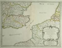
Sanson & Mortier
Le Gouvernement Général de Languedoc. Partie Occidentale. antique map of Languedoc
Amsterdam: Pierre Mortier 1742. A BEAUTIFUL HAND-COLORED MAP OF WESTERN LANGUEDOC and areas to the west and north. 60 x 45.5 cm plate 62 x 52 cm sheet. The areas described in the title are FULLY COLORED BY A CONTEMPORARY HAND. Printed on fine thick laid paper. Reverse blank. A fine impression. A PRISTINE EXAMPLE with the paper FINE AND BRIGHT. Very scarce in such fine condition. <br/><br/> Pierre Mortier unknown
Riferimento per il libraio : 38209
|
|
|
SANSON (Andre).
Les moutons. Histoire naturelle et zootechnie. Quatrième édition. Ouvrage orné de 56 gravures.
Paris Librairie agricole de la maison rustique 1885. VI. 168 pages. 48 pages. 12x185cm. Broché. Non rogné. Couverture imprimée. Couverture cassée. Manques. Mouillures. Salissures. Manques et déchirures au dos. Pages de texte en bon état. Paris, Librairie agricole de la maison rustique, 1885. unknown
Riferimento per il libraio : 101808

|
|
|
SANSON (J.).
La prévision du temps en agriculture. Avec 60 figures intercallées dans le texte. Encyclopédie agricole publiée par une réunion d'Ingénieurs agronomes sous la direction de G. Wery.
Paris Baillière et fils 1925. 320 pages. 185x12cm. Broché. Non coupé. Couverture imprimée éditeur. Accidents aux coiffes. Légères taches sur les plats. Intérieur bruni. Très bon état. Paris, Baillière et fils, 1925. unknown
Riferimento per il libraio : 105549

|
|
|
SANSON (J.)
Mémorial de la Météorologie Nationale. Recueil de données statistiques relatives à la climatologie de la France
Couverture rigide. Bon/1953. in-folio. Paris 1953 in-folio pet. XI 1bl 148pp 1 carte toile bleutée. Rel. de l'ép. Grande carte dépliante h.t. en couleur logée à l'intérieur du second plat représentant les précipitations annuelles de 1891 à 1930. Cachets gras d'une ancienne bibliothèque unknown
Riferimento per il libraio : 8874
|
|
|
SANSON (Nicolas).
Carte gÂŽographique : Provinces-Unies des Pays-Bas sÂavoir sic Le DuchÂŽ de Gueldre les ComtÂŽs de Hollande Zeelande ZÂŽlande Zutphen Les Seigneureries d'Utrecht Over-Issel Groningue et Ouest-Frise avec leurs acquisitions dans la Flandre le Brabant le Limbourg et le LyÂge LiÂge et les places qu'elles possÂŽdaient sur le Rhein Rhin dans le DuchÂŽ de ClÂves et dans l'ArchevÂchÂŽ et Electorat de Cologne.
1690. S.l. Alexis Hubert Jaillot 1680. Une grande carte 892 x 592 mm composÂŽe de deux feuillets contrecollÂŽs sous cadre moderne. Attractive 892 x 592 mm carte de la fin du XVIIÂme avec rehauts aquarellÂŽs du temps. Elle s'orne d'un important cartouche aux armes du Grand Dauphin Louis de France et s'agrÂŽmente en marge gauche de la figuration de vaisseaux ayant pris part ˆ un combat naval. Kupcik Cartes gÂŽographiques anciennes p. 159. Papier trÂs lÂŽgÂrement oxydÂŽ. PrÂŽsence de rares et claires rousseurs ou petites t‰ches. Deux plissures et une infime perforation en marge supÂŽrieure droite. Du reste belle condition. b42961 unknown
Riferimento per il libraio : 19294
|
|
|
SANSON (Nicolas).
In Pharum Galliae Antiquae Philippi Labbe Biturici et Societatis Jesu Sacerdotis Disquisitiones Geographicae in quibus ad singula omnium locorum nomina aut Furti sive Plagii aut Falsii sive Erroris arguitur Philip. Labbe. Lutetiae Parisiorum sumptibus et impensis Autoris 1647. RELIÉ AVEC à la suite: 2. DU MEME. In Pharum Galliae Antiquae Philippi Labbe Biturici et Societatis Jesu Sacerdotis Disquisitiones Geographicae in quibus ad singula omnium locorum nomina aut Furti sive Plagii aut Falsii sive Erroris arguitur Philip. Labbe. Liber Secundus. Lutetiae Parisiorum sumptibus et impensis Autoris 1647. RELIÉ AVEC à la suite: 3. DU MEME. Index Géographicus et Explicatio Regionum et Locorum omnium in Tabulae Iudae descriptionum.S.l. 1653 A la fin Paris Carolus Savreux 1653.
Paris Lutetiae Parisiorum Sumptibus et Impensis Autoris 1647. 3 ouvrages en 1 volume. 1. 2 feuillets blancs. 8 feuillets. 246 pages. 2. 13 feuillets. 283 pages. 3. 2 feuillets blancs. Page de titre. Carte gravée. 11 feuillets. 2 feuillets blancs. 15x9 Cm. Plein veau de l'époque. Dos à nerfs orné et doré un peu frotté. Pièce de titre doré. Charnières fendues. Petits accidents aux coiffes. Rousseurs et quelques taches. Les deux premiers ouvrages sont des critiques très rares du "Pharum Gallia Antiquae" de Philippe Labbé que Sanson rectifie sur plusieurs points. À la suite on trouve une courte description de la Judée accompagnée d'une belle carte dépliante. Bon exemplaire comportant l'exlibris gravé d'Henri Liébaux. Paris, Lutetiae Parisiorum Sumptibus et Impensis Autoris, 1647. unknown
Riferimento per il libraio : 48297
|
|
|
Sanson (P.).
Douleur Maîtresse de Vie.
Paris, Flammarion, 1937. Une plaquette de format in 8° de 48 pp. bon état. Peu courant.
|
|
|
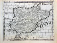
SANSON (Posiblemente)
Antiguo Grabado Mapa - Old Engraving Map : ESPAGNE
1738. Buen estado. Paris 1 lámina 13x16 cm márgenes sin enmarcar unknown
Riferimento per il libraio : 147571
|
|
|
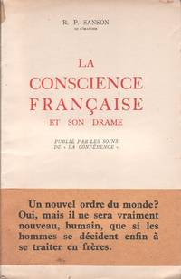
SANSON (R. P.)
La conscience française et son drame.
Editions Desclée de Brouwer 1941. Paperback. <b>Livre en français</b>. Couverture souple. Publié par les soins de ""la Conférence"". Broché. 54 pages. Avec son bandeau de librairie. <i>ref. 129826</i> Editions Desclée, de Brouwer paperback
Riferimento per il libraio : 129826
|
|
|
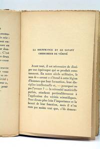
SANSON (R. P.).
La Souffrance et nous.
Paris Flammarion 1933. 223 pages. 1 feuillet. 19x12 Cm. roché. Couverture imprimée. Rousseurs. Accrocs. Mouillures. Plis. Écrit en 1933 ce livre invite à une profonde méditation sur la souffrance phénomène universel et intemporel qui touche l'existence humaine sous des formes multiples. À travers ce texte il explore les dimensions psychologiques morales et surtout spirituelles de la souffrance offrant au lecteur une approche éclairée par une foi ancrée probablement catholique qui cherche à transcender la douleur en un chemin de sens et d'espérance. Cette œuvre accessible et chaleureuse mêle philosophie et spiritualité sans éluder la réalité crue des souffrances humaines rendant le sujet à la fois proche et universel. Exemplaire usé. Importante mouillure dans la dernère partie du livre. Paris, Flammarion, 1933. unknown
Riferimento per il libraio : 119926
|
|
|
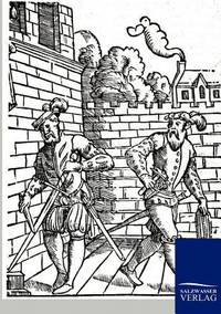
Sanson - Pol Andre
Mémoires de Sanson Exécuteur des Jugements Criminels
Couverture rigide. Bon/sd. in-8. Paris sd in-8 390pp broché Quelques défauts mineurs sinon très bel exemplaire! unknown
Riferimento per il libraio : 34930
|
|
|
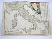
Sanson - Vaugondy
L'Italieet ses Isles circonvoisines Sicile Sardaigne Corse & exactement divisees en leurs Etats Royaumes Republiques
Paris: Delamarche 1778. Very Good. Size : 515x685 mm 20.25x27 Inches Coloring: Original Outline Coloring Category: ; Maps Europe Italy Delamarche unknown
Riferimento per il libraio : M3888
|
|
|
SANSON [D'ABBEVILLE, Nicolas].
Anciens Royaumes De Kent D'Essex et De Sussex ou sont Aujourdhuy les Comtés Kent D'Essex Middlessex Et Hartford De Sussex Et Surrey. Avecq le Pas De Calais et Partie des Costes du Pays Bas de Picardie et Normandie.
Paris: Sanson. 1654. 36.6 x 48 cm. Original outline colour. Double page map of the south east England shown with the adjacent coastline of France and Belgium. Title cartouche to lower right corner. Blank on verso. Wear to centrefold with some small holes. Paris: (Sanson). 1654 unknown
Riferimento per il libraio : 28812
|
|
|
Sanson AJ
Les Vrais Principes De La Navigation Aerienne Ou L'enigme De L'annee 1839 D'evoilee;
Paris: Chez L'un des Auteurs et Chez Ledoyen Libraire 1852. 1st. Very Good. 1st edition. Pamphlet in original wraps bound in limp paper covered boards. A beautiful copy. <br/><br/> Chez L'un des Auteurs et Chez Ledoyen Libraire hardcover books
Riferimento per il libraio : 8000
|
|
 Ricevere i risultati per e-mail
 Scaricare i risultati in PDF
 RSS feed


