|
Erik Orsenna
Le Bois des Moutiers
France: SCI La Haie des Moutiers 2007. First Edition. Softcover. Very Good. Holland Brady Jr. is a highly reputed architect from Tryon a small upscale community in the mountains of North Carolina. Brady accumulated a quality library of over 2400 architecture books. This book is from that collection which we purchased. Please remember that if you purchase multiple architecture books we combine shipping. Gift inscription on inside front cover. SCI La Haie des Moutiers paperback
书商的参考编号 : 016737
|
|
|
Erik Raikula
Tallinn First Edition
1975. First Edition. Hardcover. Near Fine/Near Fine. Illustrated. Illustrated cloth. Pictorial dust jacket. Profusely illustrated. Written in two languages. Previous owner's library bookplate on front free end-paper. No writing in the book. 151pp. Full refund if not satisfied. hardcover
书商的参考编号 : 026551
|
|
|
Eriksen Svend
Early Neo-Classicism in France
London: Faber & Faber Ltd 1974. Hardcover no jacket in good condition. Translated from the Danish and edited by Peter Thornton. External edgewear and fading most notably on the edges and spine. Minor marks on the page block. Name of previous owner penned on the opening blank page; pages thereafter are clean. The binding is sound; text and images are clear. CM. Hardcover. Good. Used. Faber & Faber Ltd Hardcover
书商的参考编号 : 492427 ???????? : 0571087175 9780571087174

|
|
|
Eriksen, Svend
Waddesdon Manor: The James A. De Rothschild bequest to the National Trust - a Guide to the House and Its Contents
80 pages, illustrated, plans. eng
|
|
|
Eriksen, Svend
Waddesdon Manor: The James A. De Rothschild Bequest to the National Trust: A Guide to the House and Its Contents
70 pages, illustrated, plans, index of artists and craftsmen, March 1970 supplement to the guide book by Mary Brassey loosely inserted. eng
|
|
|
Eriksen, Svend
Waddesdon Manor: The James A. De Rothschild Bequest to the National Trust: A Guide to the House and Its Contents
80 pages, illustrated, plans, back cover dusty. eng
|
|
|
Erim, Kenan T. (Introduction by John Julius Norwich)
APHRODISIAS City of Venus Aphrodite
One corner bumped else minor shelfwear. DJ has scratches to spine. Light chipping to head of DJ spine. ; Aphrodisias was the Florence of the Roman world ... It vanished from history in an earthquake in the fourth century AD and its temples, palaces, amphitheatres, statues and archives slept unplundered until rediscovered only forty years ago. The author is in charge of the dig which annually reveals architectural and artistic marvels, chronicled and pictured in this book. ; 4to 11" - 13" tall; 224 pages; Extra charges for shipping may apply.
|
|
|
Erim, Kenan T. (Introduction by John Julius Norwich)
APHRODISIAS City of Venus Aphrodite
DJ has minor edgewear near top of spine. DJ has minor rubbing. Book has minor bump to upper front corner. ; Aphrodisias was the Florence of the Roman world ... It vanished from history in an earthquake in the fourth century AD and its temples, palaces, amphitheatres, statues and archives slept unplundered until rediscovered only forty years ago. The author is in charge of the dig which annually reveals architectural and artistic marvels, chronicled and pictured in this book. ; 4to 11" - 13" tall; 224 pages; Extra charges for shipping may apply.
|
|
|
Erim, Kenan T. (Introduction by John Julius Norwich)
APHRODISIAS City of Venus Aphrodite
Corners have minor bumping else minor shelfwear. DJ has light edgewear. Light chipping to base of DJ spine. ; Aphrodisias was the Florence of the Roman world ... It vanished from history in an earthquake in the fourth century AD and its temples, palaces, amphitheatres, statues and archives slept unplundered until rediscovered only forty years ago. The author is in charge of the dig which annually reveals architectural and artistic marvels, chronicled and pictured in this book. ; 4to 11" - 13" tall; 224 pages; Extra charges for shipping may apply.
|
|
|
Erin Moore
Sisters Mobile Artist Studios
University of Oregon 2011. Paperback. Very Good. VG pictorial softcover. Bump to head of spine w/very short nick to cover. Light edgewear. Pages all clean/unmarked. Covers bright and clean. Photos/diagrams throughout. A fascinating and scarce book about architectual designs for various Mobile artist studios set in Sisters Oregon. "Students in the Architecture dept. at the University of Oregon were invited by the Roundhouse Foundation to develop Research and proposals for Live/work artist studios to be installed Temporarily around Sisters Oregon to foster arts-based economic development in this high desert region." 139 pp. <br/><br/> University of Oregon paperback
书商的参考编号 : A17902 ???????? : 0615736017 9780615736013

|
|
|
ERIXON, S
Skansens kulturhistoriska avdelning. Vägledning för besökande. 2. Aufl.
Stockholm, Nordiska Museets Förlag, 1927. 201, (1) S. m. 116 Abb.; 10 Bl. Anzeigen (davon 1 mehrf. gefaltet). OBr. (Kopf m. kl. Fehlstelle, Umschl. im Falz m. Einrissen, lichtrandig u. etwas braunfleckig).
书商的参考编号 : 1305437
|
|
|
ERIXON, SIGURD (utg.).
Byggnads-Kultur.
Sth.,Oslo, K., 1953. Lex8vo. 416 pp., illustr. (Nord.Kultur).
|
|
|
ERKINS Henry
NEW YORK PLAISANCE. Number One MDCCCCVIII, an Illustrated Series of New York Places of Amusement
New York New-York-Plaisance (Rogers & Company, Chicago and New-York) 1908 in 4 (32x23,5) 1 volume reliure toilée ornée de l'éditeur, non paginé (unpaged), avec de nombreuses illustrations, dont planches hors-texte contrecollées, avec 22 pages de publicités in fine. Contains illustrated interiors of the New Amsterdam Theatre designed by Herts & Tallant, and Murray's Restaurant in New York City designed by Henry Erkins. First Edition. Bel exemplaire ( Photographies sur demande / We can send pictures of this book on simple request )
书商的参考编号 : 37866
|
|
|
ERKUT SAHINBAS, (1936- ).
Erkut Sahinbas. 1968-1998 Architectural works.= 1968-1998 Mimarlik çalismalari. Introduction by C. Abdi Güzer.
New English Paperback. 4to. (33 x 33 cm). In English and Turkish. 243 p., color and b/w ills. Erkut Sahinbas. 1968-1998 Mimarlik çalismalari.= 1968-1998 Architectural works. Introduction by C. Abdi Güzer. Sahinbas was born in Istanbul. Graduated from the Tarsus American College in Mersin in 1956. Received his Bachelor of Architecture degree in 1961 from the Middle East Technical University (METU), Ankara. Due to the influence of his proffessors J. Otto Spreckhelsen and Jakko Kaikkonen in METU, he developed an interest in Scandinavian Architecture and worked at the Ahti Korhonen-Eric Krakstorm Office in Copenhagen, Denmark in 1961 -1965. Received his Master of Architecture degree in 1964 from the Danish Royal Academy in Copenhagen where he taught architectural design with Professor Jorgen Bo. After returning back to Ankara in 1966, he taught at METU until 1975. Established his private office in 1968 and has been practicing architecture ever since. Served as the Chairman of the Association of Turkish Architects in Private Practice, between 1996 - 1998. Won the National Architectural Award of the Chamber of Turkish Architects twice; first in 1992 with the Bilkent Amfitheatre project, than in 1996 with the Bilkent University Library Annex.
|
|
|
ERKUT SAHINBAS, (1936- ).
Erkut Sahinbas. 1968-1998 Architectural works.= 1968-1998 Mimarlik çalismalari. Introduction by C. Abdi Güzer.
As New English Paperback. Mint. 4to. (33 x 33 cm). In English and Turkish. 243 p., color and b/w ills. Erkut Sahinbas. 1968-1998 Mimarlik çalismalari.= 1968-1998 Architectural works. Introduction by C. Abdi Güzer. Sahinbas was born in Istanbul. Graduated from the Tarsus American College in Mersin in 1956. Received his Bachelor of Architecture degree in 1961 from the Middle East Technical University (METU), Ankara. Due to the influence of his proffessors J. Otto Spreckhelsen and Jakko Kaikkonen in METU, he developed an interest in Scandinavian Architecture and worked at the Ahti Korhonen-Eric Krakstorm Office in Copenhagen, Denmark in 1961 -1965. Received his Master of Architecture degree in 1964 from the Danish Royal Academy in Copenhagen where he taught architectural design with Professor Jorgen Bo. After returning back to Ankara in 1966, he taught at METU until 1975. Established his private office in 1968 and has been practicing architecture ever since. Served as the Chairman of the Association of Turkish Architects in Private Practice, between 1996 - 1998. Won the National Architectural Award of the Chamber of Turkish Architects twice; first in 1992 with the Bilkent Amfitheatre project, than in 1996 with the Bilkent University Library Annex.
|
|
|
ERKÂN-I HARBIYE- UMUMIYE HARITA HEYETI [PREPARED BY THE MAP COMMITTEE].
[MAP of the BOSPHORUS and ENVIRONMENT] Istanbul Bogaz ve civar haritasi.
Very Good Turkish, Ottoman (1500-1928) Original cromolithograph mounted on cloth. Folded. Some foxing and slimming on creases. Oblong double elephant folio. (97 x 107 cm). In Ottoman script. Shows the Bosphorus, Istanbul city with detailed place names. Black Sea at North, Marmara Sea at South and the Princes' Islands seen at southwest area. Mapmaker not described usual like in Turkish military maps. An extremely rare the Bosphorus map with its unusual size. Not in TBBMM library (The Grand Assembly of Turkish Republic Liibrary). Not in Military Libraries in Turkey.
|
|
|
ERKÂN-I HARBIYE- UMUMIYE HARITA HEYETI [PREPARED BY THE MAP COMMITTEE].
[MAP of the BOSPHORUS] Bogaziçi; Kavaklar: Rumeli Kavagi, Belgrad, Hisarlar.
Very Good Turkish, Ottoman (1500-1928) Original cromolithograph color map. Repaired. A good copy. Oblong atlas folio. (50 x 60 cm). In Ottoman script. [MAP of the BOSPHORUS] Bogaziçi; Kavaklar: Rumeli Kavagi, Belgrad, Hisarlar. Shows Asian and European shores, topography with detailed place names in its Bosphorus part of Anadolu and Rumeli Kavagi of Istanbul. At east, Belgrad; at northeast, Black Sea. No information on mapmaker. Hegira:: 1327 = Gregorian: 1911. Scale: 1/25.000. Rare.
|
|
|
ERKÂN-I HARBIYE-I UMUMIYE.
[MAP of the BOSPHORUS / CONSTANTINOPLE] Kavaklar: Rumeli Kavagi, Hisarlar.
Very Good Turkish, Ottoman (1500-1928) Original color map. Folded. Chipped and slightly tears on extremities. Slightly stained and yellowing on paper. Oblong atlas folio. (50 x 60 cm). In Ottoman script. [MAP of the BOSPHORUS / CONSTANTINOPLE] Kavaklar: Rumeli Kavagi, Hisarlar. Shows the Bosphorus, and its Kavaklar and Hisarlar shores. Mapmaker is not described. Scale: 1/25.000. Mubde-i tul: Hagia Sophia. This is one the serie of the Bonn projection maps which are the first map series in modern techniques in Turkey and the Ottoman Empire. This is one the serie of the Bonn projection maps which are the first map series in modern techniques in Turkey and the Ottoman Empire. In order to produce these maps covering Turkish territory, Reconnaissance Branch was incorporated into The Mapping Commission. The maps were produced in the datum based on the latitude and longitude of Ayasofya Mosque in equal area Bonn Projection. The field works for the 123 sheets covering the country were conducted by 76 staff. The production was completed in 18 years starting from east west. Field works continued without stopping except in years 1914 and 1920. This map series called also reconnaissance maps contributed a lot to producing 1:25.000 scale maps. Hegira: 1328 = Gregorian: 1911. A good copy. Very scarce.
|
|
|
ERKÂN-I HARBIYE-I UMUMIYE.
[MAP of WEST ANATOLIA - SHORES of NORTH AEGEAN] Edremid Bay, The Dardanelles, Limni, Bozcaada (Tenedos), Balikesir, Ayvalik, Kal'a-yi Sultaniye.
Very Good Turkish, Ottoman (1500-1928) Original color map on cloth. Folded. A good copy. Oblong atlas folio. (50 x 60 cm). In Ottoman script. [MAP of WEST ANATOLIA] Edremid Bay, The Dardanelles, Limni, Bozcaada (Tenedos), Balikesir, Ayvalik, Kal'a-yi Sultaniye. Shows Northeast Anatolia; southwest entrance of the Dardanelles, Çanakkale, Balikesir cities, Ayvalik, Tenedos Island, shores of North Aegean, Bay of Edremit. Mapmaker is not described. Scale: 1/200.000. Mubde-i tul: Greenwich and Dersaadet. This is one the serie of the Bonn projection maps which are the first map series in modern techniques in Turkey and the Ottoman Empire. This is one the serie of the Bonn projection maps which are the first map series in modern techniques in Turkey and the Ottoman Empire. In order to produce these maps covering Turkish territory, Reconnaissance Branch was incorporated into The Mapping Commission. The maps were produced in the datum based on the latitude and longitude of Ayasofya Mosque in equal area Bonn Projection. The field works for the 123 sheets covering the country were conducted by 76 staff. The production was completed in 18 years starting from east west. Field works continued without stopping except in years 1914 and 1920. This map series called also reconnaissance maps contributed a lot to producing 1:25.000 scale maps. Hegira: 1327 = Gregorian: 1910. Slightly stained and yellowing on paper. Loose extremities. A good copy. Very scarce. One copy in TBMM Library Map Collection: 201102274.
|
|
|
ERKÂN-I HARBIYE-I UMUMIYE.
[OTTOMAN MAP of HASANKALE - ERZERON] Erzurum, Hasankale, Oltu, Hinis, Karakilise.
Very Good Turkish, Ottoman (1500-1928) Original color map. Oblong atlas folio. (51 x 61 cm). In Ottoman script. Folded. Topography and toponyms of East Anatolia: Shows Erzurum region, Hasankale (Pasinler), Oltu, Hinis, Karakilise and surroundings. Scale: 1: 200.000. This is one the serie of the Bonn projection maps which are the first map series in modern techniques in Turkey and the Ottoman Empire. In order to produce these maps covering Turkish territory, Reconnaissance Branch was incorporated into The Mapping Commission. The maps were produced in the datum based on the latitude and longitude of Ayasofya Mosque in equal area Bonn Projection. The field works for the 123 sheets covering the country were conducted by 76 staff. The production was completed in 18 years starting from east west. Field works continued without stopping except in years 1914 and 1920. This map series called also reconnaissance maps contributed a lot to producing 1:25.000 scale maps. Rare.
|
|
|
ERKÂN-I HARBIYE-I UMUMIYE].
[MAP of ALEXANDRETTA] Iskenderun - Tayakadin.
Very Good Turkish, Ottoman (1500-1928) Original color map on cloth. Folded. Wrinkled on paper. Stains on cloth. 12 sheets on paper. Oblong atlas folio. (50 x 60 cm). In Ottoman script.[MAP of ALEXANDRETTA] Iskenderun - Tayakadin. It shows villages and settlements in Tayakadin of Iskenderiye. Scale: 1/25.000. Hegira: 1329 = Gregorian: 1913. This is one the serie of the Bonn projection maps which are the first map series in modern techniques in Turkey and the Ottoman Empire. In order to produce these maps covering Turkish territory, Reconnaissance Branch was incorporated into The Mapping Commission. The maps were produced in the datum based on the latitude and longitude of Ayasofya Mosque in equal area Bonn Projection. The field works for the 123 sheets covering the country were conducted by 76 staff. The production was completed in 18 years starting from east west. Field works continued without stopping except in years 1914 and 1920. This map series called also reconnaissance maps contributed a lot to producing 1:25.000 scale maps. Not description on map-maker. A very detailed map. Extremely rare.
|
|
|
ERKÂN-I HARBIYE-I UMUMIYE].
[MAP of EAST & SOUTHEAST ANATOLIA] Maras - Elbistan - Birecik - Kilis.
Very Good Turkish, Ottoman (1500-1928) Original color map. Folded. Oblong atlas folio. (50 x 60 cm). In Ottoman script. Shows Eastern and Southeastern parts of Anatolia; Maras, Elbistan, Birecik and Kilis areas. Hegira: 1333 = Gregorian: 1917. Not description on map-maker.
|
|
|
ERKÂN-I HARBIYE-I UMUMIYE].
[MAP of EAST ANATOLIA and EAST BLACK SEA] Oltu, Artvin, Ispir, Hasankale.
Very Good Turkish, Ottoman (1500-1928) Original color map. Folded. Oblong atlas folio. (50 x 60 cm). In Ottoman script. [MAP of EAST ANATOLIA and ARTVIN] Oltu, Artvin, Ispir, Hasankale. Shows Artvin, Ispir, Hasankale and Kars city. Scale: 1/200.000. This is one the serie of the Bonn projection maps which are the first map series in modern techniques in Turkey and the Ottoman Empire. In order to produce these maps covering Turkish territory, Reconnaissance Branch was incorporated into The Mapping Commission. The maps were produced in the datum based on the latitude and longitude of Ayasofya Mosque in equal area Bonn Projection. The field works for the 123 sheets covering the country were conducted by 76 staff. The production was completed in 18 years starting from east west. Field works continued without stopping except in years 1914 and 1920. This map series called also reconnaissance maps contributed a lot to producing 1:25.000 scale maps. Hegira: 1332 = Gregorian: 1916. Not description on map-maker.
|
|
|
ERKÂN-I HARBIYE-I UMUMIYE].
[MAP of EAST ANATOLIA] Hozat, Dersim.
Very Good Turkish, Ottoman (1500-1928) Original color map. Folded. Oblong atlas folio. (50 x 60 cm). In Ottoman script. [MAP of EAST ANATOLIA] Hozat, Dersim. Shows Eastern parts of Anatolia; Dersim-Horat and border of Erzincan city; Divrigi; Harput (Kharpout); Kilis; and Munzur Mountains, et alli. Scale: 1/200.000. Hegira: 1330 = Gregorian: 1914. Not description on map-maker.
|
|
|
ERKÂN-I HARBIYE-I UMUMIYE].
[MAP of EAST BLACK SEA] Artvin, Rize, Oltu.
Good Turkish, Ottoman (1500-1928) Original color map. Folded. Tears in margins. Slightly stained. Otherwise a good copy. Oblong atlas folio. (50 x 60 cm). In Ottoman script. [MAP of EAST BLACK SEA] Artvin, Rize, Oltu. Shows Artvin and Georgian borders, Rize (Rizeon - Rizunda - Rizini) and Oltu cities and regions. Scale: 1/200.000. Hegira: 1330 = Gregorian: 1914. This is one the serie of the Bonn projection maps which are the first map series in modern techniques in Turkey and the Ottoman Empire. In order to produce these maps covering Turkish territory, Reconnaissance Branch was incorporated into The Mapping Commission. The maps were produced in the datum based on the latitude and longitude of Ayasofya Mosque in equal area Bonn Projection. The field works for the 123 sheets covering the country were conducted by 76 staff. The production was completed in 18 years starting from east west. Field works continued without stopping except in years 1914 and 1920. This map series called also reconnaissance maps contributed a lot to producing 1:25.000 scale maps. Not description on map-maker. Extremely rare.
|
|
|
ERKÂN-I HARBIYE-I UMUMIYE].
[MAP of EAST BLACK SEA] Trabzon, Giresun, Erzincan, Ispir.
Very Good Turkish, Ottoman (1500-1928) Original color map. Folded. Oblong atlas folio. (50 x 60 cm). In Ottoman script. [MAP of EAST BLACK SEA] Trabzon, Giresun, Erzincan, Ispir. Shows Trebizond, Cerasonte, Erzingan (Eriza), Suspiritis (Sper) of Erzurum (Erzeron city); mostly Black Sea shores of Trabzon and Giresun. . Scale: 1/200.000. This is one the serie of the Bonn projection maps which are the first map series in modern techniques in Turkey and the Ottoman Empire. In order to produce these maps covering Turkish territory, Reconnaissance Branch was incorporated into The Mapping Commission. The maps were produced in the datum based on the latitude and longitude of Ayasofya Mosque in equal area Bonn Projection. The field works for the 123 sheets covering the country were conducted by 76 staff. The production was completed in 18 years starting from east west. Field works continued without stopping except in years 1914 and 1920. This map series called also reconnaissance maps contributed a lot to producing 1:25.000 scale maps. Hegira: 1336 = Gregorian: 1920. Not description on map-maker. Extremely rare.
|
|
|
ERKÂN-I HARBIYE-I UMUMIYE].
[MAP of ISTANBUL / CONSTANTINOPLE] Küçükköy, Petnahor (Old Greek-Byzantine name of Göktürk), Makriköy, Kagidhane [Kagithane].
Very Good Turkish, Ottoman (1500-1928) Original color map on cloth. Oblong atlas folio. (49 x 60 cm). Toponyms in Turkish with Arabic letters. In Ottoman script. Scale: 1/25.000. [MAP of ISTANBUL / CONSTANTINOPLE] Küçükköy, Petnahor, Makriköy, Kagidhane [Kagithane]. A rare Istanbul map including some old Byzantine toponyms.
|
|
|
ERKÂN-I HARBIYE-I UMUMIYE].
[MAP of KONIA and ALAIYYA] Konya, Beysehir, Alaiyye.
Very Good Turkish, Ottoman (1500-1928) Original color map on cloth. Folded. Oblong atlas folio. (50 x 60 cm). In Ottoman script. Shows Konya city and around, Alaiye at south. Not description on map-maker. Scale: 1: 200.000. This is one the serie of the Bonn projection maps which are the first map series in modern techniques in Turkey and the Ottoman Empire. In order to produce these maps covering Turkish territory, Reconnaissance Branch was incorporated into The Mapping Commission. The maps were produced in the datum based on the latitude and longitude of Ayasofya Mosque in equal area Bonn Projection. The field works for the 123 sheets covering the country were conducted by 76 staff. The production was completed in 18 years starting from east west. Field works continued without stopping except in years 1914 and 1920. This map series called also reconnaissance maps contributed a lot to producing 1:25.000 scale maps. Rare.
|
|
|
ERKÂN-I HARBIYE-I UMUMIYE].
[MAP of MAGNESIA - AEGEAN REGION] Manisa - Soma, Izmir, Aydin.
Very Good Turkish, Ottoman (1500-1928) Original color map on cloth. Folded. Oblong atlas folio. (50 x 60 cm). In Ottoman script. [MAP of MAGNESIA - AEGEAN REGION] Manisa - Soma, Izmir, Aydin cities (Magnesia, Smyrna and Tralleis) in Aegean region. It shows villages and settlements in Tayakadin of Iskenderiye. Scale: 1/25.000. Hegira: 1328 = Gregorian: 1912. This is one the serie of the Bonn projection maps which are the first map series in modern techniques in Turkey and the Ottoman Empire. In order to produce these maps covering Turkish territory, Reconnaissance Branch was incorporated into The Mapping Commission. The maps were produced in the datum based on the latitude and longitude of Ayasofya Mosque in equal area Bonn Projection. The field works for the 123 sheets covering the country were conducted by 76 staff. The production was completed in 18 years starting from east west. Field works continued without stopping except in years 1914 and 1920. This map series called also reconnaissance maps contributed a lot to producing 1:25.000 scale maps. Not description on map-maker. A very detailed map showing lakes, rivers and mountains. Extremely rare.
|
|
|
ERKÂN-I HARBIYE-I UMUMIYE].
[OTTOMAN MAP of BIGA PENINSULA & TENEDOS] Biga Peninsula, Çanakkale Straight, Tenedos [Bozcaada], Edremit Bay.
Very Good Turkish, Ottoman (1500-1928) Original color map on cloth. Oblong atlas folio. (44 x 58 cm). Scale: 1/200.000. Toponyms in Ottoman script /Turkish with Arabic letters). Shows southwest of the Gallipoli Peninsula [and the Hellespont], Edremid Gulf, Tenedos, and North Aegean shores of Anatolia]. Folded. This is one of the series of the Bonn projection maps which are the first map series in modern techniques in Turkey and the Ottoman Empire. In order to produce these maps covering Turkish territory, Reconnaissance Branch was incorporated into The Mapping Commission. The maps were produced in the datum based on the latitude and longitude of the Ayasofya Mosque in equal area Bonn Projection. The field works for the 123 sheets covering the country were conducted by 76 staff. The production was completed in 18 years starting from east-west. Fieldworks continued without stopping except in the years 1914 and 1920. This map series called also reconnaissance maps contributed a lot to producing 1:25.000 scale maps. Hegira: 1336 = Gregorian: 1920. Not description on map-maker. Extremely rare.
|
|
|
ERKÂN-I HARBIYE-I UMÛMIYE HARITA MÜDÜRLÜGÜ].
[MAP of ARCHIPELAGO] Sisam (Vathy), Arki (Arkioi), Lipso (Leipsoi), Nekarya, Patmos, Istanköy (Kos), Forni (Fournoi) Islands and Izmir (Smyrna) shores. Mübde-i tûl: Dersaadet.
Very Good Turkish, Ottoman (1500-1928) Original chromolithograph folded map mounted on cloth. A good copy. Oblong atlas folio. (47 x 60 cm). In Ottoman script. Scale: 1/200.000. Shows Vathy, Arkioi, Leipsoi, Nekaria, Patmos, Kos, and Fournoi Islands in Greek archipelago with Smyrna shores at east. A decorative and rare map.
|
|
|
ERKÂN-I HARBIYE.
[MAP of EAST ANATOLIA - ERZERON] [Erzurum:] Oltu, Artvin, Hasankale, Ispir.
Very Good Turkish, Ottoman (1500-1928) Original color map. Folded. Oblong atlas folio. (50 x 60 cm). In Ottoman script. Scale: 1/200.000. [MAP of EAST ANATOLIA - ERZERON] [Erzurum:] Oltu, Artvin, Hasankale, Ispir. This is one the serie of the Bonn projection maps which are the first map series in modern techniques in Turkey and the Ottoman Empire. This is one the serie of the Bonn projection maps which are the first map series in modern techniques in Turkey and the Ottoman Empire. In order to produce these maps covering Turkish territory, Reconnaissance Branch was incorporated into The Mapping Commission. The maps were produced in the datum based on the latitude and longitude of Ayasofya Mosque in equal area Bonn Projection. The field works for the 123 sheets covering the country were conducted by 76 staff. The production was completed in 18 years starting from east west. Field works continued without stopping except in years 1914 and 1920. This map series called also reconnaissance maps contributed a lot to producing 1:25.000 scale maps. Not in Ataturk Library and TBMM Library.
|
|
|
ERKÂN-I HARBIYE].
[MAP of CAUCASUS] Demirhan - Sûra (Buynaksk).
Very Good Turkish, Ottoman (1500-1928) Original color map. Folded. Atlas folio. (82 x 57 cm). In Ottoman script. Scale: 1/400000. A clean copy. Including Azerbaijan, Dagestan, Mahaçkala, Tbilisi, Yerevan, Darband, et alli. A fine map of Caucasus and shores of Caspian Sea. Extremely rare.
|
|
|
erlinde De Bruyckere , Brett Littman , Estate Philippe Vandenberg (Redacteur)
Berlinde De Bruyckere - Philippe Vandenberg. Innocence is precisely: never to avoid the worst,
UK, Skira , 2012 Hardback, 240x280mm, 144p, 100 colour illustrations. ISBN 9788857214146.
书商的参考编号 : 38194
|
|
|
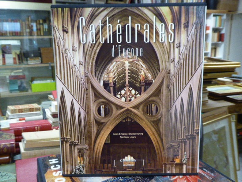
ERLANDE-BRANDENBURG Alain - LOURS Mathieu
CATHEDRALES D'EUROPE.
Citadelles & Mazenod Paris 2011 In-4 ( 345 X 295 mm ) de 4955 pages, pleine toile sous jaquette et étui illustrés en couleurs. Superbe et abondante iconographie en couleurs et en noir dans et hors-texte. Très bel exemplaire en superbe état.
书商的参考编号 : 238991
|
|
|
ERLANDE-BRANDENBURG Alain
DE PIERRE D'OR ET DE FEU. La création artistique au Moyen Age IVe-XIIIe siècle.
Paris Fayard 1999. In-8 broché 350pp. Petite pliure angulaire au bas du 1er plat de la couverture, quelques mots ou passages soulignés en début d'ouvrage, sinon exemplaire frais et complet. Envoi de l'Auteur sur le faux-titre. (BAL 24)
书商的参考编号 : GITj876
|
|
|
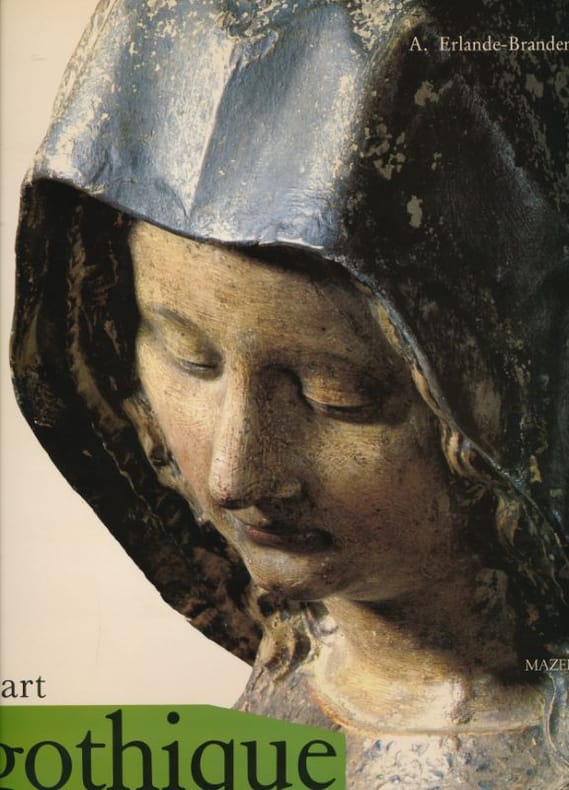
Erlande-Brandenburg, Alain
Gothic Art.
, H.N. Abrams, 1989 hardcover with dusjacket 630 pages, ENG. edition, 320 x 255 x 50 mm. ISBN 9780810906310.
书商的参考编号 : 63271
|
|
|
Erlande-Brandenburg, Alain (dir.)
Hugues Sambin Un créateur au XVIe siècle (v. 1520-1601)
Editions de la R.M.N., Les cahiers du musée national de la Renaissance, 1., Paris/Ecouen, 2001. In-8, broché sous couverture illustrée en couleurs, 126 pp. Préface, par Alain Erlande-Brandenburg - I. Hugues Sambin et son temps : Introduction. - La vie d'Hugues Sambin. - Hugues Sambin, créateur. - Hugues Sambin, l'art de la menuiserie et le décor d'architecture, par Henri-Stéphane Gulczynkski. - Les manières d'habiter. ...
书商的参考编号 : 6184
|
|
|
Erlande-Brandeburg Alain
L'architecture gothique
Jean paul Gisserot. Mai 2001. In-8. Broché. Très bon état, Couv. convenable, Dos satisfaisant, Intérieur frais. 30 pages augmentées de nombreuses photos en couleurs dans texte.. . . . Classification Dewey : 720-Architecture
书商的参考编号 : R260257745

|
|
|
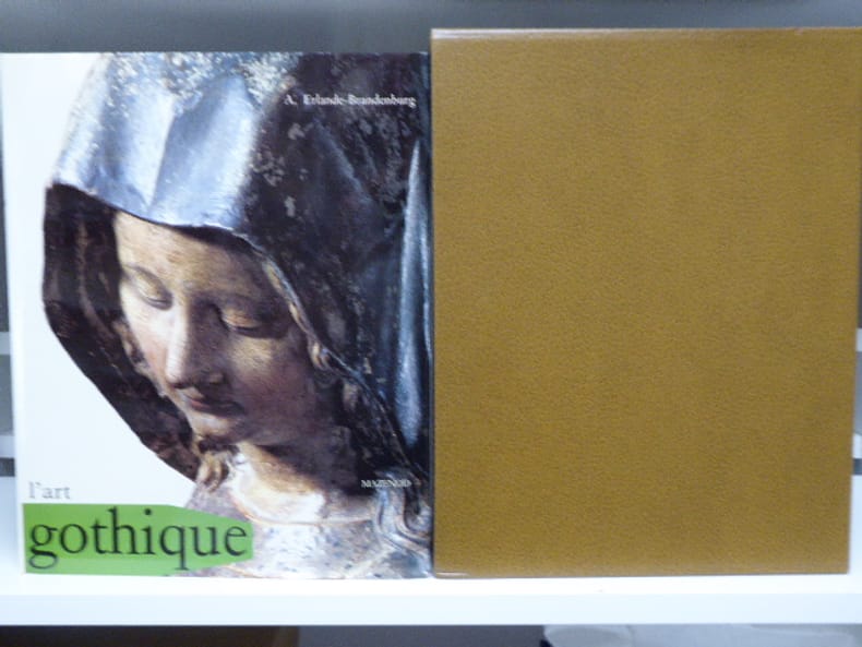
ERLANDE-BRANDEBURG A
L'Art Gothique
mazenod Mazenod 1983. Grand et fort In-4 relié toile éditeur beige sous jaquette illustrée et emboitage. 628 pages. Nombreuses photos. Avec index. Parfait état.
书商的参考编号 : 126304
|
|
|
ERLANDE-BRANDENBURG (Alain).
L'Art gothique.
S.l., Editions Citalles & Mazenod / Coll. ''L'Art et les grandes civilisations'', (1983). Un fort vol. au format in-4 (318 x 257 mm) de 627 pp. Pleine percaline d'édition, sous jaquette illustrée par la photographie.
书商的参考编号 : 19892

|
|
|
ERLANDE-BRANDEBURG A.
L'Art Gothique
Paris, éd. Mazenod, coll. "L'Art et les grandes civilisations", 1983 - fort in-folio, reliure éditeur pleine toile, couv. et jaquette illustrées, 628 pages, très nbses illustrations couleurs (souvent pleine page) et N&B -TBE
书商的参考编号 : 29443
|
|
|
ERLANDE-BRANDEBURG Alain
L'ART GOTHIQUE.
Citadelles & Mazenod Paris 1983 Fort in-4 carré ( 320 X 255 mm ) de 628 pages, pleine toile sous jaquette illustrée en couleurs et étui maroquiné taupe. Superbe et abondante iconographie en couleurs et en noir dans et hors-texte. Très bel exemplaire en parfait état.
书商的参考编号 : 558749
|
|
|
ERLANDE-BRANDENBURG ALAIN
L'EGLISE ABBATIALE DE SAINT-DENIS, TOME II, LES TOMBEAUX ROYAUX
SCOP-SADAG. 1979. In-8. Broché. Bon état, Couv. convenable, Dos satisfaisant, Intérieur frais. Env. 50 pages. Illustré de nombreuses photos en noir et blanc (héliogravées) et en couleur, dans et hors texte. Annotations en page de titre. Photo en noir et blanc scotchée sur le 2e plat.. . . . Classification Dewey : 720-Architecture
书商的参考编号 : RO40123090
|
|
|
Erlande-Brandeburg Alain
La cathédrale
Le grand livre du mois. 1989. In-8. Broché. Très bon état, Couv. convenable, Dos satisfaisant, Intérieur frais. 418 pages augmentées de quelques schémas et photos en noir et blanc dans texte.. . . . Classification Dewey : 720-Architecture
书商的参考编号 : R260251303

|
|
|
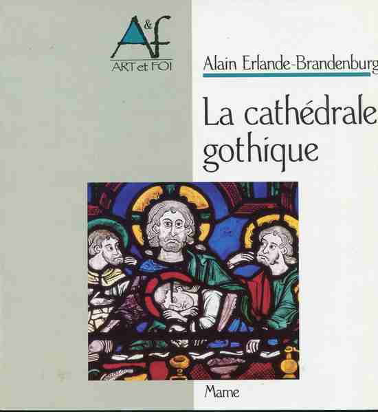
ERLANDE-BRANDENBURG Alain
La cathédrale gothique
,Paris, Mame 1990, 79 pp., 1 vol. in 8 carré br. couverture illustrée, illustrations in et hors-texte en noir et en couleurs.
书商的参考编号 : 17716
|
|
|
ERLANDE-BRANDENBURG Alain
La cathédrale.
Paris, Fayard, 1989. 16 x 24, 418 pp., nombreuses figures, cartonnage souple d'édition, bon état.
书商的参考编号 : 33821
|
|
|
ERLANDE-BRANDENBURG Alain
La Cathédrale.
Paris, Fayard, 1989. 16 x 24, 418 pp., 160 figures, reliure souple d'édition, très bon état (1 cachet et 1 signature d'ex-particulier sur la page de faux-titre).
书商的参考编号 : 84762
|
|
|
ERLANDE-BRANDENBURG Alain
La cathédrale gothique. Collection : Art et Foi.
Paris, Mame, 1990. 22 x 23, 79 pp., quelques illustrations, en couleurs et en N/B, quelques cartes et plans, broché, bon état (1 cachet et 1 signature de l'ex-particulier).
书商的参考编号 : 85945
|
|
|
Erlande-Brandenburg Alain
La Cathédrale
Fayard 1989 In-8 cartonné 24 cm sur 15,5. 418 pages. Bon état d’occasion.
书商的参考编号 : 96531
|
|
 ?????????
 ?????PDF???
 RSS feed


