|
Chatelain Henri Abraham.
Atlas historique ou Nouvelle introduction a l'histoire a la chronologie & a la geographie ancienne & moderne : representee dans de nouvelles cartes ou l'on remarque l'etablissement des etats & empires du monde leur duree leur chute & leurs differens gouvernemens : la chronologie des consuls romains des Papes de empereurs des rois & des princes &c. qui ont ete depuis le commencement du monde jusqu'a present : et la genealogie des maisons souveraines de l'Europe. / par Mr. C. ; avec des dissertations sur l'histoire de chaque etat par Mr. Gueudeville. 6. Volume 6. 1739
2020. Paperback. New. Lang: - fre Vol: - Volume 6. Pages 328. Reprinted in 2020 with the help of original edition published long back 1739. This book is Printed in black & white sewing binding for longer life with Matt laminated multi-Colour Soft Cover HARDCOVER EDITION IS ALSO AVAILABLE Printed on high quality Paper re-sized as per Current standards professionally processed without changing its contents. As these are old books we processed each page manually and make them readable but in some cases some pages which are blur or missing or black spots. We expect that you will understand our compulsion in these books. We found this book important for the readers who want to know more about our old treasure so we brought it back to the shelves. Any type of Customisation is possible with extra charges. Hope you will like it and give your comments and suggestions. Volume 6. paperback
Bookseller reference : PB1111009757951
|
|
|
Chatelain Henri Abraham.
Atlas historique ou Nouvelle introduction a l'histoire a la chronologie & a la geographie ancienne & moderne : representee dans de nouvelles cartes ou l'on remarque l'etablissement des etats & empires du monde leur duree leur chute & leurs differens gouvernemens : la chronologie des consuls romains des Papes de empereurs des rois & des princes &c. qui ont ete depuis le commencement du monde jusqu'a present : et la genealogie des maisons souveraines de l'Europe. / par Mr. C. ; avec des dissertations sur l'histoire de chaque etat par Mr. Gueudeville. 6. Volume 6. 1739 Hardcover
2020. Hardcover. New. Lang: - fre Vol: - Volume 6. Pages 328. Reprinted in 2020 with the help of original edition published long back 1739. This book is printed in black & white Hardcover sewing binding for longer life with Matt laminated multi-Colour Dust Cover Printed on high quality Paper re-sized as per Current standards professionally processed without changing its contents. As these are old books we processed each page manually and make them readable but in some cases some pages which are blur or missing or black spots. We expect that you will understand our compulsion in these books. We found this book important for the readers who want to know more about our old treasure so we brought it back to the shelves. Any type of Customisation is possible with extra charges. Hope you will like it and give your comments and suggestions. Volume 6. hardcover
Bookseller reference : 1111009757951
|
|
|
CHATELAIN Henri Abraham.
Cairo Egypt. Vûë de la ville du grand Caire et de ses environs.
Atlas Historique. 1740. Copper engraving. Hand coloured. Fine condition Size: 43.5 x 37.5 cm. 17 x 15 inches Chateleain's Atlas Historique was a major seven volume atlas and encyclopaedia ornately decorated and with text by Nicholas Geudeville Atlas Historique. unknown
Bookseller reference : 58011
|
|
|
CHATELAIN Henri Abraham.
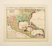
Carte Contenant le Royaume du Mexique et la Floride
Amsterdam 1719. Size: 515 x 400 mm. Mounted size: 700 x 600 mm. Copper engraving. Later colour Overall good condition some browning down centrefold from hingeguard. Châtelain's superb map of North America and the West Indies from Newfoundland and the Great Lakes to northern South America based on the earlier Delisle map of the region. This map highlighted significant discoveries and recently acquired knowledge along the gulf coast not long after the area was opened up to non Spanish flag carrying ships. Inset with remarks on Mexico and Florida. From the popular 7-volume Atlas Historique. Amsterdam unknown
Bookseller reference : 55022
|
|
|
Chatelain Henri Abraham
Carte de L'Asie selon les… Remarques Historiques…
copper engraving.Map showing in planispheric projection an area stretching from East Africa to Japan and Papua surrounded by extensive engraved text on three sides from the 7-volume 'Atlas Historique' Tom: V. Nro 3. Pag:16. Condition: centrefold as issued very good condition. published in Amsterdam.
Bookseller reference : 62649

|
|
|
Chatelain Henri Abraham
Carte du Gouvernement de l'Amerique. 1. Conseil de L'Amerique Septentrionalle. 2. Conseil des Indes de Madrid. 3. Conseil de Terre Ferme. 4. Conseil de L'Amerique Meridionalle. 5. Carte de L'Amerique
copper engraving wide margin with vertical folds as issued verso: blank. Fascinating sheet from the 'Atlas historique….' plate no. 39. Sheet shows a map of North and South America amidst a text overview of the governance structure of the Spanish overseas territories and vignettes of meetings of their governing bodies. published in Amsterdam.
Bookseller reference : 61975

|
|
|
CHATELAIN Henri Abraham.
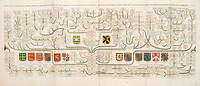
Carte généalogique de la maison de Plantagenette et des ducs Normandie
Atlas Historique. Tome 2 N°47. c.1720. Copper engraving. Hand coloured. Very good condition. 2sheets joined. Size: 99 x 38 cm. An attractive and fascinating genealogical chart of mediaeval English royal families seven coats of arms of Edward the Confessor Edward III the Plantagenets the Duke of Normandy and others. Atlas Historique. Tome 2 N°47. unknown
Bookseller reference : 60647
|
|
|
CHATELAIN Henri Abraham.
Carte généalogique de la maison de Stuart dans la Quelle Lon Fait Observer Son Origine.
Atlas Historique. Tome 2 N°48. c.1720. Copper engraving. Hand coloured. Very good condition. Size: 37.5 x 46.5 cm. An attractive plate with the genealogy of the House of Stuart decorated with four coats-of-arms pertaining to military alliances. Atlas Historique. Tome 2 N°48. unknown
Bookseller reference : 60655

|
|
|
CHATELAIN Henri Abraham.
Carte généalogique de la maison de Plantagenette et des ducs Normandie
Atlas Historique. Tome 2 N°47. c.1720. Copper engraving. Hand coloured. Very good condition. Size: 99 x 38 cm. An attractive and fascinating genealogical chart of mediaeval English royal families seven coats of arms of Edward the Confessor Edward III the Plantagenets the Duke of Normandy and others. Atlas Historique. Tome 2 N°47. unknown
Bookseller reference : 58381

|
|
|
CHATELAIN Henri Abraham 1684 1743
Carte qui contient une description des iles & terres que les Anglois possedent dans l'Amerique septentrionale et en particulier de la Jamaique des Iles Barbades de la Nouvelle Angleterre Des Barmudesde la Caroline de la Pensilvanie et du New-Foundland avec un Etat de Chaque Pais.
Amsterdam 1719. Engraving with 8 maps on one sheet. An attractive combination of text and illustration and an important record of the French perception of British holdings in the Americas. This charming plate is typical of the work that makes Chatelain's atlas one of the great works of its era. The engraved sheet here combines informative text mostly about Jamaica with small-scale but accurate maps of eight different locations: Barbadoes; New England New York; Bermuda; Jamaica; the Caribbean; the Carolinas with Virginia and Maryland; Maryland Pennsylvania and New England; south east Canada with a part of New England. This charming grouping is characteristic of the marvelous engraving work which distinguishes the Atlas Historique with maps by Chatelain and text by Nicholas Gueudeville. JCB 'Archive of Early American Images' record number 12376-2; cf. van Waning "Chatelain's Atlas Historique" in Journal of the International Map Collectors' Society Spring 2010. unknown
Bookseller reference : 25722

|
|
|
CHATELAIN Henry Abraham 1684 1743 & LAHONTAN Louis Armand de Lom d'Arce La Hontan Baron de 1666 1715 & HENNEPIN Father R
Carte qui contient la maniere Niagara
The Hague 1718. No binding. Very Good. Coloured. A good and dark impression. Decorative colours. VG condition. Size: 14.4 x 16.8 inches. 36.7 x 42.7 cm. A series of 12 engravings together with descriptive text derived from the works of Lahontan and Hennepin. They illustrate the methods of the Indians hunting buffalo and similar animals the Pipe of Peace the dances in honour of important meetings or occasions and the emblems of the various tribes I.e. Outagamis apelles Renards: Pouteouatamis appelles Puants Outchipoues appeles Sauteurs Nadovessis appeles Scioux Outaguas V. Nations Huron Ilinois Oumamis. There is also a large inset of the Niagara Falls and a Buffalo. A fascinating item. The Hague unknown
Bookseller reference : 1608

|
|
|
Chatelain Henri Abraham
Carte tres curieuse de la mer du sud contenant des remarques Nouvelles et tres utiles non Seulement sur les ports et iles de cette mer. 1st and 2nd Sheet A Very Special Map of the Southern Sea Containing New and Very Useful Descriptions not Only of its Ports and Islands.
original outline-colour copper engravings. EXTREMELY RARE stunning World map in 2 sheets from the extensive multi-volume 'Atlas Historique' vol. 6 no. 30 p. 117; published by Chatelain Amsterdam. One of the most imformative decorative and impressive maps centered on the Pacific available. Printed on four large sheets joined upper two and separately the two lower ones it is of wall-chart proportions and a veritable pictorial encyclopaedia of the western hemisphere including the Philippines; many famous voyagers' tracks/routes are indicated. Condition: 1st sheet - folds as issued small tear on lower centrefold; 2nd sheet - folds as issued small water stain on lower right margin; due to imperfect printing the neatlines are not perfectly parallel neither horizontally nor vertically. Otherwise Excellent. References: Not in Quirino; Phillips 579; Goss Kartenkunst Taf. 7.5; Ders. North America map 52; Portinaro/Knirsch p. 216/7 all 3 with crude but col. image.; Tooley California No. 80; Tooley Early Maps of Australia No. 66; Wagner NW Coast America Nr. 511; Lowery No. 291 only Northern part; Lietz Insulae India Orientalis p. 132<br /><br /><br /><br /><br /> Chatelain, Amsterdam.
Bookseller reference : 62639/62640

|
|
|
CHATELAIN Henri Abraham
Carte très Curieuse de la Mer du Sud contenant des remarques nouvelles et très utiles non seulement sur les Ports et Iles de cette mer. les Noms et la Route des Voyageurs.
Paris: l'Honore & Chatelain 1719. In fine and crisp condition. Engraved map with fine hand colouring printed in four sheets joined 860 x 1440 mm.; mounted and framed. A splendid example of Henri Châtelain's rare and magnificent wall chart of the Pacific and its surrounds. Described by Schwartz as "one of the most elaborately engraved maps" and Goss as "one of the most decorative and impressive maps of the Americas and .a veritable pictorial encyclopedia of the western hemisphere" this is undoubtedly one of the most richly decorated world maps ever produced. Australia is charted according to the discoveries of Tasman from seventy-five years earlier and Hartog before him: "Nouvelle Hollande découverte l'an 1644" and the new place name "Golfo de Carpentarie" is recorded. The north of the continent is shown strangely flattened and the south coast of Tasmania "Terre d'Antoine Diemens" is placed at a great distance from the rest of the continent. A strangely shaped New Guinea neighbours the Solomon Islands which reference the discoveries of Mendana and Quiros; the mysterious "Terre De Quir"� -- the Quiros discoveries still having currency after a century has passed -- here seems to credit Pedro Fernendez de Quir with the discovery of eastern Australia. Châtelain's map is centred on the Americas extending west to include all of the Pacific as far as China and Australia and east to include much of Europe and the western half of Africa. Its aim was to educate the reader in matters of geography cosmography topography heraldry and ethnography and this information-rich map is a visual celebration of the age of discovery. In the centre top of the chart are portrait medallions of the major explorers including Magellan Columbus Vespucci Drake Dampier Jacques L'Hermite and Schouten. There are brief descriptions of their achievements and the tracks of their great voyages of discovery are marked. There are five voyages marked across the Pacific including that of Magellan in 1520 Le Maire and Schouten in 1616 and L'Hermite in 1625. Clustering around the margins of the chart are sumptuously engraved and richly coloured vignettes depicting indigenous peoples and exotic flora and fauna of the New World as well as famous historic events. Some of the images such as the scene of beavers building dams and the view of the codfish factory are derived from Herman Moll. There are several short paragraphs of text on the map giving information about the features government and people of different countries the tides and winds. Significantly this is one of the first maps to begin to dispel the myth of California as an island. Although it is tentatively drawn as such a notation states that "moderns" believe it to be part of the mainland. The Carte très Curieuse was originally issued in the sixth volume of Châtelain's encyclopedic Atlas Historique ou Nouvelle Introduction à l'histoire à la Chronologie et à la Géographe Ancienne et Moderne which was published in seven folio volumes between 1705 and 1720. This rare and important map the outstanding highlight of the atlas was also separately issued. Very few maps of this scale have survived fewer still in such excellent condition. l'Honore & Chatelain unknown
Bookseller reference : 4504770

|
|
|
Chatelain Henry Abraham
Coutumes Moeurs & Habillemens des Peuples Qui Habitent aux Environs de Cap de Bonne Esperance avec Une Description des Animaux et Reptiles Qui se Trouvent Dans ce Paris
1719. Very good. Small repaired tear to the top margin and 2cm split to the bottom centre fold. Depicting the customs and habits of the people who live around the Cape of Good Hope. With a map of Southern Africa with details such as the Namaquas in the North to Cap de Arguilles at the southernmost tip. unknown
Bookseller reference : 300479

|
|
|
Chatelain Henri Abraham
Description des Castors & Le Leur Industrie Des Canots Habitations Habilemens Maniere De Vivre Des Sauvages Du Canada
Amsterdan 1719. Map/Print. Fine. No Binding. c. 1719. Engraved leaf of text with illustrations 38 x 52 cm. from Chatelain's Atlas Historique ou Nouvelle Introduction a l'Histoire a la Chronoligie & a la Geographie Ancienne & Modern.1705-1720 Vol. VI. unknown
Bookseller reference : 025037
|
|
|
CHATELAIN Henri Abraham.
En nouvelle carte des états du grand duc de Muscovie Europe.
1710. Copper engraving. Later colour. Good margins closed tear at right margin expertly repaired. Very good condition. Size: 45 x 35 cm. 17½ x 14 inches A beautiful map of the northern part of European Russia from 58 degrees Saint Petersburg northwards to the arctic coast. The map shows the different provinces rivers forests and towns. unknown
Bookseller reference : 53643

|
|
|
CHATELAIN Henri Abraham.
Généalogie des rois d'Angleterre.
c1720. Copper engraving. Later colouring. Very good condition. Waterstain on lower and left hand edge not affectingand well clear of the map Size: 44 x 37.5 cm. 17½ x 15 inches. Interesting plate with two maps side by side - 1. Scotland 2. England and Wales with a list of the principal battles in England two coats of arms of England and Scotland. The chart is the left half of a larger chart but with the maps of England and Scotland at the centre makes an attractive chart by itself. unknown
Bookseller reference : 53003

|
|
|
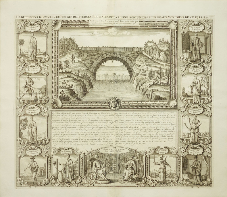
CHATELAIN Henri Abraham
Habillemens d'Hommes & de Femmes de Diverses Provinces de la Chine avec un des plus beaux Monumens de ce Pais-La
Amsterdam: Henri Abraham Chatelain 1719. unbound. very good. View. Engraving with hand coloring. Image measures 14 3/4" x 17". Beautiful double page landscape view of a bridge bordered by eleven examples of Chinese dress from different provinces. The ethnographic studies show various types of people including physicians religious figures royalty soliders farmers and commoners from Hunan Sichuan Shanxi Huqueng Chekiang Tartary Quansi Quicheu Fokien and Nankin regions. French text describes the Xensi province bridge. A few minor creases. Full original margins. Henri Abraham Chatelain unknown
Bookseller reference : 225955

|
|
|
Chatelain Henri Abraham. aut FrPBN
L'EIducation mise aI€ la porteIe de tout le monde par Henri-Abraham Chatelain 1781
2020. Paperback. New. Lang: - fre Pages 170. Reprinted in 2020 with the help of original edition published long back 1781. This book is Printed in black & white sewing binding for longer life with Matt laminated multi-Colour Soft Cover HARDCOVER EDITION IS ALSO AVAILABLE Printed on high quality Paper re-sized as per Current standards professionally processed without changing its contents. As these are old books we processed each page manually and make them readable but in some cases some pages which are blur or missing or black spots. If it is multi volume set then it is only single volume if you wish to order a specific or all the volumes you may contact us. We expect that you will understand our compulsion in these books. We found this book important for the readers who want to know more about our old treasure so we brought it back to the shelves. Any type of Customisation is possible with extra charges. Hope you will like it and give your comments and suggestions. paperback
Bookseller reference : PB1111006276359
|
|
|
Chatelain Henri Abraham. aut FrPBN
L'EIÂducation mise aI€ la porteIÂe de tout le monde par Henri-Abraham Chatelain 1781 Leather Bound
2019. Leather Bound. New. Leather Binding on Spine and Corners with Golden Leaf Printing on round Spine. Reprinted in 2019 with the help of original edition published long back 1781. This book is printed in black & white sewing binding for longer life Printed on high quality Paper re-sized as per Current standards professionally processed without changing its contents. As these are old books we processed each page manually and make them readable but in some cases some pages which are blur or missing or black spots. If it is multi volume set then it is only single volume if you wish to order a specific or all the volumes you may contact us. We expect that you will understand our compulsion in these books. We found this book important for the readers who want to know more about our old treasure so we brought it back to the shelves. Hope you will like it and give your comments and suggestions. Lang: - fre Pages 170. EXTRA 10 DAYS APART FROM THE NORMAL SHIPPING PERIOD WILL BE REQUIRED FOR LEATHER BOUND BOOKS. FOLIO EDITION IS ALSO AVAILABLE. hardcover
Bookseller reference : LB1111006276359
|
|
|
Chatelain Henri Abraham. aut FrPBN
L'EIÂducation mise aI€ la porteIÂe de tout le monde par Henri-Abraham Chatelain 1781 Hardcover
2020. Hardcover. New. Lang: - fre Pages 170. Reprinted in 2020 with the help of original edition published long back 1781. This book is Printed in black & white Hardcover sewing binding for longer life with Matt laminated multi-Colour Dust Cover Printed on high quality Paper re-sized as per Current standards professionally processed without changing its contents. As these are old books we processed each page manually and make them readable but in some cases some pages which are blur or missing or black spots. If it is multi volume set then it is only single volume if you wish to order a specific or all the volumes you may contact us. We expect that you will understand our compulsion in these books. We found this book important for the readers who want to know more about our old treasure so we brought it back to the shelves. Any type of Customisation is possible with extra charges. Hope you will like it and give your comments and suggestions. hardcover
Bookseller reference : 1111006276359
|
|
|
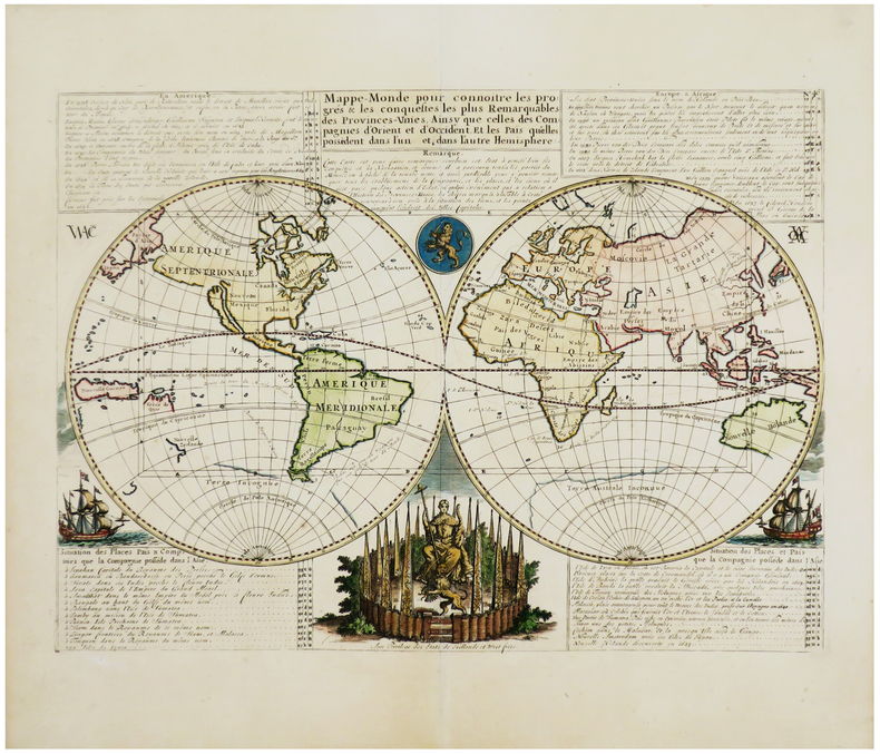
Chatelain Henry Abraham
Mappe-Monde pour Connoitre les Progres & les Conquestes les Plus Remarquables des Provinces-Unies ainsy que celles des Compagnies d'Orient et d'Occident et les Pais quelles Possedent dans l'un et dans l'autre Hemisphere
Amsterdam 1705. Unusual double-hemisphere map of the world illustrating the success of the Dutch East and West India Companies throughout the world. With text above and below sailing ships lions and the figure of Europa seated inside a native fort. Showing California as an island incomplete Australia and New Zealand and the west coast of America extending toward Asia. From Chatelain's 'Atlas Historique'. Uncolored . Image size: 18 x 13". References: MCC 2 Tooley - Antarctica #54. Very good. <br/><br/> unknown
Bookseller reference : 16453

|
|
|
CHATELAIN Henri Abraham.
Nouvelle Carte Pour Introduire A La Geographie et a La Genealogie des Rois Angleterre et D'Ecosse
Atlas Historique. Tome 2 N° 46. c.1720. Copper engraving. Hand coloured. Very good condition. 2sheets joined. Size: 38 x 92 cm. An attractive and fascinating genealogical chart of mediaeval English and Scottish royal families. Atlas Historique. Tome 2 N° 46. unknown
Bookseller reference : 60650
|
|
|
Chatelain Henri Abraham
Nouvelle Carte Du Gouvernement Civil D'Angleterre Et de Celuy De La Ville De Londres
Amsterdam: c1719. An engraved map on laid paper printing two hand-coloured maps and two hand-coloured allegorical scenes. Text in French. Image size is 47cm x 35 cm. Verso blank. Pin holes at corners slight splitting at central fold a clean and attractive copy nicely coloured. Issued in Chatelain's 7-Volume Atlas Historique marked at upper plate: Tome 2. No. 53. The maps are a plan of London and a map of England with an alphanumeric key beneath. <br/><br/> Amsterdam: c,1719. unknown
Bookseller reference : 56004

|
|
|
CHATELAIN Henri Abraham. 1684 1743
Nouvelle Carte De L'Amerique Septentrionale Dressee Sur Les Plus Nouvelles Observations.
Amsterdam 1710. Copper-engraved map period hand-colouring in outline. Tables upper left and along the right side. Attractive map of North America based upon De L'Isle's highly influential map of North America published in 1700. By combining a wealth of information and geographical observation with delicate engraving and an uncomplicated composition this elegant map is a superb example from the golden age of French mapmaking and was published in Chatelain's Atlas Historique an important encyclopaedic historical atlas. California is shown as a peninsula with a number of villages and mountains; the Mississippi River extends far north of its true source. The table along the right side details the various native tribes from each region with lettered references for locating on the map. Lowery 263; Phillips 579. unknown
Bookseller reference : 25803

|
|
|
CHATELAIN Henri Abraham.
Particularitez curieuses de l'Ile de St. Christophle et de la Province de Bemarin dans les Antilles.
Amsterdam. c1720. Copper engraving. Uncoloured. Fine condition Size: 48 x 37 cm. This fascinating engraving has three views of St. Kitt's above texts in French about St Kitts and the province of Bemarin at centre and below there are three prints of fishes birds and insects of the island. Title on top edge. Chatelain's Atlas Historique in seven volumes half atlas and half encyclopaedia was a massive and important work of its time. From the Atlas Historique. Amsterdam. unknown
Bookseller reference : 53014

|
|
|
Chatelain Henri Abraham:
Title-page Atlas Historique
Amsterdam c. 1705. Copper engraved title-page 40 x 24.5 cms black and white as issued blank verso. Engraved for the first volume of Chatelain�s historical atlas. The classical muses represent Chronology History Navigation and Geography. Atlas braces himself against a crumbling pyramid supporting the heavens while the title of the atlas is suspended on a banner borne by the winged angel of fame. Shirley Courtiers & Cannibals 75. Map unknown
Bookseller reference : 5584

|
|
|
CHATELAIN Henri Abraham
Habillemens d'Hommes & de Femmes de Diverses Provinces de la Chine avec un des plus beaux Monumens de ce Pais-La
Amsterdam: Henri Abraham Chatelain 1719. unbound. very good. View. Engraving with hand coloring. Image measures 14 3/4" x 17".<br/><br/> Beautiful double page landscape view of a bridge bordered by eleven examples of Chinese dress from different provinces. The ethnographic studies show various types of people including physicians religious figures royalty soliders farmers and commoners from Hunan Sichuan Shanxi Huqueng Chekiang Tartary Quansi Quicheu Fokien and Nankin regions. French text describes the Xensi province bridge. A few minor creases. Full original margins.<br/><br/> Henri Abraham Chatelain unknown books
Bookseller reference : 225955
|
|
|
CHATELAIN Henri Abraham 1684 1743
Carte qui contient une description des iles & terres que les Anglois possedent dans l'Amerique septentrionale et en particulier de la Jamaique des Iles Barbades de la Nouvelle Angleterre Des Barmudes de la Caroline de la Pensilvanie et du New-Foundland avec un Etat de Chaque Pais.
Amsterdam 1719. Engraving with 8 maps on one sheet. An attractive combination of text and illustration and an important record of the French perception of British holdings in the Americas. This charming plate is typical of the work that makes Chatelain's atlas one of the great works of its era.<br/> <br/>The engraved sheet here combines informative text mostly about Jamaica with small-scale but accurate maps of eight different locations: Barbadoes; New England New York; Bermuda; Jamaica; the Caribbean; the Carolinas with Virginia and Maryland; Maryland Pennsylvania and New England; south east Canada with a part of New England. This charming grouping is characteristic of the marvelous engraving work which distinguishes the Atlas Historique with maps by Chatelain and text by Nicholas Gueudeville.<br/> <br/>JCB 'Archive of Early American Images' record number 12376-2; cf. van Waning "Chatelain's Atlas Historique" in Journal of the International Map Collectors' Society Spring 2010. unknown books
Bookseller reference : 25722
|
|
|
CHATELAIN Henri Abraham 1684 1743
Nouvelle Carte De L'Amerique Septentrionale Dressee Sur Les Plus Nouvelles Observations.
Amsterdam 1710. Copper-engraved map period hand-colouring in outline. Tables upper left and along the right side. Attractive map of North America based upon De L'Isle's highly influential map of North America published in 1700.<br/> <br/>By combining a wealth of information and geographical observation with delicate engraving and an uncomplicated composition this elegant map is a superb example from the golden age of French mapmaking and was published in Chatelain's Atlas Historique an important encyclopaedic historical atlas. California is shown as a peninsula with a number of villages and mountains; the Mississippi River extends far north of its true source. The table along the right side details the various native tribes from each region with lettered references for locating on the map.<br/> <br/>Lowery 263; Phillips 579. unknown books
Bookseller reference : 25803
|
|
|
CHATELAIN (Henry Abraham).
[ALGERIE] Vue de Tunis d'Alger & de Gigeri avec quelques particularitez curieuses touchant les moeurs de leurs habitans.
[Amsterdam, circa 1720]. 377 x 434 mm.
Bookseller reference : LBW-1077

|
|
|
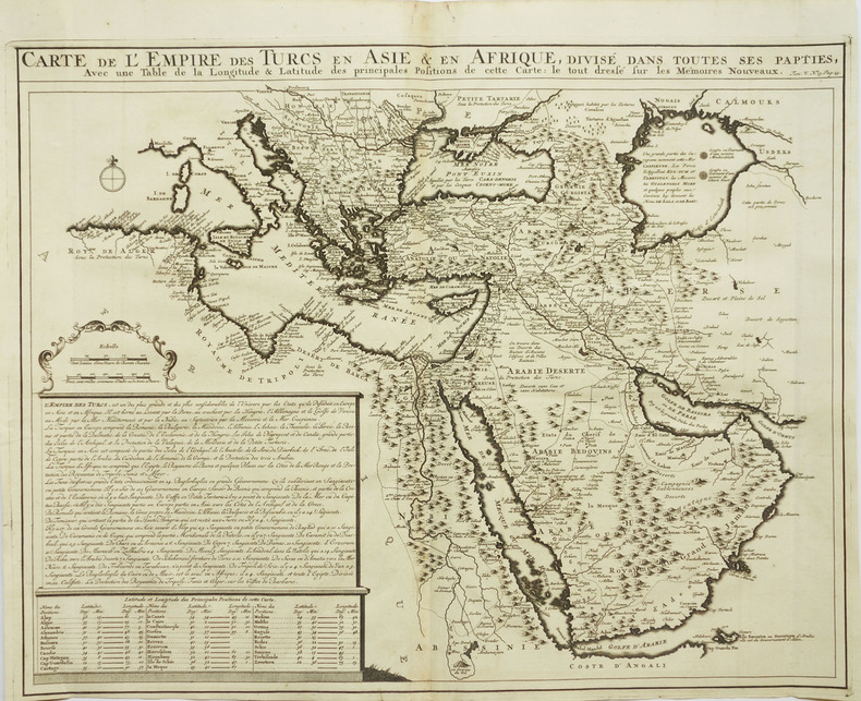
CHATELAIN (Henry Abraham).
[ARABIE] Carte de l'empire des Turcs en Asie & en Afrique, divisé dans toutes ses pap[r]ties, avec une table de la longitude & latitude des principales positions de cette carte.
Amsterdam, circa 1720. 400 x 512 mm.
Bookseller reference : LBW-2043
|
|
|
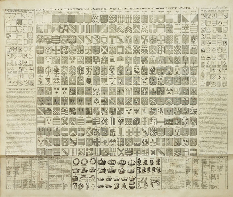
CHATELAIN (Henry Abraham).
[BLASONS] Carte du blason ou la sience de la noblesse avec des instructions pour conduire à cette connoissance.
Amsterdam, circa 1720. 490 x 598 mm.
Bookseller reference : LBW-2047
|
|
|
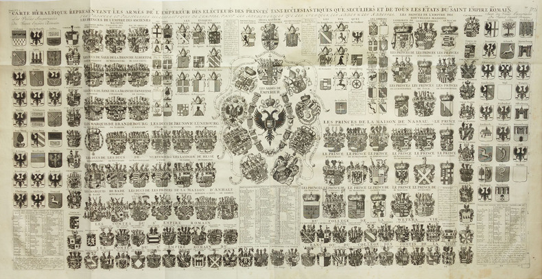
CHATELAIN (Henry Abraham).
[BLASONS] Carte héraldique représentant les armes de l'empereur des électeurs des princes tant ecclésiastiques que séculiers et de tous les états du Saint Empire romain.
Amsterdam, circa 1720. En deux feuilles jointes de 490 x 985 mm.
Bookseller reference : LBW-2017
|
|
|
CHATELAIN (Henry Abraham).
[CONGO] Vue & description de la ville de Lovango dans le royaume de Congo.
[Amsterda, circa 1720]. 376 x 431 mm.
Bookseller reference : LBW-1074

|
|
|
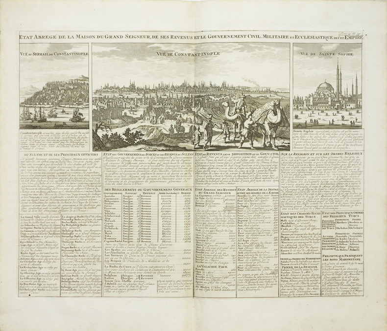
CHATELAIN (Henry Abraham).
[CONSTANTINOPLE] Etat abrégé de la Maison du Grand Seigneur, de ses revenus et le gouvernement civil, militaire et ecclésiastique de cet empire.
Amsterdam, circa 1720. 346 x 453 mm.
Bookseller reference : LBW-2030
|
|
|
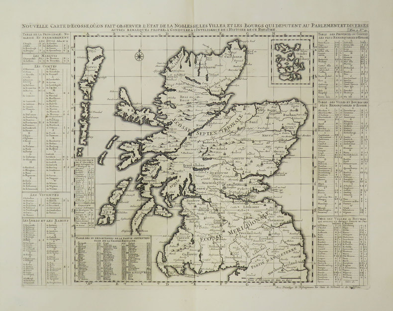
CHATELAIN (Henry Abraham).
[ECOSSE] Nouvelle carte d'Ecosse, où l'on fait observer l'état de la noblesse, les villes, et les bourgs qui députent au Parlement.
[Amsterdam, 1708]. 354 x 462 mm.
Bookseller reference : LBW-3521
|
|
|
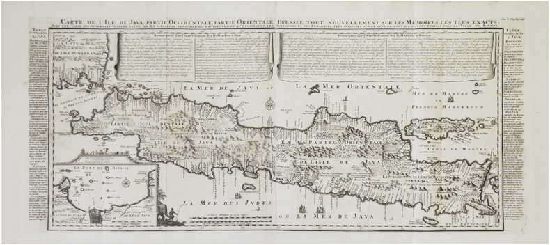
CHATELAIN (Henry Abraham).
[JAVA] Carte de l'île de Java : partie occidentale, partie orientale, dressée tout nouvellement sur les mémoires les plus exacts ; avec une table des principales villes de cette île, la situation des comptoirs & autres places qu'y possèdent les Hollandois, et des remarques très curieuses sur la manière dont ils se sont établis dans la ville de Batavia.
[Amsterdam, circa 1720]. En deux feuilles jointes de 375 x 870 mm.
Bookseller reference : LBW-2041
|
|
|
CHATELAIN (Henry Abraham).
[LE CAIRE] Vûë de la ville du grand Caire, et de ses environs.
Amsterdam, circa 1720. 365 x 430 mm.
Bookseller reference : LBW-2029

|
|
|
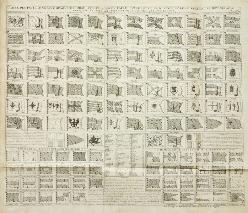
CHATELAIN (Henry Abraham).
[PAVILLONS] Carte des pavillons accompagnée d'observations pour en faire comprendre le blazon et les différentes devises aussy bien que d'une table alphabétique pour les trouver facilement.
Amsterdam, circa 1720. 490 x 585 mm.
Bookseller reference : LBW-2016
|
|
|
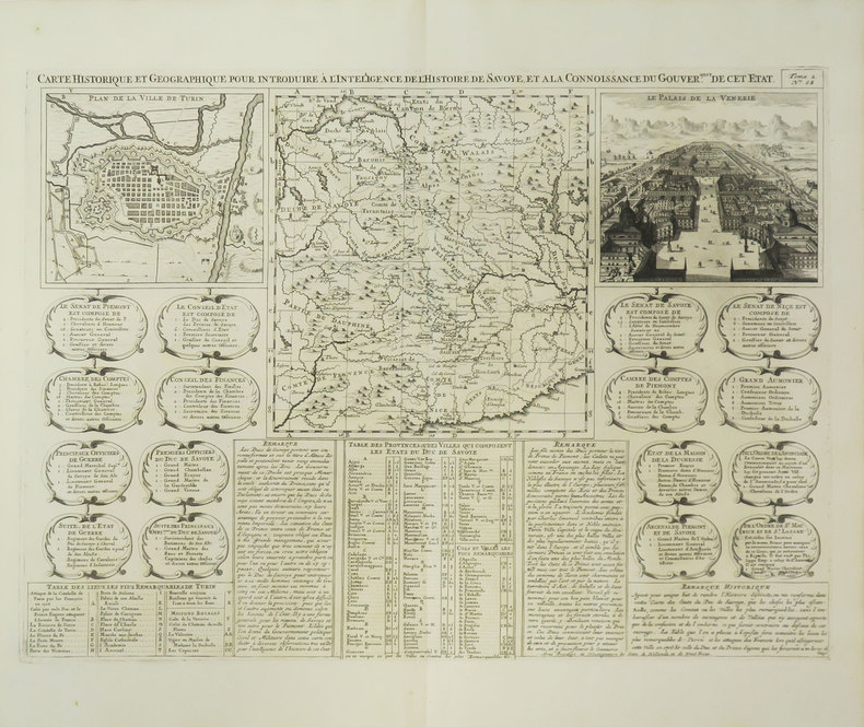
CHATELAIN (Henry Abraham).
[TURIN] Carte historique et géographique pour introduire à l'intelligence de l'histoire de Savoye, et à la connoissance du gouver.ment de cet état.
[Amsterdam, 1708]. 352 x 480 mm.
Bookseller reference : LBW-3528
|
|
|
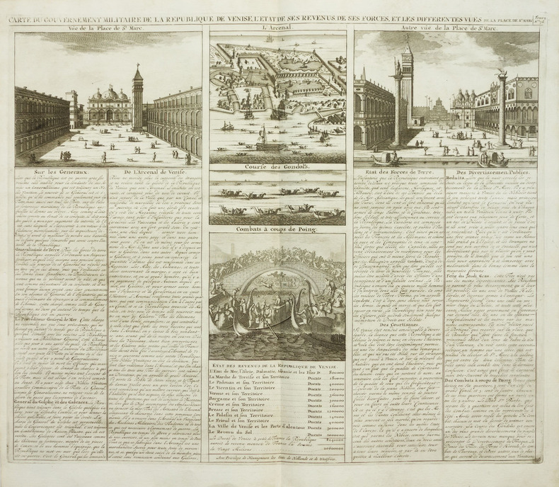
CHATELAIN (Henry Abraham).
[VENISE] Carte du gouvernement militaire de la République de Venise, l'état de ses revenus, de ses forces, et les différentes vues de la place St. Marc.
Amsterdam, vers 1705. 390 x 460 mm.
Bookseller reference : LBW-2033
|
|
|
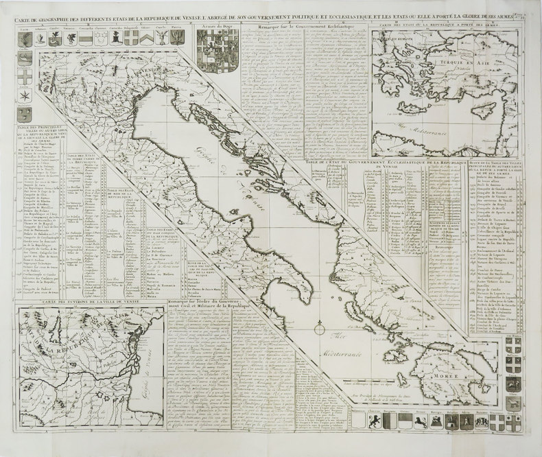
CHATELAIN (Henry Abraham).
Carte de géographie des différents états de la République de Venise.
[Amsterdam, 1708]. 497 x 612 mm.
Bookseller reference : LBW-3452
|
|
|
CHATELAIN (Henry Abraham).
Carte des trois ordres qui composent l'état de la République de Pologne, sçavoir le roi, le sénat et la noblesse.
Amsterdam, circa 1720. 345 x 447 mm.
Bookseller reference : LBW-2012

|
|
|
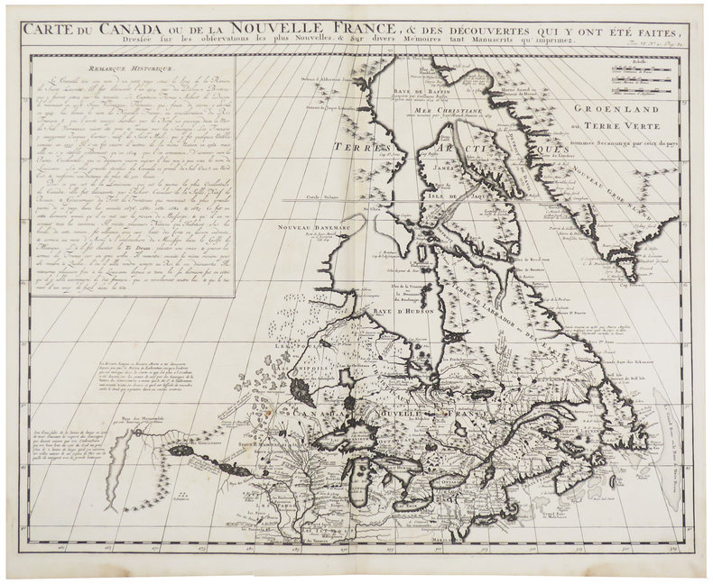
CHATELAIN (Henry Abraham).
Carte du Canada ou de la Nouvelle France, & des découvertes qui y ont été faites.
[Amsterdam, circa 1720]. 405 x 515 mm.
Bookseller reference : LBW-5477
|
|
|
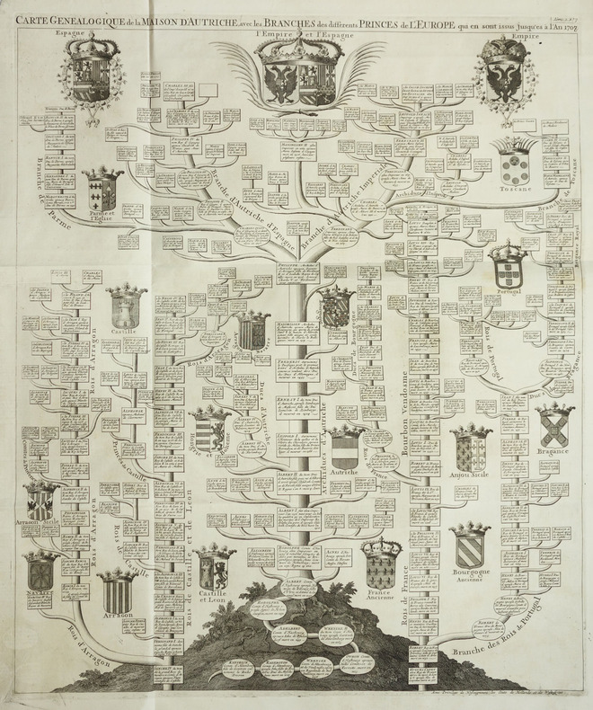
CHATELAIN (Henry Abraham).
Carte généalogique de la Maison d'Autriche, avec les branches des différents princes de l'Europe qui en sont issus jusqu'es à l'an 1708.
Amsterdam, circa 1720. 615 x 508 mm.
Bookseller reference : LBW-2046
|
|
|
CHATELAIN (Henry Abraham).
Carte qui contient la manière dont se fait la chasse des boeufs sauvages et des élans, le grand saut de la rivière de Niagara, la danse du calumet avec sa description, et l'explication des armoiries de quelques sauvages du Canada.
Amsterdam, circa 1720. 369 x 428 mm.
Bookseller reference : LBW-2021

|
|
|
CHATELAIN (Henry Abraham).
Habillemens d'hommes & de femmes de diverses provinces de la Chine avec un des plus beaux monumens de ce païs-là.
Amsterdam, circa 1720. 375 x 430 mm.
Bookseller reference : LBW-2039
|
|
|
CHATELAIN (Henry Abraham).
L’Empire du Japon, tiré des cartes des Japonnois.
[Amsterdam, circa 1720]. 373 x 436 mm.
Bookseller reference : LBW-4810

|
|
|
CHATELAIN (Henry Abraham).
Mappe-monde pour connoitre les progrès & les conquestes les plus remarquables des Provinces-Unies, ainsy que celles des Compagnies d'Orient et d'Occident. Et les païs qu'elles possèdent dans l'un et dans l'autre hémisphère.
[Amsterdam, vers 1705]. 331 x 439 mm.
Bookseller reference : LBW-1716
|
|
 Receive by email
 Download as PDF document
 RSS feed


